
Mori Atlas logo
Nature reserveVinařský rybník

A detailed geographic study of lowland pond terrain, shoreline reedbeds, and basin ecosystems.

Vinařský rybník Nature Reserve: Mapped Geography and Protected Wetland Landscape in Ústecký kraj

(Přírodní památka Vinařský rybník)

Vinařský rybník serves as a critical nature reserve within the Žatecká pánev basin of the Ústecký kraj region. This lowland protected area features a shallow pond ecosystem characterized by extensive reedbeds and shoreline vegetation, providing essential wetland habitats that integrate into the wider ornithological geography of the Doupovské hory network. The mapped boundaries encompass a unique site shaped by Tertiary clays and volcanic influences, reflecting the specific hydrological and geological character of this Bohemian basin.

pondwetlandreedbedbird habitatlowlandprotected natural monument
A colorful digital illustration showing a river winding through a valley towards tall cliffs with waterfalls, framed by forest trees and wildflowers in the foreground.

Vinařský rybník

Nature reserve

Park overview

Structured park overview, official facts, and landscape profile for Vinařský rybník

Vinařský rybník park facts, protected area profile, and essential visitor context

Review the core facts for Vinařský rybník, including designation, size, terrain, visitor scale, habitats, and operating context in one park-focused overview.

About Vinařský rybník

Vinařský rybník is a small but ecologically valuable protected site in the lowlands of northwestern Bohemia. It lies in the Chomutov district, framed by the village belt of Pětipsy, Vinaře, and Vidolice, and it sits within the broader Žatecká pánev, a subdivision of the Mostecká pánev that gives the area its flat, basin-like character. The protected area covers around 15 hectares surrounding a pond of approximately 16 hectares, with about 5 hectares of that pond surface occupied by reedbeds; the average water depth is shallow, generally around 70 to 80 centimeters.

The natural monument was established on 22 November 1990 by the district national committee in Chomutov, originally as a protected natural creation, and is registered in the Central List of Nature Conservation under code 1509. Its purpose is to conserve the reed and shoreline plant communities around the pond, which together with the open water form a significant nesting site for protected and threatened bird species. The site also supports a number of protected and endangered plant species, including critically endangered taxa. Today it is part of the wider Doupovské hory Bird Protection Area, which gives it connectivity to other important sites for waterbirds and wetland species in the region.

Ecologically, the pond and its surroundings form a classic central European lowland wetland mosaic. The open water is largely free of vegetation, but it is fringed by tall reed stands dominated by common reed (Phragmites australis), with secondary wetland plants such as broadleaf cattail, rushes, and sedges. Along the southern shore and below the dam, ash, black alder, and crack willow form denser woody growth shading the wetland edge, while woodland-floor herbs including hollowroot, yellow gagea, lesser celandine, and butterbur appear in the understory, mixed with more common nettle and elder. Soils are dominated by fluvická černice, with smonice modální around parts of the northern shore.

Vinařský rybník functions both as a breeding ground for waterbirds, shorebirds, and reedbed specialists, and as an autumn stopover and roosting site for migratory species. Beyond birds, the pond also supports amphibians such as the fire-bellied toad, European tree frog, common toad, green toad, and the critically endangered marsh frog, and reptiles including the sand lizard, slow worm, and grass snake. The presence of the Eurasian otter was documented in 2013, reflecting the broader recovery of wetland predators in the region. Although the site lies outside marked tourist trails, its ecological importance is significant within the local and regional landscape.

Quick facts and research context for Vinařský rybník

Vinařský rybník is a Czech natural monument (IUCN Category IV: Species/Species Habitat Management Area) located in the Chomutov district of the Ústecký Region. The protected area covers roughly 15 hectares around a lowland pond of around 16 hectares, of which about 5 hectares consist of reedbeds.

Protection and recognition

Documented terrestrial protection history and conservation designation scope

Vinařský rybník Protection Status and International Recognition Data

Vinařský rybník maintains a documented terrestrial protection status established in 1990 with ongoing administrative oversight. Official conservation records outline the designated scope and regulatory framework supporting the protected natural area.

Protection details

Protection scope
Terrestrial
Designated year
1990
Transboundary protection
No
Park context

Deeper park guide and search-rich context for Vinařský rybník

Vinařský rybník history, landscape, wildlife, and travel context

Explore Vinařský rybník through its history, landscape character, ecosystems, wildlife, conservation priorities, cultural context, and seasonal travel timing in a structured park guide built for atlas discovery and search intent.

Why Vinařský rybník stands out

Vinařský rybník is best known as a lowland wetland refuge supporting dense reed and shoreline vegetation, hosting a rich breeding bird community that includes several critically endangered and threatened species, and forming part of the Doupovské hory Bird Protection Area.
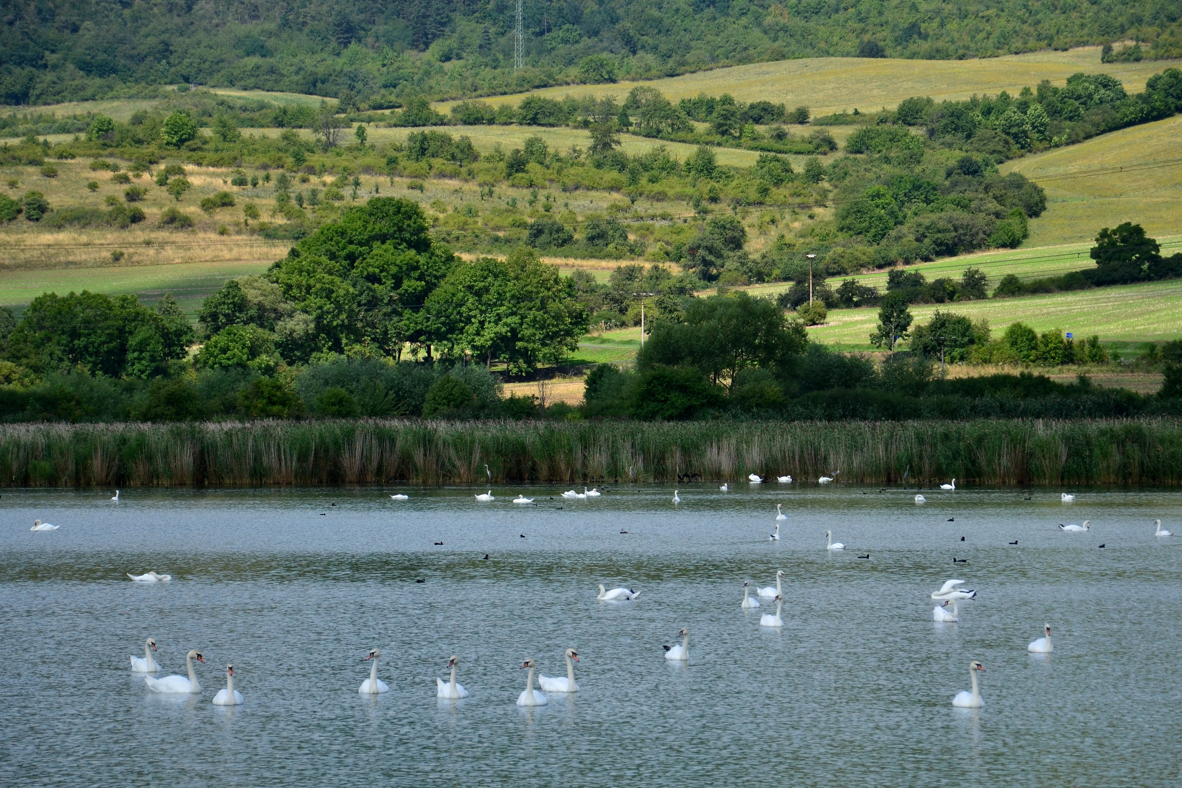
A group of white swans swimming across a calm, reed-lined pond with rolling, grassy, and forested hills in the background.
A group of swans swimming on the Vinařský rybník pond, a protected nature reserve in the Czech Republic.

Vinařský rybník history and protected-area timeline

The pond's origin is not precisely documented. It does not appear on maps from the Second Military Survey of the Habsburg Empire, carried out between 1806 and 1869, so its creation likely postdates that period, though its exact founding date remains unclear.

Until the second half of the 20th century the pond was relatively unaffected by human activity. In the 1950s, however, accelerating erosion from surrounding farmland began to wash soil into the water, gradually silting up the basin. Industrial fertilizers carried in with this soil triggered strong eutrophication of the pond, altering its water chemistry and ecology.

The protected area was formally declared on 22 November 1990 by the district national committee in Chomutov, originally as a chráněný přírodní výtvor (protected natural creation). It is now classified as a přírodní památka and is recorded in the Central List of Nature Conservation under the number 1509. In the 1990s the pond was owned by the Czech Fishing Union (Český rybářský svaz), and during this period a sharp rise in fish stocking with poorly balanced species composition, the release of semi-domesticated ducks, and hunting of waterfowl by the local Vinaře hunting association all disturbed wintering and migratory birds.

Vinařský rybník landscape and geographic character

Vinařský rybník sits in the low-relief terrain of the Mostecká pánev, within the Žatecká pánev subregion and the local Pětipeská kotlina basin. The landscape here is gently basin-shaped, with the relief sloping eastward. Elevations across the protected area run from about 282 to 289 meters above sea level, giving the site a markedly lowland character.

Geologically, the area is underlain by Tertiary Miocene clays, with Tertiary volcaniclastic basalts reaching beneath the northwestern part of the pond. The surface is covered by Quaternary sediments including clayey alluvium, peat-like slatiny, and sapropel deposits, especially around the shoreline. The pond itself is a shallow body of standing water, averaging only 70 to 80 centimeters deep, mainly fed by the Vintířovský potok, which carries water toward the Liboc River and ultimately the Ohře.
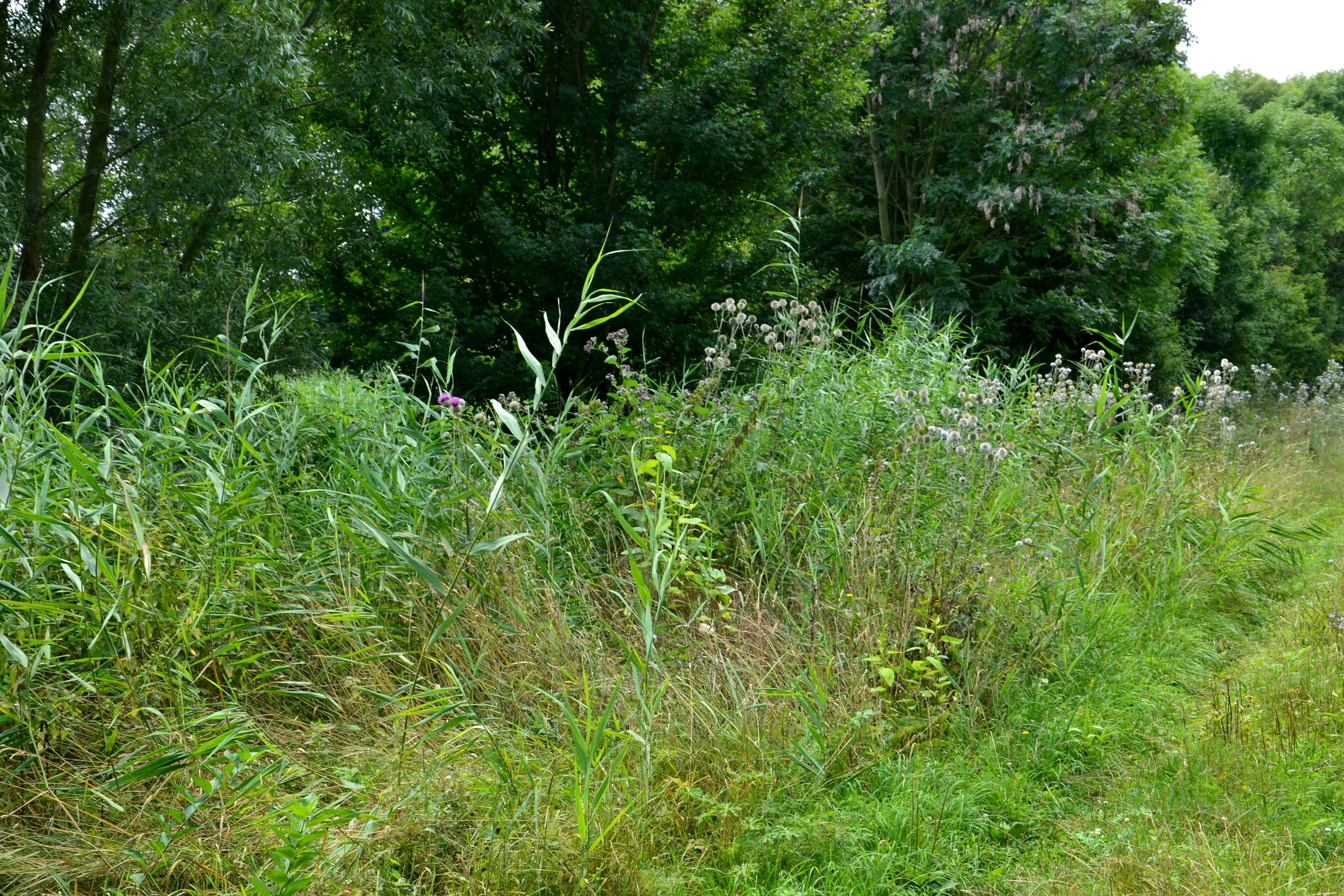
A view of green reed beds, wild grasses, and blooming thistles in front of a line of deciduous trees at Vinařský rybník.
Dense reed beds and surrounding vegetation along the shore of the Vinařský rybník pond.

Vinařský rybník ecosystems, habitats, and plant life

The ecological identity of Vinařský rybník is that of a lowland standing-water wetland with a strong reedbed and shoreline fringe. The open water itself is almost vegetation-free, but the littoral zone is dominated by dense common reed (Phragmites australis) belts, with secondary emergents including broadleaf cattail, rushes (Juncus), and various sedges (Carex). Wetland and wet-meadow specialists such as the specially protected Host's sedge (Carex hostiana), hastate leaf skullcap (Scutellaria hastifolia), and the critically endangered grass vetchling (Lathyrus nissolia) occur here, contributing to the site's botanical significance.

Along the southern shore and below the dam, ash trees, black alder (Alnus glutinosa), and crack willow (Salix euxina) form a softwood fringe, while forest-floor herbs typical of Central European hardwood floodplains, including hollowroot (Corydalis cava), yellow gagea (Gagea lutea), lesser celandine (Ficaria verna), and butterbur (Petasites hybridus), appear in the understory, mixed with common nettle and elder. Soils are predominantly fluvická černice, transitioning to smonice modální around parts of the northern shore.

The site lies within the Quitt climate classification's warm region T2, with average January temperatures of about minus 2 to minus 3 degrees Celsius and July averages of 18 to 19 degrees Celsius. Annual precipitation is roughly 550 to 700 millimeters. These conditions favor warm-lowland wetland communities rather than montane or boreal types.
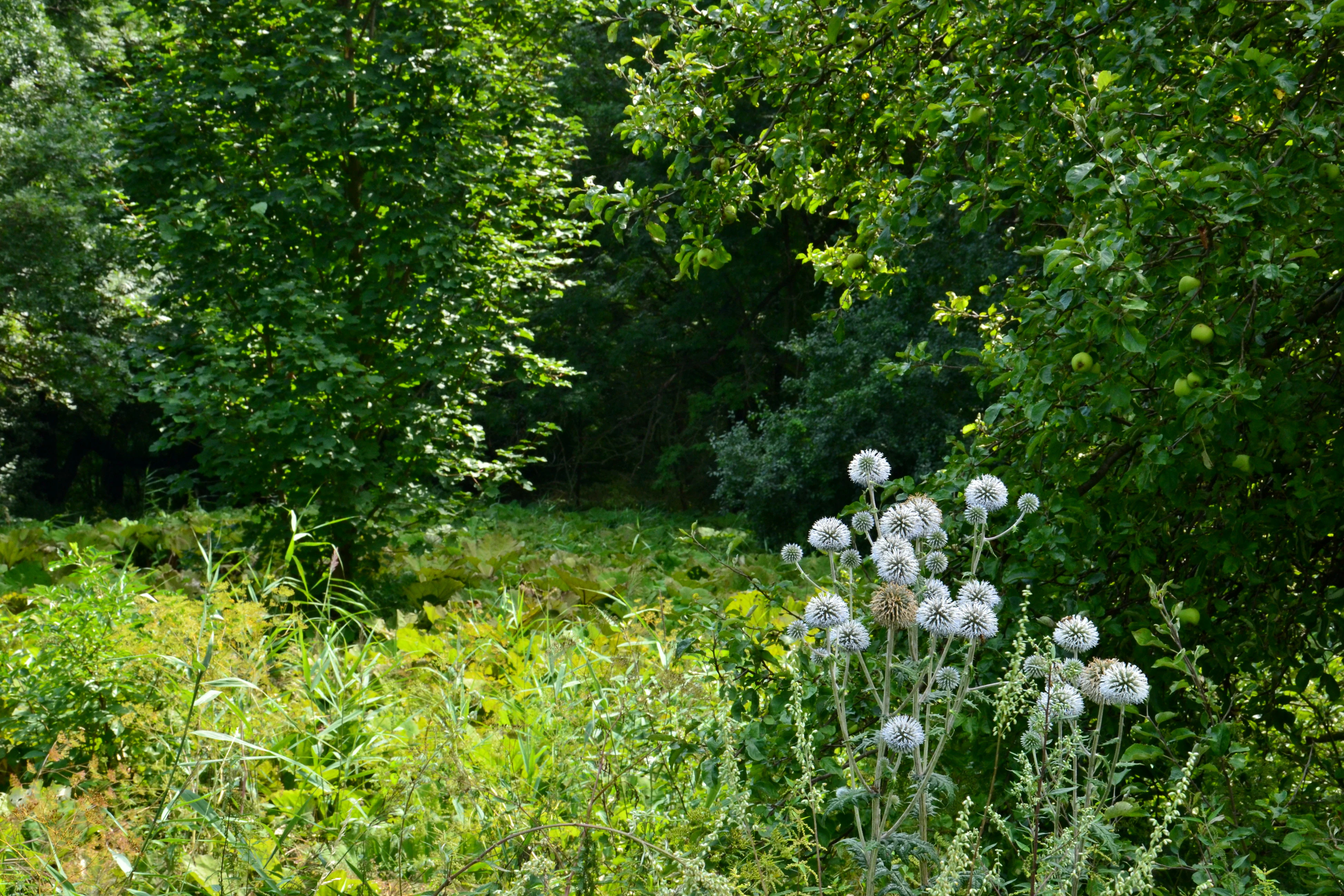
A cluster of globe thistle flowers in the foreground with a background of dense green trees and undergrowth in a park setting.
Wildflowers and dense vegetation in the Vinařský rybník nature reserve.

Vinařský rybník wildlife and species highlights

Vinařský rybník is recognized primarily for its birdlife. An older management plan for 2009 to 2018 documented two critically endangered breeding species at the site: one to two pairs of Eurasian bittern (Botaurus stellaris) and roughly five pairs of ortolan bunting (Emberiza hortulana). The shoreline and reedbed vegetation also hosted a suite of threatened species, including marsh harrier (Circus aeruginosus), black-necked grebe (Podiceps nigricollis), little grebe (Tachybaptus ruficollis), great crested grebe (Podiceps cristatus), Savi's warbler (Locustella luscinioides), spotted crake (Porzana porzana), water rail (Rallus aquaticus), and Eurasian wryneck (Jynx torquilla), with gadwall (Anas strepera), northern shoveler (Anas clypeata), and great egret (Ardea alba) recorded as autumn migration stopovers.

The pond regularly supports nesting great reed warbler (Acrocephalus arundinaceus), white-spotted bluethroat (Luscinia svecica cyanecula), and common nightingale (Luscinia megarhynchos), with bearded reedling (Panurus biarmicus) breeding irregularly. Up to thousands of barn swallows (Hirundo rustica) use the locality as a night roost. Penduline tit (Remiz pendulinus) has nested in the woody growth below the dam, and golden oriole (Oriolus oriolus) has been recorded. At the time the protected area was declared, a black-headed gull (Chroicocephalus ridibundus) colony of up to about 500 breeding pairs existed here, though it later disappeared.

Other notable vertebrates include the sand lizard (Lacerta agilis), slow worm (Anguis fragilis), grass snake (Natrix natrix), and the Eurasian otter (Lutra lutra), the last confirmed in 2013. Amphibians documented in the shoreline zone include fire-bellied toad (Bombina bombina), European tree frog (Hyla arborea), common toad (Bufo bufo), green toad (Bufotes viridis), and the critically endangered marsh frog (Pelophylax ridibundus).

Vinařský rybník conservation status and protection priorities

Vinařský rybník is protected federally as a přírodní památka, equivalent to an IUCN Category IV Species/Species Habitat Management Area. Its principal conservation value lies in preserving an entire lowland pond ecosystem, particularly its reed and shoreline vegetation, which together constitute a significant breeding habitat for protected and threatened bird species and support several protected and critically endangered plant species.

The site is part of the Doupovské hory Bird Protection Area (ptačí oblast), integrating it into a wider regional network of important sites for breeding, wintering, and migratory waterbirds. The conservation challenge at the site reflects its history: agricultural runoff in the mid-20th century caused nutrient enrichment and siltation, while 1990s-era fish stocking, semi-domesticated duck releases, and hunting pressure all disturbed wintering and migratory birds. Maintaining appropriate hydrology, water quality, reedbed extent, and fish community composition remains central to safeguarding the site's character as a functioning wetland refuge.

Top sights and standout views in Vinařský rybník

Vinařský rybník offers a compact but ecologically dense example of central European lowland wetland conservation, combining a shallow pond, dense reedbeds, and softwood shoreline vegetation within a small, formally protected footprint.

It stands out for the presence of critically endangered breeding birds such as Eurasian bittern and ortolan bunting, a rich assemblage of threatened waterbird and warbler species, and a confirmed population of Eurasian otter, all within a site that is also part of the broader Doupovské hory Bird Protection Area.

Best time to visit Vinařský rybník

As a bird-focused wetland site, Vinařský rybník has the greatest ornithological interest in spring and early summer, when reedbed species are breeding and wetland warblers, grebes, and crakes are most active. Late summer and autumn bring migratory stopovers of waterfowl and waders, while the open water and mature reed stands also offer a quieter atmosphere outside the main breeding season. The site lies outside marked hiking trails, so visits are best suited to quiet, low-disturbance exploration on foot from the surrounding villages.


Monthly climate preview

Long-term representative climate patterns and monthly averages for Vinařský rybník

Vinařský rybník Climate Normals, Annual Temperature, and Precipitation Rhythms

Historical data records monthly temperature ranges from subzero winter minima to warm summer maxima alongside steady precipitation rates. Reviewing the complete twelve-month climatology profile reveals detailed variations across the representative coordinate.
Annual mean7 °C
-3 °C18 °C
Jan-3°
Feb-2°
Mar
Apr
May12°
Jun16°
Jul18°
Aug18°
Sep13°
Oct
Nov
Dec-2°
Warmest month
July

17.8 °C

Coolest month
January

-2.7 °C

Wettest month
July

2.7 mm/day

Driest month
April

1.4 mm/day

Park location guide

Geography guide, regional context, and park location map for Vinařský rybník

Vinařský rybník park geography, regions, and map view in Czechia

Understand where Vinařský rybník sits in Czechia through a broader geographic reading of the surrounding landscape, nearby location context, and its mapped position within the national park landscape.

How Vinařský rybník fits into Czechia

Czech Republic is a landlocked Central European country with a population of approximately 10.9 million people. The nation was established as an independent state on January 1, 1993, following the dissolution of Czechoslovakia. Its capital and largest city is Prague, with other major urban centers including Brno, Ostrava, Plzeň, and Liberec.

Wider geography shaping Vinařský rybník in Czechia

The Czech Republic is a landlocked country in Central Europe. It is bordered by Germany to the west, Austria to the south, Poland to the northeast, and Slovakia to the southeast. The landscape is predominantly hilly, with the territory covering 78,871 square kilometers.

Map view of Vinařský rybník

Use this park location map to pinpoint Vinařský rybník in Czechia, understand its exact geographic position, and read its mapped placement within the surrounding landscape more clearly.

Pigeon | © OpenStreetMap contributors

Location context for Vinařský rybník

Ústecký kraj

Explore detailed imagery of wetland habitats, shoreline thickets, and low-relief basin terrain.

Vinařský rybník Photos and Landscape Scenery: Visualizing the Protected Wetland Environment

Visual records capture the distinctive lowland character of Vinařský rybník, highlighting shallow waters, dense reedbeds, and wet meadows. Examining these protected habitats provides deeper insight into the ecological features defining the regional bird sanctuary.

A group of white swans swimming across a calm, reed-lined pond with rolling, grassy, and forested hills in the background.

A wide view of Vinařský rybník from a grassy dam, showing calm water with distant hills, birds on the water, and wildflowers in the foreground.

A view of green reed beds, wild grasses, and blooming thistles in front of a line of deciduous trees at Vinařský rybník.

A cluster of globe thistle flowers in the foreground with a background of dense green trees and undergrowth in a park setting.

Park atlas

Compare surrounding wetland habitats and regional protected landscapes

Explore Other Parks and Protected Areas Near Vinařský rybník in the Region

Browsing other protected areas near Vinařský rybník reveals the broader wetland geography and lowland basin terrain of the surrounding region. Comparing adjacent nature reserves provides deeper insight into regional bird habitats and conservation networks.
A watercolor painting showing a rolling landscape with green hills, scattered trees, blossoming pink trees, and several large dark boulders in the foreground.
Natural monumentÚstecký kraj
About 2.8 km away#1 closest

North

Sluňáky Natural Monument: Geological Mapping and Protected Landscape Context

A preserved quartzite boulder field in the Ústecký kraj

Sluňáky represents a vital geological record within the Czech Republic, encompassing a distinctive group of silicified sandstone boulders. This natural monument serves as an important protected territory that illustrates the intersection of Tertiary geology and historical industrial extraction. The surrounding terrain reflects the complex volcanic and sedimentary history of the Doupovské hory foothills.

Area
0.032 km²
Established
1966
IUCN
III
Relief
Upland
A soft, painterly watercolor illustration of a rolling green landscape with distant hills, grassy meadows, and patches of trees.
Protected landscapeChomutov District
About 8.3 km away#2 closest

Southwest

Doupovská pahorkatina Nature Park: Mapped Geography and Protected Landscape Features

Upland volcanic terrain and steppe grasslands in Czech Republic.

Doupovská pahorkatina Nature Park protects a significant stretch of forest-steppe mosaics and rolling volcanic terrain in the southwestern part of the Chomutov District. This area stands out for its high density of dry grassland communities and wetland pockets along the Liboc river, providing a critical study of transitional geomorphology between the Doupov Mountains and the Žatecká pánev basin.

Area
47.7 km²
Established
1996
A watercolor painting showing a calm lake or pond surrounded by wetland vegetation, tall grasses, and distant rolling hills.
Nature reserveÚstecký kraj
About 14 km away#3 closest

Northeast

Pražská pole Nature Reserve: An Atlas of Wetland Recovery in Ústecký kraj

Protected wetland landscapes in the Czech Most Basin

Pražská pole is a remarkable nature reserve in the Ústecký kraj region, serving as a testament to natural recovery following deep brown coal mining. The site features a network of ten flooded subsidence depressions that host diverse aquatic communities, including specialized amphibians and dragonflies. This protected area offers significant value for understanding how industrial legacies transform into functional, high biodiversity wetland ecosystems within the Czech landscape.

Area
1.14 km²
Established
2024
IUCN
IV
Water
Major water bodies
Natural monumentÚstí nad Labem Region
About 15 km away#4 closest

South

Vrbina u Nové Vsi Natural Monument: Protected Habitat Mapping and Geographic Overview

Wetland and meadow conservation in the Ústí nad Labem Region

Vrbina u Nové Vsi provides a deep look into the habitat mosaic of the Doupov Mountains foothills. This protected area stands out for its concentrated distribution of ten distinct biotopes, ranging from wet alder woodlands to orchid-rich meadows, providing a comprehensive example of lowland conservation within a larger volcanic terrain context.

Area
0.113 km²
Established
2016
IUCN
IV
Relief
Upland
Natural monumentKarlovarský kraj
About 17 km away#5 closest

South

Valeč Natural Monument: Geologic and Ecological Landscapes in the Karlovarský kraj

Tracing volcanic terrain and fossil sites in the Doupovské Hory

Valeč Natural Monument offers a deep look into the volcanic geology and protected wilderness of western Bohemia. Known for its historical paleontological finds and diverse forest cover, this landscape provides an essential case study for mineralogical research and habitat preservation within the wider regional geography.

Area
5.436 km²
Established
1992
IUCN
IV
Relief
Mountain
Natural monumentKarlovy Vary District
About 17 km away#6 closest

South

Valečské sklepy Natural Monument and Protected Bat Hibernation Site in Karlovy Vary

Volcanic terrain and critical wildlife infrastructure in western Bohemia

Valečské sklepy represents a unique form of protected landscape in the Karlovy Vary District, where historical underground cellars function as a specialized natural monument. The site maintains a crucial role as a winter hibernation refuge for the critically endangered western barbastelle, embedded within the volcanic geomorphology of the Doupovské hory region.

Established
2016
IUCN
III
Relief
Mountain
Climate
Temperate
A horizontal watercolor painting depicting a soft-focus landscape with rolling green meadows, distant hills, and patches of trees.
Natural monumentÚstecký kraj
About 18 km away#7 closest

Northwest

Na loučkách II Natural Monument: Mapped Geography and Protected Upland Landscapes

Conservation areas in the Ore Mountains of the Ústecký kraj

Na loučkách II encompasses a substantial upland territory in the Czech Republic, characterized by a mix of peatland basins, heathland, and montane meadow mosaics. This natural monument serves as an essential ecological link within the Ore Mountains, protecting diverse highland terrain and supporting sensitive habitats in the Ústecký kraj administrative region.

Area
6.623 km²
Established
2013
IUCN
IV
Relief
Highland
Watercolor painting of a low-lying saline landscape with soft green vegetation, rolling hills in the background, and a warm yellow sky.
Natural monumentÚstecký kraj
About 18 km away#8 closest

Northeast

Slanisko u Škrle Natural Monument and Rare Inland Saline Landscape in the Czech Republic

Geographic analysis of halophytic habitats and protected lowland terrain

The Slanisko u Škrle natural monument serves as a key reference for inland saline ecology in the Most Basin. This site preserves mineralised grasslands and rare plant communities on a south-facing slope above the Chomutovka river, providing an essential look at the intersection of geology and sensitive habitat preservation.

Area
0.034 km²
Established
2002
IUCN
IV
Relief
Lowland

Common questions about visiting, size, designation, and location context for Vinařský rybník

Vinařský rybník FAQs for park facts, access, geography, and protected area context

Find quick answers about Vinařský rybník, including protected-area facts, park geography, trail and visitor context, and how the park fits into its surrounding country and regional landscape.
MoriAtlas Explorer

Continue Your Protected Areas Search Across the Global Atlas

Deepen your exploration by continuing the structured search for national parks and protected areas worldwide. Utilize the comprehensive filtering capabilities to compare different conservation landscapes and refine your understanding of global park geography. Discover more about the distribution and characteristics of protected natural areas.

Global natural geography