

Mori Atlas logo
Natural monumentVlčí jámy

A study of post-mining geological collapse, cave ice microclimates, and rare bryophyte habitats

Vlčí jámy Natural Monument and Protected Mining Landscape in the Czech Ore Mountains

(Přírodní památka Vlčí jámy)

Vlčí jámy preserves a complex landscape on the slopes of Blatenský vrch within the Karlovarský kraj region. This protected monument encompasses two significant medieval mining collapses, Ledová jáma and Vlčí jáma, which transformed the granite terrain into a series of rugged pits. Beyond the historical tin-extraction adits, the site serves as a vital refuge for specialized flora and fauna, including endangered moss species and bat populations that thrive within the deep, cold-trap microclimates.

ore mountainsKrušné horytin mining heritagepost-mining landscapecave icespruce forest

Vlčí jámy

Natural monument

Park overview

Structured park overview, official facts, and landscape profile for Vlčí jámy

Vlčí jámy park facts, protected area profile, and essential visitor context

Review the core facts for Vlčí jámy, including designation, size, terrain, visitor scale, habitats, and operating context in one park-focused overview.

About Vlčí jámy

Vlčí jámy is a small but unusually focused protected natural monument in the Czech Republic's Ore Mountains, the long upland range that forms much of the northwestern border of Bohemia. The monument lies on the southwestern flank of Blatenský vrch, a hill that has been known for centuries for its tin deposits and is surrounded by the historic mining landscape of Horní Blatná and Potůčky. Its setting puts it firmly within the higher, cooler belt of the Krušné hory, an area characterized by montane spruce forests, blanket bogs on the upland plateau, and a long history of ore extraction.

The protected site is composed of two collapsed mining features that originated from late medieval workings on tin-bearing greisen veins. The first, Ledová jáma, is a very narrow shaft up to roughly twenty meters deep, carved out by removing a tin-ore band called the Jiří zone. The second, Vlčí jáma, formed through collapse after the removal of the Wolfgang zone and now appears as a striking ravine-like depression more than 120 meters long, about 14 meters wide, and around 20 meters deep. Together they form a recognizable pair of mining-derived landforms that have become part of the local cultural landscape as well as a conservation subject in their own right.

What gives the monument scientific and ecological interest is not only the shape of these collapses but also the exceptional microenvironment they create. Because Ledová jáma is so narrow, air circulation is restricted, and historically snow and ice accumulated inside it without fully melting during summer. This natural cold-storage effect interested early modern observers; a written reference from 1813 even reports the use of ice from the pit to treat wounded soldiers from the Battle of Leipzig. In modern times, the integrity of this microclimate has been damaged: in 2005, almost two tons of snow and ice were illegally removed for a sculptural project, and the droughts of 2017 through 2019 further disrupted the ice formation, causing the cave ice to disappear.

In parallel, the exposed mineral veins and disturbed ground around the pits provide a substrate on which a relict bryoflora has survived, including mosses that are otherwise extremely rare in Central Europe and linked chemically to copper-rich outcrops. The wider surroundings still carry the species composition typical of upland Ore Mountain forests, with young spruce stands and the understory plants typical of acid, cool habitats. As a result, Vlčí jámy stands out as a protected landscape where geology, mining heritage, microclimate, and rare biology meet within a footprint of just over a hectare.

Quick facts and research context for Vlčí jámy

Vlčí jámy is a Czech natural monument (přírodní památka), equivalent to IUCN Category III, situated in the Krušné hory mountains of the Karlovarský kraj. The protected area covers roughly 1.4 hectares at elevations between about 984 and 1010 meters above sea level on the southwestern slope of Blatenský vrch. It was established by the District National Committee in Karlovy Vary on 5 September 1975.

The reserve consists of two collapse pits shaped by medieval tin mining: Ledová jáma (the Ice Pit) and Vlčí jáma (the Wolf Pit). Protection targets include the surviving cave ice microclimate, mining heritage remains that are also separately heritage-protected, populations of critically endangered mosses tied to exposed ore veins, and rare fauna including the garden dormouse and bat species using the old workings.

Protection and recognition

Terrestrial protection status, management scope, and recognition context for Vlčí Jámy

Vlčí Jámy Protection Status and Documented Conservation Scope

Examine the documented terrestrial protection status, management scope, and official designation history recorded for Vlčí Jámy. Review verifiable conservation metrics and administrative boundaries associated with this protected natural area.

Protection details

Protection scope
Terrestrial
Transboundary protection
No
Park context

Deeper park guide and search-rich context for Vlčí jámy

Vlčí jámy history, landscape, wildlife, and travel context

Explore Vlčí jámy through its history, landscape character, ecosystems, wildlife, conservation priorities, cultural context, and seasonal travel timing in a structured park guide built for atlas discovery and search intent.

Why Vlčí jámy stands out

Vlčí jámy is best known for merging two unusual features into one tiny protected site: a persistent cave-ice phenomenon and a relict population of critically endangered mosses that grow directly on exposed copper-bearing ore veins. The Ledová jáma, the higher of the two pits, became a natural curiosity because its narrow geometry and deep shaft limited air exchange. Snow and ice accumulated at the bottom and historically survived the warmer months, so the pit functioned as a year-round cold trap. Historical accounts link ice from this location to medicinal use after the 1813 Battle of Leipzig. The same geological substrate that supported tin mining also carries the unusual chemistry that allows rare bryophytes to colonize the exposed ore. The site is also valued for its medieval mining heritage. Pits and adits associated with the historical extraction of cassiterite-rich greisen veins give the landscape its rugged character, and the morphology of the collapses is part of the reason for protection.
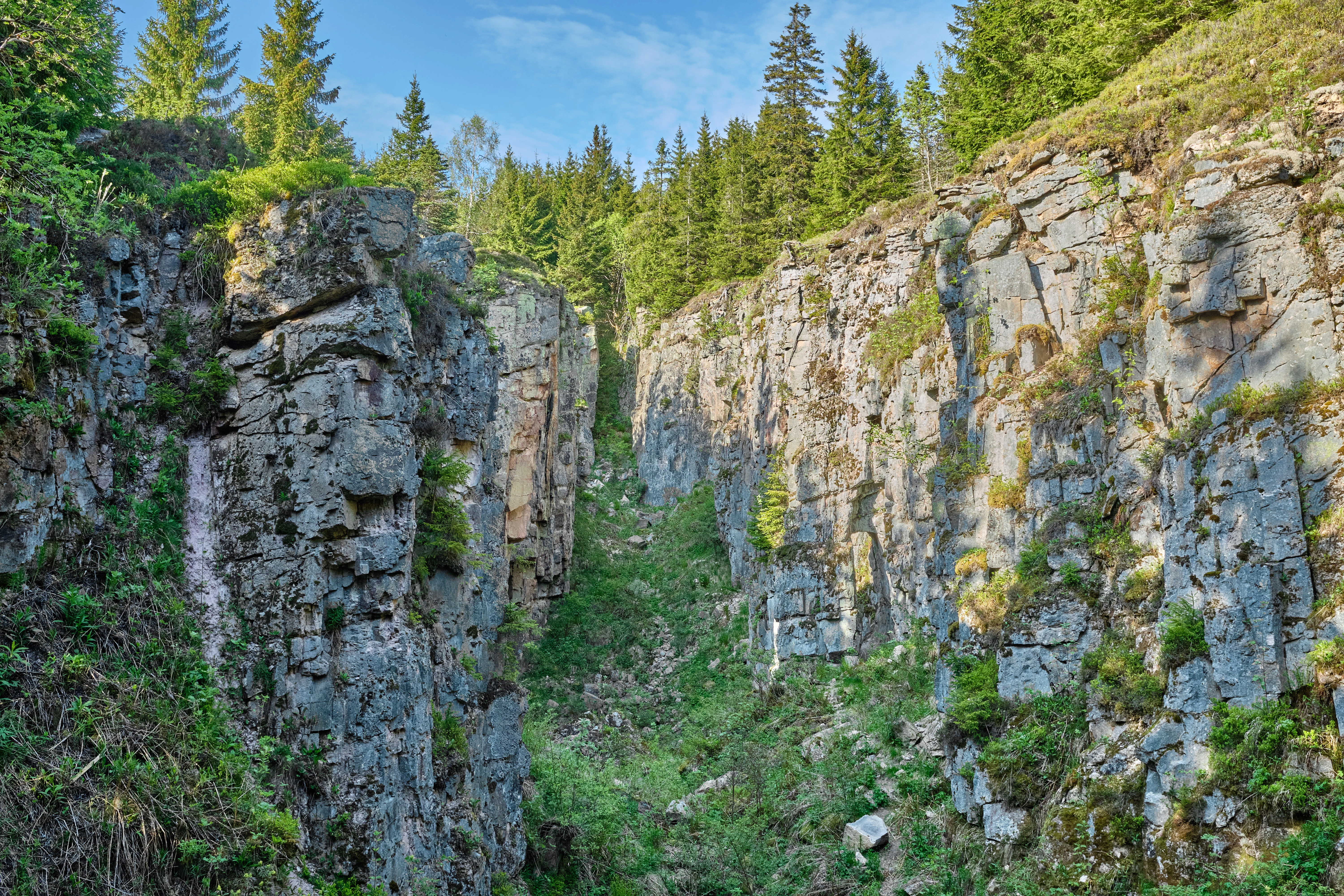
Vlci jamy ice cave, May 2023
Natural monument Vlci jamy, located in Horni Blatna, Karlovy Vary district

Vlčí jámy history and protected-area timeline

The pits that now make up Vlčí jámy originated from medieval tin mining on Blatenský vrch. Medieval miners extracted cassiterite from greisen veins, leaving behind two main workings: a narrow shaft on the upper part of the slope, later known as Ledová jáma, and a broader zone whose collapsed galleries gave rise to the elongated Vlčí jáma below. The rugged profile of both pits, with their spoil heaps and adit mouths, is therefore as much a record of centuries-old extractive activity as it is a natural landform.

Interest in the pits grew beyond industrial concerns once their unusual climate became known. In 1813 a written source mentions ice from Ledová jáma being used medicinally on soldiers wounded at the Battle of Leipzig, suggesting that the local population had long recognized the cave as a natural ice source. At the beginning of the twentieth century, the Krušnohorský spolek of Horní Blatná turned the site into a local attraction by building a stone staircase that allowed visitors to descend into the Ice Pit.

The area received formal conservation recognition in the second half of the twentieth century. On 5 September 1975, the District National Committee in Karlovy Vary declared the territory a protected natural monument, with the remains of both pits designated for protection alongside their biological and microclimatic values. The mining structures themselves are separately listed as cultural heritage, recognizing the joint natural and historical importance of the site.

Vlčí jámy landscape and geographic character

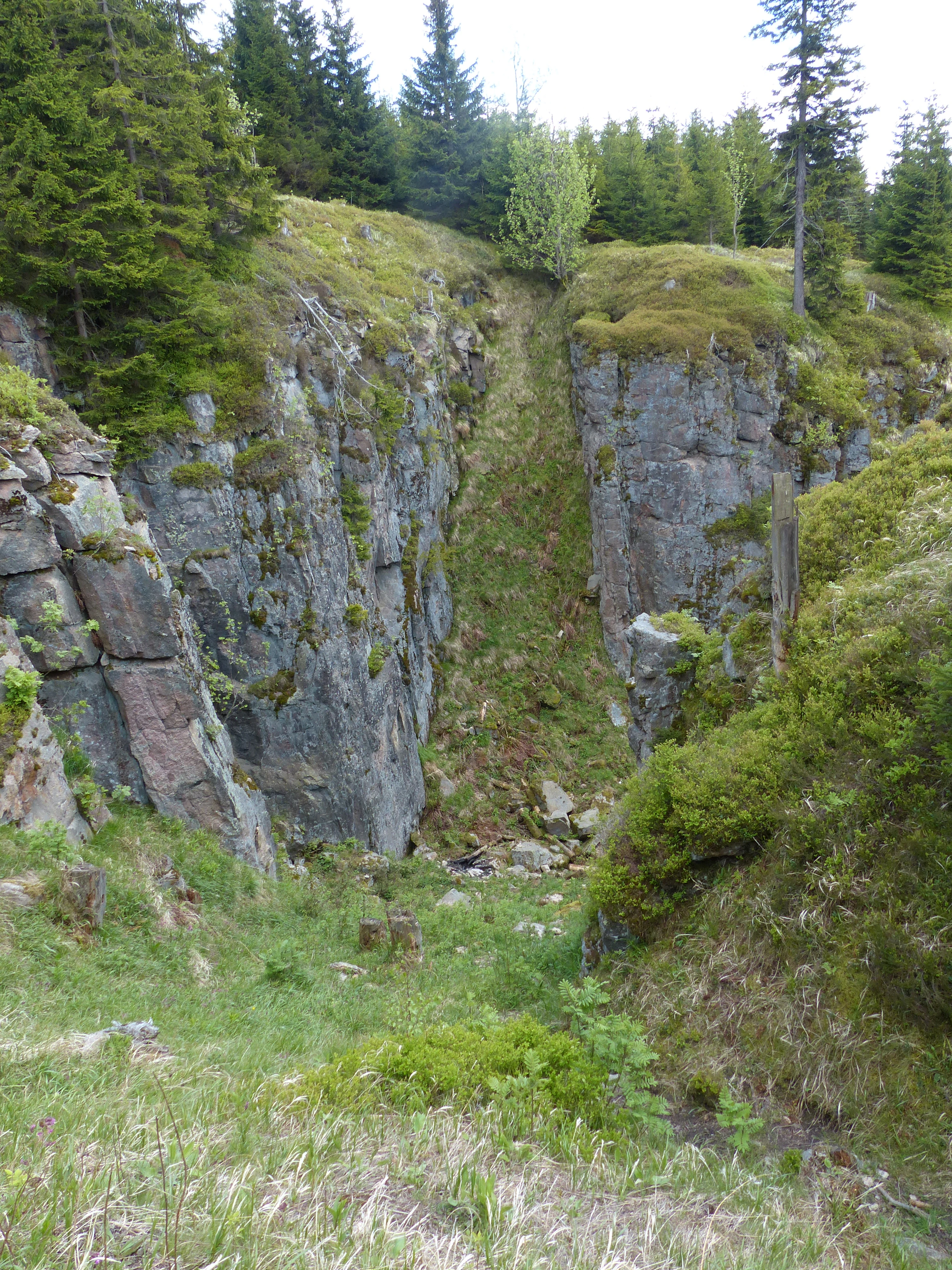
The landscape of Vlčí jámy is shaped less by natural erosion than by centuries of underground mining followed by collapse. The two protected pits appear as abrupt, steep-walled depressions on the southwestern flank of Blatenský vrch, framed by spruce forest. Their surfaces combine bare rocky scarps, accumulations of loose debris, and the partially preserved openings of old mine adits, giving the site a rugged, almost lunar feel within an otherwise densely wooded mountain slope.

Geologically, the deposits belong to the Jáchymovská hornatina subunit of the Klínovecká hornatina within the Krušné hory. The bedrock is a medium-grained biotite granite, locally porphyritic, cut by greisen veins that carry tin, tungsten, lithium, molybdenum, and bismuth minerals. Cassiterite was the principal economic target, but the veins also contain topaz, fluorite, and tourmaline. Erosion by frost, plant roots, and careless visitor traffic continues to break down the exposed rock faces.

The climate of the area belongs to the cold CH6 zone of the Quitt classification, with January means around minus four to minus five degrees Celsius, July means around 14 to 15 degrees Celsius, and annual precipitation of roughly 1000 to 1200 millimeters. Snow cover lies for about 120 to 140 days a year, and frost days are far more common than summer days. Drainage from the area is partly directed into the Blatenský vodní příkop, an artificial channel, while the natural catchment feeds the Blatenský potok.
Blatensky vrch view
The peak of Blatensky vrch, also known as Plattenberg

Vlčí jámy ecosystems, habitats, and plant life

Ecologically, Vlčí jámy represents a small but unusually specialized habitat within the broader spruce-dominated forests of the Krušné hory. The plateau and upper slopes carry young montane spruce stands with a typical understory of hairy(reed grass) and bilberry, reflecting the acidic, cool conditions common across the range.

The bottoms and sheltered sides of the pits contrast with the surrounding forest. Inside Vlčí jáma, conditions resemble subalpine tall-forb communities, with prominent populations of large-leaved buttercup, greater wood-rush, and Alpine coltsfoot. These species normally belong to higher elevations and indicate how the deep, cold trap mimics conditions found well above the site's actual altitude of around 1000 meters.

The site's most distinctive ecological value lies in its bryoflora. The combination of exposed ore-bearing rock, cool air drainage, and persistent moisture creates substrate on which critically endangered mosses can survive in an otherwise hostile regional landscape. These mosses are tightly linked to the chemistry of the underlying veins, so they cannot simply migrate elsewhere if conditions change. Their presence is the main biological reason for the monument's strict protection status.

Vlčí jámy wildlife and species highlights

Fauna in Vlčí jámy is modest in visible diversity but high in conservation significance. The headline species is the garden dormouse, whose viable population here is one of the reasons the area was protected. This small rodent is critically endangered across much of Central Europe, making the Ore Mountain pits an important refugium for the species in the Czech Republic.

Reptiles also use the warm, sun-exposed rock edges around the pits. The common viper appears here as a critically endangered population, while the slow worm occurs occasionally near the limits of its ecological range, and the viviparous lizard is more commonly seen basking on the stones. Together these species signal the value of the rocky, open microhabitats within an otherwise forested mountain setting.

The largest single group of animals actually using the monument is bats, which roost in the remaining sections of old mine adits. Recorded species include the northern bat, the brown long-eared bat, the Daubenton's bat, and the whiskered bat. The combination of cool, stable underground spaces and a forested landscape with abundant insects makes the site a useful seasonal or year-round roosting location for these protected mammals.

Vlčí jámy conservation status and protection priorities

Vlčí jámy is a textbook example of how very small protected areas can serve highly specialized conservation goals. The monument was designated to safeguard three tightly linked values: the microclimate of the Ice Pit, the relict bryophyte flora tied to exposed ore veins, and the nationally important population of garden dormouse supported by the site's structure of pits, adits, and surrounding forest.

The site's recent history also illustrates how vulnerable these values are to small-scale human actions. The illegal removal of nearly two metric tons of snow and ice from Ledová jáma in 2005 directly altered the cold trap that had defined the pit for centuries, and a sequence of dry years between 2017 and 2019 further stressed the system, contributing to the disappearance of cave ice. Once lost, such a microclimate is unlikely to re-establish quickly, which is why the incident is often cited in Czech conservation discussions about the fragility of small underground ecosystems.

At a broader scale, Vlčí jámy contributes to the network of protected natural monuments in the Karlovarský kraj, complementing other sites that together maintain the characteristic mix of mining heritage and upland biodiversity in the Ore Mountains. The site's dual listing as a natural monument and a cultural heritage site also reflects a wider Czech policy approach in which post-mining landscapes are recognized both for their ecological recovery and for their historical significance.

Vlčí jámy cultural meaning and human context

The cultural context of Vlčí jámy is inseparable from centuries of tin mining in the Ore Mountains. The Horní Blatná area, with its medieval and early modern silver and tin operations, is one of the most important historic mining landscapes in Bohemia, and Blatenský vrch itself has long been identified with extractive activity. The pits at Vlčí jámy are among the smaller but more visible surface expressions of that mining tradition, and the surviving adit mouths and spoil heaps carry that history into the present.

Local communities have interacted with the pits in ways that extend beyond industry. Ice harvesting from Ledová jáma, as referenced in 1813, points to traditional uses of natural cold storage in mountain communities, while the early twentieth-century stone staircase built by the Krušnohorský spolek of Horní Blatná shows how the site became a place of regional pride and local tourism. The mining remains are now formally listed as cultural monuments, acknowledging this layered relationship.

The current protection regime also reflects a broader Czech appreciation of small, locally meaningful sites. Rather than being valued only as scenery, the pits are understood as places where industrial heritage, ecological recovery, and community memory intersect, an approach typical of how the Krušné hory region has come to terms with the legacy of its mining past.

Top sights and standout views in Vlčí jámy

Vlčí jámy stands out because it compresses several distinctive qualities into a single tiny reserve: a medieval tin-mining collapse landscape, a historically famous cave-ice pit, and one of the few Czech locations for critically endangered ore-loving mosses. Its size belies the fact that it preserves features of regional, national, and even central European significance.

The site's tight integration of values is itself a highlight. The same geological vein system that supported mining also generated the substrate for rare bryophytes; the same shaft geometry that produced tin also trapped cold air and snow; the same abandoned adits that miners left behind now shelter bats. This overlap of natural and cultural heritage makes Vlčí jámy unusually informative for understanding how post-mining sites can become conservation priorities.

For visitors, the reserve offers a highly compressed experience of the Ore Mountains: a short walk from Horní Blatná along a red-marked trail leads past both pits within a small area, with viewpoints and a nearby section of the A. Günther educational trail providing context about the surrounding landscape.

Best time to visit Vlčí jámy

Late spring and early summer is a reliable period for visiting Vlčí jámy because the surrounding Ore Mountain forests are accessible on foot, snow lingers only at higher elevations, and plant identification along the trail is easier when understory species such as bilberry and hairy reed grass are in active growth. May and June also tend to offer long daylight hours for combining the site with broader exploration of Blatenský vrch.

Summer visits are most pleasant in the morning or after rainfall, when the rocky terrain around the pits is less exposed and bat-friendly twilight conditions arrive later. The site sits at roughly 1000 meters elevation, so even in midsummer temperatures are typically cooler than in the lowlands, and rain gear is advisable. Snow can persist on shaded ground around the pits into late spring, which is itself part of the site's character.

Winter visits offer a different perspective, since the cold-trap behavior of Ledová jáma was historically most visible in this season. However, access via the red-marked trail may be affected by snow conditions, and visitors should expect potentially difficult footing on icy sections above and around the pits.


Monthly climate preview

Measured temperature ranges and precipitation patterns across representative coordinates

Vlčí jámy Climate Normals and Long-Term Weather by Month

Long-term representative records reveal annual temperature swings from sub-zero winter minimums to warm summer maximums alongside steady daily precipitation rates. Examining the complete monthly climate profile provides deeper analytical insight into multi-year meteorological rhythms.
Annual mean7 °C
-3 °C17 °C
Jan-3°
Feb-2°
Mar
Apr
May12°
Jun15°
Jul17°
Aug17°
Sep13°
Oct
Nov
Dec-1°
Warmest month
July

17.5 °C

Coolest month
January

-2.5 °C

Wettest month
July

2.8 mm/day

Driest month
April

1.4 mm/day

Park location guide

Geography guide, regional context, and park location map for Vlčí jámy

Vlčí jámy park geography, regions, and map view in Czechia

Understand where Vlčí jámy sits in Czechia through a broader geographic reading of the surrounding landscape, nearby location context, and its mapped position within the national park landscape.

How Vlčí jámy fits into Czechia

Czech Republic is a landlocked Central European country with a population of approximately 10.9 million people. The nation was established as an independent state on January 1, 1993, following the dissolution of Czechoslovakia. Its capital and largest city is Prague, with other major urban centers including Brno, Ostrava, Plzeň, and Liberec.

Wider geography shaping Vlčí jámy in Czechia

The Czech Republic is a landlocked country in Central Europe. It is bordered by Germany to the west, Austria to the south, Poland to the northeast, and Slovakia to the southeast. The landscape is predominantly hilly, with the territory covering 78,871 square kilometers.

Map view of Vlčí jámy

Use this park location map to pinpoint Vlčí jámy in Czechia, understand its exact geographic position, and read its mapped placement within the surrounding landscape more clearly.

Pigeon | © OpenStreetMap contributors

Location context for Vlčí jámy

Karlovarský kraj

Visual reference for rugged terrain, rocky scarps, and unique protected habitats

Vlčí jámy Photos and Landscape Imagery: Exploring Ore Mountains Scenery

Visual documentation reveals the rugged terrain, steep rocky scarps, and dense spruce forest surrounding the Vlčí jámy protected monument. Examining these detailed landscape photographs helps researchers understand the distinctive morphology of the medieval mining collapses and rare microhabitats.

Vlci jamy ice cave, May 2023

Ice pit at Plattenberg

Blatensky vrch view

Park atlas

Compare adjacent mountain reserves, forest terrain, and protected landscapes.

Parks Near Vlčí Jámy and Protected Areas in the Surrounding Region

Visitors exploring Vlčí jámy can continue browsing other protected areas throughout the surrounding mountainous terrain. Comparing adjacent nature reserves provides deeper geographic context on regional conservation and local geological formations.
Natural monumentKarlovy Vary Region
About 8.1 km away#1 closest

Southwest

Rudenská luční prameniště Natural Monument: Protected Mountain Wetland Atlas

Karlovy Vary Region Ore Mountains landscape mapping

Rudenská luční prameniště is a protected mountain wetland in the Ore Mountains, defined by a distinct mosaic of spring fens, peat deposits, and mountain meadows. Its geographic layout, spanning twenty three hectares across sloping terrain, creates a vital drainage system for the local landscape. By examining this protected site, you can better understand the unique hydrological and botanical features that distinguish these rare mountain mire complexes from the surrounding highland forests.

Area
0.232 km²
Established
2020
IUCN
IV
Relief
Mountain
Nature reserveSachsen
About 11 km away#2 closest

Northwest

Friedrichsheider Hochmoor Nature Reserve: Geography and Protected Bog Landscape in Sachsen

High-elevation peatland and bog pine forest mapping

Situated at 800 meters above sea level near Sosa, Friedrichsheider Hochmoor serves as a cornerstone of peatland conservation in the Erzgebirge. This reserve is defined by its thick peat body and dense Spirken moor forest, offering a rare look at near-intact mire ecosystems that support diverse Sphagnum mosses and subarctic plant communities within a protected regional framework.

Area
0.19 km²
Established
1967
IUCN
IV
Nature reserveSachsen
About 12 km away#3 closest

East

Fichtelberg Nature Reserve: Mapped Protected Landscapes and Geography of the Saxon Erzgebirge

High-altitude mountain meadows, subalpine mires, and rare periglacial landforms.

Fichtelberg Nature Reserve protects a mosaic of high-altitude habitats across the Erzgebirge mountain range. This area features rare Nardus grasslands, spruce forests, and waterlogged mire systems. The landscape is defined by its complex ice-age legacy, containing notable frost-patterned ground structures that provide an essential window into the natural history of Saxony.

Area
2.09 km²
Established
2008
IUCN
IV
Nature reserveSaxony
About 13 km away#4 closest

West

Großer Kranichsee Nature Reserve: Protected Raised Bog Geography and Ore Mountain Landscapes

Watershed moorland, mountain pine forests, and Saxony high plateau geography.

Großer Kranichsee serves as a primary example of an intact raised bog system in the Ore Mountains. The reserve features rare peat-forming vegetation and highland bog forests, occupying a high-altitude plateau that bridges the border between Saxony and the Czech Republic. Its geographic significance stems from its role as a triple watershed, defining the drainage patterns for three distinct regional river systems within the protected Erzgebirgskamm zone.

Area
6.11 km²
Established
1912
Nature reserveSaxony
About 16 km away#5 closest

West

Dreibächel Nature Reserve: Mapping the Old-Growth Spruce Stands of the Western Ore Mountains

A historic protected landscape and mountain watershed in Saxony, Germany

Dreibächel serves as a living archive of traditional forest management, holding the distinction of containing the oldest spruce trees in Saxony. Located on the slopes of the Schneehübel, the reserve is characterized by a dense, multi-layered mountain forest canopy and the confluence of three vital streams. The area remains a essential site for observing historical plenterwald ecology and the natural hydrology of the Westerzgebirge region.

Area
0.147 km²
Established
1961
IUCN
IV
Nature reserveSachsen
About 16 km away#6 closest

North

Conradswiese Nature Reserve: Geographic Overview of the Saxon Ore Mountains Forest Meadow

Protected mountain meadow and mixed forest terrain in Sachsen.

Conradswiese encompasses a distinct Waldwiese clearing embedded within the Bergmischwald of the western Ore Mountains. Located near the Morgenleithe, this nature reserve is positioned along a watershed boundary between two river systems, making it a point of geographic interest for those exploring the natural heritage and silvicultural history of Germany.

Area
38.97 km²
IUCN
IV
Nature reserveSaxony
About 17 km away#7 closest

Northwest

Am Riedert Nature Reserve: Protected Mountain Forest Geography in Saxony, Germany

Analyzing the ecological boundaries and Hercynian mountain mixed forest terrain

Am Riedert is a compact but ecologically important nature reserve situated on the rugged slopes of the western Erzgebirge. This site protects a significant example of mountain mixed forest, characterized by its mature silver fir populations and active natural regeneration. By examining its location south of the Zwickauer Mulde river, visitors can trace the intersection of Saxon history and conservation within this unique protected landscape.

Area
0.185 km²
Established
1961
IUCN
IV
Relief
Mountain
Nature reserveÚstecký kraj
About 18 km away#8 closest

East

Vápenka v Háji u Loučné pod Klínovcem: Nature Reserve and Calcareous Landscape Map

Examining rare flora and industrial heritage in Ústecký kraj.

Vápenka v Háji u Loučné pod Klínovcem protects an 8.37 hectare site defined by its unusual dolomitic geology and history of lime extraction. This landscape hosts a specialized assemblage of critically endangered fungi and plants, offering a distinct contrast to the acidic soils of the surrounding Ore Mountains.

Area
0.084 km²
Established
2024
IUCN
IV
Relief
Mountain

Common questions about visiting, size, designation, and location context for Vlčí jámy

Vlčí jámy FAQs for park facts, access, geography, and protected area context

Find quick answers about Vlčí jámy, including protected-area facts, park geography, trail and visitor context, and how the park fits into its surrounding country and regional landscape.
MoriAtlas Explorer

Continue Your Protected Areas Search Across the Global Atlas

Deepen your exploration by continuing the structured search for national parks and protected areas worldwide. Utilize the comprehensive filtering capabilities to compare different conservation landscapes and refine your understanding of global park geography. Discover more about the distribution and characteristics of protected natural areas.

Global natural geography