
Mori Atlas logo
Natural monumentVrbina u Nové Vsi

Understanding the mapped habitat mosaics and regional ecological significance of this volcanic upland site

Vrbina u Nové Vsi Natural Monument: A Protected Wetland and Meadow Landscape in the Czech Republic

Vrbina u Nové Vsi represents a compact but ecologically rich protected area in the southeastern foothills of the Doupov Mountains. Within the Ústí nad Labem Region, this natural monument encompasses a unique mosaic of wet alder forests, damp thistle meadows, and aquatic pond margins. The site serves as a vital refuge for rare orchid species and diverse amphibian populations, functioning as an essential link within the broader Ohře river basin ecological network.

wet meadow nature monumentorchid habitatamphibian breeding siteDoupov Mountainswet alder forestvolcanic upland
A flat, stylized digital illustration depicting a mountainous valley with a waterfall cascading from a rocky cliff into a river, surrounded by trees and clouds under a setting sun.

Vrbina u Nové Vsi

Natural monument

Park overview

Structured park overview, official facts, and landscape profile for Vrbina u Nové Vsi

Vrbina u Nové Vsi park facts, protected area profile, and essential visitor context

Review the core facts for Vrbina u Nové Vsi, including designation, size, terrain, visitor scale, habitats, and operating context in one park-focused overview.

About Vrbina u Nové Vsi

Vrbina u Nové Vsi occupies a shallow depression in the southeastern part of the Doupovské hory, the broad volcanic massif in northwest Bohemia. The terrain was shaped by Tertiary volcanic activity and later covered with Quaternary organic sediments, creating conditions that today support a patchwork of wetland, meadow, and woodland habitats within an area of just over eleven hectares.

The site's character centres on a partially silted pond surrounded by damp meadows, marshy alder stands, dry grassland patches, and scrub. Such a concentration of biotope types in a single small protected area is the defining feature of Vrbina u Nové Vsi; ten habitat categories have been mapped here, ranging from wet alder forests making up nearly forty percent of the area to narrow strips of dry narrow-leaved grassland and wet willow scrub.

Ecologically, the monument's role extends beyond the bounds of the protected perimeter. It sits within the much larger European Significant Site and Bird Protection Area known as Doupovské hory, contributing stepping-stone habitat for meadow plants, amphibians, and birds within the broader mountain landscape. The site's orchid, cottongrass, and amphibian populations give Vrbina u Nové Vsi a conservation significance that exceeds its modest footprint.

The protected area lacks any marked hiking trail. Its eastern edge is bordered by road II/194, which is also followed by the regional cycle route between Valeč and Mašťov, providing the closest public access to the monument.

Quick facts and research context for Vrbina u Nové Vsi

Categorized as a habitat and species management area under the IUCN framework, Vrbina u Nové Vsi was designated in early 2016 by the Regional Authority of the Ústecký kraj and is registered under number 6185 in the Central List of Nature Conservation. Geologically, the site sits on Tertiary volcanic bedrock blanketable by Quaternary organic sediments, in the Rohozecká vrchovina sub-unit of the Doupov Mountains, and hydrologically it belongs to the Ohře river basin via small unnamed streams feeding the nearby Velký Rohozec pond.

The protected territory is unusually biotope-rich: ten habitat types occur within a footprint of just over eleven hectares, with marsh alder forests and damp thistle meadows dominating the area and a partially silted pond anchoring the wetland character.

Protection and recognition

Examining official designation records and management frameworks for Vrbina u Nové Vsi.

Vrbina u Nové Vsi Protection Status and Terrestrial Conservation Scope

Vrbina u Nové Vsi maintains a defined terrestrial protection scope within its regional conservation framework. Official records compile available designation data and management parameters to outline the legal status of the protected landscape.

Protection details

Protection scope
Terrestrial
Park context

Deeper park guide and search-rich context for Vrbina u Nové Vsi

Vrbina u Nové Vsi history, landscape, wildlife, and travel context

Explore Vrbina u Nové Vsi through its history, landscape character, ecosystems, wildlife, conservation priorities, cultural context, and seasonal travel timing in a structured park guide built for atlas discovery and search intent.

Why Vrbina u Nové Vsi stands out

The monument is recognized above all for its species-rich wet meadows and amphibian breeding habitat. Ten distinct biotopes occur within its small footprint, with marsh alder forests and damp thistle meadows together making up nearly sixty percent of the area, while orchid-rich meadows supporting Dactylorhiza majalis and Eriophorum latifolium contribute strongly to its floristic profile, and the pond and its margins sustain regionally important amphibian populations.
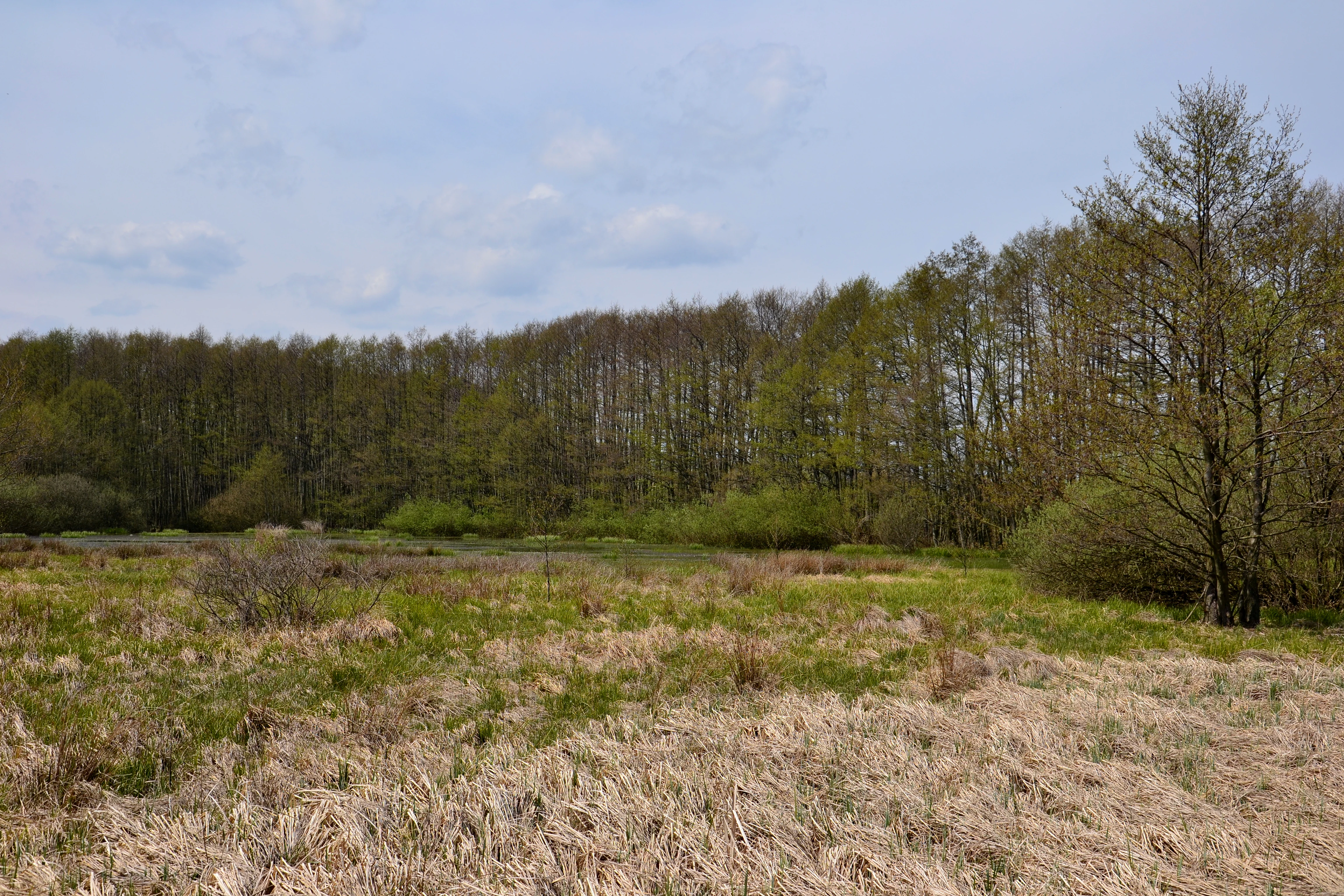
A wide shot of a wetland area with dried grasses in the foreground and a line of trees in the background under a blue sky.
A view of the wetland and forest edge within the Vrbina u Nové Vsi natural monument.

Vrbina u Nové Vsi history and protected-area timeline

The territory of Vrbina u Nové Vsi was declared a nature monument (přírodní památka) by the Regional Authority of the Ústecký kraj with effect from 6 February 2016, fulfilling a need to safeguard an unusually species-rich cluster of meadow and wetland habitats within the Doupov Mountains. The site is recorded under registration number 6185 in the Central List of Nature Conservation, and its designation has placed the meadow and pond complex under formal protection as a habitat and species management area within the national conservation framework.

Vrbina u Nové Vsi landscape and geographic character

The monument lies in a low-lying pocket within the Rohozecká vrchovina, a sub-unit of the Doupov Mountains formed by Tertiary volcanic rocks that, away from the outer mountain fringe, are covered by Quaternary organic sediments. Topographically, it consists of a shallow depression containing a partially silted pond, with soils developed as eutrophic cambisol on the better-drained ground and fluvic gleysols in the wettest sections. The surrounding relief is gently rolling rather than steep, characteristic of this part of the Doupov highland.

The local climate is mildly warm and is classified as MT3. January average temperatures are roughly minus three to minus four degrees Celsius and July averages sit between sixteen and seventeen degrees, while annual precipitation totals between approximately 600 and 750 millimetres. In the northwestern corner, unnamed brooks rise and flow along the boundary before feeding the nearby Velký Rohozec pond; from there water continues via Dolánecký potok and the Leska into the Liboc, situating the monument firmly within the wider Ohře river basin.

Vrbina u Nové Vsi ecosystems, habitats, and plant life

Ten biotope types are recorded across the protected area. Wet alder forests dominate at about thirty-nine percent of the area, followed by moist thistle meadows at roughly twenty percent. Stintingly moist Molinia meadows and mesophilic oat-grass meadows each contribute around ten percent, while tall sedge vegetation, tall mesophilic and xerophilic shrubs, and eutrophic vegetation of muddy substrates make up smaller shares. Narrow-leaved dry grassland, wet willow scrub, and submerged macrophyte communities in the open water complete the biotope mosaic and reinforce the site's ecological diversity.

The site's botanical interest is strongest in its orchid-rich and cottongrass-rich damp meadows, where highly specialized wetland flora persists in the otherwise agricultural upland matrix. Its faunal interest centres on standing water and wet margins that sustain rich amphibian breeding populations and on meadow habitats that support invertebrate communities typical of Central European floodplain and foothill landscapes.

Vrbina u Nové Vsi wildlife and species highlights

Vrbina u Nové Vsi is regionally significant for its concentrated amphibian fauna. It shelters critically endangered marsh frogs (Pelophylax ridibundus) and strongly endangered pool frogs (Pelophylax esculentus) alongside very large populations of fire-bellied toads (Bombina bombina); great crested newts (Triturus cristatus) and smooth newts (Lissotriton vulgaris) occur here in tens of individuals, and common toads (Bufo bufo) are also present on the site.

Among protected plants the monument hosts the May orchid (Dactylorhiza majalis subsp. majalis) in low double-digit numbers and broad-leaved cottongrass (Eriophorum latifolium) in populations of several hundred individuals, while the globally rare globeflower (Trollius altissimus) was last documented on the site in 2010 and remains a priority species for continued monitoring.

Vrbina u Nové Vsi conservation status and protection priorities

The monument is recognized as a habitat and species management area under the IUCN framework and functions as a local anchor within the European Significant Site and Bird Protection Area of the Doupov Mountains. By buffering meadow and pond-edge habitats against surrounding agricultural intensification and drainage, it supports regional populations of orchids, cottongrass, and amphibians of conservation concern that would otherwise be highly vulnerable in this intensively farmed upland area; its designation as a přírodní památka provides formal protection for both the biotope mosaic and the species it shelters.

Top sights and standout views in Vrbina u Nové Vsi

A ten-biotope mosaic compressed into about eleven hectares, anchored by wet alder forests, damp thistle meadows, and a partially silted pond. The site hosts regionally important populations of fire-bellied toads, marsh frogs, and pool frogs alongside May orchids and broad-leaved cottongrass, all set within the broader Doupov Mountains ecological network.

Its particular value lies in the unusual concentration of conservation-relevant species within a very small footprint, with meadow, wetland, woodland, and pond-edge habitats occurring side by side in the southeastern foothills of a major Central European volcanic range.

Best time to visit Vrbina u Nové Vsi

Late spring and early summer tend to be the most rewarding period ecologically, as May orchids and broad-leaved cottongrass come into flower across the wet meadows and amphibians are most active around the pond margins. Cooler parts of the day generally offer the best chance of observing wetland wildlife, though there is no maintained visitor infrastructure at the site itself and visits are best combined with regional cycling or walking routes nearby.

Monthly climate preview

Long-term representative point measurements tracking twelve-month thermal and precipitation cycles

Vrbina u Nové Vsi Climate Normals and Measured Annual Temperature Patterns

Temperature and precipitation data for Vrbina u Nové Vsi record measured multi-year averages spanning sub-zero winter lows to warm summer highs. Consulting the full monthly climatology profile reveals complete seasonal progression and baseline meteorological variation.
Annual mean8 °C
-3 °C19 °C
Jan-3°
Feb-2°
Mar
Apr
May12°
Jun16°
Jul19°
Aug18°
Sep13°
Oct
Nov
Dec-2°
Warmest month
July

18.6 °C

Coolest month
January

-2.8 °C

Wettest month
June

2.5 mm/day

Driest month
February

1.2 mm/day

Park location guide

Geography guide, regional context, and park location map for Vrbina u Nové Vsi

Vrbina u Nové Vsi park geography, regions, and map view in Czechia

Understand where Vrbina u Nové Vsi sits in Czechia through a broader geographic reading of the surrounding landscape, nearby location context, and its mapped position within the national park landscape.

How Vrbina u Nové Vsi fits into Czechia

Czech Republic is a landlocked Central European country with a population of approximately 10.9 million people. The nation was established as an independent state on January 1, 1993, following the dissolution of Czechoslovakia. Its capital and largest city is Prague, with other major urban centers including Brno, Ostrava, Plzeň, and Liberec.

Wider geography shaping Vrbina u Nové Vsi in Czechia

The Czech Republic is a landlocked country in Central Europe. It is bordered by Germany to the west, Austria to the south, Poland to the northeast, and Slovakia to the southeast. The landscape is predominantly hilly, with the territory covering 78,871 square kilometers.

Map view of Vrbina u Nové Vsi

Use this park location map to pinpoint Vrbina u Nové Vsi in Czechia, understand its exact geographic position, and read its mapped placement within the surrounding landscape more clearly.

Pigeon | © OpenStreetMap contributors

Location context for Vrbina u Nové Vsi

Ústí nad Labem Region

Visual reference for wet meadows, alder forests, and volcanic upland habitats

Vrbina u Nové Vsi Photos and Protected Landscape Scenery

Photographic records illustrate the diverse wetland biotopes, damp thistle meadows, and shallow pond margins that define the protected natural monument. Examining visual terrain features helps observers understand ecological connections across the southeastern foothills of the Doupov Mountains.

A wide shot of a wetland area with dried grasses in the foreground and a line of trees in the background under a blue sky.

Park atlas

Compare surrounding regional geography and connected protected landscapes

Explore Protected Areas and Parks Near Vrbina u Nové Vsi

Continue browsing adjacent protected natural monuments and wetland reserves located throughout the surrounding volcanic uplands. Expanding the geographic comparison helps trace regional habitat continuity and highland ecosystems beyond Vrbina u Nové Vsi.
Natural monumentKarlovy Vary District
About 2.8 km away#1 closest

Southwest

Valečské sklepy Natural Monument and Protected Bat Hibernation Site in Karlovy Vary

Volcanic terrain and critical wildlife infrastructure in western Bohemia

Valečské sklepy represents a unique form of protected landscape in the Karlovy Vary District, where historical underground cellars function as a specialized natural monument. The site maintains a crucial role as a winter hibernation refuge for the critically endangered western barbastelle, embedded within the volcanic geomorphology of the Doupovské hory region.

Established
2016
IUCN
III
Relief
Mountain
Climate
Temperate
Natural monumentKarlovarský kraj
About 3.4 km away#2 closest

West

Valeč Natural Monument: Geologic and Ecological Landscapes in the Karlovarský kraj

Tracing volcanic terrain and fossil sites in the Doupovské Hory

Valeč Natural Monument offers a deep look into the volcanic geology and protected wilderness of western Bohemia. Known for its historical paleontological finds and diverse forest cover, this landscape provides an essential case study for mineralogical research and habitat preservation within the wider regional geography.

Area
5.436 km²
Established
1992
IUCN
IV
Relief
Mountain
A soft, painterly watercolor illustration of a rolling green landscape with distant hills, grassy meadows, and patches of trees.
Protected landscapeChomutov District
About 7.1 km away#3 closest

North

Doupovská pahorkatina Nature Park: Mapped Geography and Protected Landscape Features

Upland volcanic terrain and steppe grasslands in Czech Republic.

Doupovská pahorkatina Nature Park protects a significant stretch of forest-steppe mosaics and rolling volcanic terrain in the southwestern part of the Chomutov District. This area stands out for its high density of dry grassland communities and wetland pockets along the Liboc river, providing a critical study of transitional geomorphology between the Doupov Mountains and the Žatecká pánev basin.

Area
47.7 km²
Established
1996
A watercolor painting showing a river valley with coniferous trees, rocky riverbanks, and distant rolling hills in a soft, pastel palette.
Protected landscapeCzechia
About 13 km away#4 closest

South

Přírodní park Horní Střela: Protected Landscape and Geography in Czechia

Geological canyons and basalt uplands in western Bohemia

Přírodní park Horní Střela showcases a layered landscape shaped by the Střela River. The area features deep canyons, rocky slate slopes, and characteristic basalt-topped summits that create a diverse ecological mosaic within the Czech landscape.

Area
99.92 km²
Established
1978
Relief
Upland
Climate
Temperate
Nature reserveÚstecký kraj
About 15 km away#5 closest

North

Vinařský rybník Nature Reserve: Geographic Map and Protected Wetland Landscape

Lowland basin geography and habitat boundaries in Ústecký kraj.

Vinařský rybník represents a vital nature reserve and lowland wetland in the Ústecký kraj region, showcasing a distinct landscape of shallow ponds, reedbeds, and alluvial sediments. This site forms a key component of the regional avian habitat network, offering a concentrated look at the geological and hydrological features of the Žatecká pánev basin through detailed landscape mapping.

Area
0.151 km²
Established
1990
IUCN
IV
Relief
Upland
A watercolor painting showing a rolling landscape with green hills, scattered trees, blossoming pink trees, and several large dark boulders in the foreground.
Natural monumentÚstecký kraj
About 17 km away#6 closest

North

Sluňáky Natural Monument: Geological Mapping and Protected Landscape Context

A preserved quartzite boulder field in the Ústecký kraj

Sluňáky represents a vital geological record within the Czech Republic, encompassing a distinctive group of silicified sandstone boulders. This natural monument serves as an important protected territory that illustrates the intersection of Tertiary geology and historical industrial extraction. The surrounding terrain reflects the complex volcanic and sedimentary history of the Doupovské hory foothills.

Area
0.032 km²
Established
1966
IUCN
III
Relief
Upland
A minimalist watercolor painting depicting rolling hills and a meadow landscape in soft shades of green and pink.
Natural monumentÚstí nad Labem Region
About 18 km away#7 closest

East

Soběchlebské terasy Natural Monument: Geography and Protected Ravine Landscapes

Regional protected area analysis in the Ústí nad Labem Region

Soběchlebské terasy is a specialized natural monument situated in the Louny district, protecting a deep, narrow stream valley carved by the Černocký stream. The landscape is characterized by its steep, terraced woodland slopes, providing an essential thermophilic environment for rare orchids and oak-dominated forest fragments within the northwestern Czech Republic.

Area
0.026 km²
Established
2011
IUCN
IV
Relief
Upland
A soft watercolor painting of a rolling, hilly landscape with hints of forest, rendered in muted green, pink, and yellow tones on a white background.
Natural monumentCentral Bohemia Region
About 21 km away#8 closest

Southeast

Malý Uran Natural Monument: Protected Rocky Valley Slopes in the Central Bohemia Region

Geological and Botanical Conservation Area

Malý Uran represents a compact but significant natural monument defined by its steep valley slopes and Precambrian bedrock. The site protects a localized juniper habitat flourishing on skeletal soils above the Kosobodský stream, providing a clear example of how rare geological substrates influence regional plant life and landscape structure.

Area
0.159 km²
Established
1996
IUCN
IV
Water
Minor water

Common questions about visiting, size, designation, and location context for Vrbina u Nové Vsi

Vrbina u Nové Vsi FAQs for park facts, access, geography, and protected area context

Find quick answers about Vrbina u Nové Vsi, including protected-area facts, park geography, trail and visitor context, and how the park fits into its surrounding country and regional landscape.
MoriAtlas Explorer

Continue Your Protected Areas Search Across the Global Atlas

Deepen your exploration by continuing the structured search for national parks and protected areas worldwide. Utilize the comprehensive filtering capabilities to compare different conservation landscapes and refine your understanding of global park geography. Discover more about the distribution and characteristics of protected natural areas.

Global natural geography