Mori Atlas logo
Nature reserveVreschen-Bokel am Aper Tief

A detailed geographic look at the nature reserve boundaries, river channels, and lowland meadows in Ammerland.

Vreschen-Bokel am Aper Tief: Exploring the Protected Wetland Geography and River Landscapes

(Naturschutzgebiet Vreschen-Bokel am Aper Tief)

Vreschen-Bokel am Aper Tief represents a significant protected area within the Ammerland district of Lower Saxony, Germany. This nature reserve is defined by its extreme flatness, with terrain extending below sea level, and a network of meandering river arms that thread through traditionally managed grasslands. The area serves as a critical example of transitional lowland geography where natural hydrological dynamics and deliberate restoration shape a unique wetland environment.

wetlandgrassland reservemeadowstidal riverold river armslowland

Vreschen-Bokel am Aper Tief

Nature reserve

Park overview

Structured park overview, official facts, and landscape profile for Vreschen-Bokel am Aper Tief

Vreschen-Bokel am Aper Tief park facts, protected area profile, and essential visitor context

Review the core facts for Vreschen-Bokel am Aper Tief, including designation, size, terrain, visitor scale, habitats, and operating context in one park-focused overview.

About Vreschen-Bokel am Aper Tief

Vreschen-Bokel am Aper Tief is a small but ecologically meaningful nature reserve in the Ammerland district of northwestern Lower Saxony, situated in the municipality of Apen. The reserve lies southwest of the settlement of Augustfehn, in a low-lying part of the North German plain where the landscape still bears the imprint of former tidal river activity.

The defining feature of the area is a mosaic of meadows and pastures interlaced with old arms of the Aper Tief, a small tidal stream that flows northward into the Jümme and, ultimately, into the East Frisian river and tidal system. Because much of the reserve sits below or just at sea level, with elevations ranging from around negative three metres to zero, the terrain is exceptionally flat and hydrologically influenced, supporting wet grassland habitats that are now relatively rare in intensively farmed northwestern Germany.

Most of the grasslands within the reserve are managed as mown pastures, balancing traditional agricultural use with conservation. In the southwestern part of the area, an active sand quarry has created a small lake, adding an additional aquatic habitat. To the west, the reserve connects ecologically with the roughly 200-hectare flood retention polder of Detern-Übertiefland, which lies south of the Aper Tief and stretches toward its confluence with the Jümme river. This larger polder context reinforces the wetland character of the site.

Designated as a protected nature reserve on 21 February 2009 and officially identified as NSG WE 271, the area is administered by the Lower Saxon Agency for Water Management, Coastal Defence and Nature Conservation (NLWKN). Plans for the future include the relocation of part of the existing levee and the deliberate re-flooding of a section of the reserve, a measure intended to restore more natural tidal and freshwater dynamics, enhance habitat diversity, and strengthen the ecological link with the broader Aper Tief landscape.

Quick facts and research context for Vreschen-Bokel am Aper Tief

Vreschen-Bokel am Aper Tief is a 104.4-hectare nature reserve (Naturschutzgebiet) in the Ammerland district of Lower Saxony, Germany, managed by the NLWKN and designated on 21 February 2009 under code NSG WE 271.

Its landscape consists of green meadows and pastures crossed by former channels of the Aper Tief, with elevations ranging from about three metres below sea level up to sea level. The reserve borders the roughly 200-hectare flood retention polder known as Detern-Übertiefland to the west.

Protection and recognition

Explore terrestrial protection metrics and official registry data for Vreschen-Bokel am Aper Tief.

Vreschen-Bokel am Aper Tief Protection Status and Mapped Conservation Record

Terrestrial protection records for Vreschen-Bokel am Aper Tief outline the established conservation status and institutional database identifiers. Documented management scope and registry entries provide verifiable reference details for this protected area.

Protection details

Protection scope
Terrestrial
Transboundary protection
No
WDPA ID
389991
Park context

Deeper park guide and search-rich context for Vreschen-Bokel am Aper Tief

Vreschen-Bokel am Aper Tief history, landscape, wildlife, and travel context

Explore Vreschen-Bokel am Aper Tief through its history, landscape character, ecosystems, wildlife, conservation priorities, cultural context, and seasonal travel timing in a structured park guide built for atlas discovery and search intent.

Why Vreschen-Bokel am Aper Tief stands out

The reserve is best known for its network of old oxbow-like channels of the Aper Tief winding through traditionally used grassland, creating a transitional landscape between inland meadows and the tidal river system of the East Frisian coastal region. It is also recognised for its planned reconnection to natural flooding dynamics, including a planned levee relocation that would restore more natural inundation patterns to sections of the area.
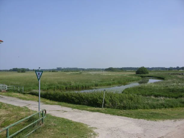
A wide view of a grassy wetland area with a winding narrow stream and a dirt path in the foreground.
A view of the grassland and old river oxbow at Vreschen-Bokel am Aper Tief.

Vreschen-Bokel am Aper Tief history and protected-area timeline

The protected area now known as Vreschen-Bokel am Aper Tief was formally designated as a Naturschutzgebiet on 21 February 2009, giving it legal status under Lower Saxon nature conservation law. The designation was assigned the code NSG WE 271 and registered internationally in the World Database on Protected Areas under WDPA-ID 389991.

Long before formal protection, the land had been shaped by centuries of interaction between natural tidal processes from the Aper Tief and human land use. The old river arms winding through the meadows reflect earlier channel patterns of the tidal stream, while the prevailing land use of mown pastures shows a long tradition of agricultural management. In the southwestern part of the area, sand extraction has more recently produced an artificial lake that has itself become part of the reserve's habitat mosaic.

Looking ahead, the responsible authorities, including the local lower nature conservation authority of the Ammerland district and the regional NLWKN agency, have planned a levee relocation and partial re-flooding of the site, marking a new chapter in the long-term hydrological management of the area.

Vreschen-Bokel am Aper Tief landscape and geographic character

The landscape of Vreschen-Bokel am Aper Tief is defined by its extreme flatness and its strong relationship with water. Elevations range only from about three metres below sea level to roughly sea level, giving the reserve a low-lying, wetland-influenced character typical of the inner coastal zone of northwestern Germany.

A defining visual and ecological motif is the network of old, sluggish arms of the Aper Tief that meander through the meadows. These former channel sections create gently curving wet depressions lined with reeds and water-loving vegetation, alternating with slightly higher, drier strips of pasture. To the southwest, the terrain is marked by an active sand quarry, where extraction has left behind a sizeable artificial lake, introducing a more open water element into an otherwise predominantly grassy landscape.

Vreschen-Bokel am Aper Tief ecosystems, habitats, and plant life

Ecologically, the reserve sits at the interface between traditionally used grassland and wetland habitat, a combination that has become scarce in the intensively farmed landscapes of northwestern Germany. The core natural value of the area lies in its wet meadows and the relict channels of the Aper Tief, which support moisture-loving plant communities and provide habitat for aquatic and semi-aquatic fauna.

The mosaic of mown pastures, wet depressions, reed-fringed old channels, and, in the southwest, the quarry lake creates a diverse small-scale habitat pattern. The planned levee relocation and re-flooding of part of the area would further extend this mosaic, allowing tidal and freshwater dynamics to shape vegetation communities more naturally and connecting the reserve more closely with the hydrological regime of the Aper Tief and the adjacent Detern-Übertiefland polder.

Vreschen-Bokel am Aper Tief wildlife and species highlights

The combination of wet meadows, slow-moving old river arms, reed fringes, and standing water in the quarry lake provides habitat for water-associated birds, amphibians, and invertebrates typical of lowland wetland complexes in northwestern Germany. The mosaic structure, with open water, marshy edges, and grassy fields in close proximity, is particularly favourable for species that use both aquatic and terrestrial habitats during their life cycles.

Although specific species records are not detailed in the available source material, the reserve's ecological setting, transitional between inland grassland and a tidal river system, gives it clear relevance for wetland-dependent birdlife and for amphibian populations, both of which are key conservation targets in such landscapes.

Vreschen-Bokel am Aper Tief conservation status and protection priorities

Vreschen-Bokel am Aper Tief was established primarily to protect a complex of species-rich meadows and pastures interlaced with old arms of the Aper Tief, a habitat combination that has become increasingly rare in the intensively managed agricultural landscapes of northwestern Lower Saxony. By formally designating the area in 2009, the regional authorities aimed to safeguard these wet grassland habitats and their associated species from further drainage, intensification, or loss.

A central conservation goal for the future is the planned relocation of the existing levee and the deliberate re-flooding of a section of the reserve. This restoration measure is intended to reconnect the site with the natural hydrological dynamics of the Aper Tief, enhance habitat diversity, and strengthen the ecological link with the neighbouring Detern-Übertiefland flood retention polder, which together cover a substantial contiguous lowland wetland complex south of the river's mouth into the Jümme.

Vreschen-Bokel am Aper Tief cultural meaning and human context

The reserve lies within the municipality of Apen in the Ammerland district, an area with a long tradition of farming on low-lying, water-influenced land. The continued use of the grasslands within the reserve as mown pastures reflects this enduring agricultural relationship with the landscape, where conservation and traditional land management are deliberately combined.

The region sits at the cultural and geographic boundary between the East Frisian coastal lowlands and the inland Ammerland, a transitional zone where tidal river systems, historic drainage works, and pastoral land use have shaped both the environment and local identity for centuries.

Top sights and standout views in Vreschen-Bokel am Aper Tief

Among the strongest distinguishing features of Vreschen-Bokel am Aper Tief are its network of old, slow-moving channels of the Aper Tief winding through traditionally managed meadows, the unusually low elevations that place parts of the reserve below sea level, and the planned restoration of more natural flooding patterns through a levee relocation.

Equally notable is its direct ecological connection to the larger Detern-Übertiefland flood retention polder to the west, which together form a substantial lowland wetland complex of considerable regional conservation significance.

Best time to visit Vreschen-Bokel am Aper Tief

As a low-lying grassland and wetland reserve in the temperate climate of northwestern Germany, Vreschen-Bokel am Aper Tief is best experienced from late spring through early autumn, when meadows are green, water levels in the old river arms are typically more visible, and wetland birdlife is most active. Wet and cool weather can make the flat terrain feel especially atmospheric, while frost periods in winter bring a quieter, more austere character to the landscape.


Monthly climate preview

Long-term monthly temperature and precipitation averages for Vreschen-Bokel am Aper Tief

Vreschen-Bokel am Aper Tief Climate Normals and Annual Weather Patterns

Representative coordinate measurements reveal the multi-year temperature and precipitation rhythm across Vreschen-Bokel am Aper Tief. Comprehensive twelve-month climate data profiles provide deeper comparative analysis for regional meteorological patterns.
Annual mean9 °C
2 °C18 °C
Jan
Feb
Mar
Apr
May13°
Jun16°
Jul18°
Aug18°
Sep14°
Oct10°
Nov
Dec
Warmest month
July

17.9 °C

Coolest month
January

1.5 °C

Wettest month
December

2.5 mm/day

Driest month
April

1.4 mm/day

Park location guide

Geography guide, regional context, and park location map for Vreschen-Bokel am Aper Tief

Vreschen-Bokel am Aper Tief park geography, regions, and map view in Germany

Understand where Vreschen-Bokel am Aper Tief sits in Germany through a broader geographic reading of the surrounding landscape, nearby location context, and its mapped position within the national park landscape.

How Vreschen-Bokel am Aper Tief fits into Germany

Germany is a federal republic in Western and Central Europe with a population of over 83 million across sixteen constituent states. It is Europe's largest economy by nominal GDP and a major global exporter and importer. The capital is Berlin, and the country borders Denmark, Poland, Czech Republic, Austria, Switzerland, France, Luxembourg, Belgium, and the Netherlands.

Wider geography shaping Vreschen-Bokel am Aper Tief in Germany

Germany is located in Western and Central Europe, spanning 357,022 km². It borders Denmark to the north, Poland and the Czech Republic to the east, Austria and Switzerland to the south, and France, Luxembourg, Belgium, and the Netherlands to the west. The country has coastlines on the Baltic Sea and North Sea to the north, with the Alps located in the southern region.

Map view of Vreschen-Bokel am Aper Tief

Use this park location map to pinpoint Vreschen-Bokel am Aper Tief in Germany, understand its exact geographic position, and read its mapped placement within the surrounding landscape more clearly.

Pigeon | © OpenStreetMap contributors

Location context for Vreschen-Bokel am Aper Tief

Ammerland

Visualizing low-lying pastures, meandering tidal channels, and wetland habitats

Vreschen-Bokel am Aper Tief Photos and Wetland Landscape Imagery

Examinations of Vreschen-Bokel am Aper Tief reveal flat wetland terrain, meandering old river arms, and species-rich grassland habitats. Visual records clarify the distinctive low-lying topography and aquatic character of this protected nature reserve in Lower Saxony.

A wide view of a grassy wetland area with a winding narrow stream and a dirt path in the foreground.

Park atlas

Compare regional protected areas and lowland nature reserves across Lower Saxony

Explore Other Parks Near Vreschen-Bokel am Aper Tief and Surrounding Wetlands

Browsing other protected areas near Vreschen-Bokel am Aper Tief reveals similar lowland river corridors and flat wetland meadows across northwestern Germany. Continuing the comparison helps place local hydrological habitats into a wider regional conservation context.
Watercolor painting of a green and pink landscape featuring a forest line with tall grasses in the foreground and soft hills in the background.
Protected landscapeNiedersachsen
About 20 km away#1 closest

East

Elmendorfer Holz: Protected Landscape and Forest Ecology in Niedersachsen, Germany

Mapping lowland forest habitats and regional protected boundaries

Elmendorfer Holz is a significant protected area and forest reserve situated north of the Zwischenahner Meer. It is defined by its near-natural oak and hornbeam canopy and dense layering of conservation status. The forest serves as a vital ecological anchor within the broader agricultural mosaic of the Ammerland district, providing a clear reference for northwestern German lowland woodland characteristics.

Area
0.285 km²
Established
2007
Nature reserveLandkreis Leer
About 28 km away#2 closest

Southwest

Vellage Nature Reserve: Protected Wetland and Ems Floodplain Geography in Landkreis Leer

A study of floodplain terrain, wetland habitats, and dike-protected ecosystems.

Vellage is a significant nature reserve in the district of Leer, characterized by its cluster of inland freshwater ponds and deadwood-rich alder woodlands. Located within the Ems floodplain landscape, the reserve functions as a critical habitat mosaic for native amphibians and aquatic species, providing a clear example of protected lowland river geography in Lower Saxony.

Area
0.084 km²
Established
2018
Watercolor painting showing coastal wetlands with mudflats, salt marshes, and distant hills under a soft light
National parkLower Saxony
About 33 km away#3 closest

Northwest

Lower Saxon Wadden Sea National Park: Protected Coastal Landscape & Geography Atlas

Explore mapped boundaries, intertidal zones, and Lower Saxony's natural terrain.

Delve into the Lower Saxon Wadden Sea National Park, a significant national park situated in Lower Saxony, Germany. This page serves as your atlas entry point for understanding its protected landscape, characterized by vast mudflats, salt marshes, and a crucial role as a migratory bird corridor. Discover the geographic context of this UNESCO World Heritage site and its unique intertidal ecosystem through structured map data and detailed landscape information.

Area
345.8 km²
Established
1986
IUCN
II
Relief
Lowland
Nature reserveLower Saxony
About 34 km away#4 closest

Southwest

Windelberg Nature Reserve: Protected Inland Dune and Heathland Mosaic in Lower Saxony

Historic sandy heath and oak woodland conservation site

Windelberg is a significant nature reserve in the Emsland region, featuring inland dunes and juniper heathland on the Hümmling glacial ridge. This area showcases a compact mosaic of dry, acidic habitats and relict oak woodland that reflects centuries of traditional land management in northwest Germany. Its status as a protected area within the Natura 2000 network highlights its importance for regional habitat conservation.

Area
0.163 km²
Established
2009
IUCN
IV
Nature reserveLandkreis Cloppenburg
About 35 km away#5 closest

Southeast

Talsperre Thülsfeld Nature Reserve: Geography and Protected Land Profile

Inland dune and wetland conservation in Landkreis Cloppenburg

Talsperre Thülsfeld functions as a protected nature reserve showcasing the traditional northwest German lowland landscape. The site contains a five kilometer long reservoir, expansive heathlands, and bog communities, offering a clear view of how glacial geography shapes modern conservation areas. Researchers and observers can examine the transition between dry sandy dunes and damp riverine floodplains within this concentrated ecological boundary.

Area
4.62 km²
Established
1957
Relief
Lowland
Climate
Temperate
Nature reserveLandkreis Emsland
About 40 km away#6 closest

Southwest

Stillgewässer bei Kluse Nature Reserve: Geographic Overview and Protected Wetland Landscape

Mapping the distinctive aquatic corridors of Landkreis Emsland.

Stillgewässer bei Kluse features a compact yet diverse mosaic of standing water pools, floating bog fringes, and oak woodlands on sandy soils. As a protected nature reserve, it functions as a crucial ecological refuge within the Emsland agricultural landscape, offering a unique opportunity to study man-made wetlands that have evolved into mature natural habitats.

Area
0.521 km²
Established
2018
Relief
Lowland
Climate
Temperate
Protected landscapeEmsland
About 41 km away#7 closest

South

Naturpark Hümmling: Geographic Overview of Emsland Protected Landscapes

Tracing glacial sand ridges, moorlands, and prehistoric cultural sites.

Naturpark Hümmling stands as a prominent protected landscape in Lower Saxony, characterized by its distinctive geest ridge, extensive raised bogs, and dense concentration of Neolithic stone monuments. The area map highlights a complex interplay of river valleys, heathland remnants, and historic cultural landmarks that define the geographical identity of this Emsland treasure.

Area
576 km²
Established
2015
Relief
Upland
Climate
Temperate
Nature reserveOldenburg
About 43 km away#8 closest

Southeast

Tannersand und Gierenberg Nature Reserve: Inland Dunes and Bog Pool Mapping

Protected sandy geest landscape within the Osenberge near Oldenburg

Tannersand und Gierenberg represents a vital nature reserve featuring an unusual inland dune system and embedded wetland Slatts. The protected area exhibits a dense contrast between coniferous dune ridges and peat-moss-rich swamps. This record details the park boundaries, landscape mosaic, and the specific terrain that classifies it as a significant protected site within Lower Saxony, Germany.

Area
0.35 km²
Established
1938

Common questions about visiting, size, designation, and location context for Vreschen-Bokel am Aper Tief

Vreschen-Bokel am Aper Tief FAQs for park facts, access, geography, and protected area context

Find quick answers about Vreschen-Bokel am Aper Tief, including protected-area facts, park geography, trail and visitor context, and how the park fits into its surrounding country and regional landscape.
MoriAtlas Explorer

Continue Your Protected Areas Search Across the Global Atlas

Deepen your exploration by continuing the structured search for national parks and protected areas worldwide. Utilize the comprehensive filtering capabilities to compare different conservation landscapes and refine your understanding of global park geography. Discover more about the distribution and characteristics of protected natural areas.

Global natural geography