

Mori Atlas logo
Natural monumentVypálenky

Discover the lowland floodplain terrain, habitat patterns, and aquatic biodiversity of this protected riverine environment.

Vypálenky Natural Monument: Mapped Geography and Protected Wetland Ecosystems in South Moravia

(Přírodní památka Vypálenky)

Vypálenky serves as a vital protected natural monument within the Morava River valley, featuring a low-lying floodplain landscape of wet meadows, reedbeds, and shallow pools. This specialized habitat mosaic sustains critical populations of amphibians, including the European fire-bellied toad and the Danube crested newt, while functioning as an integral component of the larger Natura 2000 protected network in the South Moravian region.

wetlandfloodplainamphibiansfire-bellied toadDanube crested newtaquatic invertebrates
A stylized vector illustration showing a wetland scene with a large cut tree stump in the foreground, cattails, calm water, green trees, and purple mountains in the distance.

Vypálenky

Natural monument

Park overview

Structured park overview, official facts, and landscape profile for Vypálenky

Vypálenky park facts, protected area profile, and essential visitor context

Review the core facts for Vypálenky, including designation, size, terrain, visitor scale, habitats, and operating context in one park-focused overview.

About Vypálenky

Vypálenky occupies a quiet but ecologically vital position within the wider floodplain landscape of the Morava River, where lowland forests, meadows, and standing waters form a continuous network of habitats supporting some of Central Europe's most threatened wetland species. Although its official area of roughly 65 hectares makes it a compact site, the value of Vypálenky lies in the density and rarity of the species it shelters rather than in its physical extent.

The protected area lies in the southeastern part of Moravský Písek, just north of Veselí nad Moravou. It sits within the level, low-elevation terrain typical of the South Moravian floodplain, where the Morava River has historically shaped a mosaic of wet meadows, reed stands, oxbows, and shallow pools. This combination of features creates ideal conditions for amphibians, aquatic invertebrates, and wetland birds that have lost much of their former range across Central Europe.

What sets Vypálenky apart from many other regional wetland sites is the simultaneous occurrence of several critically endangered and European-protected species. The fire-bellied toad and Danube crested newt are both species of European conservation concern, and their strong populations here help reinforce the broader Moravian floodplain as a national stronghold for these animals. The site's inclusion in the Natura 2000 network and the Bzenecká Doubrava – Strážnické Pomoraví protected area reflects the recognition that Vypálenky's habitats are inseparable from the much larger ecosystem that surrounds them.

In practical terms, the protected area functions as a living reservoir of floodplain biodiversity. Its shallow standing waters and soft sediments support the life cycles of amphibians and rare invertebrates, while its reed-fringed edges and open water provide breeding habitat and seasonal refuge for wetland birds moving along the Morava corridor.

Quick facts and research context for Vypálenky

Vypálenky is a Czech natural monument (přírodní památka), corresponding to IUCN Category IV, a habitat and species management area. It was designated on 1 January 2014 by the Regional Authority of the South Moravian Region.

The site lies in the Hodonín District of the South Moravian Region, in the southeastern part of the village of Moravský Písek, between the towns of Veselí nad Moravou and Strání along the I/54 road corridor. With an area of about 65 hectares and an elevation of just 170 to 174 meters above sea level, it represents one of the lowest-lying protected wetland sites in the region, situated within the Morava River floodplain.

Protection and recognition

Documented terrestrial boundaries and Natura 2000 conservation designations

Vypálenky Protection Status and International Recognition Records

Vypálenky maintains documented terrestrial protection status supported by official Natura 2000 records. International recognition sources outline the established boundaries and administrative scope for this conservation area.

International recognition

Protection details

Protection scope
Terrestrial
Transboundary protection
No
Park context

Deeper park guide and search-rich context for Vypálenky

Vypálenky history, landscape, wildlife, and travel context

Explore Vypálenky through its history, landscape character, ecosystems, wildlife, conservation priorities, cultural context, and seasonal travel timing in a structured park guide built for atlas discovery and search intent.

Why Vypálenky stands out

Vypálenky is best known for hosting one of the most important lowland wetland amphibian assemblages in the Czech Republic, especially strong populations of the European fire-bellied toad (Bombina bombina) and the rare Danube crested newt (Triturus dobrogicus), the latter being considered critically endangered nationally. The site is equally valued for its invertebrate fauna, which includes several critically endangered species such as the spring tadpole shrimp (Lepidurus apus) and the giant water beetle Cybister lateralimarginalis, alongside the marsh frog and the large water beetle Hydrophilus atterimus. These concentrations of rare wetland species in a relatively compact floodplain segment give Vypálenky an outsized conservation significance.
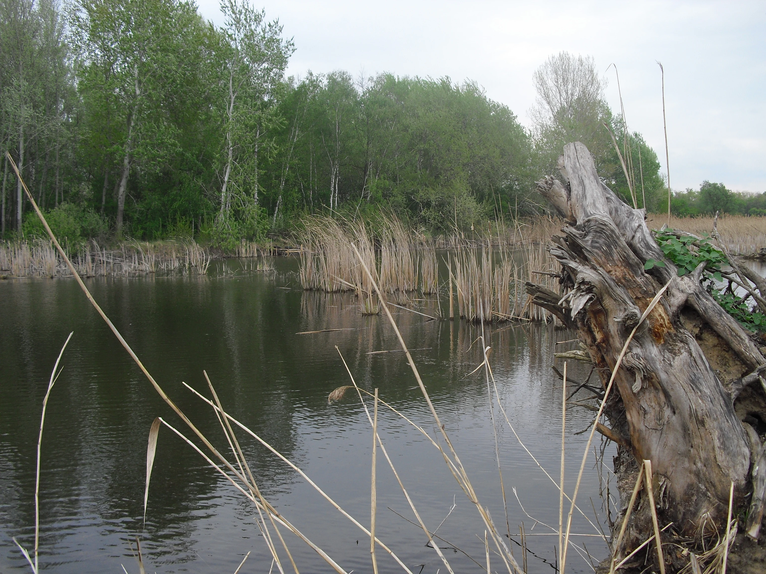
A wetland landscape showing a calm body of water with reeds and a large dead tree trunk in the foreground, backed by a line of green trees under an overcast sky.
A view of the Vypálenky nature monument wetland, featuring a calm body of water, reeds, and a large piece of driftwood in the foreground.

Vypálenky history and protected-area timeline

Vypálenky was formally designated as a protected natural monument (přírodní památka) on 1 January 2014 by the Regional Authority of the South Moravian Region, classifying it as an IUCN Category IV area focused on the conservation of a particular species or habitat.

Its recognition as a protected site grew out of broader European conservation efforts in the Morava floodplain, anchored by the establishment of the Bzenecká Doubrava – Strážnické Pomoraví Natura 2000 site, which encompasses nearly twelve thousand hectares of interconnected wetland, meadow, and forest habitats. The inclusion of Vypálenky within this larger Natura 2000 Site of Community Importance and Bird Area places the site within a transboundary framework designed to preserve the ecological integrity of the lower Morava River valley.

Vypálenky landscape and geographic character

The landscape of Vypálenky is defined by the flat, low-lying terrain of the Morava River floodplain, where elevations barely exceed 170 meters above sea level. The site consists of wet meadows, reedbeds, shallow pools, and slow-moving channels characteristic of a mature lowland river valley.

This type of terrain, gentle and waterlogged, contrasts sharply with the more elevated landscapes elsewhere in the South Moravian Region. The flat floodplain surface, combined with periodic flooding and high groundwater, has shaped a habitat mosaic of small open waters interspersed with marsh vegetation and damp grassland, providing the structural diversity on which the site's amphibians, invertebrates, and birds depend.

Vypálenky ecosystems, habitats, and plant life

Vypálenky protects a wetland biotope of the Morava River floodplain, one of the most ecologically distinctive habitat types in the Czech Republic. The site preserves a complex of habitats including shallow standing waters, marshland fringes, and damp meadows that together create breeding, feeding, and shelter conditions for a remarkable range of species.

Within the Czech context, the floodplain ecosystems of the Morava River have long been recognized for their ecological richness, and Vypálenky captures a representative segment of these habitats. Its small footprint conceals an unusually high biodiversity density, with the intermixing of aquatic and semi-aquatic habitats supporting both resident species and seasonal migrants. The site plays an important role in maintaining habitat connectivity across the wider floodplain, serving as a stepping stone within the broader ecological corridor that extends along the Morava River.

Vypálenky wildlife and species highlights

The wildlife profile of Vypálenky is dominated by amphibians and aquatic invertebrates, the groups for which the site receives its strongest protection designations. The European fire-bellied toad (Bombina bombina), a species of European conservation concern, breeds here in robust numbers, while the critically endangered Danube crested newt (Triturus dobrogicus) represents one of the most important regional strongholds.

The invertebrate fauna is equally significant. The spring tadpole shrimp (Lepidurus apus), a critically endangered specialist of temporary pools, occurs alongside the large diving beetle Cybister lateralimarginalis, the marsh frog (Rana ridibunda), and the great water beetle Hydrophilus atterimus, all of which are classified as critically endangered within the Czech Republic.

The site also serves as a breeding area and migratory stopover for wetland birds using the Morava floodplain corridor. The combination of open water, reeds, and adjacent meadows provides nest sites, foraging areas, and resting habitat for species that depend on lowland wet habitats during both the breeding season and seasonal migration.

Vypálenky conservation status and protection priorities

Vypálenky is one of the cornerstones of wetland conservation in the South Moravian floodplain. Its formal status as a přírodní památka (natural monument) reflects the presence of multiple species of European and national conservation concern, and its designation as part of the Bzenecká Doubrava – Strážnické Pomoraví Natura 2000 site extends that protection into a broader European framework.

The site's ecological value is heightened by the loss of similar wetland habitats elsewhere in Central Europe. The rare combination of amphibians and invertebrates found at Vypálenky makes it an important reservoir for species that have disappeared from many of their former localities, and its protection is closely tied to the preservation of natural hydrological processes in the Morava floodplain, including seasonal flooding and groundwater dynamics that sustain the wetland biotope.

Top sights and standout views in Vypálenky

Vypálenky's strongest distinguishing qualities are the exceptional concentration of rare amphibians, including the European fire-bellied toad and the critically endangered Danube crested newt, and the unusually rich assemblages of rare aquatic invertebrates such as the spring tadpole shrimp and large diving beetles.

Equally important is the site's location within the large Bzenecká Doubrava – Strážnické Pomoraví Natura 2000 area, which embeds Vypálenky within an almost twelve-thousand-hectare network of protected floodplain habitats along the Morava River.

Best time to visit Vypálenky

As a lowland wetland, Vypálenky is most expressive ecologically in spring, when rising water levels and warming temperatures activate amphibian breeding in its shallow pools and maximize the visibility and vocal activity of fire-bellied toads and Danube crested newts. Late spring and early summer also bring peak activity among the site's rare aquatic invertebrates.

For birdwatchers, the broader Morava floodplain corridor is most rewarding during spring migration and the early summer breeding season, when waterbirds use the site's pools, reedbeds, and wet meadows as nesting and feeding habitat. Autumn offers quieter observation conditions and the possibility of seeing migratory waterbirds using the floodplain as a stopover before moving further south.


Monthly climate preview

Long-term representative temperature and precipitation patterns for Vypálenky

Vypálenky Climate Normals and Monthly Weather Records

Vypálenky records measured monthly temperature variations and precipitation averages sampled across a representative coordinate from 1991 to 2020. The complete climate dataset details full twelve-month temperature swings and precipitation distributions for deeper environmental analysis.
Annual mean9 °C
-3 °C20 °C
Jan-3°
Feb-1°
Mar
Apr
May14°
Jun18°
Jul20°
Aug20°
Sep15°
Oct
Nov
Dec-2°
Warmest month
July

20.3 °C

Coolest month
January

-3.4 °C

Wettest month
July

2.6 mm/day

Driest month
February

1.3 mm/day

Park location guide

Geography guide, regional context, and park location map for Vypálenky

Vypálenky park geography, regions, and map view in Czechia

Understand where Vypálenky sits in Czechia through a broader geographic reading of the surrounding landscape, nearby location context, and its mapped position within the national park landscape.

How Vypálenky fits into Czechia

Czech Republic is a landlocked Central European country with a population of approximately 10.9 million people. The nation was established as an independent state on January 1, 1993, following the dissolution of Czechoslovakia. Its capital and largest city is Prague, with other major urban centers including Brno, Ostrava, Plzeň, and Liberec.

Wider geography shaping Vypálenky in Czechia

The Czech Republic is a landlocked country in Central Europe. It is bordered by Germany to the west, Austria to the south, Poland to the northeast, and Slovakia to the southeast. The landscape is predominantly hilly, with the territory covering 78,871 square kilometers.

Map view of Vypálenky

Use this park location map to pinpoint Vypálenky in Czechia, understand its exact geographic position, and read its mapped placement within the surrounding landscape more clearly.

Pigeon | © OpenStreetMap contributors

Location context for Vypálenky

Jihomoravský kraj
Recorded earthquake history

View the Historical Earthquake Catalogue for the Vypálenky Natural Monument

Access a detailed, historical record of seismic events documented near the Vypálenky wetland area. This MoriAtlas catalogue provides structured data on event timing, magnitude, and proximity to this protected South Moravian landscape to assist in geographic and environmental research.

Vypálenky Earthquake History

Catalogued events

1 event

Strongest magnitude

Magnitude 3

Most recent event

Sep 19, 2003

This history includes earthquakes recorded inside the park or within 50 km of its borders

Explore detailed imagery of the lowland floodplain terrain, wet meadows, and aquatic habitats

Vypálenky Photos and Landscape Scenery: Visualizing the Protected Wetland Environment

Visual records capture the flat floodplain terrain and shallow wetland pools that define Vypálenky within the Morava River valley. Examining these protected area views reveals the unique habitat mosaic supporting rare amphibian populations across the region.

A wetland landscape showing a calm body of water with reeds and a large dead tree trunk in the foreground, backed by a line of green trees under an overcast sky.

Park atlas

Compare adjacent wetland reserves and regional floodplain habitats across South Moravia

Explore Other Parks Near Vypálenky and Surrounding Protected Landscapes

Continue browsing parks near Vypálenky to examine similar lowland wetland ecosystems and protected floodplain terrain along the Morava River valley. Expanding the geographic scope helps connect isolated reserves with wider regional conservation networks.
Natural monumentJihomoravský kraj
About 2.7 km away#1 closest

Southwest

Vojenské cvičiště Bzenec Natural Monument in Jihomoravský kraj: A Protected Sand-Dune Habitat

Mapped protected areas and sandy steppe geography in the South Moravian Region

Vojenské cvičiště Bzenec preserves an unusual open sandy landscape formed by aeolian processes, now serving as a critical refuge for rare insects and dry-grassland plants. Its distinct geography of low dunes and scattered pine groves provides a vital example of steppe-like habitat conservation in South Moravia, highlighting the ecological value of former military lands.

Area
0.368 km²
Established
1994
IUCN
IV
Relief
Lowland
A watercolor painting showing a stylized, panoramic landscape of rolling green hills, trees, and distant soft mountains.
Natural monumentZlínský kraj
About 8.9 km away#2 closest

Northwest

Medlovický lom Natural Monument: Geomorphological and Geological Atlas of Zlínský Kraj

Protected geological profile and amphibian habitat in eastern Moravia

Explore the geological heritage of Medlovický lom, a protected site defined by its extensive exposure of fired clay known as porcelanite. This former quarry offers a window into the geomorphological history of the Vážanská vrchovina, contrasting its artificial rock faces with the surrounding agricultural terrain and hills of the Moravian region. The site acts as both an educational geological record and a small-scale sanctuary for aquatic wildlife, maintaining its status as a landmark of local earth science.

Area
0.011 km²
Established
1997
IUCN
III
Relief
Upland
Natural monumentJihomoravský kraj
About 14 km away#3 closest

East

Miliovy louky Natural Monument: South Moravia Protected Grassland Geography

Mapping the xerothermic steppe and meadow landscape

Miliovy louky is a protected natural monument located in the Jihomoravský kraj region, noted for its surviving patch of semi-natural dry steppe vegetation. This compact reserve offers a distinct look at the region's historical open terrain, providing a critical haven for dryland flora and butterfly species amidst a backdrop of managed agricultural farmland.

Area
0.084 km²
Established
2014
IUCN
IV
Relief
Upland
Natural monumentJihomoravský kraj
About 19 km away#4 closest

Southeast

Velický hliník Natural Monument: A Case Study in Carpathian Landscape Restoration

Analyzing the geography of South Moravian protected clay habitats

Deep dive into the geomorphology and protected landscape of Velický hliník in the Czech Republic. This site of community importance demonstrates how former clay extraction zones transform into complex wetland mosaics, supporting specialized biodiversity within the Žalustín Highlands.

Area
0.053 km²
Established
2013
IUCN
IV
Relief
Upland
Watercolor illustration of a lush, green landscape featuring rolling hills and grassy meadows under a pale sky.
Nature reserveZlín District
About 27 km away#5 closest

Northeast

Na letišti Nature Reserve: Mapped Floodplain Landscapes in the Zlín District

A rare oxbow wetland refuge in Eastern Czechia

Located in the Zlín District, Na letišti is a protected natural monument formed from a regulated meander of the Morava River. This site functions as an isolated aquatic refuge, featuring a rich community of beetles and wetland flora that define the character of this lowland floodplain landscape within the Czech Republic.

Area
0.027 km²
Established
1956
IUCN
IV
Relief
Lowland
Watercolor painting of green rolling hills and small groves of trees, with a minimalist, airy style.
Nature reserveZlín Region
About 29 km away#6 closest

East

Mechnáčky Nature Reserve: Protected Meadow Biodiversity in the Zlín Region of the Czech Republic

Orchid-rich grasslands and managed Carpathian meadow landscapes

Mechnáčky represents an important nature reserve defined by its remnant flower-rich meadows and diverse invertebrate habitats. Situated in the Zlín Region, this site provides a focused look at the conservation of traditional Carpathian landscapes, including calcareous grasslands and spring-fed slopes that define the unique botanical character of this Czech protected area.

Area
0.109 km²
Established
1982
IUCN
IV
Relief
Upland
Natural monumentZlín Region
32 km away#7 closest

Northeast

Uhliska Natural Monument: Protected Stream Valley Geography and Moravian Habitats

A diverse protected wetland and meadow mosaic in the Zlín Region.

The Uhliska natural monument protects a narrow, meandering valley corridor along the Černý potok stream in eastern Moravia. This high-value habitat mosaic features wet Cirsium meadows, broad-leaved dry grasslands, and ash alder gallery forests. The site provides a critical refuge for protected butterflies of European importance, serving as an exemplary model of small-scale landscape conservation in the Zlín Region.

Area
0.143 km²
Established
1991
IUCN
IV
Relief
Upland
Protected landscapeCzechia
About 32 km away#8 closest

West

Přírodní park Ždánický les: Exploring Protected Woodlands and Moravian Carpathian Landscapes

Regional woodland geography and floodplain meadow systems

Přírodní park Ždánický les spans nearly 182 square kilometers of rolling terrain across the Vyškov and Hodonín districts. This protected landscape preserves extensive broadleaf forests, including mature beech and oak stands, while maintaining unique floodplain meadows that serve as essential habitat corridors within the wider Moravian Carpathian region.

Area
181.89 km²
Established
1996
Relief
Upland
Scope
Terrestrial

Common questions about visiting, size, designation, and location context for Vypálenky

Vypálenky FAQs for park facts, access, geography, and protected area context

Find quick answers about Vypálenky, including protected-area facts, park geography, trail and visitor context, and how the park fits into its surrounding country and regional landscape.
MoriAtlas Explorer

Continue Your Protected Areas Search Across the Global Atlas

Deepen your exploration by continuing the structured search for national parks and protected areas worldwide. Utilize the comprehensive filtering capabilities to compare different conservation landscapes and refine your understanding of global park geography. Discover more about the distribution and characteristics of protected natural areas.

Global natural geography