
Mori Atlas logo
Nature reserveWald nordwestlich Boksee

Mapping the glacial moraine terrain and protected forest boundaries in Schleswig-Holstein

Wald nordwestlich Boksee Nature Reserve: A Detailed Geographic Overview of Ancient Woodlands

(FFH-Gebiet Wald nordwestlich Boksee)

Wald nordwestlich Boksee is a protected nature reserve in Schleswig-Holstein, defined by its ancient deciduous woodland ecosystems and glacial moraine topography. This geographic entry tracks the forest structure, including the historic Knick hedgerow boundaries and the hydrologic connection to the surrounding moorland. Visitors and researchers can analyze the intersection of private and state-managed conservation zones that define this ecologically significant northern German site.

Deciduous ForestNatura 2000Ancient WoodlandBeech ForestSchleswig-HolsteinHabitat Directive
A flat-style digital illustration showing a valley with green meadows, pine forests, a waterfall cascading down a cliff, and a river flowing through the center under a pastel sky.

Wald nordwestlich Boksee

Nature reserve

Park overview

Structured park overview, official facts, and landscape profile for Wald nordwestlich Boksee

Wald nordwestlich Boksee park facts, protected area profile, and essential visitor context

Review the core facts for Wald nordwestlich Boksee, including designation, size, terrain, visitor scale, habitats, and operating context in one park-focused overview.

About Wald nordwestlich Boksee

Wald nordwestlich Boksee, often recognized by its older cartographic name Gehege Boksee, stands out as a dedicated Natura 2000 protected zone in the northern German countryside. The site encompasses a historically continuous forest that has maintained its woodland character for at least 150 years, functioning as a vital refuge for native deciduous species in an agricultural landscape. The total area spans approximately 25 hectares, making it a concentrated but highly structured ecological reserve.

The terrain is shaped by the Weichselian glaciation, featuring gently undulating hills resting on a glacial till base. Elevations range from roughly 47 meters in the northern lowlands to 59.8 meters above sea level at the highest southeastern crests. This mild topography supports a network of moist soils and drainage channels, anchored by the Speckhörner Bach on the western boundary. This stream flows through a succession of local waterways, eventually joining the Schwentine river system and reaching the Baltic Sea.

Ecologically, the site's primary significance lies in its classification under several specific European habitat types, particularly various beech forest ecosystems and mixed oak-hornbeam forests. The eastern sector is officially designated as natural forest, meaning active forestry is prohibited to allow for undisturbed ecological succession. This dual structure of protected ancient woodland and natural forest regeneration establishes the area as an important reference site for forest ecology in the East Holstein region.

Quick facts and research context for Wald nordwestlich Boksee

Wald nordwestlich Boksee is a 25-hectare Natura 2000 protected zone situated in the Plön district of Schleswig-Holstein. The entire reserve is enveloped by a traditional Knick hedgerow and features terrain shaped by the Weichselian glaciation, with elevations ranging from 47 to 59.8 meters above sea level. The property contains mature deciduous stands, a mix of protected European beech and oak forest types, and designated natural forest sections managed by the Schleswig-Holstein state forestry service.

Protection and recognition

Documented terrestrial protection history and Natura 2000 recognition records

Wald nordwestlich Boksee Protection Status and International Recognition Data

Wald nordwestlich Boksee maintains a documented terrestrial protection status established in 2010 alongside verified Natura 2000 recognition records. Structured administrative facts outline the official designation history and international recognition sources associated with this protected area.

International recognition

Protection details

Protection scope
Terrestrial
Designated year
2010
Transboundary protection
No
WDPA ID
555517898
Park context

Deeper park guide and search-rich context for Wald nordwestlich Boksee

Wald nordwestlich Boksee history, landscape, wildlife, and travel context

Explore Wald nordwestlich Boksee through its history, landscape character, ecosystems, wildlife, conservation priorities, cultural context, and seasonal travel timing in a structured park guide built for atlas discovery and search intent.

Why Wald nordwestlich Boksee stands out

The site is best known for its continuous cover of ancient deciduous woodland, a rare feature in the modern agricultural landscape of Schleswig-Holstein. It serves as a protected example of specific European beech forest habitats, including Hainsimsen-Buchenwälder and Waldmeister-Buchenwälder, as well as mixed oak-hornbeam forests and alder-ash softwood floodplains. Its strict conservation zoning in the eastern half demonstrates a commitment to undisturbed natural forest succession.
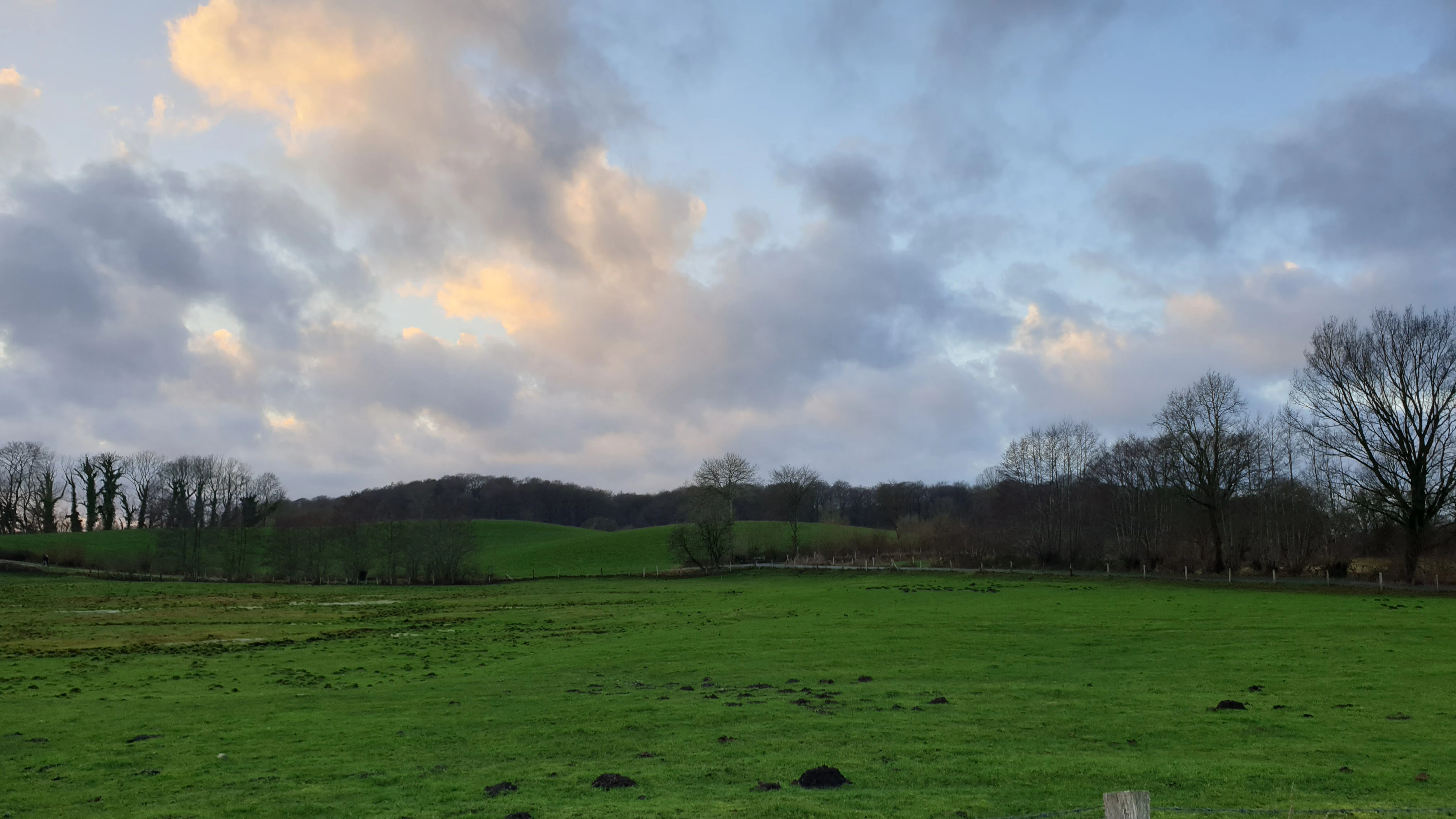
A wide landscape view of green grassy fields in the foreground leading to a line of deciduous trees and a hilly horizon under a cloudy sky.
A view of the landscape and forest edges near the nature area northwest of Boksee.

Wald nordwestlich Boksee history and protected-area timeline

The history of this woodland stretches back well beyond modern conservation efforts, as historical maps from 1877 already identify the site as an enclosed deciduous forest under the name Gehege Wehrbröken. This continuous forest coverage has allowed for the development of mature, ecologically complex habitats, including oak, beech, and alder stands that now exceed 150 years of age.

Modern conservation history began in May 2004 when the state environmental agency of Schleswig-Holstein developed the initial Natura 2000 standard data form for the site. In September 2004, it was formally proposed as a Site of Community Importance. The European Union officially confirmed this status in November 2007. The classification was finalized on a national level in January 2010, when the area was legally secured as a Special Area of Conservation under German federal and state nature conservation laws.

To guide the preservation of the site, a comprehensive management plan was developed and officially published on July 28, 2016. The plan outlines specific actions, such as reducing non-native conifer plantations, maintaining local water tables through carefully managed drainage structures, and encouraging the accumulation of deadwood to support forest-floor invertebrates and fungi. The European Commission mandates that monitoring of these conservation efforts be conducted on a six-year cycle to ensure the long-term viability of the protected habitats.

Wald nordwestlich Boksee landscape and geographic character

The physical landscape of Wald nordwestlich Boksee is defined by its glacial origins and subtle topographic shifts. The entire reserve sits upon a Grundmoräne, or basal moraine, a depositional landform created by the Weichselian ice sheet. This geomorphological foundation produces a gently rolling terrain rather than dramatic peaks, punctuated by a prominent boundary embankment that bisects the forest in a roughly northeastern trajectory.

A defining visual and structural feature is the traditional Knick, a thick regional hedgerow made of earth and shrubs that completely encircles the forest. This historical boundary marker not only protects the woodland from surrounding agricultural lands but also creates a unique microclimate along the forest margin. The highest point in the reserve sits in the southeast at 59.8 meters above sea level, while the lowest stretches across the north at 47 meters.

Hydrologically, the area is tied to a network of small regional streams. The Speckhörner Bach acts as the natural western border of the site, collecting water from the forest floor and channeling it toward the Schwentine estuary. Surrounding the protected zone are additional ecological interfaces, including the Kleinflintbeker Moor to the northwest and the drained moorland of the Alter Moorsee to the north, illustrating how the forest acts as a central hub within a broader wetland and woodland corridor.

Wald nordwestlich Boksee ecosystems, habitats, and plant life

The nature of the reserve is overwhelmingly defined by its dense, mature deciduous forest cover. Unlike the conifer-heavy plantations common across much of modern Germany, this site is dedicated to preserving native broadleaf ecosystems. The habitat classification notes that roughly three-quarters of the total area is mapped as protected European forest habitat types.

The specific habitat types protected here include the Hainsimsen-Buchenwälder, which are woodrush-beech forests; the Waldmeister-Buchenwälder, or sweet woodruff-beech forests; and the Sternmieren-Eichen-Hainbuchenwälder, representing mixed oak and hornbeam forests. A smaller portion of the site features priority habitat Erlen-Eschen- und Weichholzauenwälder, which are alder and ash floodplain forests dependent on high soil moisture. In areas not mapped to these specific habitat types, the soil supports moisture-loving birch and alder swamp woodland communities.

The age structure of the forest is notably old-growth in character, particularly within the state-owned eastern section, which is managed strictly as a natural forest reserve. Here, ecological processes are allowed to unfold naturally, resulting in significant volumes of standing and fallen deadwood. This deadwood is a critical component of forest biodiversity, providing essential habitat for saproxylic insects, specialized fungi, and various cavity-nesting species.

Wald nordwestlich Boksee conservation status and protection priorities

Conservation efforts at Wald nordwestlich Boksee are highly structured under the legal frameworks of the European Union's Habitats Directive and German national nature protection laws. As an official Special Area of Conservation, any alteration to the site requires strict adherence to preservation goals established by the regional environmental ministry.

Land ownership plays a central role in the site's management strategy. The eastern half is owned by the Schleswig-Holsteinische Landesforsten, the state forestry service, which has designated the area strictly as a natural forest. In this zone, all active forestry and timber harvesting are entirely prohibited to foster undisturbed ecological succession. Conversely, the western half is fragmented among multiple private owners, requiring tailored conservation agreements to manage the landscape effectively.

Active management interventions are minimal and highly targeted. Conservation managers focus on gradually removing non-native conifer trees to expand the footprint of native deciduous species. They also work diligently to maintain the historical hydraulic system by managing small dams in the drainage ditches, ensuring the sensitive floodplain habitats remain adequately hydrated. Regular monitoring cycles evaluate the success of these initiatives, tracking changes in habitat quality, tree health, and the regeneration of native understory plants.

Top sights and standout views in Wald nordwestlich Boksee

This protected woodland offers a concentrated view of Central European forest heritage, showcasing pristine examples of beech and oak ecosystems that have been continuously forested for over a century. Its compact footprint allows for an intense ecological density rarely seen in larger, mixed-use landscapes. The contrast between the actively managed private western section and the strictly protected natural forest in the east provides a clear demonstration of varied conservation approaches within a single geographic boundary.

Best time to visit Wald nordwestlich Boksee

Late spring and early autumn are typically the most rewarding seasons to visit woodlands in this region of northern Germany. During the late spring, the forest floor comes alive with blooming native wildflowers, and the deciduous canopy fills out completely, creating a shaded, humid environment ideal for observing rich moss and fern growth. In the early autumn, the changing colors of the beech and oak leaves provide a striking visual contrast against the dark green of the surrounding conifers and moorland edges. Winter visits offer stark views of the structural complexity of the old-growth trees and the significance of standing deadwood.

Monthly climate preview

Long-term representative temperature and precipitation averages recorded at coordinates in Schleswig-Holstein

Wald nordwestlich Boksee Climate Normals and Monthly Weather Data

Temperature and precipitation data collected at a representative coordinate inside Wald nordwestlich Boksee show measured long-term annual rhythms from 1991 to 2020. Reviewing the complete monthly profile provides detailed context on average minimum and maximum temperatures across the full twelve-month span.
Annual mean9 °C
1 °C18 °C
Jan
Feb
Mar
Apr
May12°
Jun15°
Jul18°
Aug18°
Sep14°
Oct10°
Nov
Dec
Warmest month
August

17.6 °C

Coolest month
January

1.1 °C

Wettest month
August

2.5 mm/day

Driest month
April

1.3 mm/day

Park location guide

Geography guide, regional context, and park location map for Wald nordwestlich Boksee

Wald nordwestlich Boksee park geography, regions, and map view in Germany

Understand where Wald nordwestlich Boksee sits in Germany through a broader geographic reading of the surrounding landscape, nearby location context, and its mapped position within the national park landscape.

How Wald nordwestlich Boksee fits into Germany

Germany is a federal republic in Western and Central Europe with a population of over 83 million across sixteen constituent states. It is Europe's largest economy by nominal GDP and a major global exporter and importer. The capital is Berlin, and the country borders Denmark, Poland, Czech Republic, Austria, Switzerland, France, Luxembourg, Belgium, and the Netherlands.

Wider geography shaping Wald nordwestlich Boksee in Germany

Germany is located in Western and Central Europe, spanning 357,022 km². It borders Denmark to the north, Poland and the Czech Republic to the east, Austria and Switzerland to the south, and France, Luxembourg, Belgium, and the Netherlands to the west. The country has coastlines on the Baltic Sea and North Sea to the north, with the Alps located in the southern region.

Map view of Wald nordwestlich Boksee

Use this park location map to pinpoint Wald nordwestlich Boksee in Germany, understand its exact geographic position, and read its mapped placement within the surrounding landscape more clearly.

Pigeon | © OpenStreetMap contributors

Location context for Wald nordwestlich Boksee

PlönSchleswig-Holstein

Visualizing the ancient deciduous woodland, glacial moraine terrain, and habitat character of Schleswig-Holstein

Wald nordwestlich Boksee Photos, Landscape, and Protected Scenery

Visual documentation captures the ancient beech canopy, rolling moraine terrain, and traditional hedgerow boundaries defining Wald nordwestlich Boksee. Photographic records provide clear visual context for understanding the protected forest habitats and ecological layout of the reserve.

A wide landscape view of green grassy fields in the foreground leading to a line of deciduous trees and a hilly horizon under a cloudy sky.

Park atlas

Compare surrounding regional nature reserves and connected woodland habitats

Other Parks Near Wald nordwestlich Boksee and Related Protected Landscapes

Continue exploring other parks near Wald nordwestlich Boksee to compare similar deciduous woodland habitats across the surrounding region. Analyzing adjacent protected areas provides deeper insight into local glacial terrain and regional conservation networks.
A horizontal watercolor painting depicting a soft, ethereal landscape with green trees on the left and right, a winding stream in the center, and pale rolling hills in the background against a light, misty sky.
Nature reserveSchleswig-Holstein
About 15 km away#1 closest

Southwest

FFH-Gebiet Wennebeker Moor und Langwedel Nature Reserve: Geographic and Landscape Atlas

Protected mire and heathland complex in Schleswig-Holstein

The FFH-Gebiet Wennebeker Moor und Langwedel nature reserve encompasses a complex mosaic of wet and dry heath, quaking bogs, and Nardus grasslands. This site is distinguished by its unique integration of conservation obligations with active military land use, creating a rare habitat environment within a gently rolling morainal landscape.

Area
2.3 km²
Established
2004
Relief
Lowland
Climate
Temperate
A watercolor painting showing a soft panoramic view of green hills and a winding stream, with distant pale mountains in the background.
Nature reserveSchleswig-Holstein
About 24 km away#2 closest

West

FFH-Gebiet Wehrau und Mühlenau Nature Reserve and River Corridor Geography

Protected riparian habitat in Schleswig-Holstein

Spanning over 246 hectares, this nature reserve protects a vital sequence of lowland streams, including the Mühlenau and Wehrau rivers. The area serves as an important refuge for rare mollusk species and aquatic wildlife, while preserving the integrity of a glacial tunnel valley geotope. This structured map view highlights the connectivity of wetlands, forests, and stream habitats that define the local landscape.

Area
2.46 km²
Established
2004
Relief
Lowland
Climate
Temperate
Nature reserveSchleswig-Holstein
25 km away#3 closest

West

Wälder der nördlichen Itzehoer Geest: Protected Area and Forest Landscape Atlas

Natura 2000 ancient woodland in Schleswig-Holstein

Explore the geography of Wälder der nördlichen Itzehoer Geest, featuring four historical forest tracts across glacial moraines. This protected area highlights Atlantic acid beech forests and floodplain habitats, preserving centuries-old woodland continuity within the broader Schleswig-Holstein landscape.

Area
7.11 km²
Established
2004
Relief
Upland
Climate
Temperate
Nature reserveSchleswig-Holstein
26 km away#4 closest

Southeast

Tarbeker Moor Nature Reserve and Glacial Peatland Basin Geography

A restored wetland landscape in Schleswig-Holstein, Germany

Tarbeker Moor functions as a crucial nature reserve that showcases the successful rewetting of a former industrial peatland. Located in a shallow glacial meltwater channel north of Bad Segeberg, the park offers a distinct study in landscape recovery, featuring a dense mosaic of open water, floating vegetation, and diverse amphibian habitats.

Area
1.31 km²
Established
2004
A watercolor painting showing a flat, marshy shoreline leading to a calm lake, with rolling hills in the background and soft, muted tones of green and yellow.
Protected areaSchleswig-Holstein
About 28 km away#5 closest

Northwest

FFH-Gebiet Wittensee und Flächen angrenzender Niederungen Protected Area Geography

Glacial lake and lowland landscape context in Schleswig-Holstein.

Explore the physical geography of the FFH-Gebiet Wittensee und Flächen angrenzender Niederungen, encompassing the Wittensee glacial basin and its neighboring wetland corridors. This record provides a detailed look at the site's habitat mosaic, including calcareous fens and riparian woodlands situated along the Habyer Au and Schirnauer Au streams.

Area
12.2 km²
Established
2004
Relief
Lowland
Climate
Temperate
Protected landscapeSchleswig-Holstein
About 28 km away#6 closest

Southeast

Naturpark Holsteinische Schweiz: Geographic Atlas of a Northern German Protected Landscape

Lake-dense glacial regions and forest habitats in Schleswig-Holstein.

Spanning 75,000 hectares across the districts of Ostholstein, Plön, and Segeberg, Naturpark Holsteinische Schweiz offers a rich look at a classic post-glacial landscape. This structured overview details the park's intricate network of lakes, winding streams like the Schwentine, and restored peatlands that support essential waterbird habitats. Gain a deeper understanding of the park's topography, from the Bungsberg ridges to the expansive lowland depressions that define this region.

Area
753.28 km²
Established
1986
Relief
Upland
Climate
Temperate
A horizontal watercolor painting depicting a soft, rolling landscape with green trees in the foreground, a light-colored meadow or field in the midground, and distant muted hills in the background.
Protected areaSchleswig-Holstein
About 36 km away#7 closest

Northwest

FFH-Gebiet Wälder der Hüttener Berge: Protected Area and Glacial Moraine Atlas

Ancient beech woodland mosaics in Schleswig-Holstein.

FFH-Gebiet Wälder der Hüttener Berge comprises eleven distinct state forest parcels stretching across northern Germany. This atlas entry details the site's rich habitat structure, including rare Atlantic beech forests, transition mires, and glacial soils, providing essential geographic context for this vital Natura 2000 protected territory.

Area
4.16 km²
Established
2004
Relief
Upland
Climate
Temperate
Natural monumentSchleswig-Holstein
About 37 km away#8 closest

South

Kalkberghöhle Natural Monument: Geological Profile and Protected Karst Landscape in Schleswig-Holstein

Mapping a unique gypsum cave and biological refuge

Located in Bad Segeberg, Kalkberghöhle represents a significant karst formation emerging from the young moraine landscape of northern Germany. The site showcases a rare phreatic gypsum cavern morphology and serves as one of the most vital subterranean bat hibernation habitats in Europe. This protected natural monument offers a distinct look into the interaction between salt tectonics and glacial surface geology.

Established
1913
Visitors
42.2K annual
Relief
Upland
Climate
Temperate

Common questions about visiting, size, designation, and location context for Wald nordwestlich Boksee

Wald nordwestlich Boksee FAQs for park facts, access, geography, and protected area context

Find quick answers about Wald nordwestlich Boksee, including protected-area facts, park geography, trail and visitor context, and how the park fits into its surrounding country and regional landscape.
MoriAtlas Explorer

Continue Your Protected Areas Search Across the Global Atlas

Deepen your exploration by continuing the structured search for national parks and protected areas worldwide. Utilize the comprehensive filtering capabilities to compare different conservation landscapes and refine your understanding of global park geography. Discover more about the distribution and characteristics of protected natural areas.

Global natural geography