Mori Atlas logo
Protected landscapeWaldachtal mit Seitentälern

Mapped valley corridors and stream habitats in the Baden-Württemberg uplands

Waldachtal mit Seitentälern Protected Landscape and Northern Black Forest Geography

(Landschaftsschutzgebiet „Waldachtal mit Seitentälern")

Waldachtal mit Seitentälern represents a structurally diverse protected landscape within the northern Black Forest of Baden-Württemberg. This area encompasses a network of narrow stream valleys along the Waldach and Cresbach, defined by meandering brooks, species-rich floodplain meadows, and transition zones between forest margins and open valley floors. The geography reflects the intersection of the Obere Gäue and the Schwarzwald-Randplatten, safeguarding essential riparian habitats and traditional cultural landscapes.

protected landscapeLandschaftsschutzgebietBlack ForestSchwarzwaldriver valleystream corridor

Waldachtal mit Seitentälern

Protected landscape

Park overview

Structured park overview, official facts, and landscape profile for Waldachtal mit Seitentälern

Waldachtal mit Seitentälern park facts, protected area profile, and essential visitor context

Review the core facts for Waldachtal mit Seitentälern, including designation, size, terrain, visitor scale, habitats, and operating context in one park-focused overview.

About Waldachtal mit Seitentälern

Waldachtal mit Seitentälern is a protected landscape in the northern Black Forest that preserves one of the more intact valley landscapes of the Landkreis Freudenstadt. Declared by the Landratsamt Freudenstadt on 1 December 1998, the area brings together four distinct valley sections along the Waldach river and its tributary stream, the Cresbach. Together, these sections form a contiguous ecological corridor of near-natural terrain that links the settlements of Neu-Nuifra, Cresbach, Unterwaldach, Oberwaldach, and Vesperweiler.

The protected area sits within the Naturpark Schwarzwald Mitte/Nord, one of the major nature park regions of Baden-Württemberg, and straddles the boundary between two natural regions: the Obere Gäue to the east, with their gently rolling agricultural uplands, and the Schwarzwald-Randplatten to the west, where the forested plateau country of the Black Forest meets the adjacent lowlands. This transitional position gives the landscape its characteristic mix of open valley meadows, small woodlands, and forested slopes.

At its core, the protection of the area is about preserving the combination of valley meadows, freely meandering brook sections, intact riparian woodland strips, hedges, and forest margins. These elements together support a notably diverse range of habitats across a relatively small area: flowing waters, ponds, springs, ditches, reed beds, wet meadows, and structurally rich forest edges. The decree establishing the protected landscape emphasizes both the ecological value of these habitat mosaics and their importance as a varied recreational landscape for local residents and visitors.

Quick facts and research context for Waldachtal mit Seitentälern

Protected Landscape (Landschaftsschutzgebiet), IUCN Category V, established on 1 December 1998 by decree of the Landratsamt Freudenstadt. Located in the Landkreis Freudenstadt, Baden-Württemberg, spanning parts of the municipalities of Pfalzgrafenweiler and Waldachtal. Falls entirely within the Naturpark Schwarzwald Mitte/Nord and lies within the natural regions Obere Gäue and Schwarzwald-Randplatten.

Protection and recognition

Documented conservation status and official protected area records

Waldachtal mit Seitentälern Protection Status and International Recognition

Protected area records for Waldachtal mit Seitentälern outline official designation metrics and management parameters. Structured data compiles administrative context for conservation analysis and geographic research.

Protection details

WDPA ID
325529
Park context

Deeper park guide and search-rich context for Waldachtal mit Seitentälern

Waldachtal mit Seitentälern history, landscape, wildlife, and travel context

Explore Waldachtal mit Seitentälern through its history, landscape character, ecosystems, wildlife, conservation priorities, cultural context, and seasonal travel timing in a structured park guide built for atlas discovery and search intent.

Why Waldachtal mit Seitentälern stands out

A near-natural Black Forest valley landscape centered on the Waldach river and its side valleys, featuring meandering brooks, species-rich floodplain meadows, riparian woodland edges, and a network of small wetlands such as ponds, springs, and marshy meadows.
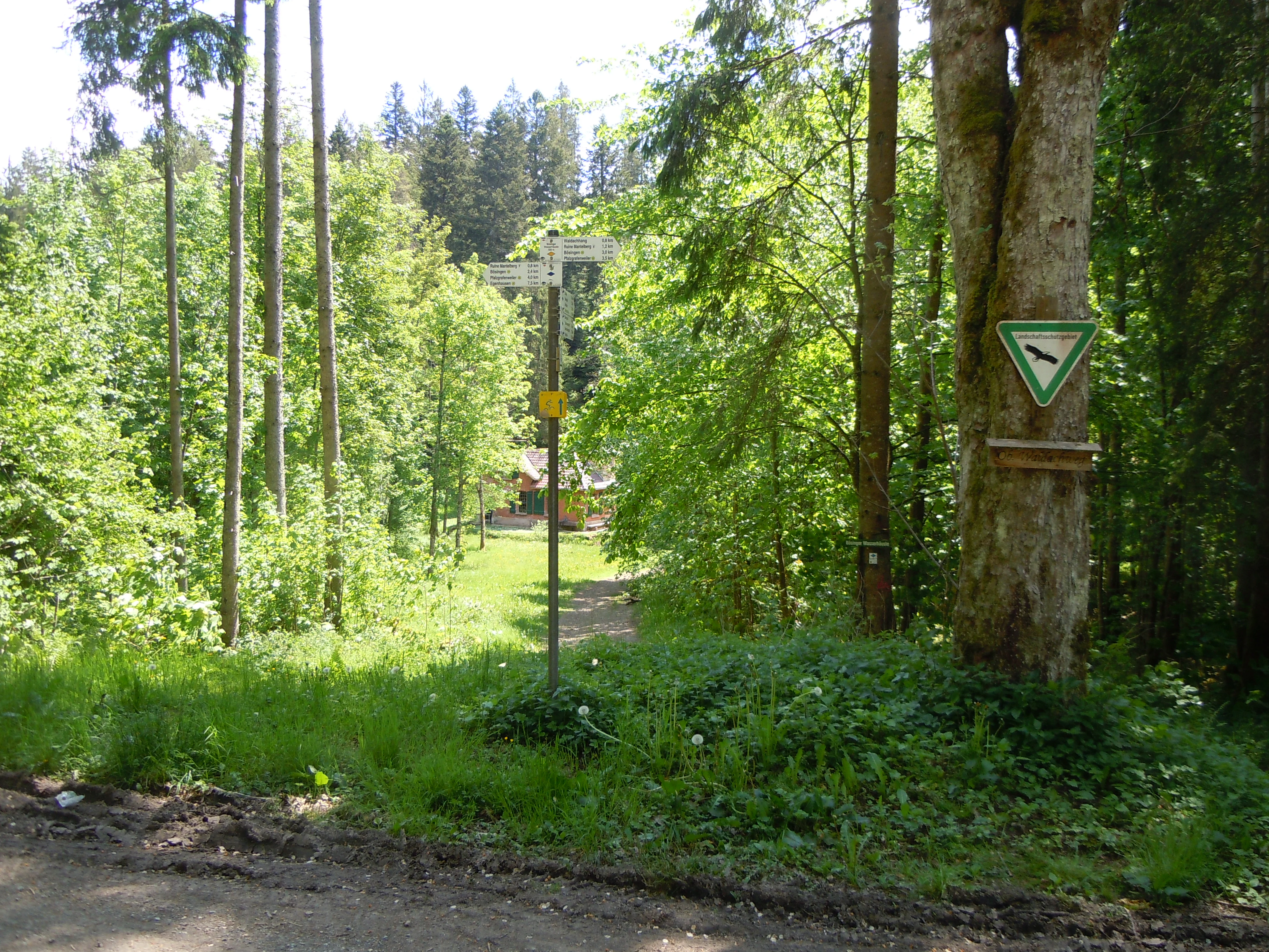
A dirt hiking path enters a dense forest, with a metal signpost indicating directions and a triangular green protected area shield attached to a large tree on the right.
A hiking trail intersection marked by signage in the Waldachtal mit Seitentälern protected area.

Waldachtal mit Seitentälern history and protected-area timeline

Waldachtal mit Seitentälern was formally established as a Landschaftsschutzgebiet, or protected landscape, on 1 December 1998 through a decree issued by the Landratsamt Freudenstadt. The designation was the result of an effort to safeguard the most ecologically valuable sections of the Waldach valley and its tributary valleys, recognizing that the area's mix of meandering streams, floodplain meadows, riparian woodland edges, and small-scale wetlands was a regionally significant feature of the northern Black Forest.

The formal protection built on a long-standing tradition of careful land use in these valleys, where centuries of small-scale agriculture and forestry had shaped a landscape of open meadows, hedges, and forest margins. By placing these features under statutory protection, the local authorities sought to preserve not only the habitats themselves but also the traditional cultural landscape that supports them. Today, the area continues to be administered by the Landkreis Freudenstadt and sits within the wider framework of the Naturpark Schwarzwald Mitte/Nord.

Waldachtal mit Seitentälern landscape and geographic character

The landscape of Waldachtal mit Seitentälern is defined by a series of narrow, often steep-sided stream valleys that cut through the rolling terrain between the Obere Gäue and the Schwarzwald-Randplatten. The four protected sections follow the natural course of the Waldach and the Cresbach, with valley stretches that pass close to the settlements of Neu-Nuifra, Cresbach, Unterwaldach, Oberwaldach, and Vesperweiler. The terrain combines gentle valley floors with surrounding slopes that transition from open meadow to woodland.

Along the valley bottoms, freely meandering brook sections alternate with grassy floodplain meadows and banks lined by a continuous strip of riparian woodland. The slopes above the meadows are typically bordered by traditional hedges and structurally rich forest margins, which mark the edge between the open valley and the denser forest cover of the surrounding Black Forest plateau. Ponds, springs, and small ditches add further variation to the valley floors.

Above the valley edges, the surrounding landscape reflects the character of the Schwarzwald-Randplatten, with forested ridges and plateau-like surfaces that descend toward the more open character of the Obere Gäue. The overall impression is of a small-scale, finely structured valley landscape typical of the transition zone between the northern Black Forest and the adjacent Gäu uplands.

Waldachtal mit Seitentälern ecosystems, habitats, and plant life

Ecologically, Waldachtal mit Seitentälern is notable for the diversity of habitats compressed into a relatively small area. The protected valley sections combine flowing waters, standing waters, wet meadows, dry meadows, reed beds, hedges, and forest edges, producing a mosaic that supports a wide variety of plant and animal species.

The floodplain meadows along the meandering brooks are among the most important habitats within the area. Where traditional open management has been maintained, these meadows remain species-rich and serve as habitat for many meadow-dependent plants and invertebrates. The continuous strip of riparian woodland along the watercourses provides shade, bank stabilization, and habitat connectivity, while also functioning as a natural buffer between the meadows and the surrounding farmland and forest.

Further habitat diversity is provided by a network of small-scale wetlands, including ponds, springs, ditches, and reed beds. These elements add moisture and structural complexity to the valley floor and are particularly important for amphibians, dragonflies, and wetland plants. Together with hedges and natural forest margins, they help maintain the ecological coherence of the protected landscape.

Waldachtal mit Seitentälern wildlife and species highlights

Because of its diversity of habitats, Waldachtal mit Seitentälern supports a rich community of species typical of near-natural Black Forest valley landscapes. The combination of flowing waters, ponds, wet meadows, reed beds, hedges, and forest margins provides breeding, feeding, and sheltering conditions for many groups of animals.

The streams and wetlands of the Waldach and Cresbach valleys are particularly important for amphibians, aquatic invertebrates, and dragonflies, while the species-rich meadows offer habitat for meadow-breeding birds and a wide range of pollinating insects. The continuity of hedges and riparian woodland across the landscape creates valuable corridors for small mammals, bats, and many forest-edge bird species, supporting the broader biodiversity of the northern Black Forest.

The protected area's designation explicitly recognizes the importance of these habitats for a partially threatened flora and fauna, making the protection of the valley wildlife one of the central motivations behind the area's establishment in 1998.

Waldachtal mit Seitentälern conservation status and protection priorities

The conservation significance of Waldachtal mit Seitentälern lies in its role as a refugium for the traditional ecological character of the Waldach valley and its side valleys. The area was designated as a Landschaftsschutzgebiet in 1998 to preserve the near-natural quality of the valley landscape, its functioning natural balance, and the diversity of habitats that depend on careful management.

A central aim of the protection is to keep the valley floodplains open and maintain their ecologically valuable meadows, meandering brook sections, and riparian woodland edges. Equally important is the conservation of small-scale wetlands such as ponds, springs, watercourses, ditches, reed beds, and wet meadows, which together form a network of humid habitats critical to regional biodiversity.

The protection also seeks to preserve and restore traditional landscape elements such as hedges and forest margins, which connect the different habitat types and support landscape-level ecological processes. By maintaining these features, the area contributes to the broader conservation goals of the Naturpark Schwarzwald Mitte/Nord and helps secure a representative example of the valley landscapes of the northern Black Forest for the long term.

Top sights and standout views in Waldachtal mit Seitentälern

A compact network of four protected valley sections along the Waldach and Cresbach streams, set within the Naturpark Schwarzwald Mitte/Nord. Traditional species-rich floodplain meadows, freely meandering brook sections, and continuous riparian woodland edges define the valley experience. A diverse mosaic of wet meadows, ponds, springs, ditches, reed beds, hedges, and forest margins supports rich regional biodiversity across a small but structurally rich area.

Monthly climate preview

Long-term temperature and precipitation averages for Waldachtal mit Seitentälern

Waldachtal mit Seitentälern Climate Normals and Monthly Weather Records

Representative coordinates record annual temperature swings alongside consistent monthly precipitation patterns for Waldachtal mit Seitentälern. Detailed monthly climate normals provide a complete comparative baseline for this Baden-Württemberg protected terrain.
Annual mean8 °C
-1 °C18 °C
Jan-1°
Feb
Mar
Apr
May12°
Jun16°
Jul18°
Aug18°
Sep14°
Oct
Nov
Dec
Warmest month
July

18.1 °C

Coolest month
January

-0.9 °C

Wettest month
July

3.1 mm/day

Driest month
April

1.9 mm/day

Park location guide

Geography guide, regional context, and park location map for Waldachtal mit Seitentälern

Waldachtal mit Seitentälern park geography, regions, and map view in Germany

Understand where Waldachtal mit Seitentälern sits in Germany through a broader geographic reading of the surrounding landscape, nearby location context, and its mapped position within the national park landscape.

How Waldachtal mit Seitentälern fits into Germany

Germany is a federal republic in Western and Central Europe with a population of over 83 million across sixteen constituent states. It is Europe's largest economy by nominal GDP and a major global exporter and importer. The capital is Berlin, and the country borders Denmark, Poland, Czech Republic, Austria, Switzerland, France, Luxembourg, Belgium, and the Netherlands.

Wider geography shaping Waldachtal mit Seitentälern in Germany

Germany is located in Western and Central Europe, spanning 357,022 km². It borders Denmark to the north, Poland and the Czech Republic to the east, Austria and Switzerland to the south, and France, Luxembourg, Belgium, and the Netherlands to the west. The country has coastlines on the Baltic Sea and North Sea to the north, with the Alps located in the southern region.

Map view of Waldachtal mit Seitentälern

Use this park location map to pinpoint Waldachtal mit Seitentälern in Germany, understand its exact geographic position, and read its mapped placement within the surrounding landscape more clearly.

Pigeon | © OpenStreetMap contributors

Location context for Waldachtal mit Seitentälern

Baden-Württemberg

Visualizing the stream valleys, riparian woodland, and floodplain meadows of the northern Black Forest

Waldachtal mit Seitentälern Photos and Protected Landscape Scenery

Visual records capture the intimate stream valleys, meandering brooks, and species rich floodplain meadows that define the protected landscape of Waldachtal mit Seitentälern. Studying these habitats and forest margins reveals the diverse ecological character of the northern Black Forest transition zone.

A dirt hiking path enters a dense forest, with a metal signpost indicating directions and a triangular green protected area shield attached to a large tree on the right.

Park atlas

Compare regional valley reserves and protected areas across Baden-Württemberg.

Parks Near Waldachtal mit Seitentälern and Surrounding Protected Landscapes

Browse other protected areas and stream valley reserves located near Waldachtal mit Seitentälern in southwestern Germany. Comparing these adjacent natural regions provides deeper insight into the broader highland geography and valley ecosystems of the northern Black Forest.
A horizontal watercolor painting showing a winding river through a soft green valley with rolling hills in the background.
Protected landscapeBaden-Württemberg
About 8.8 km away#1 closest

North

Nagoldtal Protected Landscape: Geography and River Valley Map of the Calw District

A northern Black Forest river corridor spanning eight municipalities

Analyze the territorial structure of Nagoldtal, a designated protected landscape spanning over four thousand hectares in the Calw district. The valley scenery reflects the intersection of the Schwarzwald-Randplatten and the Obere Gäue, characterized by a mosaic of forested slopes, open river valleys, and historical settlement patterns that define this prominent conservation corridor in southwestern Germany.

Area
43.584 km²
Established
1971
IUCN
V
Relief
Upland
Protected landscapeBaden-Württemberg
About 9.9 km away#2 closest

Southeast

Südhänge des Neckartales, Berghänge des Haugenloches, Alte Bildechinger Steige, Altheimer Tal und angrenzende Hochflächen

Protected Landscape in the Upper Neckar Valley, Baden-Württemberg

This protected area preserves a mosaic of forested slopes, juniper heaths, and agricultural plateaus along the Neckar. It offers a clear view into the cultural history and regional geography of the Obere Gäue in southwestern Germany.

Area
2.62 km²
Established
1965
IUCN
V
Watercolor painting of a pastoral river valley landscape with soft green hills and wooded ridgelines on a white background.
Protected landscapeBaden-Württemberg
About 13 km away#3 closest

South

Oberes Neckartal Protected Landscape: Geography and Mapped Boundaries

A regional conservation area within the Obere Gäue natural region.

Spanning a distinct stretch of the upper Neckar river, Oberes Neckartal acts as a structural conservation corridor in Baden-Württemberg. The area is defined by its deep valley incision, flat agricultural meadows, and steep forest-covered slopes, which create a consistent landscape motif throughout the Freudenstadt district.

Area
6.275 km²
Established
2001
IUCN
V
Relief
Upland
Protected landscapeBaden-Württemberg
About 17 km away#4 closest

North

Teinachtal mit Seitentälern: Protected River Valley Landscape in the Northern Black Forest

Geographic map overview of the Teinach river valley and tributary systems.

The Teinachtal mit Seitentälern protected area serves as a significant conservation zone in the Landkreis Calw. This landscape, integrated with the Naturpark Schwarzwald Mitte and Nord, preserves a richly structured network of stream corridors and forest slopes that connect diverse local habitats.

Area
12.606 km²
Established
2000
IUCN
V
Protected landscapeBaden-Württemberg
About 17 km away#5 closest

Southeast

Heselgraben Protected Landscape: Baden-Württemberg Regional Geography and Terrain Mapping

A classic mosaic of meadows and fields in the Obere Gäue region

Heselgraben represents a significant protected area within the Baden-Württemberg state, characterized by its intricate juxtaposition of small-scale agricultural habitats. Located between Muschelkalk and Keuper geological zones, the landscape provides a dense, mapped look at traditional European hedgerow and grassland management along the Empfinger Bach stream.

Area
0.378 km²
Established
1989
IUCN
V
Relief
Upland
Protected landscapeBaden-Württemberg
About 18 km away#6 closest

South

Hachtel und Türnental Protected Landscape: Map, Geography, and Regional Setting in Germany

A traditional Muschelkalk valley and riparian landscape in Baden-Württemberg.

Discover the geographic composition of Hachtel und Türnental, a protected landscape in Dornhan, Baden-Württemberg. This area preserves a fine-grained mosaic of meadows, gallery woodland along the Türnenbach stream, and old fruit orchards that define the traditional rural character of the Obere Gäue plateaus.

Area
0.597 km²
Established
1962
IUCN
V
Watercolor depiction of a river flowing through a forested landscape with rolling mountains in the background
National parkBaden-Württemberg
About 18 km away#7 closest

West

Black Forest National Park: Baden-Württemberg National Park Geography and Mapped Protected Areas

Explore the mapped boundaries and landscape context of this protected area.

Black Forest National Park serves as a focal point for understanding protected landscapes in Baden-Württemberg. This detailed view highlights its specific geographic identity, mapped boundaries, and its position within the regional atlas. Examine the natural terrain and conservation context that define this important national park.

Area
100.62 km²
Established
2014
IUCN
II
Relief
Mountain
A watercolor painting showing a wide view of a winding river flowing through a lush green valley with distant purple hills and forested ridges.
Protected landscapeLandkreis Tübingen
About 20 km away#8 closest

Southeast

Oberes Neckartal mit den Seitentälern Rommelstal, Starzeltal und Eyachtal Protected Landscape

Geographic landscape analysis of the upper Neckar river valley and its forested tributaries.

Situated within Landkreis Tübingen, this protected landscape is defined by its distinct Muschelkalk geology and the interplay between deep valley slopes and open orchard meadows. The area encompasses the upper Neckar river valley along with the side valleys of Rommelstal, Starzeltal, and Eyachtal. This detailed landscape profile provides insight into the structured natural environment, forest coverage, and fluvial terrain that characterize this region of southwestern Germany.

Area
23.364 km²
Established
1981
IUCN
V
Relief
Upland

Common questions about visiting, size, designation, and location context for Waldachtal mit Seitentälern

Waldachtal mit Seitentälern FAQs for park facts, access, geography, and protected area context

Find quick answers about Waldachtal mit Seitentälern, including protected-area facts, park geography, trail and visitor context, and how the park fits into its surrounding country and regional landscape.
MoriAtlas Explorer

Continue Your Protected Areas Search Across the Global Atlas

Deepen your exploration by continuing the structured search for national parks and protected areas worldwide. Utilize the comprehensive filtering capabilities to compare different conservation landscapes and refine your understanding of global park geography. Discover more about the distribution and characteristics of protected natural areas.

Global natural geography