Mori Atlas logo
Protected landscapeWaldteil bei der Lochmühle

A small but ecologically significant forest corridor within the northern Black Forest region.

Waldteil bei der Lochmühle Protected Landscape and Riparian Forest Geography in Baden-Württemberg

(Landschaftsschutzgebiet "Waldteil bei der Lochmühle")

Waldteil bei der Lochmühle serves as a vital protected landscape in the Landkreis Karlsruhe, preserving a rare strip of alder and ash floodplain forest along the Lochmühlegraben stream. This protected area functions as a key node within the regional Natura 2000 network and the broader Naturpark Schwarzwald Mitte/Nord. As an example of stream-side riparian conservation, the site remains an essential woodland fragment within the cultivated rolling hills of the northern forefield landscape.

protected landscapelandscape protection areasmall forest patchriparian woodlandalder-ash forestfloodplain forest

Waldteil bei der Lochmühle

Protected landscape

Park overview

Structured park overview, official facts, and landscape profile for Waldteil bei der Lochmühle

Waldteil bei der Lochmühle park facts, protected area profile, and essential visitor context

Review the core facts for Waldteil bei der Lochmühle, including designation, size, terrain, visitor scale, habitats, and operating context in one park-focused overview.

About Waldteil bei der Lochmühle

Waldteil bei der Lochmühle is a compact protected landscape, technically classified under IUCN Category V as a Protected Landscape/Seascape, located in the north of Baden-Württemberg near the city of Ettlingen. It is one of many small Landschaftsschutzgebiete in the Landkreis Karlsruhe, but it stands out because of the strength of its natural features relative to its tiny size. The entire protected parcel is just over one hectare, yet it preserves a complete, intact stretch of moist stream-side woodland that would otherwise be unusual in this intensively used foothill region.

The landscape setting belongs to the Ortenau-Bühler Vorberge, the gentle forefield ridges that lie between the Rhine plain and the higher Black Forest. In this transitional zone, forests generally occur only in small patches between farmland, orchards, and meadows. Waldteil bei der Lochmühle lies within such a patchwork, in the narrow valley of the Lochmühlegraben between Sulzbach and Oberweier. The forest has survived here because the small stream course and its immediate banks never converted to agricultural use.

The ecological importance of the site extends beyond its size. It sits within the FFH (Flora-Fauna-Habitat) site "Wälder und Wiesen bei Malsch," a larger European-protected area that conserves representative forest and meadow habitats of the region. It also falls inside the Naturpark Schwarzwald Mitte/Nord, a wide, sustainability-oriented park zone covering the central and northern Black Forest. Adjacent features include the Lochmühlenweiher natural monument slightly upstream and the Vorbergzone protected landscape further along the same general valley system.

Because of this combination of small size, intact native woodland, and integration into a wider network of protected sites, Waldteil bei der Lochmühle functions less as a dramatic scenic attraction and more as a careful conservation instrument, safeguarding a representative fragment of a habitat type that is considered a priority for protection at the European level.

Quick facts and research context for Waldteil bei der Lochmühle

Waldteil bei der Lochmühle is a Landschaftsschutzgebiet, or protected landscape, in Baden-Württemberg, Germany. It was designated on 15 October 1962 by the Landratsamt Karlsruhe through a collective ordinance and is administered by that same office. The area lies on the territory of the city of Ettlingen in the Landkreis Karlsruhe, between Sulzbach and Oberweier in the valley of the Lochmühlegraben.

The protected parcel is a single cadastral plot of about 1.32 hectares in the local field-name "Edelsheck" and is entirely forested. It sits within the natural region known as the Ortenau-Bühler Vorberge and overlaps with the larger FFH site "Wälder und Wiesen bei Malsch," as well as the Naturpark Schwarzwald Mitte/Nord. The site also lies very close to the natural monument Lochmühlenweiher and another protected landscape known as the Vorbergzone between Ettlingenweier and Malsch.

Protection and recognition

Examine the official conservation records and protected area designation metrics.

Waldteil bei der Lochmühle Protection Status and Designated Area Record

Waldteil bei der Lochmühle gathers documented protection metrics and official registry data within the global protected area network. Conservation researchers access verified management status and international database records for comprehensive geographic analysis.

Protection details

WDPA ID
325625
Park context

Deeper park guide and search-rich context for Waldteil bei der Lochmühle

Waldteil bei der Lochmühle history, landscape, wildlife, and travel context

Explore Waldteil bei der Lochmühle through its history, landscape character, ecosystems, wildlife, conservation priorities, cultural context, and seasonal travel timing in a structured park guide built for atlas discovery and search intent.

Why Waldteil bei der Lochmühle stands out

Waldteil bei der Lochmühle is known primarily for its exceptionally small but ecologically significant patch of black-alder and ash floodplain forest along the Lochmühlegraben. This woodland has been identified as a priority habitat type under the European Union Habitats Directive, classifying it as a representative example of alder, ash, and willow riparian woodland. The area is also recognized for an individual mature elm tree in its southwestern corner that has been designated as a natural monument. Together, these features make the protected landscape a notable, if minor, example of how small stream-side forest relicts can carry disproportionate ecological and conservation value within the broader cultivated forefield landscape of the northern Black Forest margin.
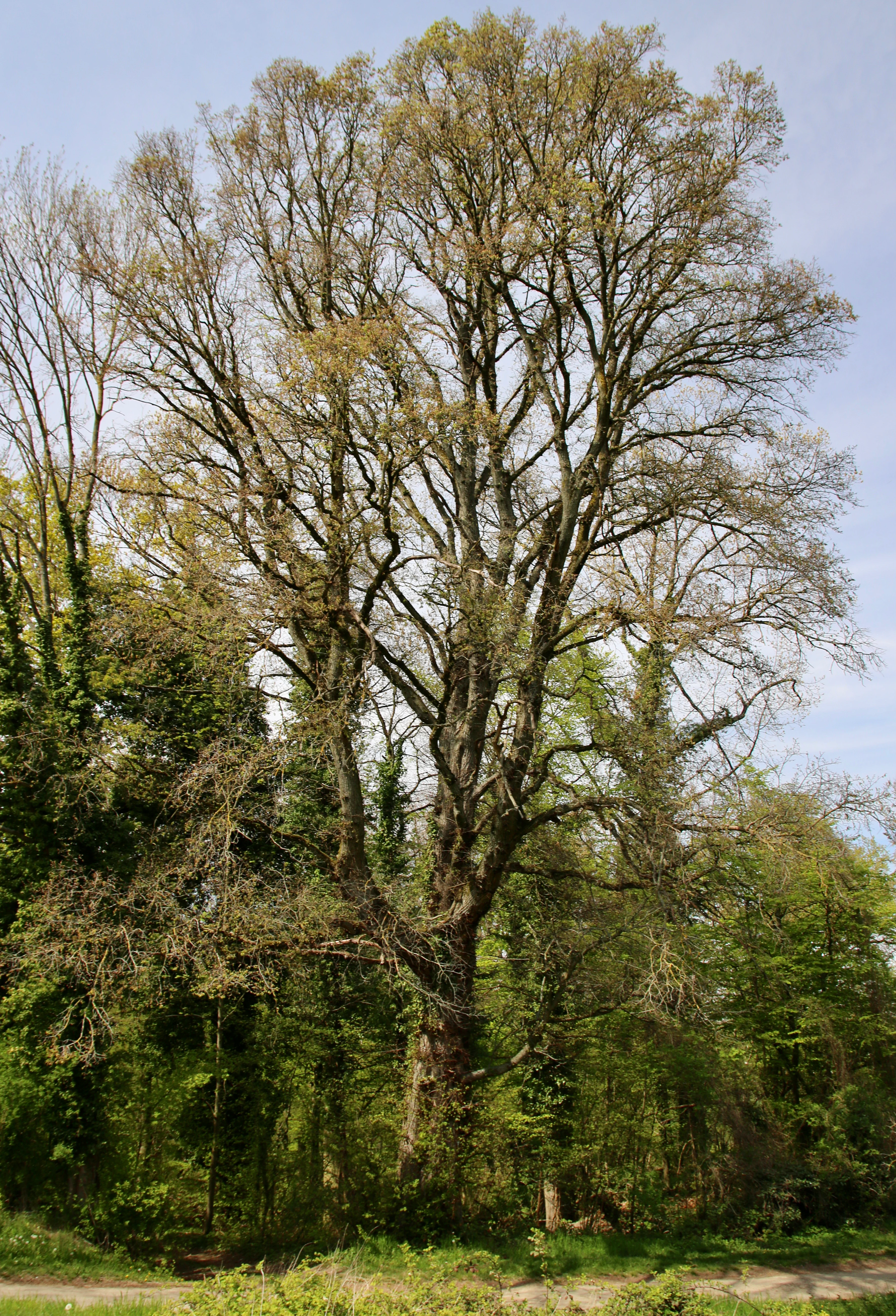
A tall, large deciduous tree with sparse early spring foliage and spreading branches standing among denser green forest vegetation under a partly cloudy sky
Large elm tree west of the Lochmühle in the Waldteil bei der Lochmühle protected landscape

Waldteil bei der Lochmühle history and protected-area timeline

Waldteil bei der Lochmühle was formally designated as a Landschaftsschutzgebiet on 15 October 1962 by the Landratsamt Karlsruhe. The designation was issued as part of a Sammelverordnung, a collective ordinance that established several protected landscapes in the district at the same time, reflecting a period when German authorities systematically catalogued remaining natural and semi-natural landscapes for long-term protection.

The decision was consistent with broader post-war environmental policy in West Germany, which increasingly used the Landschaftsschutzgebiet status to shield small but characteristic fragments of forest, meadow, and watercourse habitat from further agricultural conversion, development pressure, or forestry intensification. In this case, the focus was a single cadastral plot ("Flurstück") in the Edelsheck area, preserving a remaining strip of moist woodland along a small stream.

Since its designation, the protected area has remained a stable, low-profile component of the Landkreis Karlsruhe ecological network. Its ongoing role within the larger FFH site "Wälder und Wiesen bei Malsch" and within the Naturpark Schwarzwald Mitte/Nord confirms that the small 1962 designation has retained administrative and ecological relevance more than sixty years on. Recognition of part of the forest as a priority FFH habitat type and of a specific elm tree as a natural monument later added further layers of protection to the same small parcel.

Waldteil bei der Lochmühle landscape and geographic character

The protected area sits in the Ortenau-Bühler Vorberge, the broad zone of low hills and shallow valleys that forms a transition between the Upper Rhine plain and the central Black Forest. This is a gently rolling landscape where cultivated fields, meadows, orchards, and small woodland fragments alternate. The valley of the Lochmühlegraben, in which the protected forest lies, is one of many shallow stream valleys that interrupt the otherwise open forefield surface.

The forest itself is a narrow, elongated tract that closely follows the contour of the small stream, the Lochmühlegraben. Because the stream corridor is steep and the soils are moist, this strip was never ploughed, allowing forest cover to persist as a thin green ribbon between adjacent open country. Today the entire 1.32 hectares is wooded, giving the area the character of a continuous forest island within an agricultural matrix rather than a large continuous woodland.

The southwestern part of the parcel is marked by a particularly old elm tree, listed as a natural monument, which contributes to the local character and stands as a striking individual feature in an otherwise uniformly forested slope. Immediately upstream from the protected area lies the Lochmühlenweiher, a small pond designated as a flächenhaftes Naturdenkmal, or area natural monument, and slightly further away lies the larger Vorbergzone protected landscape, helping to anchor Waldteil bei der Lochmühle within a system of stream-influenced green corridors.

Waldteil bei der Lochmühle ecosystems, habitats, and plant life

Waldteil bei der Lochmühle functions ecologically as a small, intact fragment of floodplain-influenced forest within an otherwise heavily used forefield landscape. The vegetation directly along the Lochmühlegraben has the character of a black-alder and ash forest community, with alder (Alnus glutinosa), ash (Fraxinus excelsior), and willow species as the dominant woody elements. This community is consistent with the European habitat type 91E0, "Auenwälder mit Erle, Esche, Weide," or riparian woodlands of alder, ash, and willow along active or former floodplains.

Because habitat 91E0 is listed as a priority habitat under the European Union Habitats Directive, the site's classification carries real conservation weight: a protected landscape in Germany is being used, in part, to maintain a representative European priority habitat within a tiny parcel. The presence of standing water and the long-unbroken forest cover support moisture-loving ground flora typical of such woodland, including ferns, tall herbs, and other species that rarely persist in surrounding open fields.

The forest also functions as a habitat island and ecological stepping stone. It sits within the larger FFH site "Wälder und Wiesen bei Malsch," which conserves a broader mosaic of forests and meadows around the Malsch area. By maintaining continuous canopy cover and naturally fallen deadwood along the stream, the protected parcel supports the kinds of microhabitats, including shaded, humid forest floor conditions, rotten wood, and stream banks, that allow specialist plants, insects, and fungi associated with old riparian forest to persist in the region.

Waldteil bei der Lochmühle wildlife and species highlights

Because the source documentation focuses primarily on vegetation and habitat classification rather than explicit faunal inventories, detailed wildlife information for Waldteil bei der Lochmühle cannot be stated with certainty. Nevertheless, the site's character as a continuous, moist, structurally diverse riparian woodland in an otherwise open agricultural landscape implies a meaningful wildlife role.

Such stream-side alder-ash forests in the northern Black Forest forefield are typically used by cavity-nesting birds, woodland songbirds, and various bat species that rely on old trees with fissures and hollows; the presence of the protected elm in the southwest of the parcel is therefore ecologically relevant beyond its botanical status. Amphibians and aquatic invertebrates are commonly associated with small headwater streams like the Lochmühlegraben, particularly where shade and leaf-litter input maintain cool, oxygenated water.

The wider ecological context, including its position within the FFH site "Wälder und Wiesen bei Malsch" and the Naturpark Schwarzwald Mitte/Nord, means that any species movement across the area contributes to regional connectivity for forest-dwelling and stream-dependent fauna. However, given the limited wildlife-specific information available, the park should not be characterized in this record by specific named species that are not clearly documented in the source material.

Waldteil bei der Lochmühle conservation status and protection priorities

Waldteil bei der Lochmühle is a useful illustration of how Germany's Landschaftsschutzgebiet instrument operates at the smallest meaningful scale. The site's principal conservation value is the preservation of a complete, unfragmented riparian woodland patch along the Lochmühlegraben, including the part classified as the European priority habitat type 91E0, alder-ash-willow floodplain forest. By safeguarding this 1.32-hectare plot, the protections maintain habitat continuity that would otherwise be largely absent in the surrounding Vorberg farmland.

The designation was made by the Landratsamt Karlsruhe under the broader regional framework for protected landscapes in Baden-Württemberg and is administrated by the same office. Its overlap with the FFH site "Wälder und Wiesen bei Malsch" integrates the local protection into the European Natura 2000 network, reinforcing its conservation standing and binding it to habitat monitoring and reporting obligations at the EU level.

Recognition of an individual elm in the southwestern part of the area as a Naturdenkmal adds a second, complementary layer of protection. Together, the Landscape Protection Area status, Natura 2000 inclusion, and Naturdenkmal designation form a nested protection regime that preserves the area's ecological value despite its small footprint.

Waldteil bei der Lochmühle cultural meaning and human context

Waldteil bei der Lochmühle does not give rise to a distinct cultural narrative in the available source material, and the area is not described in terms of historical human use, traditional land tenure, or local folklore. Its cultural framing is implicit rather than prominent: the local field-name "Edelsheck" and nearby place names such as Lochmühle ("hole mill") and Oberweier reflect the traditional rural character of this part of the Ettlingen countryside, where small mills, scattered hamlets, and field-named parcels shaped the historic landscape.

The presence of a mature elm as a recognized natural monument reflects a broader Central European cultural tradition of valuing individual old trees as community landmarks and sources of identity within agricultural countryside. In that sense, the protected area participates, however modestly, in the long-standing regional practice of marking and conserving individually significant trees. There is, however, no indication of deeper indigenous, ritual, or settlement-related cultural associations specific to this protected landscape that would justify an extended cultural narrative.

Top sights and standout views in Waldteil bei der Lochmühle

The defining highlights of Waldteil bei der Lochmühle are tightly focused on its ecological character rather than on dramatic scenery. The most important highlight is the protected patch of black-alder and ash riparian woodland along the Lochmühlegraben, designated as a priority habitat type under the European Habitats Directive. A second highlight is the individually protected mature elm in the southwestern corner of the area, recognized as a Naturdenkmal.

Its position inside both the Natura 2000 site "Wälder und Wiesen bei Malsch" and the Naturpark Schwarzwald Mitte/Nord adds a further highlight: the small protected area functions not as an isolated site but as a node within a much larger protected landscape network. The combination of long-standing 1962 protection status, European-level habitat recognition, and integration into regional ecological planning places Waldteil bei der Lochmühle among the more thoroughly protected tiny forest parcels of the Landkreis Karlsruhe.

Best time to visit Waldteil bei der Lochmühle

Because Waldteil bei der Lochmühle is a small protected woodland landscape rather than a visitor attraction in the conventional sense, the timing of any visit is dictated mainly by general woodland experience rather than operational considerations. The site is best appreciated in late spring and early summer, when the herb layer of the alder-ash forest is fully developed and the foliage of the canopy provides the dense, shaded character that defines the habitat. Late summer visits can also be rewarding for observing the stream corridor at low water, while autumn offers strong color and the visual character of older mixed deciduous woodland.

For broader regional exploration, the surrounding Vorberg landscape between Sulzbach and Oberweier, as well as the nearby Naturpark Schwarzwald Mitte/Nord, is generally most attractive from late spring through early autumn, when forest tracks and adjacent meadows are at their most accessible and visually expressive. Winter visits are of course possible in calm weather but offer less ecological or sensory payoff in such a small wooded parcel.

Monthly climate preview

Long-term representative climate patterns and monthly averages across the park coordinate

Annual Temperature and Precipitation Normals for Waldteil bei der Lochmühle

Historical data records a measured annual temperature range from sub-zero winter minimums to warm summer maximums alongside consistent monthly precipitation rates at the reference point. Examining the complete twelve-month climatology profile reveals detailed variations in temperature and moisture across the representative coordinate.
Annual mean10 °C
1 °C21 °C
Jan
Feb
Mar
Apr10°
May15°
Jun19°
Jul21°
Aug20°
Sep16°
Oct10°
Nov
Dec
Warmest month
July

20.9 °C

Coolest month
January

0.6 °C

Wettest month
May

2.3 mm/day

Driest month
April

1.5 mm/day

Park location guide

Geography guide, regional context, and park location map for Waldteil bei der Lochmühle

Waldteil bei der Lochmühle park geography, regions, and map view in Germany

Understand where Waldteil bei der Lochmühle sits in Germany through a broader geographic reading of the surrounding landscape, nearby location context, and its mapped position within the national park landscape.

How Waldteil bei der Lochmühle fits into Germany

Germany is a federal republic in Western and Central Europe with a population of over 83 million across sixteen constituent states. It is Europe's largest economy by nominal GDP and a major global exporter and importer. The capital is Berlin, and the country borders Denmark, Poland, Czech Republic, Austria, Switzerland, France, Luxembourg, Belgium, and the Netherlands.

Wider geography shaping Waldteil bei der Lochmühle in Germany

Germany is located in Western and Central Europe, spanning 357,022 km². It borders Denmark to the north, Poland and the Czech Republic to the east, Austria and Switzerland to the south, and France, Luxembourg, Belgium, and the Netherlands to the west. The country has coastlines on the Baltic Sea and North Sea to the north, with the Alps located in the southern region.

Map view of Waldteil bei der Lochmühle

Use this park location map to pinpoint Waldteil bei der Lochmühle in Germany, understand its exact geographic position, and read its mapped placement within the surrounding landscape more clearly.

Pigeon | © OpenStreetMap contributors

Location context for Waldteil bei der Lochmühle

Baden-Württemberg

Visual exploration of riparian woodland habitats and protected stream corridors

Waldteil bei der Lochmühle Photos and Landscape Scenery

Visual documentation of Waldteil bei der Lochmühle reveals the intimate structure of its protected black-alder and ash floodplain forest along the stream corridor. Examining these detailed landscape photographs helps researchers understand the ecological character and terrain features defining this small protected area within the agricultural foothills.

A tall, large deciduous tree with sparse early spring foliage and spreading branches standing among denser green forest vegetation under a partly cloudy sky

Park atlas

Compare nearby regional nature reserves and stream valley conservation areas

Other Parks Near Waldteil bei der Lochmühle and Surrounding Protected Landscapes

Visitors reviewing Waldteil bei der Lochmühle can browse adjacent protected landscapes, stream corridors, and forest patches across the northern Black Forest foothills. Expanding the geographic scope reveals how small riparian habitats connect into a broader regional network of conserved natural areas.
Protected landscapeBaden-Württemberg
About 11 km away#1 closest

South

Staatswald südlich Bernbach: Protected Landscape and Forested Ridge Atlas

Regional geography of the northern Black Forest in Baden-Württemberg

Staatswald südlich Bernbach represents a key protected landscape area in the northern Black Forest. Known for its continuous woodland covering peaks like the Tannschachberg and the Pfahlwald, the area also preserves unique wetland biotopes and designated natural monuments. This atlas entry provides a detailed look at the geographic boundaries and ecological context of this protected ridge system within the Calw district.

Area
6.471 km²
Established
1953
IUCN
V
Relief
Mountain
A watercolor painting showing a soft, atmospheric landscape with a foreground of water and green grasses, a midground of trees, and purple mountains in the background under a pale yellow sky.
Nature reserveRhineland-Palatinate
About 12 km away#2 closest

Northwest

Rheinniederung Neuburg-Wörth: A Protected Floodplain Landscape in Rhineland-Palatinate

An analysis of river meanders, oxbows, and floodplain forest geography

This nature reserve encompasses a 14.5 square kilometer corridor of the Upper Rhine, featuring a distinct topography of hardwood forests, wet meadows, and aquatic habitats. The site remains a focal point for understanding Rhine river dynamics and the conservation of rare floodplain ecosystems like the Wörther Altrhein.

Area
14.48 km²
Established
2004
Relief
Lowland
Climate
Temperate
Nature reserveBaden-Württemberg
About 15 km away#3 closest

Southeast

Eyach oberhalb Neuenbürg Nature Reserve: Mapped Geography and Protected Area Context

A diverse habitat mosaic in the northern Black Forest highlands

The Eyach oberhalb Neuenbürg nature reserve protects an intricate valley system that cuts through the northern Black Forest. This site is defined by its rich variety of forest, grassland, and rocky habitats clustered across steep hillsides and plateau surfaces. The data highlights the essential land cover and topographical features that sustain this protected area within the Baden-Württemberg regional landscape, offering a precise look at its ecological configuration and physical boundaries.

Area
3.219 km²
Established
2019
Relief
Mountain
Climate
Temperate
A watercolor illustration of a soft, rolling landscape featuring distant hills, forested midground, and a central winding meadow or stream area with wildflowers in the foreground.
Protected landscapeBaden-Württemberg
About 16 km away#4 closest

Northeast

Pfinzgau Protected Landscape: Mapping the Cultural Terrain of the Kraichgau Region

A structured geographic overview of the Pfinz valley landscapes.

Pfinzgau preserves a mosaic of woodlands, meadows, and orchards in the Karlsruhe district of Baden-Württemberg. This protected landscape functions as a green corridor within the Kraichgau, featuring near-natural forests, ancient field hedges, and stream corridors that define the regional relief. Study the mapped boundaries and natural terrain of this significant conservation area as it navigates the transition between the Black Forest and the Odenwald.

Area
21.496 km²
Established
1991
IUCN
V
Relief
Upland
Protected landscapeBaden-Württemberg
About 16 km away#5 closest

East

Grafenhausener Kirschengau: Protected Landscape and Regional Geography in Baden-Wurttemberg

Orchard meadows and Arnbach stream valley terrain.

Spanning 137 hectares near Birkenfeld, the Grafenhausener Kirschengau preserves a vital cultural and ecological mosaic in the Kraichgau uplands. This protected landscape combines calcareous grasslands, wooded slopes, and riparian gallery forest, offering a detailed glimpse into the region's traditional land-use history and geological heritage.

Area
1.366 km²
Established
1983
IUCN
V
Relief
Upland
A watercolor landscape illustration showing a gently winding water feature through low-lying marshy vegetation with distant rolling hills.
Protected landscapeBaden-Württemberg
About 17 km away#6 closest

Northeast

Füllbruch-Vokkenau Protected Landscape: Geographic Profile and Regional Map Context

Wetland mosaic and flood-retention geography in Baden-Württemberg

This protected landscape in Karlsruhe encompasses a distinct lowland floodplain forest, merging traditional orchard meadows with structured wet woodland terrain. The area is defined by its role in regional flood management for the Pfinz river, creating a unique intersection of protected natural habitat and active hydraulic infrastructure within the historical Kinzig-Murg lowland channel.

Area
4.313 km²
Established
1988
IUCN
V
Watercolor painting showing layers of rolling green hills, dense tree lines, and distant purple mountain silhouettes under a soft sunset sky.
Nature reserveGermany
About 18 km away#7 closest

Northwest

Riedried Nature Reserve: A Detailed Geographic Atlas of Bienwald Protected Wetlands

Wetland ecosystems and forest geography in Germany

Riedried is a specialized nature reserve in the Germersheim district of Germany, recognized for its black alder swamp forest and embedded lowland peat bog. This site serves as a crucial protected landscape within the Rhine plain, illustrating how small, managed wetlands function as a mosaic of rare habitat types in an otherwise drier forest region.

Area
0.25 km²
Established
1984
Relief
Lowland
Scope
Terrestrial
Watercolor painting of a tranquil wetland landscape with soft green vegetation and a calm water body, reflecting the floodplain environment of the Rhine river.
Nature reserveLandkreis Germersheim
About 18 km away#8 closest

North

Hördter Rheinaue Nature Reserve: Landscape and Geographic Context in Landkreis Germersheim

Examining the hydrology and floodplain forest of the German Rhine.

Hördter Rheinaue serves as a critical node in the Palatinate Rhine floodplains, preserving a vast mosaic of willow and poplar forests alongside stable hardwood stands. Analyze the mapped terrain shaped by centuries of river activity, including the meandering Michelsbach and associated oxbow systems that define this essential protected corridor in western Germany.

Area
8.18 km²
Established
1966
IUCN
IV
Relief
Lowland

Common questions about visiting, size, designation, and location context for Waldteil bei der Lochmühle

Waldteil bei der Lochmühle FAQs for park facts, access, geography, and protected area context

Find quick answers about Waldteil bei der Lochmühle, including protected-area facts, park geography, trail and visitor context, and how the park fits into its surrounding country and regional landscape.
MoriAtlas Explorer

Continue Your Protected Areas Search Across the Global Atlas

Deepen your exploration by continuing the structured search for national parks and protected areas worldwide. Utilize the comprehensive filtering capabilities to compare different conservation landscapes and refine your understanding of global park geography. Discover more about the distribution and characteristics of protected natural areas.

Global natural geography