
Mori Atlas logo
Protected landscapeWartbiegel - Katharinenlinde und Umgebung

Examining the orchard mosaic, regional relief, and conservation boundaries of this Swabian countryside.

Wartbiegel - Katharinenlinde und Umgebung: A Mapped Protected Landscape in Baden-Württemberg

(Landschaftsschutzgebiet Wartbiegel - Katharinenlinde und Umgebung)

Wartbiegel - Katharinenlinde und Umgebung is a designated protected landscape situated within the Neckar basin of southwestern Germany. This area preserves a compact, richly structured mosaic of traditional orchards, meadows, and woodland patches that contrast with the surrounding agricultural terrain. The mapped boundaries provide a detailed look at how this piece of Swabian countryside maintains habitat diversity and relief features on the outskirts of the Stuttgart metropolitan region.

protected landscapeLandschaftsschutzgebietNeckar basinorchard landscapeStreuobstwiesenfruit trees
A vibrant graphic illustration of a deep canyon with steep cliffs, a flowing river, a waterfall, and evergreen trees in the foreground under a stylized sky.

Wartbiegel - Katharinenlinde und Umgebung

Protected landscape

Park overview

Structured park overview, official facts, and landscape profile for Wartbiegel, Katharinenlinde und Umgebung

Wartbiegel, Katharinenlinde und Umgebung park facts, protected area profile, and essential visitor context

Review the core facts for Wartbiegel, Katharinenlinde und Umgebung, including designation, size, terrain, visitor scale, habitats, and operating context in one park-focused overview.

About Wartbiegel, Katharinenlinde und Umgebung

Wartbiegel - Katharinenlinde und Umgebung is a relatively small protected landscape in the Ludwigsburg district, situated on the western side of Schwieberdingen, a municipality in the greater Stuttgart metropolitan area. Although modest in size at around 42 hectares, the area plays a meaningful local role by safeguarding a stretch of traditional countryside in a region otherwise dominated by expanding settlement and infrastructure.

The protected landscape lies in the Neckar basin (Neckarbecken), one of the natural regions of Baden-Württemberg that is characterized by gentle relief, fertile soils, and a long history of mixed agricultural use. Within this broad setting, the Wartbiegel and the area around the Katharinenlinde form a particularly varied landscape section, and the protection ordinance specifically refers to this area as a landscape fragment that stands out from its wider surroundings because of its visual and structural diversity.

Designated in 1987, the protected area reflects a typical late-20th-century German approach to landscape conservation, in which not wilderness but rather the cultural landscape itself is the object of protection. The ordinance describes the core purpose as preserving the character, diversity, and ecological function of this landscape segment, while also safeguarding the traditional land-use structures that have shaped it, including continuing agricultural and orchard management. The local recreation value of the area is also explicitly recognized, situating the protected landscape as a nearby green space for residents of Schwieberdingen and surrounding communities.

Quick facts and research context for Wartbiegel, Katharinenlinde und Umgebung

Wartbiegel - Katharinenlinde und Umgebung is a designated protected landscape (Landschaftsschutzgebiet) in Baden-Württemberg, Germany, administered by the Untere Naturschutzbehörde of the Ludwigsburg district office.

It was established by ordinance on 16 November 1987, registered under the LSG number 1.18.012, and recognized in the international World Database on Protected Areas as WDPA ID 325658. The protected area covers approximately 42 hectares and lies west of Schwieberdingen in the natural region of the Neckar basin. Its protection aims center on preserving a visually distinctive and ecologically diverse rural landscape, with particular emphasis on traditional fruit-tree stands.

Protection and recognition

Examine documented terrestrial protection records and administrative designation data.

Wartbiegel - Katharinenlinde und Umgebung Protection Status and Protected Area Designation

Wartbiegel - Katharinenlinde und Umgebung maintains a documented terrestrial protection scope within official conservation registers. Detailed geographic facts outline the recorded designation framework and international database identifiers.

Protection details

Protection scope
Terrestrial
Transboundary protection
No
WDPA ID
325658
Park context

Deeper park guide and search-rich context for Wartbiegel, Katharinenlinde und Umgebung

Wartbiegel, Katharinenlinde und Umgebung history, landscape, wildlife, and travel context

Explore Wartbiegel, Katharinenlinde und Umgebung through its history, landscape character, ecosystems, wildlife, conservation priorities, cultural context, and seasonal travel timing in a structured park guide built for atlas discovery and search intent.

Why Wartbiegel, Katharinenlinde und Umgebung stands out

The protected area is best known for its traditional orchards (Streuobstwiesen), which are explicitly highlighted in the protection ordinance as especially worthy of preservation. These orchards sit within a varied, agriculturally used landscape whose relief and land-use mosaic stand out from the surrounding terrain. It is also notable as a compact example of a German protected landscape: a small, municipally relevant area where habitat diversity, traditional land use, and local recreation are combined within a single designation.
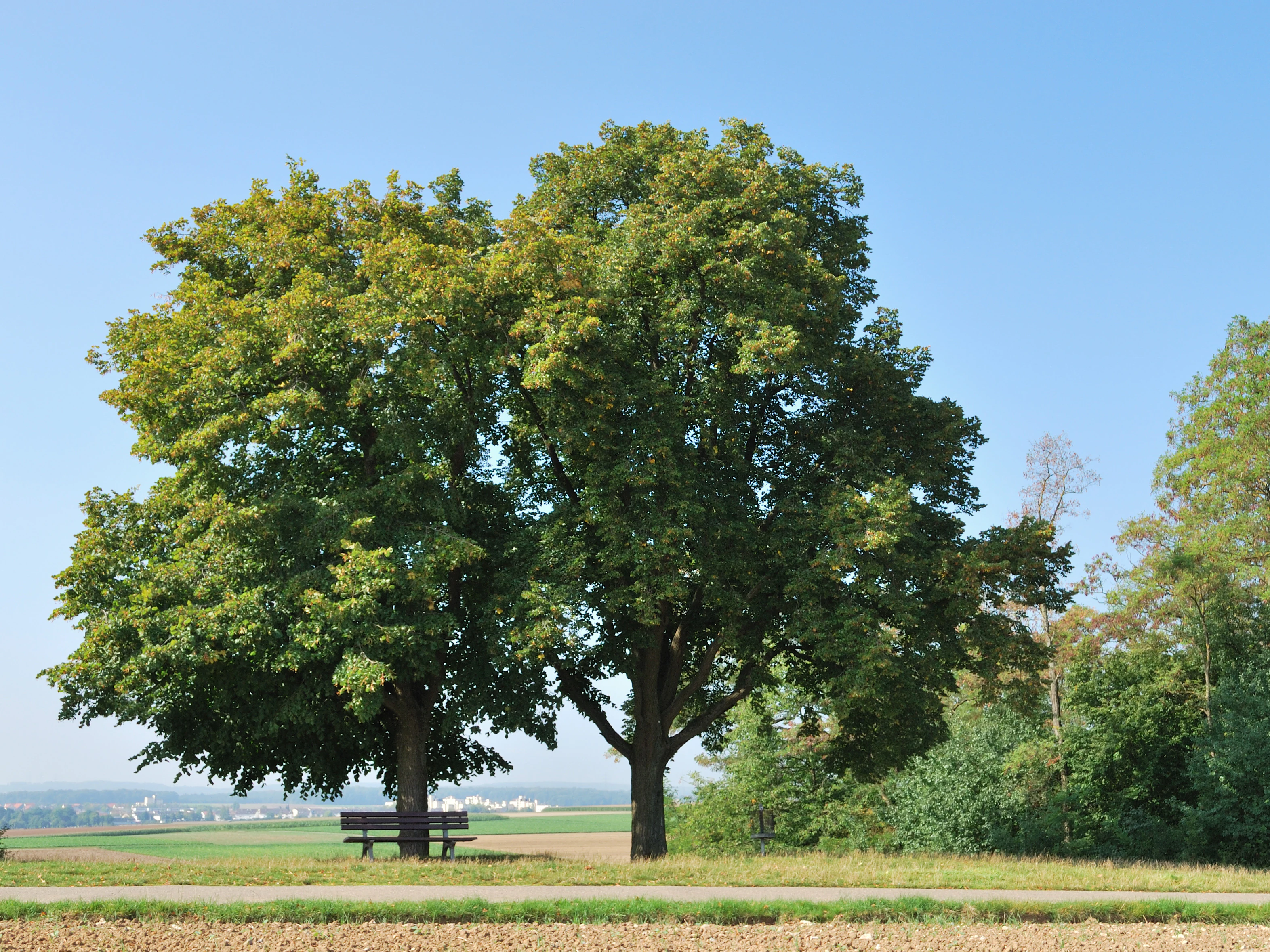
A large, mature linden tree stands prominently on a grassy hill, with a wooden bench placed beneath its branches and a distant view of fields under a clear blue sky.
The Katharinenlinde, a historic linden tree standing on a hill in the Wartbiegel protected landscape.

Wartbiegel, Katharinenlinde und Umgebung history and protected-area timeline

Wartbiegel - Katharinenlinde und Umgebung was formally designated as a protected landscape on 16 November 1987 by ordinance of the Untere Naturschutzbehörde (Lower Nature Conservation Authority) at the Landratsamt Ludwigsburg. It received the official LSG number 1.18.012 and was subsequently registered internationally in the World Database on Protected Areas under WDPA ID 325658.

The designation reflects the broader German tradition, particularly strong in Baden-Württemberg, of using the Landschaftsschutzgebiet category to protect culturally shaped rural landscapes in addition to strictly natural habitats. In this case, the focus is on preserving a locally distinctive segment of the Neckar basin landscape with its traditional orchards and varied relief.

The protected area continues to be administered by the district of Ludwigsburg and is documented in the state's Schutzgebietsverzeichnis (protected areas register) maintained by the Landesanstalt für Umwelt Baden-Württemberg.

Wartbiegel, Katharinenlinde und Umgebung landscape and geographic character

The protected landscape occupies a section of the Neckar basin (Neckarbecken), a natural region defined by gentle relief and agricultural land use. The terrain forms a varied mosaic of slopes, small ridges, and flatter areas, with the Wartbiegel itself giving the protected area part of its name and contributing to the locally distinctive relief.

Around this varied relief is a cultural landscape shaped by orchards, meadows, fields, and small woodland patches. The interplay of open cultivated land, scattered trees, and small forest remnants creates a richly textured rural scene that contrasts with the more uniform agricultural areas in the wider surroundings. Even though the protected area is small, its compact landscape pattern is one of its defining features.

Wartbiegel, Katharinenlinde und Umgebung ecosystems, habitats, and plant life

Ecologically, the protected landscape is shaped by the interaction between traditional agricultural land use and the underlying natural conditions of the Neckar basin. Orchards, meadows, field margins, hedgerows, and small woodland fragments combine to create a structurally diverse habitat mosaic.

This mosaic is the key ecological asset of the area. The protection ordinance emphasizes that the diversity of habitats found here supports a wide range of plants and animals, including species that depend on traditional orchard landscapes and on the transitional zones between woodland, meadow, and cultivated land. The fruit-tree stands in particular are singled out as ecologically valuable landscape elements, recognized not only for biodiversity support but also for their role in maintaining the cultural character of the area.

Wartbiegel, Katharinenlinde und Umgebung wildlife and species highlights

Because the protected area is a traditional cultural landscape rather than a wilderness, its wildlife interest lies mainly in the species associated with orchards, meadows, hedgerows, woodland edges, and small forest patches typical of the Neckar basin. The mixture of open land, scattered fruit trees, and woody cover provides nesting, foraging, and shelter opportunities for a range of insects, birds, and small mammals common to such habitats in southern Germany.

The ordinance explicitly recognizes the area's importance as habitat for animals and plants, highlighting the ecological significance of preserving the mosaic of land uses rather than prioritizing any single species.

Wartbiegel, Katharinenlinde und Umgebung conservation status and protection priorities

The primary conservation purpose of Wiesbühl - Katharinenlinde und Umgebung is to preserve the character, diversity, and ecological function of this locally distinctive landscape in the Neckar basin. The ordinance places particular weight on maintaining the variety of habitats that arise from the area's mixed land use, treating this diversity itself as a conservation value.

A specific focus is placed on the area's orchards. These traditional fruit-tree stands are described as particularly worthy of protection, both for their ecological role and for the visual and cultural identity they give the landscape. The ordinance also recognizes the area's importance for near-home recreation (Naherholung), positioning it as a protected piece of countryside that serves both biodiversity and the well-being of the local population.

By combining habitat protection, preservation of traditional land use, and recreational accessibility, the protected landscape exemplifies the multifunctional character of the German Landschaftsschutzgebiet category.

Wartbiegel, Katharinenlinde und Umgebung cultural meaning and human context

The protected landscape sits in a region with a long tradition of mixed agricultural use, orchard cultivation, and small-scale rural settlement typical of the eastern Neckar basin in Baden-Württemberg. The presence of older named landscape features such as the Katharinenlinde, a notable historic tree near Schwieberdingen, indicates that the area has been a familiar local landmark for generations.

By protecting the orchards and the surrounding landscape mosaic, the designation also implicitly safeguards a part of the region's rural heritage, including the traditional orchard meadows (Streuobstwiesen) that have shaped Swabian countryside for centuries.

Top sights and standout views in Wartbiegel, Katharinenlinde und Umgebung

Wartbiegel - Katharinenlinde und Umgebung stands out as a small but well-defined protected landscape along the western edge of Schwieberdingen, combining traditional orchards, varied relief, and accessible countryside on the fringes of the Stuttgart metropolitan area.

Best time to visit Wartbiegel, Katharinenlinde und Umgebung

As a small, agricultural protected landscape near Schwieberdingen, the area is primarily valued for walking and local recreation rather than as a seasonal travel destination. Spring blossom in the orchards, summer greenery in the meadows and hedgerows, and the autumn fruit harvest in the traditional orchards tend to be the most visually distinctive periods, while winter offers a quieter view of the area's relief and land-use structure.

Monthly climate preview

Long-term temperature and precipitation cycles sampled at a representative park coordinate

Wartbiegel - Katharinenlinde und Umgebung Climate and Monthly Temperature Normals

Representative coordinate sampling reveals the measured annual temperature and precipitation rhythm across twelve recorded intervals for Wartbiegel - Katharinenlinde und Umgebung. Analyzing the complete monthly dataset provides deeper insight into long-term climate normals and temperature ranges.
Annual mean9 °C
0 °C20 °C
Jan
Feb
Mar
Apr
May13°
Jun17°
Jul20°
Aug19°
Sep15°
Oct10°
Nov
Dec
Warmest month
July

19.6 °C

Coolest month
January

-0 °C

Wettest month
May

2.7 mm/day

Driest month
April

1.7 mm/day

Park location guide

Geography guide, regional context, and park location map for Wartbiegel, Katharinenlinde und Umgebung

Wartbiegel, Katharinenlinde und Umgebung park geography, regions, and map view in Germany

Understand where Wartbiegel, Katharinenlinde und Umgebung sits in Germany through a broader geographic reading of the surrounding landscape, nearby location context, and its mapped position within the national park landscape.

How Wartbiegel, Katharinenlinde und Umgebung fits into Germany

Germany is a federal republic in Western and Central Europe with a population of over 83 million across sixteen constituent states. It is Europe's largest economy by nominal GDP and a major global exporter and importer. The capital is Berlin, and the country borders Denmark, Poland, Czech Republic, Austria, Switzerland, France, Luxembourg, Belgium, and the Netherlands.

Wider geography shaping Wartbiegel, Katharinenlinde und Umgebung in Germany

Germany is located in Western and Central Europe, spanning 357,022 km². It borders Denmark to the north, Poland and the Czech Republic to the east, Austria and Switzerland to the south, and France, Luxembourg, Belgium, and the Netherlands to the west. The country has coastlines on the Baltic Sea and North Sea to the north, with the Alps located in the southern region.

Map view of Wartbiegel, Katharinenlinde und Umgebung

Use this park location map to pinpoint Wartbiegel, Katharinenlinde und Umgebung in Germany, understand its exact geographic position, and read its mapped placement within the surrounding landscape more clearly.

Pigeon | © OpenStreetMap contributors

Location context for Wartbiegel, Katharinenlinde und Umgebung

Baden-Württemberg

Visualizing the traditional orchards and varied terrain of the protected landscape

Wartbiegel - Katharinenlinde und Umgebung Photos and Landscape Scenery

Visual records capture the traditional orchards, rolling slopes, and habitat mosaic that define the protected landscape. Examining these field photographs reveals the distinctive agricultural relief and rural scenery across the terrain.

A large, mature linden tree stands prominently on a grassy hill, with a wooden bench placed beneath its branches and a distant view of fields under a clear blue sky.

Park atlas

Discover surrounding landscapes and regional protected spaces in Baden-Württemberg

Explore Protected Areas and Parks Near Wartbiegel - Katharinenlinde und Umgebung

Compare nearby protected landscapes and regional nature reserves that share the distinctive agricultural and orchard mosaic of the Neckar basin. Exploring adjacent terrain reveals broader geographic patterns across the surrounding Swabian countryside.
Protected landscapeBaden-Württemberg
About 7.9 km away#1 closest

Southwest

Weissach Protected Landscape: A Geographic Overview of the Heckengäu Mosaic in Germany

Orchard meadows, dry grasslands, and riparian corridors in Baden-Württemberg

Discover the unique geography of the Weissach protected landscape, a five hundred hectare mosaic of traditional orchards, hedges, and small-scale field systems in the Neckar Basin. This atlas entry details the connectivity of its sub-areas, from the Strudelbach valley to the dry grassland slopes, framing the area as a vital component of the broader regional conservation network.

Area
5.782 km²
Established
1994
IUCN
V
Relief
Upland
Protected areaBaden-Württemberg
About 8.3 km away#2 closest

Southeast

Penal Substitution: Protected Area Mapping and Regional Geography in Baden-Württemberg

Cultural landscape and habitat mosaic overview

Penal Substitution represents a preserved cultural landscape in the German state of Baden-Württemberg, featuring a structured mix of orchard meadows, farmland, and riparian habitats. This area serves as a critical regional green link, where mapped boundaries reveal a complex interplay of agricultural history and active environmental conservation just outside the urban core.

Area
2.586 km²
Established
2004
Relief
Upland
Climate
Temperate
A horizontal watercolor painting of layered, soft green and yellow hills, stylized and minimalist.
Protected landscapeBaden-Wuerttemberg
About 15 km away#3 closest

Northeast

Neckartal zwischen Benningen und Großingersheim mit angrenzenden Gebieten Geography and Maps

A preserved Swabian river valley and vineyard landscape

This protected landscape in Baden-Wuerttemberg encompasses the scenic Neckar river bend. The area combines traditional vineyard terraces, riparian corridors, and gentle valley topography to maintain a functional cultural landscape within the Ludwigsburg district.

Area
4.1 km²
Established
1985
IUCN
V
Relief
Lowland
Protected landscapeBaden-Württemberg
About 15 km away#4 closest

Southeast

Zuckerberg-Muckensturm Protected Landscape: Geography and Cultural Viticulture Heritage

Exploring the Neckar valley slopes in Baden-Württemberg

Zuckerberg-Muckensturm represents a vital cultural landscape on the outskirts of Stuttgart, characterized by its historical vine-growing terraces and exposed Muschelkalk limestone cliffs. The area serves as a significant case for studying regional earth history and the interplay between urban-adjacent land use and natural geological monuments within the Neckar river valley.

Area
0.505 km²
Established
1987
IUCN
V
A horizontal watercolor painting depicting a soft-focus, stylized landscape of green rolling hills and meadows.
Protected landscapeBaden-Württemberg
About 17 km away#5 closest

Northeast

Gebiete nördlich des Neckars: Käsberg, Felsengärten, and Regional Protected Landscapes

Mapping cultural and ecological terrain in Baden-Württemberg

Trace the boundaries of this 299-hectare protected area stretching across the slopes of the middle Neckar valley. This site safeguards a vital integration of terraced viticulture, limestone rock formations, and orchards, providing a window into the varied cultural geography of the district of Ludwigsburg.

Area
3.07 km²
Established
1988
IUCN
V
Relief
Upland
A soft watercolor painting showing a pale river curving through green hills and vegetation.
Protected landscapeBaden-Württemberg
About 17 km away#6 closest

East

Neckartal zwischen den Neckarbrücken von Hochberg und Neckarweihingen Protected Landscape Overview

A detailed geographic look at the Neckar river valley and its surrounding terrain.

Analyze the protected landscape boundaries of the Neckar valley between Hochberg and Neckarweihingen. This area features a complex mosaic of renaturalized river floodplains, traditional terraced vineyards with stone walls, and wooded edge habitats in the Ludwigsburg district of Baden-Württemberg.

Area
3.803 km²
Established
1988
IUCN
V
Relief
Lowland
A watercolor painting of a gentle, rolling landscape with soft green hills, forests, and a light-filled sky.
Protected landscapeBaden-Württemberg
About 18 km away#7 closest

East

Hartwald mit Umgebung Protected Landscape and Regional Geographic Map Context

Forested hill topography and traditional orchard landscapes in Baden-Württemberg.

The Hartwald mit Umgebung protected area provides a focal point for understanding regional geography in the Neckar basin. Defined by a forested summit rising above loess plains, the protected landscape preserves valuable stream corridors and ancient burial mounds. This site serves as a vital case study in geological relief inversion and the preservation of culturally shaped natural terrain near the Rems and Neckar river confluence.

Area
2.025 km²
Established
1968
IUCN
V
Protected landscapeBaden-Württemberg
About 19 km away#8 closest

Southwest

Heckengäu-Weil der Stadt Protected Landscape: Mapping the Cultural Scenery of Baden-Württemberg

A regional mosaic of orchard meadows and river valleys

Heckengäu-Weil der Stadt defines a complex protected area composed of fourteen distinct sub-sections circling the town of Weil der Stadt. This geography preserves an intact cultural landscape of small-scale fields, hedgerows, and the Würm river floodplain, standing as a critical transition zone between the Gäu plateau and the rising foothills of the Black Forest.

Area
17.7 km²
Established
1986
IUCN
V
Relief
Upland

Common questions about visiting, size, designation, and location context for Wartbiegel, Katharinenlinde und Umgebung

Wartbiegel, Katharinenlinde und Umgebung FAQs for park facts, access, geography, and protected area context

Find quick answers about Wartbiegel, Katharinenlinde und Umgebung, including protected-area facts, park geography, trail and visitor context, and how the park fits into its surrounding country and regional landscape.
MoriAtlas Explorer

Continue Your Protected Areas Search Across the Global Atlas

Deepen your exploration by continuing the structured search for national parks and protected areas worldwide. Utilize the comprehensive filtering capabilities to compare different conservation landscapes and refine your understanding of global park geography. Discover more about the distribution and characteristics of protected natural areas.

Global natural geography