

Mori Atlas logo
Protected areaWarul Kawa Indigenous Protected Area

A remote Torres Strait sand cay and critical marine environment in northern Queensland

Warul Kawa Indigenous Protected Area: Mapping the Geographic Boundaries and Protected Island Landscapes

Warul Kawa Indigenous Protected Area sits in the far north-western waters of the Torres Strait, serving as a significant marine and terrestrial sanctuary. This low-lying sand cay and its surrounding shallow reef platform sustain vital populations of flatback and green turtles, forming a cornerstone of regional conservation. The area remains notable for its intact island vegetation and pristine reef habitat, reflecting the deep spiritual and ecological connection preserved by local Indigenous management.

Indigenous Protected AreaTorres Strait Islandssand cayreef habitatsea turtlesflatback turtle

Warul Kawa Indigenous Protected Area

Protected area

Park overview

Structured park overview, official facts, and landscape profile for Warul Kawa Indigenous Protected Area

Warul Kawa Indigenous Protected Area park facts, protected area profile, and essential visitor context

Review the core facts for Warul Kawa Indigenous Protected Area, including designation, size, terrain, visitor scale, habitats, and operating context in one park-focused overview.

About Warul Kawa Indigenous Protected Area

Warul Kawa Indigenous Protected Area occupies a singular position within the Torres Strait archipelago, sitting at the far north-western edge of the group between Papua New Guinea to the north and the rest of Torres Strait to the south. The protected area consists of a small sand cay and its surrounding reef flat, set in waters that connect the Arafura Sea, Torres Strait, and the broader northern Australian marine environment.

The IPA is anchored on Deliverance Island, known locally as Warul Kawa, a name meaning "Island of turtles" in the Torres Strait Island language. The cultural weight of this name is reflected in the area's protected status. Local Indigenous people regard the island as spiritually and culturally significant, and the 2001 declaration as an Indigenous Protected Area formalised that relationship within Australia's National Reserve System.

Ecologically, Warul Kawa is defined by its marine character rather than a forested or mountainous interior. The cay sits amid a shallow reef platform interspersed with sandy patches, with limited live coral but abundant brown and green algae on rocky substrate and patches of seagrass. Despite its small size and remoteness, the area supports an unusually intact suite of tropical island and reef habitats, with high vegetation diversity and very low levels of invasive species, lending it considerable natural value.

At a regional scale, the IPA is also notable for its isolation. Its position far to the north of the main Torres Strait island chain has helped shield it from the cumulative environmental pressures seen closer to settled islands. The result is a protected area in which both the marine and terrestrial environments have retained their character, and in which globally important wildlife, sea turtles in particular, continue to rely on the island and reef for nesting, feeding, and migration.

Quick facts and research context for Warul Kawa Indigenous Protected Area

Warul Kawa Indigenous Protected Area lies in the Torres Strait, Queensland, in far north-eastern Australia. It is the most north-westerly island of the Torres Strait archipelago, surrounded by the Torres Strait and the Arafura Sea. The protected area combines a small sand cay with an adjacent shallow reef platform characterised by algae-covered rock, scattered seagrass, and limited live coral.

The area is internationally important for sea turtles, holding one of the largest rookeries of the flatback turtle and supporting large numbers of migrating green turtles. Thirty-three bird species have been recorded, and the island retains high vegetation integrity with very few introduced plant species. Its Indigenous Protected Area declaration in February 2001 followed longstanding cultural recognition of the island, whose Torres Strait Island language name, Warul Kawa, means "Island of turtles."

Protection and recognition

Review documented protection scope and international recognition facts for Warul Kawa.

Warul Kawa Indigenous Protected Area Protection Status and Recognition

Warul Kawa Indigenous Protected Area maintains a mixed protection scope governed by established conservation frameworks. Official records document international recognition sources, management mandates, and administrative designations for the landscape.

Protection details

Protection scope
Mixed
Transboundary protection
No
Park context

Deeper park guide and search-rich context for Warul Kawa Indigenous Protected Area

Warul Kawa Indigenous Protected Area history, landscape, wildlife, and travel context

Explore Warul Kawa Indigenous Protected Area through its history, landscape character, ecosystems, wildlife, conservation priorities, cultural context, and seasonal travel timing in a structured park guide built for atlas discovery and search intent.

Why Warul Kawa Indigenous Protected Area stands out

Warul Kawa is best known as a remote Torres Strait sand cay that hosts internationally significant sea turtle populations, including one of the largest remaining flatback turtle rookeries in Australia. The surrounding shallow reef platform sustains large numbers of migratory green turtles, making the area a key site in the broader northern Australian breeding complex for the species. The protected area is also recognised for the near-pristine condition of its marine and island habitats. Despite periodic historical habitation, the vegetation retains high integrity and only two exotic plant species have been recorded, while thirty-three bird species use the island, including the yellow-footed scrubfowl that is rare on other Torres Strait islands. Combined with its cultural significance, the area's turtle populations and largely undisturbed reef habitat define its identity as a protected area.
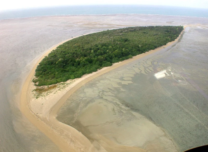
An aerial view of a low lying tropical island surrounded by expansive tidal sandflats and shallow reef environments.
Aerial view of Deliverance Island, the primary feature of the Warul Kawa Indigenous Protected Area.

Warul Kawa Indigenous Protected Area history and protected-area timeline

Warul Kawa, known to European visitors as Deliverance Island, has had a layered human history despite its remote location. The island has been inhabited periodically by Europeans, although such stays were intermittent and left only a limited footprint on the natural environment. This is reflected today in the very low number of recorded exotic plant species and the overall retention of vegetation integrity on the cay.

Among the more unusual episodes in the island's history is the residence of "German Harry," the Somerset Maugham character inspired by a real Danish mariner. Known in real life as Old Harry and christened Johannes Henrik Enevoldsen, he lived on the island as a hermit from about 1888 until his death in 1928, occupying the cay during its period of more regular European contact.

The decisive moment in the island's modern history came in February 2001, when Deliverance Island was formally declared an Indigenous Protected Area under Australia's National Reserve System. The declaration reflected both the continuing spiritual and cultural connection of local Torres Strait Islanders to Warul Kawa and recognition of the island's outstanding natural values. Since then, the IPA has stood as a formal recognition of Indigenous-led protection for one of the most remote and ecologically significant cays in the Torres Strait.

Warul Kawa Indigenous Protected Area landscape and geographic character

Warul Kawa is a low-lying sand cay, the kind of small, flat island typical of the far north-western Torres Strait. There are no forested ranges, cliffs, or inland mesas; the landscape is defined by sandy terrestrial ground, a reef shelf, and the surrounding sea. The cay sits within a shallow reef platform interspersed with sandy patches, where rocky substrate supports extensive growths of brown and green algae and isolated patches of seagrass.

Live coral is present but limited, and the visual character of the marine landscape is dominated by algal cover, sand, and shallow water rather than classic reef-building structures. This reef platform, combined with the cay itself, forms the physical footprint of the protected area. The shallow-water setting shapes both the island's exposure to weather and its ecological function as turtle and seabird habitat.

Seen from the north, as in the well-known Deliverance Island photograph from 2002, the cay appears as a small strip of sand above a wide, shallow reef flat opening onto deeper Torres Strait waters. This combination of low island, broad shallow reef, and open sea is what gives Warul Kawa its distinctive Torres Strait character, distinguishing it from the larger, more inhabited islands further south in the strait.

Warul Kawa Indigenous Protected Area ecosystems, habitats, and plant life

The natural character of Warul Kawa is shaped by its position as a small sand cay embedded in a tropical reef environment. Terrestrial habitats cover only a limited area, but they exhibit high vegetation integrity, considerable plant diversity, and a notable absence of invasive species. Only two exotic plant species have been recorded on the island, a reflection of the limited and intermittent European presence and the area's general remoteness.

Marine habitats dominate the protected area. The reef platform around the cay is shallow and largely built of rocky substrate covered in brown and green algae, with seagrass patches and limited live coral. Sandy patches intersperse the platform, creating a mosaic of substrate types that support different forms of marine life. The combination of clean shallow water, abundant algal forage, and undisturbed seafloor is what makes the area valuable for large marine animals, particularly sea turtles and the birds that depend on the island.

At an ecosystem scale, Warul Kawa represents a near-intact example of a Torres Strait sand cay and adjacent reef platform. Its remoteness and minimal history of human disturbance have allowed ecological processes such as turtle nesting and seabird use of the cay to continue largely unimpeded, lending the protected area a high natural value relative to more heavily visited locations in the region.

Warul Kawa Indigenous Protected Area wildlife and species highlights

The wildlife of Warul Kawa is dominated by marine and island-associated species rather than terrestrial mammals or large predators. Sea turtles are the area's most significant faunal feature. The island and reef support two internationally important turtle populations, with one of the largest rookeries of the flatback turtle in Australia found here. The extensive shallow-water habitats around the cay also support large numbers of migrating green turtles, and the broader north and eastern Australian breeding assemblages of which Warul Kawa is a part are among the largest remaining rookeries for green turtles in the region.

The island's birdlife adds another layer to its ecological importance. Thirty-three species of birds have been recorded, making it a notable site for avian diversity in the Torres Strait. Among these is the yellow-footed scrubfowl, a species that has not been reported on many other islands of the strait, suggesting that Warul Kawa retains habitat conditions that other islands in the region have lost.

Because the cay has experienced only limited human disturbance, the wildlife values of both the marine and terrestrial environments remain largely intact. The interaction between nesting turtles, reef-associated marine life, and island bird populations defines the broader character of the protected area, even though specific species checklists are not the focus of the IPA's recognition.

Warul Kawa Indigenous Protected Area conservation status and protection priorities

Warul Kawa's conservation significance lies in the combination of largely undisturbed marine and island habitats and globally important wildlife populations. The protected area contains one of the largest remaining flatback turtle rookeries in Australia and contributes to some of the largest remaining green turtle breeding assemblages in the region. The presence of these turtles, whose populations have declined across much of their range, gives the IPA particular international significance.

On land, the very low number of recorded exotic plant species and the continuing high vegetation integrity point to an island that has escaped many of the pressures affecting more accessible Torres Strait islands. The mixture of algal reef, seagrass, and sand, while not supporting extensive live coral cover, has nonetheless retained the structural and biological features needed to support turtle and bird populations. This intactness, rather than any single species or habitat, is the broader measure of the area's conservation value.

The Indigenous Protected Area declaration of February 2001 placed these natural values under Indigenous-led protection within Australia's National Reserve System. The status recognises both the cultural continuity of Torres Strait Islanders with Warul Kawa and the role of the island as a refuge for species and habitats that would otherwise be vulnerable in a more heavily visited region. In conservation terms, the IPA functions simultaneously as a refuge for internationally significant turtle populations and as a model of Indigenous governance over a remote marine and island environment.

Warul Kawa Indigenous Protected Area cultural meaning and human context

Warul Kawa is culturally significant to local Torres Strait Islanders, whose name for the island, Warul Kawa, means "Island of turtles" and reflects both the natural prominence of turtles in the surrounding waters and the spiritual value the place holds. This long-standing cultural connection provided the basis for the Indigenous Protected Area declaration in 2001, formalising the Indigenous relationship with the cay within a national protection framework.

European contact with Deliverance Island left a less continuous but still notable imprint. The island was periodically inhabited by Europeans, most famously by the Danish mariner Old Harry, who lived as a hermit on the cay from about 1888 until his death in 1928. The character later inspired by this figure appeared in Somerset Maugham's Cosmopolitans, giving the otherwise remote island a small place in twentieth-century literary imagination.

Today, the cultural identity of Warul Kawa is anchored in its Torres Strait Islander name and its continuing role as a protected place of Indigenous significance. The IPA status allows this cultural relationship and the island's conservation values to be managed together, rather than treated as separate concerns.

Top sights and standout views in Warul Kawa Indigenous Protected Area

Warul Kawa stands out within the Torres Strait for the unusual combination of near-pristine marine environment and Indigenous-led protection. Its reef platform, though limited in live coral, supports extensive algal growth and seagrass in clean shallow water, and it hosts one of the largest flatback turtle rookeries in Australia. Migrating green turtles also use the surrounding waters in significant numbers, linking the IPA to the broader north Australian breeding system for the species.

Equally distinctive is the island's terrestrial condition. Despite a history of periodic European habitation, Warul Kawa retains high vegetation integrity and has only two recorded exotic plant species. Thirty-three bird species are present, including the yellow-footed scrubfowl, which is rare on other Torres Strait islands. Together, the turtle populations, the intact vegetation, and the Indigenous Protected Area declaration make Warul Kawa one of the most ecologically and culturally significant small islands in northern Australian waters.

Best time to visit Warul Kawa Indigenous Protected Area

As a remote, low-lying sand cay in the Torres Strait, Warul Kawa is shaped by tropical northern Australian conditions, with warm temperatures year-round and a clear distinction between a drier season and a wetter monsoon-influenced season. Conditions on and around the island are most stable during the drier months, when lower rainfall and calmer seas make reef and cay environments easier to access and observe. The wetter season brings heavier rain, stronger winds, and more variable sea conditions, which can affect both access and visibility in the shallow reef waters around the cay.

For visitors focused on the area's wildlife, the timing of turtle nesting and migration is particularly relevant. Flatback turtle nesting and green turtle movements in the region peak during specific warmer months, when conditions on the cay and adjacent reef suit reproduction and feeding. Because the IPA is managed primarily for conservation and cultural protection rather than regular public access, any visit should be understood as occurring within a framework that prioritises these values, and seasonality should be considered in the context of the protected area's remoteness and weather patterns.

Monthly climate preview

Long-term monthly temperature and precipitation rhythm for Warul Kawa Indigenous Protected Area

Warul Kawa Indigenous Protected Area Climate Normals and Temperature Patterns

Historical climatology records for Warul Kawa Indigenous Protected Area show a consistent annual cycle of sustained warm temperatures alongside distinct shifts in monthly precipitation rates. Analyzing the complete twelve-month profile provides deeper insight into measured baseline conditions across the protected area coordinate.
Annual mean27 °C
25 °C28 °C
Jan28°
Feb28°
Mar28°
Apr28°
May27°
Jun26°
Jul25°
Aug25°
Sep26°
Oct27°
Nov28°
Dec28°
Warmest month
December

28.5 °C

Coolest month
August

25 °C

Wettest month
February

11.8 mm/day

Driest month
September

0.5 mm/day

Park location guide

Geography guide, regional context, and park location map for Warul Kawa Indigenous Protected Area

Warul Kawa Indigenous Protected Area park geography, regions, and map view in Australia

Understand where Warul Kawa Indigenous Protected Area sits in Australia through a broader geographic reading of the surrounding landscape, nearby location context, and its mapped position within the national park landscape.

How Warul Kawa Indigenous Protected Area fits into Australia

Australia is a constitutional monarchy and federal parliamentary democracy comprising six states and ten territories. With a population of nearly 28 million, it is one of the world's most urbanised countries, with most people concentrated on the eastern seaboard. The country has a high Human Development Index and is known for its cultural diversity, ancient Aboriginal heritage, and unique wildlife.

Wider geography shaping Warul Kawa Indigenous Protected Area in Australia

Australia occupies the entire Australian continent, the island of Tasmania, and numerous smaller islands. It is the world's flattest and driest inhabited continent, featuring vast deserts in the interior (the Outback), tropical rainforests along the eastern coast, and a coastline bordering the Indian and Pacific Oceans.

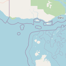
Map view of Warul Kawa Indigenous Protected Area

Use this park location map to pinpoint Warul Kawa Indigenous Protected Area in Australia, understand its exact geographic position, and read its mapped placement within the surrounding landscape more clearly.

Pigeon | © OpenStreetMap contributors

Location context for Warul Kawa Indigenous Protected Area

Queensland

Visual reference for sand cay terrain, shallow reef flats, and remote marine habitats

Warul Kawa Indigenous Protected Area Photos and Landscape Scenery

Visual documentation reveals the distinctive terrain of Warul Kawa Indigenous Protected Area through imagery of its low sand cay and shallow reef platform. Photographic records capture the remote marine environment, native vegetation integrity, and protected habitats that define this northern island.

An aerial view of a low lying tropical island surrounded by expansive tidal sandflats and shallow reef environments.

Park atlas

Compare regional marine habitats and neighboring northern Australian protected areas.

Explore Other Parks Near Warul Kawa Indigenous Protected Area and Surrounding Protected Landscapes

Browse related protected areas and coastal reserves situated across the wider Torres Strait region. Continuing onward from Warul Kawa Indigenous Protected Area allows for deeper comparison of remote island ecosystems and tropical marine geography.
Wildlife reserveWestern Province
About 57 km away#1 closest

North

Tonda Wildlife Management Area: Atlas of Protected Wetlands and Savanna Landscapes

Geographic overview of Papua New Guinea's largest wetland conservation zone

Spanning nearly 6,000 square kilometres of floodplain, Tonda Wildlife Management Area is defined by its exceptionally flat terrain and shifting mosaic of monsoon forest, tidal channels, and freshwater marshes. This protected landscape functions as an essential ecological bridge within the Trans-Fly ecoregion, maintaining deep connections to international conservation partners while preserving the integrity of its native bird and mammal habitats.

Area
5,900 km²
Established
1975
National parkSouth Papua
About 74 km away#2 closest

Northwest

Wasur National Park National Park: Mapped Protected Boundaries in South Papua

Explore the geographic context and park boundaries.

Delve into the specific protected area identity of Wasur National Park, a national park situated within the South Papua region. This page offers detailed geographic context, focusing on its mapped boundaries and its significance as a protected landscape. It provides a factual basis for understanding the park's place within Indonesia's network of natural areas for structured atlas exploration.

Area
4,138 km²
Established
1990
IUCN
II
Visitors
2.3K annual
National parkAustralia
About 161 km away#3 closest

Southeast

Possession Island National Park: National Park Atlas and Mapped Geographic Context

Australia's protected natural terrain and park boundaries.

Possession Island National Park serves as a vital point of discovery for understanding Australia's protected lands. This national park provides detailed insights into its specific geographic setting and landscape character, contributing to a broader atlas of natural territories. Engage with its mapped boundaries and unique terrain to grasp its significance within the country's conservation landscape. It is an essential component for anyone exploring the geography of Australian national parks.

A wide watercolor illustration showing green hills in the distance, a body of shallow water with pink and green patches, and foreground vegetation including green grasses and pink coral-like structures.
Marine protected areaQueensland
About 167 km away#4 closest

Southeast

Great Barrier Reef Marine Park: Atlas and Geographic Context for Queensland Protected Waters

Exploring the reef system and marine conservation zones in northeastern Australia

The Great Barrier Reef Marine Park stands as an internationally significant marine protected area. By spanning a massive stretch of the Queensland coast, this protected landscape provides a critical framework for marine governance and reef conservation. Users can examine the unique zoning and distribution of coral reef habitats that define this extensive tropical ecosystem.

Area
343,966 km²
Established
1975
Climate
Tropical
Scope
Marine
Marine protected areaQueensland
About 167 km away#5 closest

South

West Cape York Marine Park: Atlas and Geographic Context for Queensland Marine Reserves

Protected marine habitats in the Gulf of Carpentaria

Examine the extensive marine landscape of West Cape York Marine Park, a key component of the North Marine Parks Network. This protected area features deep basin waters and productive shelf margins that serve as a transition zone between the Gulf of Carpentaria and the Torres Strait, safeguarding high biodiversity levels.

Area
16,012 km²
Established
2018
IUCN
IV
Relief
Lowland
National parkQueensland
About 228 km away#6 closest

Southeast

Apudthama National Park: Queensland National Park Protected Landscape Geography

Explore the mapped boundaries and regional context.

Apudthama National Park offers a distinct national park experience within Queensland, Australia, focusing on its protected area identity and geographic landscape. This entry provides critical atlas-level information, detailing the park's mapped boundaries and its position within the regional geography. Understand the specific natural terrain and conservation context of this significant protected land.

Area
2,370 km²
Established
1994
IUCN
II
Relief
Lowland
National parkAustralia
About 237 km away#7 closest

Southeast

Yamarrinh Wachangan Islands (Denham Group) National Park: Australian Protected Landscape Map and Geography

Mapped boundaries and regional geographic context within Australia.

This detail entry for Yamarrinh Wachangan Islands (Denham Group) National Park provides specific geographic context and atlas information for this Australian national park. It focuses on the protected landscape identity, mapped features, and regional setting, offering a factual foundation for understanding the park's place within Australia's protected areas network. Explore its unique geographic characteristics and its designation as a national park.

National parkQueensland
About 289 km away#8 closest

Southeast

Saunders Islands National Park: National Park Geography and Mapped Protected Landscape in Queensland

Explore the mapped terrain and protected area context.

Saunders Islands National Park represents a significant protected area within the geography of Queensland, Australia. This entry provides detailed atlas-level insights into its specific geographic boundaries and the nature of its protected landscape. Users can understand the park's regional placement and its mapped natural terrain, offering a concrete point for exploring Queensland's diverse protected lands and their unique environmental characteristics.

Area
0.19 km²
Established
1989
IUCN
II
Climate
Tropical

Common questions about visiting, size, designation, and location context for Warul Kawa Indigenous Protected Area

Warul Kawa Indigenous Protected Area FAQs for park facts, access, geography, and protected area context

Find quick answers about Warul Kawa Indigenous Protected Area, including protected-area facts, park geography, trail and visitor context, and how the park fits into its surrounding country and regional landscape.
MoriAtlas Explorer

Continue Your Protected Areas Search Across the Global Atlas

Deepen your exploration by continuing the structured search for national parks and protected areas worldwide. Utilize the comprehensive filtering capabilities to compare different conservation landscapes and refine your understanding of global park geography. Discover more about the distribution and characteristics of protected natural areas.

Global natural geography

