
Mori Atlas logo
Nature reserveWellier Schleife/Staustufe Landesbergen

A detailed geographic study of oxbow channels, gravel pit lakes, and floodplain habitats in Lower Saxony.

Wellier Schleife/Staustufe Landesbergen Nature Reserve and Protected Weser River Valley Landscapes

(Naturschutzgebiet Wellier Schleife/Staustufe Landesbergen)

Wellier Schleife/Staustufe Landesbergen provides a protected look into the engineered history of the Middle Weser valley. Established to preserve the oxbow arm formed by the construction of the Landesbergen weir, this 278-hectare nature reserve encompasses a mosaic of wetland edges, former gravel extraction pits, and surrounding agricultural floodplain. The site sits within a broader network of bird protection and habitat areas, serving as a critical corridor for aquatic and shoreline-dependent species near Nienburg.

river oxbowWeser floodplainwetlandformer gravel pitsbird protection areaHabitats Directive site
A stylized digital illustration showing a winding river through a grassy landscape at sunset, with a line of trees in the background and reeds in the foreground.

Wellier Schleife/Staustufe Landesbergen

Nature reserve

Park overview

Structured park overview, official facts, and landscape profile for Wellier Schleife/Staustufe Landesbergen

Wellier Schleife/Staustufe Landesbergen park facts, protected area profile, and essential visitor context

Review the core facts for Wellier Schleife/Staustufe Landesbergen, including designation, size, terrain, visitor scale, habitats, and operating context in one park-focused overview.

About Wellier Schleife/Staustufe Landesbergen

Wellier Schleife/Staustufe Landesbergen is a nature reserve in the Middle Weser region of Lower Saxony, situated within the Landkreis Nienburg/Weser. Officially designated since 1996 under the code NSG HA 177, it encompasses 278 hectares of floodplain landscape shaped by both the natural history of the River Weser and modern hydraulic engineering along the waterway.

At the heart of the protected area is the Wellier Schleife, an oxbow arm of the Weser. This former side channel was cut off from the main river flow when the Staustufe Landesbergen was built in 1959 and 1960 to regulate the waterway. Since then, the Schleife has developed as a quieter, partially separated water body. Above the weir it is fully detached from the Weser, while below it remains connected to the river through a low sill. The protected area extends from the Schleife itself to its shorelines and across the agricultural and semi-natural land between the old arm and the current Weser bed.

The reserve also includes a section of the island lying between the lock and weir of the Staustufe Landesbergen, integrating this engineered landscape element into the broader conservation framework. In administrative terms, the site spans several local government areas: Estorf and Landesbergen in the Samtgemeinde Mittelweser, Liebenau in the Samtgemeinde Weser-Aue, and Steyerberg.

Ecologically, the reserve's main function is to preserve and develop the near-natural character of the Wellier Schleife, including its shoreline habitats and the mosaic of surrounding land uses. Part of the protected area largely continues to be farmed as arable land, but two former gravel pits now connected to the Schleife, along with adjacent grassland, bring a meaningful diversity of wetland, open water, and terrestrial habitats into the site.

Quick facts and research context for Wellier Schleife/Staustufe Landesbergen

Wellier Schleife/Staustufe Landesbergen is a 278-hectare nature reserve in Lower Saxony, classified under IUCN Category IV as a Habitat/Species Management Area. It is designated NSG HA 177 and has been protected since 11 April 1996.

The reserve lies in the Middle Weser region east of Wellie, south of Liebenau, and northwest of Landesbergen, within the Landkreis Nienburg/Weser. It is largely part of the EU Bird Protection Area "Wesertalaue bei Landesbergen" and partially overlaps with the FFH area focused on pond bat waters near Nienburg.

Protection and recognition

Examine terrestrial protected area designation details and management scope

Wellier Schleife/Staustufe Landesbergen Protection Status and Recognition

Documented protection status and international recognition data outline the management scope for Wellier Schleife/Staustufe Landesbergen. Verified records provide clear baseline facts regarding terrestrial protected area designation parameters.

Protection details

Protection scope
Terrestrial
Transboundary protection
No
WDPA ID
166239
Park context

Deeper park guide and search-rich context for Wellier Schleife/Staustufe Landesbergen

Wellier Schleife/Staustufe Landesbergen history, landscape, wildlife, and travel context

Explore Wellier Schleife/Staustufe Landesbergen through its history, landscape character, ecosystems, wildlife, conservation priorities, cultural context, and seasonal travel timing in a structured park guide built for atlas discovery and search intent.

Why Wellier Schleife/Staustufe Landesbergen stands out

The reserve is best known for protecting the Wellier Schleife, a former channel of the Weser that became an oxbow arm after the construction of the Landesbergen weir in 1959 and 1960. Its location within the larger Weser valley bird protection area makes it significant for waterway and floodplain birdlife, while former gravel pits linked to the old arm add additional aquatic and shoreline habitat value.
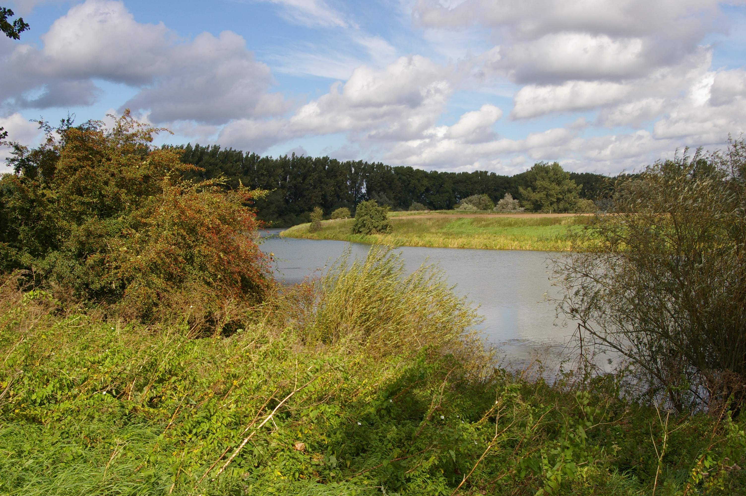
A peaceful oxbow lake surrounded by lush green riparian vegetation under a cloudy sky.
The Wellier Schleife, a calm oxbow lake of the Weser river in Lower Saxony.

Wellier Schleife/Staustufe Landesbergen history and protected-area timeline

The landscape protected in Wellier Schleife/Staustufe Landesbergen was substantially shaped in the late 1950s and early 1960s, when the Staustufe Landesbergen was constructed along the Weser in 1959 and 1960. This infrastructure project transformed an existing meander or side channel into the Wellier Schleife, an oxbow arm disconnected from the main river above the weir and only loosely reconnected below it through a sill.

More than three decades later, on 11 April 1996, the area was formally placed under nature conservation protection as the Naturschutzgebiet Wellier Schleife/Staustufe Landesbergen, designated with the code NSG HA 177. The reserve was recognised as ecologically valuable both for its newly formed oxbow habitats and for its position within the wider Weser floodplain. It was also integrated into larger European conservation frameworks, primarily as part of the EU Bird Protection Area "Wesertalaue bei Landesbergen" and partly within the Habitats Directive site for pond bat waters near Nienburg.

Since its designation, the reserve has been cared for under the oversight of the Landkreis Nienburg/Weser as the responsible lower nature conservation authority, with the Nienburg district association of the Naturschutzbund Deutschland (NABU) contributing to its on-the-ground stewardship.

Wellier Schleife/Staustufe Landesbergen landscape and geographic character

The landscape of Wellier Schleife/Staustufe Landesbergen is defined by the interplay between a regulated river and the quieter waters left behind by that regulation. The central feature is the Wellier Schleife, the oxbow arm of the Weser that was created when the Staustufe Landesbergen was built; above the weir, this old channel sits apart from the Weser as a semi-isolated water body, while below the weir a shallow sill maintains a partial connection.

Around the Schleife, low-lying riverbanks and the broader floodplain of the Middle Weser shape the terrain, with elevation in the reserve ranging from roughly 25 to 30 meters above sea level. Much of the land between the oxbow and the present Weser channel is flat agricultural country, today mostly used for arable farming. Two former gravel pits, now open water bodies linked to the Schleife, introduce additional shoreline and pit-lake character into the area.

The reserve also incorporates a portion of the island lying between the lock and weir of the Staustufe Landesbergen, sitting within the engineered infrastructure of the waterway. Adjoining the gravel pits are patches of grassland that soften the boundary between open water, former extraction sites, and the cultivated floodplain, creating a mosaic of water, wetland edge, meadow, and farmland typical of the Middle Weser valley.

Wellier Schleife/Staustufe Landesbergen ecosystems, habitats, and plant life

The reserve's ecological identity revolves around the Wellier Schleife and its associated shoreline and floodplain habitats. The oxbow arm and its banks form the core near-natural ecosystem that protection efforts focus on, combining slow-moving or still freshwater with fringing wetland vegetation characteristic of the Middle Weser.

The mosaic extends beyond the water itself. Former gravel pits, now hydraulically connected to the Schleife, contribute additional standing-water and shore habitats, while adjacent grassland patches provide open terrestrial habitat that complements the wetter zones. The wider floodplain, although largely under arable cultivation, retains the spatial structure of a typical Weser valley landscape, with cultivated land, meadows, standing water, and riparian features in close proximity.

At a broader scale, the area is recognised as part of the EU Birds Directive site "Wesertalaue bei Landesbergen", placing the nature reserve within a larger network of habitats important for birds of the Weser floodplain. A smaller portion of the protected area also falls within the Habitats Directive area "Teichfledermaus-Gewässer im Raum Nienburg", highlighting the importance of its water bodies for pond bat populations alongside their broader ecological role.

Wellier Schleife/Staustufe Landesbergen wildlife and species highlights

The Wellier Schleife/Staustufe Landesbergen reserve is most strongly associated with birds of the Weser floodplain, as the site forms a substantial part of the EU Bird Protection Area "Wesertalaue bei Landesbergen". The combination of open water in the oxbow and former gravel pits, fringing shoreline vegetation, adjacent grassland, and the broader cultivated floodplain provides a range of habitats used by waterway and farmland bird species typical of the Middle Weser.

Alongside its bird significance, part of the reserve overlaps with the Habitats Directive site "Teichfledermaus-Gewässer im Raum Nienburg", meaning that the connected water bodies of the Schleife and the gravel pits also contribute to habitat for pond bats in the Nienburg area. The mix of open water, dead-wood and shoreline edges within and around the former gravel pits likely supports bat foraging and commuting, as well as a wider community of wetland-associated invertebrates and other fauna typical of similar Middle Weser sites.

Wellier Schleife/Staustufe Landesbergen conservation status and protection priorities

The reserve's central conservation goal is the preservation and development of the near-natural ecosystem of the Wellier Schleife and its shores, anchoring habitat protection for what is essentially a human-influenced but ecologically valuable Weser oxbow. By formally protecting the Schleife, its banks, the land between the old arm and the current river, and part of the Staustufe island, the designation safeguards a coherent floodplain unit rather than an isolated patch.

Recognition at the European level further strengthens the site's conservation profile. The bulk of the reserve is part of the EU Birds Directive protection area "Wesertalaue bei Landesbergen", anchoring it in the network of important bird areas along the Weser. A smaller portion lies within the Habitats Directive area "Teichfledermaus-Gewässer im Raum Nienburg", giving the connected water bodies an explicit role in bat conservation.

On the ground, protection has been in force since 11 April 1996 under the Natura 2000 framework's domestic implementation, and stewardship is shared between the Landkreis Nienburg/Weser as the responsible lower nature conservation authority and the Nienburg district association of NABU, linking formal oversight with active local conservation engagement.

Top sights and standout views in Wellier Schleife/Staustufe Landesbergen

The reserve protects a human-engineered yet ecologically valuable oxbow of the Weser, the Wellier Schleife, created by the 1959/1960 construction of the Staustufe Landesbergen and subsequently brought under formal nature protection in 1996. Its 278 hectares combine still and slow-moving water, shoreline habitats, former gravel pits, grassland, and arable floodplain within a single, coherent Middle Weser landscape.

Its integration into the EU Bird Protection Area "Wesertalaue bei Landesbergen" and partial overlap with the Habitats Directive site for pond bat waters near Nienburg place it firmly within the wider Lower Saxon conservation network, while the unusual mix of working farmland, gravel-pit lakes, and an oxbow arm gives the site a distinctive cultural-ecological character shaped by both river engineering and active land use.

Monthly climate preview

Long-term monthly averages tracking temperature ranges and precipitation patterns across the protected landscape

Wellier Schleife and Staustufe Landesbergen Climate Normals and Annual Temperature Rhythm

Representative coordinate records show average temperatures ranging from winter lows below freezing to summer maximums near thirty degrees, alongside consistent monthly precipitation distribution. Reviewing the complete twelve-month climatology data provides deeper context on long-term weather patterns and temperature transitions across the protected area.
Annual mean9 °C
1 °C18 °C
Jan
Feb
Mar
Apr
May13°
Jun16°
Jul18°
Aug18°
Sep14°
Oct10°
Nov
Dec
Warmest month
July

18.4 °C

Coolest month
January

0.6 °C

Wettest month
July

2.4 mm/day

Driest month
April

1.4 mm/day

Park location guide

Geography guide, regional context, and park location map for Wellier Schleife/Staustufe Landesbergen

Wellier Schleife/Staustufe Landesbergen park geography, regions, and map view in Germany

Understand where Wellier Schleife/Staustufe Landesbergen sits in Germany through a broader geographic reading of the surrounding landscape, nearby location context, and its mapped position within the national park landscape.

How Wellier Schleife/Staustufe Landesbergen fits into Germany

Germany is a federal republic in Western and Central Europe with a population of over 83 million across sixteen constituent states. It is Europe's largest economy by nominal GDP and a major global exporter and importer. The capital is Berlin, and the country borders Denmark, Poland, Czech Republic, Austria, Switzerland, France, Luxembourg, Belgium, and the Netherlands.

Wider geography shaping Wellier Schleife/Staustufe Landesbergen in Germany

Germany is located in Western and Central Europe, spanning 357,022 km². It borders Denmark to the north, Poland and the Czech Republic to the east, Austria and Switzerland to the south, and France, Luxembourg, Belgium, and the Netherlands to the west. The country has coastlines on the Baltic Sea and North Sea to the north, with the Alps located in the southern region.

Map view of Wellier Schleife/Staustufe Landesbergen

Use this park location map to pinpoint Wellier Schleife/Staustufe Landesbergen in Germany, understand its exact geographic position, and read its mapped placement within the surrounding landscape more clearly.

Pigeon | © OpenStreetMap contributors

Location context for Wellier Schleife/Staustufe Landesbergen

Nienburg/Weser

Visualizing the river oxbow, floodplain habitats, and water environments of Lower Saxony

Wellier Schleife/Staustufe Landesbergen Photos, Scenery, and Protected Landscape Views

Visual documentation of Wellier Schleife/Staustufe Landesbergen reveals the distinct terrain of the Middle Weser floodplain, including the protected oxbow arm and surrounding wetland margins. Examining these photographs allows researchers to interpret the habitat mosaic, former gravel pit waters, and river engineering character defining the reserve.

A peaceful oxbow lake surrounded by lush green riparian vegetation under a cloudy sky.

Park atlas

Discover adjacent nature reserves, river valleys, and connected protected landscapes in the region.

Explore Parks Near Wellier Schleife/Staustufe Landesbergen and Surrounding Protected Areas

Continue geographic comparison by browsing other protected areas sharing similar floodplain and wetland terrain near Wellier Schleife/Staustufe Landesbergen. Expanding regional park discovery reveals how regulated river networks shape conservation lands across the wider valley.
Nature reserveLower Saxony
About 6.6 km away#1 closest

Southeast

Steinhuder Meer mit Randbereichen: Protected Nature Reserve and Wetland Geography

Lowland lake, fen meadows, and bog ecosystems in Lower Saxony

Steinhuder Meer mit Randbereichen stands as a primary conservation site in northwestern Germany. The protected landscape combines a vast, shallow lowland lake with extensive reed belts and peatland remnants, creating a complex wetland gradient that defines the regional geography of the Weser-Aller lowlands.

Area
53.71 km²
Established
2004
Nature reserveNordrhein-Westfalen
About 18 km away#2 closest

South

Weseraue Nature Reserve and Weser River Floodplain Geographic Overview

Protected wetland landscapes in North Rhine-Westphalia

The Weseraue landscape encompasses 25 kilometers of the Weser river corridor, characterized by its diverse mix of dammed sections, natural flow channels, and seasonal wet grasslands. As a cornerstone of the Natura 2000 network, it provides essential habitat for breeding and migratory species, serving as a primary refuge within the North Rhine-Westphalia floodplain geography.

Area
27.438 km²
Established
1983
Relief
Lowland
Scope
Terrestrial
Nature reserveLower Saxony
About 18 km away#3 closest

Southeast

Westufer Steinhuder Meer Nature Reserve: Geographic Profile and Wetland Boundaries

Protected mosaic of swamp forest and bog in Lower Saxony

Westufer Steinhuder Meer represents a significant wetland complex within the Natura 2000 network of Lower Saxony. The protected area features a unique concentric gradient ranging from lakeshore reedbeds to inland fen and bog forest. By mapping these interconnected peat habitats, the reserve highlights its role as a key stopover for migratory waterfowl and a sanctuary for rare breeding species on the North German Plain.

Area
6.63 km²
Established
2020
Nature reserveLandkreis Nienburg/Weser
About 23 km away#4 closest

Northeast

Weißer Graben Nature Reserve: Mapped Protected Landscapes in Landkreis Nienburg/Weser

Peatland regeneration and meadow bird habitat boundaries

Located within the flat terrain of the northern German lowlands, Weißer Graben serves as a prime example of successful peatland renaturation and wet grassland management. The site structure contrasts recovering industrial peat cuttings with intact birch swamp forests and varied meadow patterns. This entry provides geographic context on the reserve boundaries, the role of local waterways in hydrologic maintenance, and its placement within the larger Lichtenmoor complex.

Area
5.02 km²
Established
1995
IUCN
IV
A horizontal watercolor painting depicting a soft, impressionistic forest landscape with green trees, subtle hints of pink and purple, and a light background.
Nature reserveNorth Rhine-Westphalia
About 24 km away#5 closest

Southwest

Heisterholz: Protected Oak Forests and Wetland Mosaics in North Rhine-Westphalia

Geographic overview of a key nature reserve and forest belt

Explore the structured geography of Heisterholz, a state-protected lowland forest in the Rahden-Diepenauer Geest. This site details the composition of its oak-dominated woodlands, spring zones, and stream valleys, illustrating its critical function within the interconnected forest chain of northern Germany.

Area
8.8 km²
Relief
Lowland
Climate
Temperate
Scope
Terrestrial
Watercolor illustration of a peaceful lakeside scene at Lahder Marsch, featuring birch trees, marshy vegetation, and a calm water surface.
Nature reserveKreis Minden-Lübbecke
About 25 km away#6 closest

South

Lahder Marsch Nature Reserve: Protected Wetland Mosaic in Kreis Minden-Lübbecke

A mapped sanctuary for migratory birds within the Weser floodplain.

Lahder Marsch is a designated nature reserve located in the Weser river valley, forming a chain of flooded gravel pits that sustain diverse avian populations. This protected landscape, characterized by open water, islands, and dense reed fringes, serves as a crucial habitat within the larger Weseraue Natura 2000 network, illustrating the geographic importance of restored extraction sites in lowland Germany.

Area
0.19 km²
Water
Major water bodies
A wide watercolor illustration showing a misty landscape with soft purple mountains in the distance and pink and green grasses in the foreground against a white background.
Nature reserveGermany
About 25 km away#7 closest

West

Steinbrinker-Ströhener Masch: Nature Reserve and Wetland Protected Area in Lower Saxony

Mapping the fen peat grasslands and moorland buffers of Germany.

Steinbrinker-Ströhener Masch is an essential protected site in northwestern Germany, characterized by low-lying fen peat soils and expansive wet grasslands. Functioning as a key link within the Diepholzer Moorniederung, the area preserves critical habitat for meadow-breeding birds, shaped by seasonal waterlogging and traditional low-intensity land management techniques.

Area
3.25 km²
Established
1991
Relief
Lowland
Climate
Temperate
Nature reserveLower Saxony
About 26 km away#8 closest

North

Wiedesee Nature Reserve: Mapped Geography and Protected Landscapes in Lower Saxony

A compact waterbird habitat in the Lower Saxony agricultural region

Wiedesee stands as a refined example of a managed nature reserve in Germany. Spanning 26 hectares, this former quarrying lake is defined by its concentric transition from open water and reed belts to wet meadow fringes. The site serves as a vital island of biodiversity, offering a clear case study in how active conservation interventions support migratory bird species within an otherwise intensively farmed landscape.

Area
0.26 km²
Established
1984
Water
Water-dominated

Common questions about visiting, size, designation, and location context for Wellier Schleife/Staustufe Landesbergen

Wellier Schleife/Staustufe Landesbergen FAQs for park facts, access, geography, and protected area context

Find quick answers about Wellier Schleife/Staustufe Landesbergen, including protected-area facts, park geography, trail and visitor context, and how the park fits into its surrounding country and regional landscape.
MoriAtlas Explorer

Continue Your Protected Areas Search Across the Global Atlas

Deepen your exploration by continuing the structured search for national parks and protected areas worldwide. Utilize the comprehensive filtering capabilities to compare different conservation landscapes and refine your understanding of global park geography. Discover more about the distribution and characteristics of protected natural areas.

Global natural geography