
Mori Atlas logo
Protected landscapeWelzheimer Wald mit Leintal

Tracing the mapped boundaries of a contiguous low mountain forest and valley system

Welzheimer Wald mit Leintal Protected Landscape and Eastern Swabian Keuper Forest Geography

(Landschaftsschutzgebiet „Welzheimer Wald mit Leintal")

Welzheimer Wald mit Leintal represents a significant protected landscape spanning the eastern Swabian Keuper hill country within the Ostalbkreis region of Germany. This extensive area safeguards over nine thousand hectares of continuous forest and river valley terrain. By bridging the natural regions of the Schurwald, the Swabian-Franconian Forest, and the Welzheimer Wald, the area maintains a distinct topographic character defined by its gentle ridges and deeply incised stream valleys.

Landschaftsschutzgebietprotected landscapeSwabian forestKeuper uplandsmixed woodlandlow mountain landscape
Digital vector illustration of a mountain valley with a waterfall flowing into a river, surrounded by evergreen forests, under a sun-filled sky.

Welzheimer Wald mit Leintal

Protected landscape

Park overview

Structured park overview, official facts, and landscape profile for Welzheimer Wald mit Leintal

Welzheimer Wald mit Leintal park facts, protected area profile, and essential visitor context

Review the core facts for Welzheimer Wald mit Leintal, including designation, size, terrain, visitor scale, habitats, and operating context in one park-focused overview.

About Welzheimer Wald mit Leintal

Welzheimer Wald mit Leintal is a state-level protected landscape in Baden-Württemberg, Germany, that safeguards a substantial block of Keuper forest and valley terrain on the eastern edge of the Swabian low mountain country. It was designated on 30 August 1972 by the then Regierungspräsidium Nordwürttemberg and is administered jointly by the Ostalbkreis and the Rems-Murr-Kreis. The protection area extends in an elongated east-west band between the town of Welzheim in the west and the community of Heuchlingen in the east, linking forested ridges and valleys that form the upper catchment of the Lein river as well as parts of nearby drainage systems.

The landscape belongs to a well-defined geological and natural-region context. Geologically, the area sits within the Schwäbisches Keuper-Lias-Land, a large natural region built largely on Triassic Keuper sedimentary rocks that weather into the mixed forest soils typical of eastern Baden-Württemberg. Within that larger region, the protection area is placed at the interface of two sub-regions: the Schurwald and Welzheimer Wald (107), a wooded escarpment and highland area running west-southwest of Schwäbisch Gmünd, and the Schwäbisch-Fränkische Waldberge (108), the forested ridge-and-valley belt that extends northeast into the Swabian-Franconian borderlands. This intermediate position gives the area a transitional character, with landforms, soils, and forest communities that reflect both regions.

The protection area is administered jointly by two districts. About 5,489 hectares lie in the Ostalbkreis, distributed across the municipal territories of Böbingen an der Rems, Durlangen, Eschach, Göggingen, Gschwend, Heuchlingen, Iggingen, Leinzell, Mutlangen, Ruppertshofen, Schechingen, Schwäbisch Gmünd, Spraitbach, and Täferrot. The remaining roughly 3,636 hectares lie in the Rems-Murr-Kreis, primarily in the municipal areas of Alfdorf and Murrhardt. The resulting protected zone is unusually broad for a Landschaftsschutzgebiet and forms a continuous ecological corridor through the wooded upland.

Historically, forests of this region have long been managed for timber, grazing, and local livelihoods, but the 1972 designation formalized their protection as a landscape and recreation resource. The fact that the order dates from the early period of modern German nature-protection legislation gives the area a pioneering role in the conservation of the eastern Swabian forest landscape. The official protection purpose (Schutzzweck) emphasizes the preservation of the untouched Keuper forest and valley landscape and recognizes its important function as a landscape and recreational area for the surrounding settlements.

The area continues to serve as a quiet regional recreation landscape close to dense population centers such as Schwäbisch Gmünd, Welzheim, and the Stuttgart metropolitan region. Hiking, nature observation, and low-intensity outdoor activities are typical uses, and the protection framework is intended to allow such uses while preventing more disruptive development. In the broader network of protected landscapes in Baden-Württemberg, the Welzheimer Wald mit Leintal is one of the anchors for the conservation of the eastern Swabian forest belt.

Quick facts and research context for Welzheimer Wald mit Leintal

Welzheimer Wald mit Leintal is a German Landschaftsschutzgebiet, a landscape protection area, established on 30 August 1972 in the state of Baden-Württemberg. It lies between Welzheim in the west and Heuchlingen in the east, covering parts of the Rems-Murr-Kreis and the Ostalbkreis. The protection area belongs to the natural regions Schurwald and Welzheimer Wald (107) and Schwäbisch-Fränkische Waldberge (108), both part of the larger Schwäbisches Keuper-Lias-Land natural region. Roughly one-third of the area lies in the Rems-Murr-Kreis (including parts of Alfdorf and Murrhardt) and about two-thirds in the Ostalbkreis (including communities such as Böbingen an der Rems, Durlangen, Eschach, Göggingen, Gschwend, Heuchlingen, Iggingen, Leinzell, Mutlangen, Ruppertshofen, Schechingen, Schwäbisch Gmünd, Spraitbach, and Täferrot). It is registered under the official LSG identifier 1.36.026 and is listed in the World Database on Protected Areas under WDPA-ID 325761.

Protection and recognition

Explore terrestrial conservation records, management scope, and verified registry entries.

Welzheimer Wald mit Leintal Protection Status and Official Designation Facts

Welzheimer Wald mit Leintal maintains a documented terrestrial protection status within global registry frameworks. Structured conservation records outline official designation history and administrative management parameters.

Protection details

Protection scope
Terrestrial
Transboundary protection
No
WDPA ID
325761
Park context

Deeper park guide and search-rich context for Welzheimer Wald mit Leintal

Welzheimer Wald mit Leintal history, landscape, wildlife, and travel context

Explore Welzheimer Wald mit Leintal through its history, landscape character, ecosystems, wildlife, conservation priorities, cultural context, and seasonal travel timing in a structured park guide built for atlas discovery and search intent.

Why Welzheimer Wald mit Leintal stands out

Welzheimer Wald mit Leintal is best known for preserving a large, contiguous expanse of Keuper forest and river-valley landscape in the eastern Swabian hill country. The area's quiet wooded terrain, its network of small valleys draining into the Lein, Rems, and adjacent rivers, and its position within the well-known Schwäbisch-Fränkische Waldberge give it a distinctly wooded, low-mountain character. Rather than dramatic peaks or wetlands, the area stands out for its unspoiled, mixed Swabian forest landscape and its long-established role as a regional recreation area near towns such as Welzheim, Schwäbisch Gmünd, and Murrhardt.
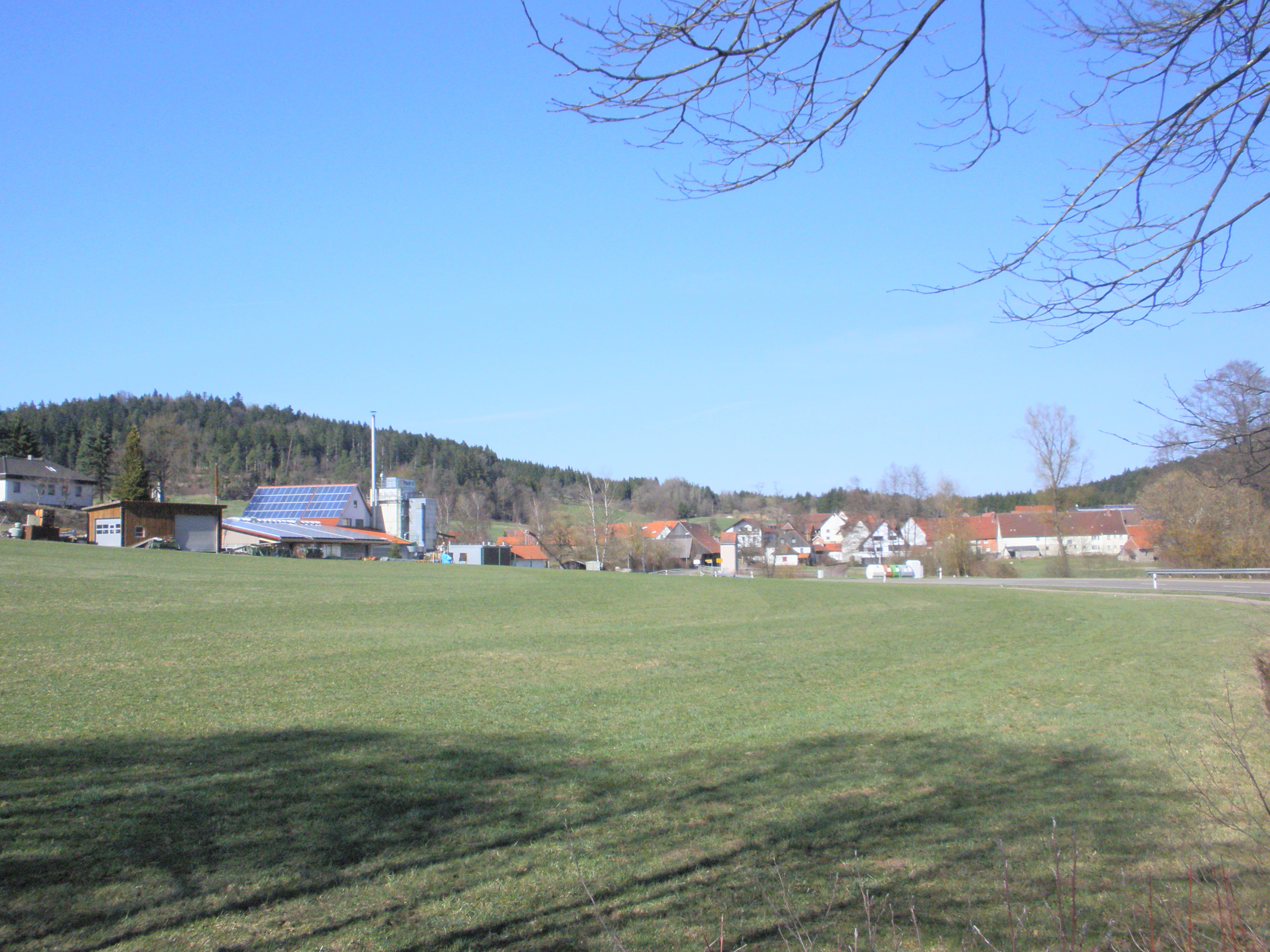
A wide, sunny meadow with green grass in the foreground, leading to a small rural settlement with various buildings and farm structures in the midground, backed by a forested hillside under a clear blue sky.
View of the Hoenig hamlet and the surrounding valley landscape within the Welzheimer Wald area.

Welzheimer Wald mit Leintal history and protected-area timeline

The Welzheimer Wald mit Leintal landscape protection area was established on 30 August 1972 by decree of the Regierungspräsidium Nordwürttemberg, the regional administrative authority of the former administrative district of Nordwürttemberg. The decree put the area under the category of Landschaftsschutzgebiet, a German landscape protection designation that aims to preserve the character and recreational value of larger landscape units rather than to enforce strict reserve status.

The early 1970s were a significant period for the systematization of nature protection in Baden-Württemberg, and the 1972 designation reflects that broader phase of formalized landscape conservation. By the time of designation, forests and valleys in the Welzheimer Wald and along the upper Lein already had a long informal relationship with the surrounding communities as sources of timber, grazing, and outdoor recreation. The 1972 order translated that relationship into a formal instrument of landscape protection, covering areas in both what is now the Rems-Murr-Kreis and the Ostalbkreis.

After the regional administrative reforms in Baden-Württemberg, the protection order was carried forward under successor administrative structures, and the area is now administered jointly by the Ostalbkreis and the Rems-Murr-Kreis. The protection area carries the LSG numbers 1.19.047 and 1.36.026, reflecting its split between the two districts, and is recorded in the World Database on Protected Areas under WDPA-ID 325761.

Welzheimer Wald mit Leintal landscape and geographic character

The landscape of the Welzheimer Wald mit Leintal is shaped by the gentle ridges and valleys typical of the Swabian Keuper uplands. Long, wooded ridges alternate with deeply incised valleys, creating a mosaic of forested high points and open valley floors drained by small streams flowing toward the Lein and other nearby river systems. The Leintal is a specific river valley running roughly east from the protected landscape toward the town of Heuchlingen and beyond.

Geologically, the area is dominated by Triassic Keuper formations belonging to the larger Schwäbisches Keuper-Lias-Land natural region. The Keuper substrate produces soils that are often moderately acidic and well suited to mixed forest, while differential erosion has produced the characteristic sequence of broad ridge tops and narrow valley floors. Two more specific natural sub-regions are represented within the protection area: the Schurwald and Welzheimer Wald in the western portion, and the Schwäbisch-Fränkische Waldberge in the eastern portion. The resulting landforms are low-mountain in scale, with elevations that rise and fall gradually rather than forming dramatic peaks.

The eastern part of the area, around Gschwend, Ruppertshofen, and the upper reaches of the Lein, has the more pronounced ridge-and-valley character of the Swabian-Franconian Forest hills, with tightly packed forests and modest valleys. The western part, closer to Welzheim and Alfdorf, opens into the broader forested uplands of the Welzheimer Wald itself. Together, the two halves of the area form a single, visually coherent protected landscape defined by its continuous forest cover and gentle topographic undulation.

Welzheimer Wald mit Leintal ecosystems, habitats, and plant life

The ecological identity of the Welzheimer Wald mit Leintal is that of a Keuper forest landscape, dominated by mixed deciduous and coniferous forest typical of the eastern Swabian uplands. The protection area encompasses both upland forests on the ridges and valley-side forests along the streams, producing a structurally diverse woodland mosaic with old-growth-like sections, managed timber forest, and natural regeneration areas.

The area's soils and geology, derived from Keuper sedimentary rocks, support the classic mixed forest communities of the Schwäbisch-Fränkische Waldberge and the Welzheimer Wald, including beech, oak, spruce, and related species typical of the region. Where the topography allows, small valley meadows, stream corridors, and forest edges add further habitat diversity. Because the protection purpose specifically targets an intact Keuper forest and valley landscape, the area is identified as one of the more representative unspoiled forest landscapes of this part of Baden-Württemberg.

Although the area is not a strict nature reserve, the landscape-level protection helps maintain ecological continuity across a significant area of the eastern Swabian uplands. Within the larger mosaic of Landschaftsschutzgebiete in both the Rems-Murr-Kreis and the Ostalbkreis, Welzheimer Wald mit Leintal functions as a connective core, tying together smaller protected valley and slope habitats to the east and west.

Welzheimer Wald mit Leintal wildlife and species highlights

The Welzheimer Wald mit Leintal supports the wildlife communities typical of extensive Keuper mixed forests in the eastern Swabian hill country. Large blocks of woodland and a relatively low level of intensive land use mean that the area acts as habitat for forest-associated mammal, bird, and invertebrate species typical of Swabian forest landscapes.

Common forest species include red deer, roe deer, and wild boar, which have long been part of the ecological character of the Welzheimer Wald and the adjacent Schwäbisch-Fränkische Waldberge. Birdlife in the area reflects the mixed forest structure, with woodland breeders and raptors that use both closed canopy and forest edge habitats. Stream corridors within the Lein valley and along smaller tributaries add riparian habitat elements that complement the broader forest matrix.

The explicit Schutzzweck of preserving an unspoiled Keuper forest and valley landscape underlines the area's wildlife value, even though detailed species inventories are not the focus of the protection designation. The area's role is less that of a single-species reserve and more that of a stable habitat backdrop for the broader forest fauna of the eastern Schwäbisch-Fränkische Waldberge.

Welzheimer Wald mit Leintal conservation status and protection priorities

The conservation profile of Welzheimer Wald mit Leintal is rooted in its designation as a Landschaftsschutzgebiet under the German federal and state nature-protection framework, corresponding to IUCN Category V (Protected Landscape/Seascape). This category is designed for larger areas of cultural and natural landscape where the goal is to maintain the overall character and ecological functioning of the landscape rather than to isolate a specific habitat or species.

The stated Schutzzweck emphasizes the preservation of an intact Keuper forest and valley landscape and recognizes the landscape's significance as a regional recreation resource. By protecting roughly 9,125 hectares of contiguous forest and valley across parts of two districts, the designation provides a durable legal basis against landscape-degrading developments such as large-scale forestry conversion, road-building, or settlement expansion.

In a regional conservation context, the protected landscape functions as a habitat core within the larger network of Landschaftsschutzgebiete in the Ostalbkreis and the Rems-Murr-Kreis. Its size and continuity are unusual for this category, and they give the area an outsized role in maintaining forest connectivity between the Schurwald and Welzheimer Wald natural region and the Schwäbisch-Fränkische Waldberge. The recognition by the World Database on Protected Areas, under WDPA-ID 325761, places the area in international registers of formally recognized protected landscapes.

Welzheimer Wald mit Leintal cultural meaning and human context

The Welzheimer Wald und Leintal lies within a region of long-standing rural and forestry traditions. The towns and villages around the protected area, including Welzheim, Alfdorf, Murrhardt, Schwäbisch Gmünd, and the smaller communities of the Ostalbkreis, have historical relationships with the surrounding forests as sources of timber, charcoal, and grazing, as well as places for traditional seasonal land use.

In the broader Swabian cultural geography, the Welzheimer Wald is part of the Schwäbischer Wald, a forested area with deep local identity. The protection designation from 1972 reflects a modern, formalized valuation of a landscape whose cultural and practical importance to the surrounding population had already been established for centuries. The protected landscape status today is one way in which that relationship is continued and given institutional form.

Top sights and standout views in Welzheimer Wald mit Leintal

Welzheimer Wald mit Leintal is a distinctive protected landscape in Baden-Württemberg that safeguards an unspoiled, large-scale Keuper forest and valley landscape in the eastern Swabian uplands. Its size, roughly 9,125 hectares across two districts, and its position bridging the Schurwald and Welzheimer Wald and the Schwäbisch-Fränkische Waldberge natural regions, give it unusually strong landscape connectivity.

Designated in 1972 under the Landschaftsschutzgebiet framework, the area combines a formal nature-protection role with explicit recognition of its value as a regional recreation landscape near population centers such as Schwäbisch Gmünd, Welzheim, and the Stuttgart region. It stands out as one of the more representative continuous forest landscapes of the eastern Swabian Keuper hill country.

Best time to visit Welzheimer Wald mit Leintal

The Welzheimer Wald mit Leintal is a forested low-mountain landscape whose character changes with the seasons in ways typical of Swabian forest country. Late spring and early summer are pleasant for hiking and nature observation, when forest paths are accessible, wildflowers in clearings and along streams reach peak display, and birdsong is most active. Autumn brings vivid forest color as the mixed deciduous canopy turns and the harvested or naturally fruiting elements of the forest become more visible.

Winter in the area is typically quiet, with snow possible at higher positions; in mild winters the forest remains readily walkable. Because the protection designation emphasizes the landscape's recreational function, the area is generally accessible year-round, though individual paths and viewpoints are more rewarding in daylight and fair weather. The protection area is close enough to larger population centers that short visits in any season are practical.

Monthly climate preview

Track long-term representative temperature ranges and monthly precipitation distributions

Welzheimer Wald mit Leintal Climate Normals and Annual Weather Patterns

Historical data points for Welzheimer Wald mit Leintal reveal a measured annual temperature rhythm spanning from sub-zero winter minimums to warm summer maximums alongside steady daily precipitation averages. Consulting the complete monthly profile provides deeper analytical depth for understanding long-term regional climate conditions at this sampled elevation.
Annual mean9 °C
0 °C20 °C
Jan
Feb
Mar
Apr
May13°
Jun17°
Jul20°
Aug20°
Sep15°
Oct10°
Nov
Dec
Warmest month
July

19.6 °C

Coolest month
January

-0.2 °C

Wettest month
July

2.7 mm/day

Driest month
April

1.6 mm/day

Park location guide

Geography guide, regional context, and park location map for Welzheimer Wald mit Leintal

Welzheimer Wald mit Leintal park geography, regions, and map view in Germany

Understand where Welzheimer Wald mit Leintal sits in Germany through a broader geographic reading of the surrounding landscape, nearby location context, and its mapped position within the national park landscape.

How Welzheimer Wald mit Leintal fits into Germany

Germany is a federal republic in Western and Central Europe with a population of over 83 million across sixteen constituent states. It is Europe's largest economy by nominal GDP and a major global exporter and importer. The capital is Berlin, and the country borders Denmark, Poland, Czech Republic, Austria, Switzerland, France, Luxembourg, Belgium, and the Netherlands.

Wider geography shaping Welzheimer Wald mit Leintal in Germany

Germany is located in Western and Central Europe, spanning 357,022 km². It borders Denmark to the north, Poland and the Czech Republic to the east, Austria and Switzerland to the south, and France, Luxembourg, Belgium, and the Netherlands to the west. The country has coastlines on the Baltic Sea and North Sea to the north, with the Alps located in the southern region.

Map view of Welzheimer Wald mit Leintal

Use this park location map to pinpoint Welzheimer Wald mit Leintal in Germany, understand its exact geographic position, and read its mapped placement within the surrounding landscape more clearly.

Pigeon | © OpenStreetMap contributors

Location context for Welzheimer Wald mit Leintal

Baden-WürttembergOstalbkreisRems-Murr-Kreis

Visualizing the ridge and valley terrain of the Swabian Keuper uplands

Welzheimer Wald mit Leintal Photos, Scenery, and Protected Forest Landscapes

Visual documentation reveals the continuous mixed forests and incised river valleys defining Welzheimer Wald mit Leintal. Photographic records provide clear insight into the protected upland terrain and low mountain character of southwestern Germany.

A wide, sunny meadow with green grass in the foreground, leading to a small rural settlement with various buildings and farm structures in the midground, backed by a forested hillside under a clear blue sky.

Park atlas

Compare surrounding regional park geography and connected Keuper forest reserves in southwestern Germany

Parks Near Welzheimer Wald mit Leintal and Related Protected Landscapes in Baden-Württemberg

Browse other protected areas and forested upland reserves situated near Welzheimer Wald mit Leintal across the eastern Swabian hills. Extending the regional park comparison helps map broader conservation landscapes and connected river valleys throughout Baden-Württemberg.
Protected landscapeBaden-Württemberg
About 9.7 km away#1 closest

Northwest

Landschaftsschutzgebiet Murrhardter Wald: Protected Landscape and Regional Geography

Keuper forest formations in the Rems-Murr-Kreis region

Spanning over 2,000 hectares across multiple municipal territories, the Landschaftsschutzgebiet Murrhardter Wald protects an intact forest and valley system in the eastern Swabian hill country. The mapped geography highlights a complex interplay of forested heights and narrow valley cuts, serving as a critical example of protected countryside land use in southwestern Germany.

Area
23.403 km²
Established
1971
IUCN
V
Relief
Upland
Protected landscapeBaden-Württemberg
About 14 km away#2 closest

Northwest

Franzosenbuckel Protected Landscape: An Atlas Guide to the Murr Valley Terrain

A prominent hill formation within the Baden-Württemberg regional geography.

Franzosenbuckel is a protected landscape in Murrhardt, Germany, recognized for its elevation rising sharply from the Murr river valley. This compact site preserves a mix of wooded and open orchard terrain that holds historical and ecological significance within the regional landscape of southwestern Germany.

Area
0.017 km²
Established
1971
IUCN
V
A horizontal watercolor painting showing soft, rounded green hills and a treeline against a pale background.
Protected landscapeBaden-Württemberg
About 16 km away#3 closest

Southwest

Ottilienberg Protected Landscape: Geomorphological Identity and Regional Mapping

A distinct Keuper outlier hill within Baden-Württemberg

The Ottilienberg protected landscape is a landmark Keuper Zeugenberg situated on the southern outskirts of Schorndorf. This compact area features a striking oak-dominated woodland crest and traditional orchard meadows, serving as a key example of a preserved cultural-historic landscape in southwestern Germany.

Area
0.083 km²
Established
1968
IUCN
V
Relief
Upland
Faint watercolor illustration of rolling green hills and a pinkish foreground against a white background.
Protected areaBaden-Württemberg
About 19 km away#4 closest

Southeast

Albtrauf Donzdorf-Heubach: Protected Escarpments and Karst Terrain in the Swabian Alb

Natura 2000 protected area in eastern Baden-Württemberg

The Albtrauf Donzdorf-Heubach site comprises eight protected parcels along the Swabian Alb. Its geography is defined by steep limestone cliffs, dissected valleys, and extensive karst systems that support specialized biodiversity. This protected landscape highlights the complex interaction between Upper Jurassic geological formations and traditional land-use patterns across the Göppingen and Ostalbkreis districts.

Area
25.333 km²
Established
2019
Relief
Highland
Climate
Temperate
Protected landscapeBaden-Württemberg
About 19 km away#5 closest

West

Zipfelbachtal, Korber Kopf, Buocher Höhe, Remstalhänge, Ramsbachtal und Grafenberg Protected Landscape Map

Mapping the Keuper cultural landscape of Baden-Württemberg

Study the intricate topography and land use patterns of this expansive protected area in the Rems-Murr-Kreis. The region preserves a variety of habitats, including vineyard slopes, traditional Streuobst orchards, and forested ravines, providing a clear window into the natural and agricultural heritage of the eastern Stuttgart region.

Area
20.856 km²
Established
1968
IUCN
V
Relief
Upland
A watercolor painting showing a soft green landscape with rolling hills, a distant mountain range, and flowering trees.
Protected landscapeBaden-Württemberg
About 19 km away#6 closest

Southwest

Nassachtal Protected Landscape: Geographic Overview and Mapped Terrain in Baden-Württemberg

Conservation geography of the Nassach stream catchment area.

Covering the full extent of the Nassach valley in southwestern Germany, this protected landscape serves as a critical ecological link between forest and agricultural zones. The terrain encompasses a typical Swabian hill country profile with incised stream valleys and wooded ridges, securing natural continuity across the Schurwald and Welzheimer Wald regions.

Area
21.666 km²
Established
1982
IUCN
V
Relief
Upland
A soft watercolor painting of a river valley with green fields, distant hills, and a prominent tree in the foreground on the right.
Protected areaBaden-Württemberg
About 24 km away#7 closest

Northeast

Bühlertal Vellberg-Geislingen: Protected River Valley and Karst Geography

A concentrated habitat corridor in Baden-Württemberg

This protected area follows the Bühler river through a series of tight meanders and dramatic limestone formations. The landscape is characterized by a transition from wet floodplain woods and tall-herb fringes to dry calcareous grasslands and hillside forests. Covering over 800 hectares, the site serves as a vital ecological link across the Kocher-Jagst plains and the forested ridges of the Schwäbisch-Fränkische Waldberge.

Area
8.474 km²
Established
2019
Relief
Upland
Climate
Temperate
Protected landscapeBaden-Württemberg
About 26 km away#8 closest

South

Wolfschlugen Protected Landscape: Geography and Atlas of the Filder Plateau

Mapped protected lands in Baden-Württemberg Germany

Wolfschlugen stands as a significant protected area in the Esslingen district, preserving traditional orchard meadows and open agricultural plains. The area offers a detailed study of regional land use, featuring a mosaic of meadow habitats and stream-side wetlands essential to the Filder plateau landscape character.

Area
0.51 km²
Established
1985
IUCN
V

Common questions about visiting, size, designation, and location context for Welzheimer Wald mit Leintal

Welzheimer Wald mit Leintal FAQs for park facts, access, geography, and protected area context

Find quick answers about Welzheimer Wald mit Leintal, including protected-area facts, park geography, trail and visitor context, and how the park fits into its surrounding country and regional landscape.
MoriAtlas Explorer

Continue Your Protected Areas Search Across the Global Atlas

Deepen your exploration by continuing the structured search for national parks and protected areas worldwide. Utilize the comprehensive filtering capabilities to compare different conservation landscapes and refine your understanding of global park geography. Discover more about the distribution and characteristics of protected natural areas.

Global natural geography