
Mori Atlas logo
Protected landscapeWendlingen am Neckar

A managed Swabian countryside mosaic of meadow habitats, orchard plains, and woodland corridors

Wendlingen am Neckar Protected Landscape: Geography and Regional Ecological Mapping

(Landschaftsschutzgebiet "Wendlingen am Neckar")

Wendlingen am Neckar functions as a crucial protected landscape near the Filder plateau, covering six distinct parcels of ecologically significant land in Baden-Württemberg. This area provides a rare, well-structured habitat network amidst dense urban expansion, preserving traditional orchard meadows, hedgerows, and brookside corridors that define the regional Swabian character. Through careful land management, these interconnected zones maintain essential ecological balance, biodiversity refuges, and natural recreation space within the district of Esslingen.

landscape protection areaLandschaftsschutzgebietorchard meadowsStreuobstwiesenmeadowshedgerows
A vibrant illustration of a dramatic mountain valley with a large granite cliff, a central waterfall flowing into a river, evergreen trees, and blooming pink and white trees in the foreground.

Wendlingen am Neckar

Protected landscape

Park overview

Structured park overview, official facts, and landscape profile for Wendlingen am Neckar Landscape Protection Area

Wendlingen am Neckar Landscape Protection Area park facts, protected area profile, and essential visitor context

Review the core facts for Wendlingen am Neckar Landscape Protection Area, including designation, size, terrain, visitor scale, habitats, and operating context in one park-focused overview.

About Wendlingen am Neckar Landscape Protection Area

Wendlingen am Neckar is one of many small landscape protection areas (Landschaftsschutzgebiete) in the district of Esslingen in Baden-Württemberg, and is characteristic of the German approach of safeguarding traditional countryside around and between settled areas. The protected area consists of six separate parcels, together covering roughly 227 hectares, and lies to the north and east of the town of Wendlingen am Neckar, in the transition between the Albvorland foothills and the Filder plateau.

Unlike large wilderness parks or national parks, this area is a working, inhabited landscape. Its core features are typical of the Schwäbische Alb foothills and Filder region: dry and mesic meadows, traditional orchard meadows with scattered fruit trees, hedgerows that divide fields, small patches of woodland along brooks and field edges, and the brooks themselves. These features form a habitat mosaic that supports a rich community of insects, birds, small mammals, and plants, including species of conservation concern.

The protected area's significance is partly ecological and partly cultural. It preserves a centuries-old pattern of land use that has shaped the visual identity of the Wendlingen countryside. The protection ordinance explicitly aims to keep this landscape intact amid the pressures of suburban expansion, roads, and intensive agriculture in the greater Stuttgart region. By safeguarding these elements, the area also functions as a recreational landscape close to where people live.

Administered by the Landratsamt Esslingen and classified as an IUCN Category V protected landscape, Wendlingen am Neckar stands as a representative example of how small, regionally important landscape protection areas contribute to biodiversity conservation, landscape identity, and quality of life in densely settled parts of southern Germany.

Quick facts and research context for Wendlingen am Neckar Landscape Protection Area

Wendlingen am Neckar is a state-recognized landscape protection area (Landschaftsschutzgebiet) with the official designation number 1.16.084 and a World Database on Protected Areas entry (WDPA 325762). It is classified under IUCN Category V (Protected Landscape/Seascape) and is administered by the Landratsamt Esslingen.

The protected area consists of six component parcels and covers approximately 227 hectares north and east of the town of Wendlingen am Neckar. It belongs to the natural regions of the Mittleres Albvorland and the Filder within the larger Schwäbisches Keuper-Lias-Land natural unit, and was designated by ordinance on 25 November 1992.

Protection and recognition

Examine documented conservation parameters, statutory designations, and global database identifiers.

Wendlingen am Neckar Protection Status and International Recognition Data

Protected area records for Wendlingen am Neckar compile verified administrative frameworks, official designation metrics, and conservation status indicators. Database entries provide structured access to recorded international recognition sources and geographic identifiers without speculative management claims.

Protection details

WDPA ID
325762
Park context

Deeper park guide and search-rich context for Wendlingen am Neckar Landscape Protection Area

Wendlingen am Neckar Landscape Protection Area history, landscape, wildlife, and travel context

Explore Wendlingen am Neckar Landscape Protection Area through its history, landscape character, ecosystems, wildlife, conservation priorities, cultural context, and seasonal travel timing in a structured park guide built for atlas discovery and search intent.

Why Wendlingen am Neckar Landscape Protection Area stands out

The protected area is best known for its traditional, structurally diverse agricultural landscape: species-rich meadows, orchard meadows (Streuobstwiesen), hedgerows, field and brookside woodland (Feld- und Bachgehölze), and the small streams that run through the parcels. Together, these elements form a connected mosaic of habitats that is unusual in a district otherwise dominated by dense settlement and intensive farming. It is also recognized for its strong local ecological function despite its modest size. By maintaining landscape connectivity and protecting threatened species habitats at the margin of the Wendlingen urban area, the area serves as both a refuge for biodiversity and a nearby green recreation space for the local population.
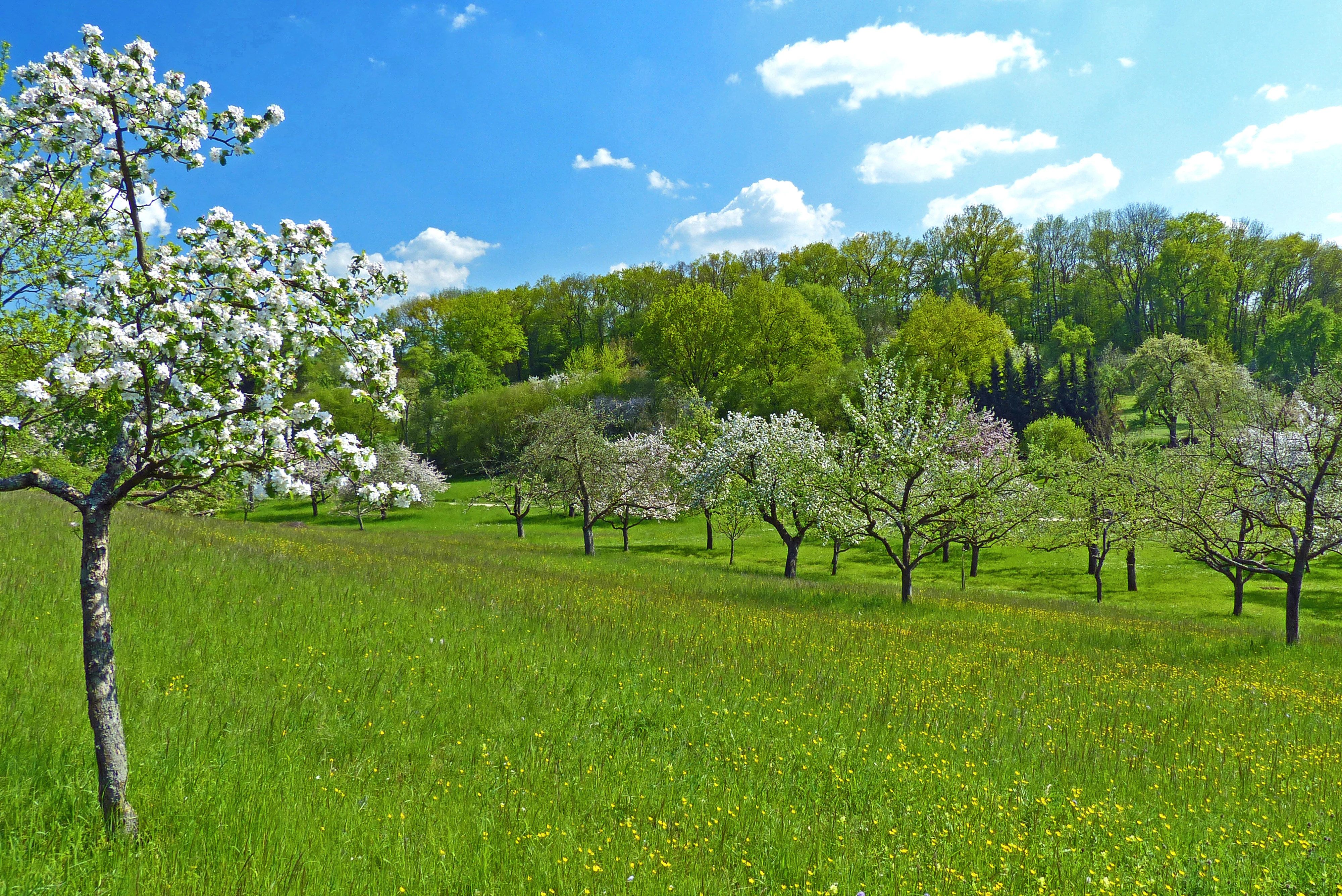
A wide view of a sloping green meadow filled with blooming fruit trees under a bright blue sky with scattered clouds.
Orchard meadows in bloom at the Wendlingen am Neckar landscape protection area in spring.

Wendlingen am Neckar Landscape Protection Area history and protected-area timeline

The present-day Wendlingen am Neckar landscape protection area was formally established by ordinance of the Landratsamt Esslingen on 25 November 1992. The 1992 ordinance replaced, in the areas it covered, an older protection regime: the 1942 ordinance issued by the former Landratsamt Nürtingen for the protection of landscape parts and landscape elements within the Nürtingen district.

This legal continuity shows that the contemporary protected area is not the result of a sudden decision but rather the continuation and updating of a much longer tradition of landscape protection in the region. The new ordinance consolidated the fragmented patchwork around Wendlingen into a coherent, modern framework better suited to current planning, conservation, and recreation needs.

Since its designation, the area has been managed under the supervision of the Landratsamt Esslingen and is part of the broader system of landscape protection areas in the district. It is recorded in the official Schutzgebietsverzeichnis of the Landesanstalt für Umwelt Baden-Württemberg and in the international World Database on Protected Areas under the ID 325762.

Wendlingen am Neckar Landscape Protection Area landscape and geographic character

The landscape of the Wendlingen am Neckar protected area is shaped by the transition between the foothills of the Schwäbische Alb and the Filder plateau, both belonging to the broader Schwäbisches Keuper-Lias-Land natural region. Topographically, it is gently rolling terrain, with shallow valleys cut by small brooks and occasional rises that frame views across the surrounding countryside.

The visually defining elements are agricultural and semi-natural rather than wild. Open meadows of various types, including flower-rich meadows typical of the region, alternate with traditional orchard meadows where widely spaced fruit trees give the landscape its characteristic park-like appearance. Hedgerows form green lines between fields, while narrow strips of field-edge woodland (Feldgehölze) and brook-side woodland (Bachgehölze) follow the small watercourses. These brooks themselves are integral to the landscape, providing both habitat and visual structure.

Together, these elements produce the classic, finely textured Swabian countryside mosaic that is increasingly rare in the densely settled greater Stuttgart area. The protected area thus reads as a network of small, interconnected landscape chambers rather than a single continuous block of land.

Wendlingen am Neckar Landscape Protection Area ecosystems, habitats, and plant life

Ecologically, the Wendlingen am Neckar protected area is best understood as a habitat mosaic rather than a single ecosystem type. The mix of meadows, orchard meadows, hedgerows, woodland strips, and brooks creates multiple microhabitats within a relatively small area, supporting a high diversity of species relative to its size.

The meadows contribute grassland flora and associated insect communities, including pollinators that depend on the structured countryside. Orchard meadows are particularly valuable because mature fruit trees, dead wood, and undergrowth provide nesting sites, food resources, and shelter for a wide range of birds, insects, and small mammals. Hedgerows act as corridors, connecting otherwise isolated habitat patches and allowing species to move across the agricultural matrix.

The brooks and their wooded banks add a wetter, shaded component that contrasts with the open meadows. They support riparian plant communities, amphibians, and aquatic invertebrates, and serve as ecological stepping stones between larger river and stream systems in the region. The combination of dry, mesic, and wet habitats within a compact area is a major reason the area is considered to have high ecological value.

Wendlingen am Neckar Landscape Protection Area wildlife and species highlights

Because the sources describe the protected area at the habitat and species-group level rather than naming individual species in detail, the wildlife profile is best summarized at the level of ecological function. The protected area's meadows, orchard meadows, hedgerows, and brookside woodlands collectively support a diverse community of insects, birds, and small mammals, including species that are considered threatened or in decline at the regional level.

Orchard meadows in particular are known across southern Germany as important habitats for orchard-dependent birds, bats, and insects, and the Wendlingen am Neckar landscape area is no exception. Hedgerows and brookside woodlands function as movement corridors and refuges for species that cannot survive in intensive farmland or fully built-up areas. The protection ordinance explicitly notes that the area serves as an important habitat and retreat zone for many, partly endangered animal and plant species.

The protected area's small size means that its value for wildlife depends heavily on its connection to the wider landscape, including the surrounding agricultural land, the Neckar valley, and other protected areas in the district. In this sense, the Wendlingen am Neckar protected area functions less as an isolated wildlife reserve and more as a key node in a regional habitat network.

Wendlingen am Neckar Landscape Protection Area conservation status and protection priorities

The conservation significance of Wendlingen am Neckar lies in its role as a local stronghold of traditional countryside amid a heavily modified regional landscape. The protection ordinance highlights that the area's meadows, orchard meadows, hedgerows, field and brookside woodlands, and streams form landscape elements of high ecological value, and that they serve as important habitats and retreat zones for many, partly threatened species of flora and fauna.

The protection also has an explicit landscape-ecological justification. In a town such as Wendlingen, where most of the municipal area is shaped by settlement or intensive agriculture, these smaller natural and semi-natural elements are described in the ordinance as being of outstanding importance for the performance of the natural balance (Naturhaushalt). They regulate local microclimate, support nutrient and water cycles, and connect otherwise fragmented habitats.

Beyond ecology, the ordinance addresses conservation of landscape character. It aims to prevent further construction of small buildings and enclosures that would visually fragment the landscape, and to maintain a green separation (Grünzäsur) between the Wendlingen and Bodelshofen districts. This combination of biodiversity, ecosystem-function, and landscape-identity objectives is typical of German Landschaftsschutzgebiete and of IUCN Category V protected landscapes more broadly.

Wendlingen am Neckar Landscape Protection Area cultural meaning and human context

Wendlingen am Neckar's cultural context is closely tied to the historical land use of the Swabian foothills and the Filder plateau. The protected area preserves elements of a centuries-old agricultural landscape, especially orchard meadows (Streuobstwiesen), which are an iconic feature of the region and form part of the cultural identity of rural Baden-Württemberg.

Orchard meadows, hedgerows, and small field-edge woodlands are not only ecological features but also cultural ones. They reflect traditional forms of land management that combined fruit production, haymaking, and livestock grazing, and they continue to shape the visual identity of the landscape around Wendlingen. By protecting these elements, the area also protects an aspect of regional heritage that has elsewhere been lost to intensification or redevelopment.

At the same time, the protected area serves as a nearby place for nature-oriented recreation for residents of Wendlingen and surrounding communities, blending its ecological role with a quiet, everyday cultural function for the local population.

Top sights and standout views in Wendlingen am Neckar Landscape Protection Area

The Wendlingen am Neckar protected area stands out as a compact, well-structured example of a Swabian countryside mosaic, combining meadows, orchard meadows, hedgerows, and brookside woodland into a coherent ecological and visual unit.

Its establishment in 1992, building on earlier 1942 protection measures, gives it a clear legal and administrative continuity, while its IUCN Category V status places it within the international framework of protected landscapes. Its proximity to the town and its explicit role as both a species refuge and a local recreation area make it a particularly relevant example of how small landscape protection areas function in densely settled parts of southern Germany.

Best time to visit Wendlingen am Neckar Landscape Protection Area

Because the protected area is a traditional agricultural and orchard landscape rather than a high-mountain or remote-wilderness setting, its appeal varies gently with the seasons rather than dramatically. Late spring and early summer are particularly attractive, when the meadows come into flower and orchard meadows are in full bloom, offering strong pollinator and bird activity.

Late summer and early autumn bring fruit harvest in the orchards and richer colors in hedgerows and field edges, while autumn light makes the patchwork of meadows and woodlands especially photogenic. Winter visits are quieter, with bare orchard trees revealing the underlying field and hedgerow structure of the landscape. Visitors should note that this is a working, inhabited protected landscape with no defined visitor infrastructure, so timing should be chosen for personal comfort and appreciation of seasonal landscape character rather than for peak events.

Monthly climate preview

Long-term representative point measurements tracking monthly temperature and precipitation variation

Wendlingen am Neckar Climate Normals, Annual Temperature and Precipitation Rhythm

Representative coordinate records show average monthly temperatures ranging from sub-zero winter minimums to warm summer highs alongside steady precipitation rates throughout the year. Reviewing the complete twelve-month statistical profile clarifies long-term thermal rhythms and moisture patterns across the protected terrain.
Annual mean8 °C
-1 °C18 °C
Jan-1°
Feb
Mar
Apr
May13°
Jun16°
Jul18°
Aug18°
Sep14°
Oct
Nov
Dec
Warmest month
July

18.2 °C

Coolest month
January

-1.1 °C

Wettest month
July

3.2 mm/day

Driest month
February

1.7 mm/day

Park location guide

Geography guide, regional context, and park location map for Wendlingen am Neckar Landscape Protection Area

Wendlingen am Neckar Landscape Protection Area park geography, regions, and map view in Germany

Understand where Wendlingen am Neckar Landscape Protection Area sits in Germany through a broader geographic reading of the surrounding landscape, nearby location context, and its mapped position within the national park landscape.

How Wendlingen am Neckar Landscape Protection Area fits into Germany

Germany is a federal republic in Western and Central Europe with a population of over 83 million across sixteen constituent states. It is Europe's largest economy by nominal GDP and a major global exporter and importer. The capital is Berlin, and the country borders Denmark, Poland, Czech Republic, Austria, Switzerland, France, Luxembourg, Belgium, and the Netherlands.

Wider geography shaping Wendlingen am Neckar Landscape Protection Area in Germany

Germany is located in Western and Central Europe, spanning 357,022 km². It borders Denmark to the north, Poland and the Czech Republic to the east, Austria and Switzerland to the south, and France, Luxembourg, Belgium, and the Netherlands to the west. The country has coastlines on the Baltic Sea and North Sea to the north, with the Alps located in the southern region.

Map view of Wendlingen am Neckar Landscape Protection Area

Use this park location map to pinpoint Wendlingen am Neckar Landscape Protection Area in Germany, understand its exact geographic position, and read its mapped placement within the surrounding landscape more clearly.

Pigeon | © OpenStreetMap contributors

Location context for Wendlingen am Neckar Landscape Protection Area

Baden-Württemberg

Visualizing the meadows, orchards, and terrain of southern Germany

Wendlingen am Neckar Photos and Protected Landscape Scenery

Photographic records document the rolling terrain, traditional orchard meadows, and hedgerow networks defining the protected landscape. Visual exploration reveals the ecological mosaic and local habitat corridors sustaining the protected area.

A wide view of a sloping green meadow filled with blooming fruit trees under a bright blue sky with scattered clouds.

Park atlas

Compare regional landscapes, orchard meadows, and nearby nature reserves

Explore Protected Areas and Parks Near Wendlingen am Neckar

Browse other protected areas and regional parks located near Wendlingen am Neckar to examine similar landscape mosaics. Comparing adjacent protected terrain reveals broader ecological patterns across the surrounding Swabian countryside.
Protected landscapeLandkreis Esslingen
About 4.5 km away#1 closest

North

Wernau (Neckar) Protected Landscape: Geographic Overview and Mapped Cultural Terrain

Landscape protection area within the Landkreis Esslingen region

Trace the boundaries of the Wernau (Neckar) protected landscape, an ecologically significant mosaic of meadow orchards, riparian vegetation, and small woodlands. Situated in the Landkreis Esslingen of Baden-Württemberg, this area functions as a critical buffer zone that maintains the continuity of local habitats between the Filder plain and the Swabian Alb foothills.

Area
2.27 km²
Established
1995
IUCN
V
Protected landscapeBaden-Württemberg
About 5.4 km away#2 closest

Northwest

Unteres Körschtal Protected Landscape: Geography and Mapped Boundaries in Baden-Württemberg

An ecological green corridor within the Swabian Keuper-Lias landscape

Unteres Körschtal protects the natural valley floor and adjacent slopes of the lower Körsch river. This landscape conservation area provides essential habitat and recreational space between the Filder plateau and the Neckar valley, standing as a primary example of regional geography in Germany.

Area
4.729 km²
Established
1978
IUCN
V
Protected landscapeBaden-Württemberg
About 7.1 km away#3 closest

South

Tiefenbachtal Protected Landscape: Geographic Boundaries and Regional Terrain Map

Swabian Alb foothill mosaic in the Esslingen district

Investigate the protected landscape of Tiefenbachtal, where gently rolling terrain and stream-cut valleys form a continuous ecological corridor. This record covers the physical geography, meadow and woodland composition, and the broader context of this site within the Baden-Württemberg pre-Alb landscape.

Area
0.35 km²
Established
1958
IUCN
V
Relief
Upland
Protected landscapeBaden-Württemberg
About 7.4 km away#4 closest

East

Notzingen Protected Landscape: Mapping the Voralb Foothills and Swabian Alb Terrain

Regional protected area analysis in Landkreis Esslingen

Notzingen represents a coherent protected landscape composed of three parcels near the Swabian Alb foothills. The area is defined by a delicate intersection of stream-side riparian habitats and traditional Streuobstwiesen orchard meadows. This atlas-focused entry provides spatial context for understanding how these protected lands maintain the character of the southern German countryside.

Area
3.15 km²
Established
1989
IUCN
V
Relief
Upland
A pale watercolor landscape illustration showing rolling green hills and meadows under a soft yellow sky.
Protected landscapeBaden-Württemberg
About 8.8 km away#5 closest

South

Owen Protected Landscape: A Geographic Analysis of Orchard Meadows and Teckberg Terrain

Baden-Württemberg protected area and regional landscape map

Examine the detailed landscape composition of the Owen protected area, a vital reserve in the Mittleres Albvorland. This atlas entry focuses on the interaction between traditional orchard meadow mosaics, hedgerows, and the abrupt topographical shift toward the Teckberg peak, providing a clear geographic context for this protected natural region.

Area
5.67 km²
Established
1974
IUCN
V
A minimalist watercolor painting depicting a soft-focus landscape with rolling hills, distant ridgelines, and scattered trees across a meadow, rendered in muted greens, purples, and pinks on a white background.
Protected landscapeBaden-Württemberg
About 11 km away#6 closest

East

Ohmden-Holzmaden Protected Landscape: Swabian Alb Foothill Mapping

A diverse mosaic of traditional orchards and stream valleys

Ohmden-Holzmaden encompasses a vital protected landscape in the Esslingen district, defined by the Trinkbach, Seebach, and Aubach valleys. This geography of traditional orchards, meadows, and hedgerows maintains an open, structured rural habitat that serves as a critical refuge within the broader Swabian Alb foothill region of Germany.

Area
3.111 km²
Established
1993
IUCN
V
Relief
Upland
Protected landscapeBaden-Württemberg
About 12 km away#7 closest

South

Neuffen auf Gemarkungen Neuffen und Kappishäusern Protected Area and Regional Landscape

Geography of the Swabian Alb escarpment and riparian zones

This protected landscape defines the visual and ecological character of the area surrounding the Hohenneuffen and Jusi hills. The terrain spans limestone slopes, fruit-bearing orchards, and the Steinach river valley. By integrating local habitat protection with regional biosphere networks, the region serves as a vital transition point between the plateau and the Neckar basin.

Area
13.41 km²
Established
1993
IUCN
V
Relief
Mountain
Protected landscapeBaden-Württemberg
About 14 km away#8 closest

Southeast

Weilheim an der Teck auf Gemarkungen Weilheim und Hepsisau Protected Landscape Atlas

Volcanic hill geography in the Baden-Württemberg region

This protected area safeguards a richly structured landscape where rolling foothills meet the steep escarpments of the Swabian Alb. Centered on the volcanic peaks of Limburg and Egelsberg, the region maintains a vital balance between forest corridors and open agricultural plains within the district of Esslingen.

Area
13.615 km²
Established
1979
IUCN
V

Common questions about visiting, size, designation, and location context for Wendlingen am Neckar Landscape Protection Area

Wendlingen am Neckar Landscape Protection Area FAQs for park facts, access, geography, and protected area context

Find quick answers about Wendlingen am Neckar Landscape Protection Area, including protected-area facts, park geography, trail and visitor context, and how the park fits into its surrounding country and regional landscape.
MoriAtlas Explorer

Continue Your Protected Areas Search Across the Global Atlas

Deepen your exploration by continuing the structured search for national parks and protected areas worldwide. Utilize the comprehensive filtering capabilities to compare different conservation landscapes and refine your understanding of global park geography. Discover more about the distribution and characteristics of protected natural areas.

Global natural geography