Mori Atlas logo
Nature reserveWeseraue

A vital wetland corridor and waterbird sanctuary spanning the middle Weser river valley

Weseraue Nature Reserve: Mapped Protected Landscapes and Weser River Floodplain Geography

(EU-Vogelschutzgebiet Weseraue)

Weseraue represents a significant 27 square kilometer protected landscape along the Weser river in the Minden-Lübbecke district of North Rhine-Westphalia. The area features a complex mosaic of free-flowing river sections, oxbows, marshlands, and floodplain meadows that function as an essential staging and wintering ground for migratory waterbirds and waders. This mapped terrain showcases the interplay between traditional agricultural land use and dynamic river ecosystems.

bird protection areaSPANatura 2000river floodplainWeser riverwetlands

Weseraue

Nature reserve

Park overview

Structured park overview, official facts, and landscape profile for Weseraue Bird Protection Area

Weseraue Bird Protection Area park facts, protected area profile, and essential visitor context

Review the core facts for Weseraue Bird Protection Area, including designation, size, terrain, visitor scale, habitats, and operating context in one park-focused overview.

About Weseraue Bird Protection Area

Weseraue is a floodplain-scale bird protection area centered on a long stretch of the Weser river in the Minden-Lübbecke district of eastern Westphalia. Designated in 1983 and managed under the European Union Birds Directive, it is one of the cornerstone conservation sites for aquatic and wetland-dependent birdlife in North Rhine-Westphalia, protecting around 27 square kilometers of riverine marshland, wet meadows, reedbeds, arable land, and small woodland fragments.

Geographically, the area follows the Weser from the southern edge of Petershagen north to the Lower Saxony border near Schlüsselburg, encompassing the Lahder Marsch and two separated sub-areas. About six kilometers of the river within the site are impounded, while the remainder flows more naturally, producing a varied mosaic of slow-moving and free-flowing reaches. This hydrological diversity, combined with adjacent wet grassland, marsh, and farmland, supports an unusually high density and seasonal turnover of bird species.

The site is administered by the Regierungspräsidium Detmold and reported within the Natura 2000 network under code DE3519401. It overlaps with the Naturschutzgebiet Weseraue, the Staustufe Schlüsselburg reserve, the Windheimer Marsch, the Häverner Marsch, and the Grube Baltus quarry area, together forming a coherent ecological corridor along the middle Weser. In regional conservation policy, Weseraue is repeatedly described as one of the most significant breeding, moulting, staging, migration, and wintering areas in the state, particularly for waterbirds and waders, and functions as a critical refuge during severe winters when many smaller waterbodies freeze over.

Quick facts and research context for Weseraue Bird Protection Area

Weseraue is an EU Bird Protection Area (SPA), identification code DE-3519-401, designated in 1983 under the European Birds Directive. It lies in the Kreis Minden-Lübbecke in North Rhine-Westphalia, Germany, and is administered by the Regierungspräsidium Detmold. The site covers approximately 27 square kilometers and extends about 25 kilometers along the Weser river, including the Lahder Marsch and two distinct sub-areas. It forms part of the Natura 2000 network and overlaps with several nature reserves along the middle Weser floodplain.

Protection and recognition

Documented terrestrial protection framework and Natura 2000 recognition details

Weseraue Protection Status and International Recognition Data

Weseraue holds documented terrestrial protection status supported by formal Natura 2000 recognition records. Conservation researchers review these verified administrative frameworks and designation sources to understand official protected area governance.

International recognition

Protection details

Protection scope
Terrestrial
WDPA ID
555537439
Park context

Deeper park guide and search-rich context for Weseraue Bird Protection Area

Weseraue Bird Protection Area history, landscape, wildlife, and travel context

Explore Weseraue Bird Protection Area through its history, landscape character, ecosystems, wildlife, conservation priorities, cultural context, and seasonal travel timing in a structured park guide built for atlas discovery and search intent.

Why Weseraue Bird Protection Area stands out

Weseraue is best known for its role as one of the foremost waterbird and wader sanctuaries in North Rhine-Westphalia. The floodplain serves as the state's most important wintering area for Common Merganser and Common Goldeneye, and is a key staging site for European Golden Plover, with the Weser itself often providing a last open-water refuge for ducks, mergansers, and divers during harsh frosts. Its combination of dynamic river floodplains, marshlands, meadows, and agricultural land supports an unusually rich seasonal birdlife, including White Stork, Bewick's Swan, Whooper Swan, Bean Goose, Marsh Harrier, Eurasian Bittern, Black-tailed Godwit, Ruff, Common Snipe, Curlew, and a wide range of breeding and passage waterfowl, waders, and riparian songbirds.
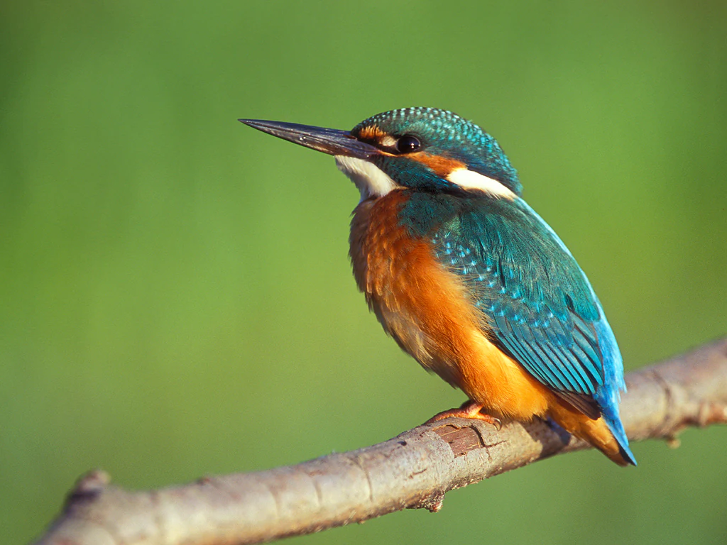
A common kingfisher bird with vibrant blue and orange plumage, perched on a thin brown branch against a soft green out of focus background.
A common kingfisher perched on a branch in the Weseraue nature reserve.

Weseraue Bird Protection Area history and protected-area timeline

Weseraue was designated as an EU Bird Protection Area under the European Birds Directive in 1983, making it one of the earlier formally protected floodplain sites of its kind in North Rhine-Westphalia. Its establishment reflected growing European recognition of the Weser floodplain's exceptional value for breeding, migrating, and wintering waterbirds, and aligned with broader efforts to build a coherent network of protected riverine and wetland habitats across the EU.

Over time, the boundaries of the SPA have been aligned with overlapping national-level conservation instruments, including the Naturschutzgebiet Weseraue, the Schlüsselburg weir nature reserve, and several adjacent marshland and former-extraction sites such as the Windheimer Marsch, Häverner Marsch, and Grube Baltus. This layering of protection has reinforced the site's role as a long-term refuge for sensitive bird species and has integrated it formally into the Natura 2000 ecological network, where it is recorded under the unified code DE3519401.

Weseraue Bird Protection Area landscape and geographic character

The Weseraue landscape is defined by the floodplain of the middle Weser river, a lowland corridor that alternates between free-flowing stretches and impounded, lake-like sections. Roughly six kilometers of the river within the protected area are dammed, while the rest retains more natural flow dynamics, producing a varied mosaic of channels, oxbows, and shallow margins. About a fifth of the site consists of standing or flowing inland waters.

Surrounding the river corridor are extensive areas of floodplain meadow, marshland, and seasonally wet grassland, including the Lahder Marsch and the Windheimer and Häverner Marsch areas. The wetland component includes small but ecologically important patches of bog, swamp, and waterside vegetation, alongside mesophilic and improved grassland and a significant share of arable farmland. Narrow belts of mixed woodland, mostly along river edges and field boundaries, add structural diversity to an otherwise open, agricultural floodplain.

The topography is gentle and low-lying, shaped by centuries of river dynamics and traditional grassland management. Old river arms, muddy shorelines, gravel and sand deposits, and small abandoned-extraction pits such as Grube Baltus introduce micro-relief and hydrological variety. Overall, the landscape reads as a classic cultivated European river floodplain, where the interplay of water, marsh, meadow, and arable land creates the dynamic, seasonal conditions that birdlife depends on.
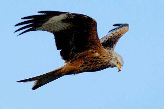
A red kite bird seen from the side, flying through a clear blue sky with its wings spread wide.
A red kite in flight over the Weseraue wetlands.

Weseraue Bird Protection Area ecosystems, habitats, and plant life

Ecologically, Weseraue is a complex of interconnected floodplain habitats centered on the Weser river and its formerly dynamic side channels. Inland waters, both standing and flowing, make up a substantial portion of the site and include the impounded reaches near the Schlüsselburg weir and a network of smaller, often slow-moving marshland channels. These waters provide open-water and shoreline conditions crucial for waterbirds throughout the year.

Fringing the river are zones of marsh, swamp, and reed vegetation, supporting species-rich waterside plant communities, alongside mesophilic and improved wet grasslands. Larger parts of the floodplain are used as damp meadows and pasture, with a significant proportion of the area under arable cultivation. The mix of wet grassland, marsh, and farmland gives the floodplain its characteristic mosaic character, which varies seasonally with water levels and agricultural use.

The protected area is also shaped by human-modified features that have acquired ecological value, including the Grube Baltus former extraction site, stabilized weir pools, and a network of drainage ditches and marshland depressions. Together these features sustain rare and sensitive habitat types at the state level, including remnant bog, swamp, and shoreline vegetation, and they underpin the site's designation as one of the most important waterbird landscapes in North Rhine-Westphalia.
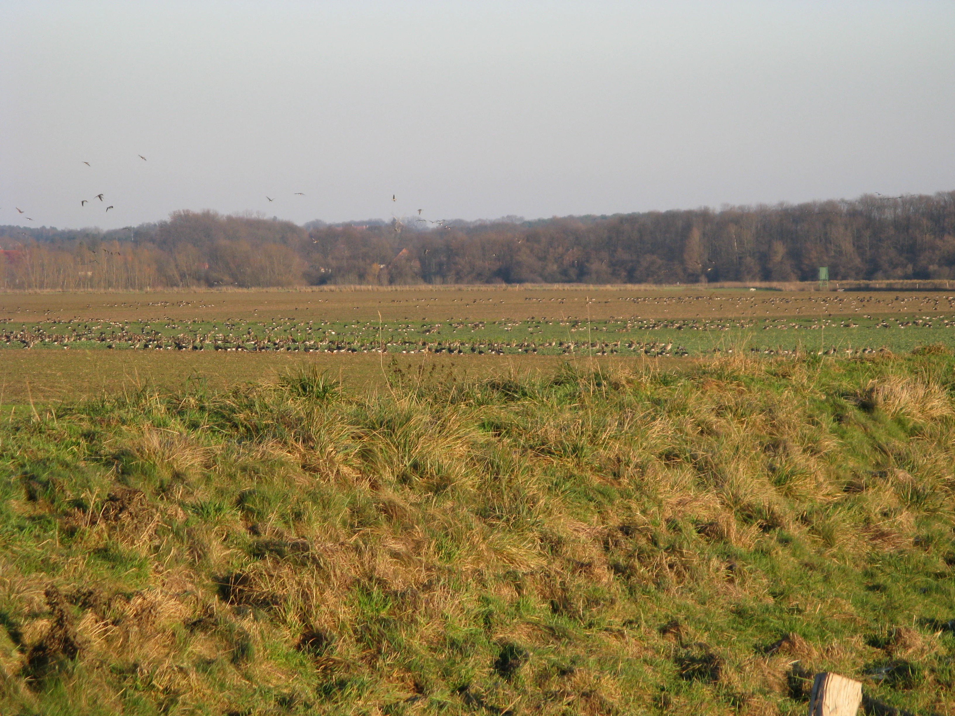
A wide view of a grassy field with a large flock of geese in the distance, framed by a grassy embankment in the foreground and a line of trees in the background.
A large flock of geese grazing in the wetlands of the Weseraue nature reserve.

Weseraue Bird Protection Area wildlife and species highlights

Weseraue is primarily significant for its birdlife, which is the core reason for its EU SPA designation. It is recognized as one of the most important breeding, moulting, staging, migratory stopover, and wintering areas for waterbirds and waders in North Rhine-Westphalia. During severe winters the Weser often remains only partially frozen, functioning as a last open-water refuge for ducks, mergansers, and divers, and the area hosts the state's most important wintering concentrations of Common Merganser and Common Goldeneye.

In spring and autumn the floodplain becomes a major staging site for migratory waterbirds and waders, with notable flocks of European Golden Plover, Bewick's Swan, Whooper Swan, Bean Goose, Greater White-fronted Goose, and a wide variety of ducks and waders. Breeding birds include White Stork, Marsh Harrier, Common Ringed Plover, Little Ringed Plover, Northern Lapwing, Eurasian Curlew, Black-tailed Godwit, Ruff, Common Snipe, Great Snipe, Eurasian Bittern, Common Kingfisher, Eurasian Penduline Tit, Bluethroat, Whinchat, Stonechat, Marsh Warbler, Sedge Warbler, and Sand Martin, along with riparian woodland species such as Eurasian Golden Oriole, Red Kite, Black Kite, and Eurasian Hobby. Waterbirds regularly nesting or staging on the site also include Gadwall, Garganey, Eurasian Teal, Northern Pintail, Northern Shoveler, Common Pochard, Tufted Duck, and Little Grebe, while passage terns such as Common, Little, and Black terns use the river and adjacent pools.

Beyond birds, the site's floodplain and marshland habitats support a range of typical wetland fauna tied to wet meadows, reedbeds, oxbows, and field edges, including amphibians, dragonflies, and small mammal communities that sustain the area's raptor and shrike populations, notably the Great Grey Shrike. The site's value for biodiversity thus extends well beyond its formal species list, contributing to a functional floodplain ecosystem along the middle Weser.

Weseraue Bird Protection Area conservation status and protection priorities

The conservation purpose of Weseraue is to maintain and develop the existing habitat structure of the floodplain together with its characteristic bird communities. Protection targets focus on securing and restoring the feeding areas of White Stork, the staging and wintering ranges of Bewick's Swan, Whooper Swan, Greater White-fronted Goose, and Bean Goose, the staging grounds of European Golden Plover, and the breeding areas of Marsh Harrier, waders, waterbirds, Bluethroat, Sedge Warbler, and Sand Martin.

For migratory species, the management priority is to maintain large, open landscapes with clear sightlines and uninterrupted flight corridors, preserve suitable feeding habitats, retain dynamic floodplain areas with near-natural flooding regimes, protect roost and wintering sites from disturbance, and stabilize high groundwater levels in wet meadows and other wetland habitats. For breeding species, conservation efforts emphasize the protection of marshland, oxbows, reedbeds, undisturbed wet meadows, near-natural riparian woodland, steep erosion banks for hole-nesting birds such as Kingfisher and Sand Martin, and structurally rich cultural landscapes that support raptors such as Red Kite, Black Kite, and Eurasian Hobby.

Weseraue's significance within the EU Natura 2000 network is strongly linked to its function as a refuge for populations of waterbirds and waders that have declined elsewhere in intensively farmed lowlands. By integrating habitat protection, wetland restoration, agricultural extensification, and disturbance control, the site serves as an important reference area for floodplain conservation in northwestern Germany and contributes to broader connectivity along the Weser river system.

Weseraue Bird Protection Area cultural meaning and human context

The Weseraue floodplain lies in a region shaped by centuries of interaction between communities and the Weser river. Traditional land use, including hay meadows on the Lahder Marsch and surrounding marshlands, grazing by livestock, and small-scale extraction of sand and gravel in pits such as Grube Baltus, has shaped both the cultural landscape and its ecological character. The Weser itself has long functioned as a transport, trade, and settlement corridor, and the towns and villages along its banks, including Petershagen and Schlüsselburg, are closely tied to the river's history.

Today, the floodplain's cultural value is increasingly linked to its role as a shared landscape for nature conservation, traditional agriculture, and regional recreation, with the protected area reflecting a long-term compromise between human use and the preservation of one of the state's most important bird landscapes.

Top sights and standout views in Weseraue Bird Protection Area

Among the most distinctive features of Weseraue are its long, linear river-habitat mosaic stretching roughly 25 kilometers along the Weser, its dual character of free-flowing and impounded reaches, and its exceptionally high concentration of seasonal waterbird and wader activity. The site stands out in North Rhine-Westphalia as a refuge during severe frosts, a critical staging area for swans, geese, and Golden Plovers, and a breeding ground for emblematic floodplain species such as White Stork, Marsh Harrier, Common Kingfisher, Bluethroat, and Sand Martin.

Best time to visit Weseraue Bird Protection Area

The character of a visit to Weseraue changes markedly with the seasons, reflecting the rhythms of migration, breeding, and wintering that drive its importance. Late autumn through early spring is typically the most rewarding period for waterbirds, as the floodplain hosts large numbers of swans, geese, ducks, and waders, while the river itself often provides the last open-water refuge during severe frosts, concentrating divers, ducks, and mergansers along its banks.

Spring brings the arrival of breeding White Storks, Marsh Harriers, waders such as Northern Lapwing and Black-tailed Godwit, and songbirds of wet meadows and reedbeds. Summer offers the best chance to observe breeding raptors, Marsh Warblers, and Sand Martins along erosion banks. Across all seasons, the mix of river, marsh, meadow, and farmland produces a dynamic landscape in which bird activity is closely tied to water levels, weather, and agricultural cycles.

Monthly climate preview

Long term average temperature and precipitation rhythm recorded at representative coordinates

Weseraue Climate Normals and Measured Annual Weather Patterns

Representative baseline measurements capture the annual temperature progression and daily precipitation averages across Weseraue. Detailed monthly climate records provide comprehensive context for long term meteorological patterns at this location.
Annual mean9 °C
1 °C18 °C
Jan
Feb
Mar
Apr
May13°
Jun16°
Jul18°
Aug18°
Sep14°
Oct10°
Nov
Dec
Warmest month
July

18.5 °C

Coolest month
January

0.9 °C

Wettest month
July

2.3 mm/day

Driest month
April

1.4 mm/day

Park location guide

Geography guide, regional context, and park location map for Weseraue Bird Protection Area

Weseraue Bird Protection Area park geography, regions, and map view in Germany

Understand where Weseraue Bird Protection Area sits in Germany through a broader geographic reading of the surrounding landscape, nearby location context, and its mapped position within the national park landscape.

How Weseraue Bird Protection Area fits into Germany

Germany is a federal republic in Western and Central Europe with a population of over 83 million across sixteen constituent states. It is Europe's largest economy by nominal GDP and a major global exporter and importer. The capital is Berlin, and the country borders Denmark, Poland, Czech Republic, Austria, Switzerland, France, Luxembourg, Belgium, and the Netherlands.

Wider geography shaping Weseraue Bird Protection Area in Germany

Germany is located in Western and Central Europe, spanning 357,022 km². It borders Denmark to the north, Poland and the Czech Republic to the east, Austria and Switzerland to the south, and France, Luxembourg, Belgium, and the Netherlands to the west. The country has coastlines on the Baltic Sea and North Sea to the north, with the Alps located in the southern region.

Map view of Weseraue Bird Protection Area

Use this park location map to pinpoint Weseraue Bird Protection Area in Germany, understand its exact geographic position, and read its mapped placement within the surrounding landscape more clearly.

Pigeon | © OpenStreetMap contributors

Location context for Weseraue Bird Protection Area

Nordrhein-Westfalen

Explore floodplain habitats, marshlands, and river terrain through protected area photography.

Weseraue Photos and Protected Area Scenery: Visualising the River Floodplain

Visual records capture the wetland mosaic, river channels, and open meadows defining the Weseraue floodplain. Examining these field photographs reveals the distinctive environmental character supporting regional waterbird populations.

A common kingfisher bird with vibrant blue and orange plumage, perched on a thin brown branch against a soft green out of focus background.

A Great Grey Shrike bird perched on a thorny, frost-covered branch, holding a small rodent in its beak.

A red kite bird seen from the side, flying through a clear blue sky with its wings spread wide.

A wide view of a grassy field with a large flock of geese in the distance, framed by a grassy embankment in the foreground and a line of trees in the background.

Park atlas

Compare adjacent river floodplains, wetland habitats, and connected conservation landscapes

Explore Parks Near Weseraue and Protected Areas in the Surrounding Region

Browse protected areas and river valley reserves located close to Weseraue to compare regional wetland habitats and floodplain ecosystems. Extending the search helps reveal connected conservation networks and broader ecological corridors across the surrounding landscape.
A horizontal watercolor painting depicting a soft, impressionistic forest landscape with green trees, subtle hints of pink and purple, and a light background.
Nature reserveNorth Rhine-Westphalia
About 7 km away#1 closest

Southwest

Heisterholz: Protected Oak Forests and Wetland Mosaics in North Rhine-Westphalia

Geographic overview of a key nature reserve and forest belt

Explore the structured geography of Heisterholz, a state-protected lowland forest in the Rahden-Diepenauer Geest. This site details the composition of its oak-dominated woodlands, spring zones, and stream valleys, illustrating its critical function within the interconnected forest chain of northern Germany.

Area
8.8 km²
Relief
Lowland
Climate
Temperate
Scope
Terrestrial
Watercolor illustration of a peaceful lakeside scene at Lahder Marsch, featuring birch trees, marshy vegetation, and a calm water surface.
Nature reserveKreis Minden-Lübbecke
About 7.4 km away#2 closest

South

Lahder Marsch Nature Reserve: Protected Wetland Mosaic in Kreis Minden-Lübbecke

A mapped sanctuary for migratory birds within the Weser floodplain.

Lahder Marsch is a designated nature reserve located in the Weser river valley, forming a chain of flooded gravel pits that sustain diverse avian populations. This protected landscape, characterized by open water, islands, and dense reed fringes, serves as a crucial habitat within the larger Weseraue Natura 2000 network, illustrating the geographic importance of restored extraction sites in lowland Germany.

Area
0.19 km²
Water
Major water bodies
Nature reserveLower Saxony
About 12 km away#3 closest

East

Steinhuder Meer mit Randbereichen: Protected Nature Reserve and Wetland Geography

Lowland lake, fen meadows, and bog ecosystems in Lower Saxony

Steinhuder Meer mit Randbereichen stands as a primary conservation site in northwestern Germany. The protected landscape combines a vast, shallow lowland lake with extensive reed belts and peatland remnants, creating a complex wetland gradient that defines the regional geography of the Weser-Aller lowlands.

Area
53.71 km²
Established
2004
Nature reserveNorth Rhine-Westphalia
About 13 km away#4 closest

West

Mindenerwald Protected Nature Reserve: Geography, Boundaries, and Forest Terrain

A vital deciduous woodland complex in northern North Rhine-Westphalia.

The Mindenerwald nature reserve represents a substantial forest tract characterized by sandy-soil oak woodlands and diverse ash-alder wetlands. This protected landscape serves as a critical node for habitat connectivity, hosting a complex mosaic of spring-fed marshes and mature trees that support important bird and bat species within the broader Minden-Lübbecke district.

Area
8 km²
Relief
Lowland
Scope
Terrestrial
Water
Minor water
Nature reserveNienburg/Weser
About 18 km away#5 closest

North

Wellier Schleife/Staustufe Landesbergen: A Protected River Oxbow and Floodplain Geography

Mapping protected habitats in the Middle Weser valley of Germany.

This nature reserve protects the Wellier Schleife, a significant oxbow arm created by the Landesbergen weir. The 278-hectare area encompasses former gravel pits, wetland fringes, and agricultural floodplains. It stands as a vital component of the Wesertalaue bei Landesbergen bird protection network, reflecting the interplay between river engineering and conservation efforts.

Area
2.78 km²
Established
1996
IUCN
IV
Relief
Lowland
Nature reserveLower Saxony
About 18 km away#6 closest

East

Westufer Steinhuder Meer Nature Reserve: Geographic Profile and Wetland Boundaries

Protected mosaic of swamp forest and bog in Lower Saxony

Westufer Steinhuder Meer represents a significant wetland complex within the Natura 2000 network of Lower Saxony. The protected area features a unique concentric gradient ranging from lakeshore reedbeds to inland fen and bog forest. By mapping these interconnected peat habitats, the reserve highlights its role as a key stopover for migratory waterfowl and a sanctuary for rare breeding species on the North German Plain.

Area
6.63 km²
Established
2020
A wide watercolor illustration showing a misty landscape with soft purple mountains in the distance and pink and green grasses in the foreground against a white background.
Nature reserveGermany
About 21 km away#7 closest

Northwest

Steinbrinker-Ströhener Masch: Nature Reserve and Wetland Protected Area in Lower Saxony

Mapping the fen peat grasslands and moorland buffers of Germany.

Steinbrinker-Ströhener Masch is an essential protected site in northwestern Germany, characterized by low-lying fen peat soils and expansive wet grasslands. Functioning as a key link within the Diepholzer Moorniederung, the area preserves critical habitat for meadow-breeding birds, shaped by seasonal waterlogging and traditional low-intensity land management techniques.

Area
3.25 km²
Established
1991
Relief
Lowland
Climate
Temperate
Nature reserveNorth Rhine-Westphalia
About 22 km away#8 closest

Southwest

Wittekindsberg Nature Reserve: Mapping Protected Forests and Jurassic Cliffs in Germany

A conservation-focused geographic analysis of the Wiehengebirge ridge

Wittekindsberg Nature Reserve represents a key protected landscape in northeastern North Rhine-Westphalia. Spanning the crest of the Wiehengebirge, the area is characterized by a mosaic of beech-dominated forests and Jurassic-age geological features. This atlas entry provides essential context on the reserve's topography, cliff-face habitats, and its role as a representative ecological site within the larger Natura 2000 network of the region.

Area
1.143 km²
Established
1990
IUCN
IV
Relief
Mountain

Common questions about visiting, size, designation, and location context for Weseraue Bird Protection Area

Weseraue Bird Protection Area FAQs for park facts, access, geography, and protected area context

Find quick answers about Weseraue Bird Protection Area, including protected-area facts, park geography, trail and visitor context, and how the park fits into its surrounding country and regional landscape.
MoriAtlas Explorer

Continue Your Protected Areas Search Across the Global Atlas

Deepen your exploration by continuing the structured search for national parks and protected areas worldwide. Utilize the comprehensive filtering capabilities to compare different conservation landscapes and refine your understanding of global park geography. Discover more about the distribution and characteristics of protected natural areas.

Global natural geography