

Mori Atlas logo
Marine protected areaWest Cape York Marine Park

A vital transition zone bridging the Gulf of Carpentaria and the Torres Strait marine systems

West Cape York Marine Park: Mapped Geography and Protected Marine Landscapes of Queensland

West Cape York Marine Park encompasses over 16,000 square kilometers of tropical marine waters offshore of Queensland, Australia. This protected area functions as a critical refuge for threatened sea turtle populations between nesting events and serves as an important roosting habitat for migratory frigate birds. By straddling the Northern Shelf and Northeast Shelf Transition provinces, the park sustains complex marine biodiversity across its tiered habitat and special purpose zones.

marine parktropical watersGulf of Carpentariasea turtlesfrigate birdsmarine conservation

West Cape York Marine Park

Marine protected area

Park overview

Structured park overview, official facts, and landscape profile for West Cape York Marine Park

West Cape York Marine Park park facts, protected area profile, and essential visitor context

Review the core facts for West Cape York Marine Park, including designation, size, terrain, visitor scale, habitats, and operating context in one park-focused overview.

About West Cape York Marine Park

West Cape York Marine Park sits in tropical waters off the northwest coast of Queensland, immediately west of the Cape York Peninsula. As part of Australia's national network of marine parks, it plays a strategic role in protecting the marine environment of the far north, where the Gulf of Carpentaria meets the broader Coral Sea region. The park's offshore location places it away from dense coastal development, allowing it to safeguard large areas of relatively undisturbed seabed, open water, and pelagic habitat.

The park's biodiversity reflects its position at the intersection of two major marine biogeographic regions. The Northern Shelf Province provides the productive coastal and basin environments of the Gulf of Carpentaria, known for high productivity, strong aggregations of marine life, and notable endemism. The Northeast Shelf Transition Province contributes the influence of Torres Strait waters, creating an ecological gradient within the park. This combination gives West Cape York Marine Park an unusually rich mix of tropical marine ecosystems.

West Cape York Marine Park is also notable for its tiered protection framework. While the overall park is classified under IUCN Category IV, it contains a strongly protected National Park zone, a Habitat Protection zone, and a Special Purpose zone. This approach balances conservation of key habitats, particularly for sea turtles and seabirds, with regulated use of surrounding waters. Managed by Parks Australia, the park is one of eight reserves in the North Marine Parks Network and represents a significant component of Australia's marine conservation estate in tropical waters.

Quick facts and research context for West Cape York Marine Park

West Cape York Marine Park is an offshore marine park located in tropical Queensland waters, west of the Cape York Peninsula and adjacent to the Gulf of Carpentaria. It covers around 16,012 square kilometers and is classified as IUCN Category IV overall, while internal zones include IUCN Category II National Park areas. The park is managed by Parks Australia within the larger North Marine Parks Network.

The park encompasses ecosystems from two provincial bioregions: the Northern Shelf Province, including the Carpentaria and West Cape York mesoscale bioregions, and the Northeast Shelf Transition Province, which includes the Torres Strait mesoscale bioregion. It provides important internesting habitat for flatback, hawksbill, and olive ridley turtles, and supports migratory frigate bird aggregations. The park was originally proclaimed in 2013 and brought under its first active management plan in July 2018.

Protection and recognition

Documented marine protection framework and established designation timeline

West Cape York Marine Park Protection Status and Designation History

Marine protection status and designation records for West Cape York Marine Park outline its established conservation scope since 2013. Structured governance facts provide clear reference details for regional protected area analysis and maritime geography study.

Protection details

Protection scope
Marine
Designated year
2013
Transboundary protection
No
Park context

Deeper park guide and search-rich context for West Cape York Marine Park

West Cape York Marine Park history, landscape, wildlife, and travel context

Explore West Cape York Marine Park through its history, landscape character, ecosystems, wildlife, conservation priorities, cultural context, and seasonal travel timing in a structured park guide built for atlas discovery and search intent.

Why West Cape York Marine Park stands out

West Cape York Marine Park is best known for protecting internationally significant sea turtle internesting habitat. It serves as an important resting area for flatback, hawksbill, and olive ridley turtles between egg-laying events, making it a critical refuge for these threatened species. The park is also recognized for its biodiversity-rich waters that bridge the Gulf of Carpentaria and the Torres Strait. These waters are highly productive and support aggregations of marine life, while also providing roosting habitat for migratory frigate birds. Together, these features make the park a key tropical marine conservation area in northern Australia.

West Cape York Marine Park history and protected-area timeline

West Cape York Marine Park was first proclaimed under Australia's Environment Protection and Biodiversity Conservation Act on 14 December 2013, at that time under the name West Cape York Commonwealth Marine Reserve. The renaming to West Cape York Marine Park occurred on 9 October 2017, aligning the area with the broader Australian marine parks framework.

The park's first management plan and associated protection measures came into effect on 1 July 2018. This marked the transition from a proclaimed reserve to an actively managed marine park, with defined zones, permitted activities, and conservation rules. Since then, the park has operated as part of the North Marine Parks Network alongside seven other Australian marine parks in tropical northern waters.

West Cape York Marine Park landscape and geographic character

The landscape of West Cape York Marine Park is defined entirely by tropical marine environments. Its waters lie off the western side of the Cape York Peninsula and extend into the eastern Gulf of Carpentaria. The terrain consists of open ocean, shelf waters, and basin environments rather than terrestrial landforms, giving the park a vast, seascape character.

The Gulf of Carpentaria coastal zone within the park is known for being highly productive, with biodiversity, endemism, and aggregations of marine life concentrated along the shelf margins. Deeper into the park, the Gulf of Carpentaria basin adds further depth and habitat complexity, supporting distinct ecological communities. The overall seascape forms a transitional zone between the shallow, productive gulf waters and the influences of the Torres Strait further north.

West Cape York Marine Park ecosystems, habitats, and plant life

The marine park encompasses ecosystems drawn from two provincial bioregions recognized in the Integrated Marine and Coastal Regionalisation of Australia: the Northern Shelf Province and the Northeast Shelf Transition Province. Within these, the park includes both the Carpentaria and West Cape York mesoscale bioregions as well as the Torres Strait mesoscale bioregion. This makes the park an ecological meeting point between the Gulf of Carpentaria and the broader northern tropical shelf.

The Gulf of Carpentaria coastal zone is characterized by high productivity, biodiversity, and endemism, while the Gulf of Carpentaria basin adds further biodiversity value in deeper waters. These environments support rich aggregations of marine life, from plankton and fish communities to larger pelagic species, creating a foundation for the broader food web that includes the park's notable turtle and seabird populations.

West Cape York Marine Park wildlife and species highlights

The wildlife values of West Cape York Marine Park are strongly focused on marine and seabird species. The park is recognized as a significant internesting area, providing resting habitat for three threatened sea turtle species between egg-laying events. These are the flatback turtle, hawksbill turtle, and olive ridley turtle, all of which depend on the park's waters during their reproductive cycles.

The park is also an important roosting area for migratory frigate birds, which aggregate in the region in large numbers. These seabird colonies indicate productive foraging conditions in surrounding waters. Together, the turtle and seabird values highlight the park's role in supporting both resident and migratory species that depend on the tropical marine environment of northern Australia.

West Cape York Marine Park conservation status and protection priorities

West Cape York Marine Park plays an important role in Australia's tropical marine conservation framework. Its waters overlap with highly productive and biodiversity-rich areas of the Gulf of Carpentaria, a region valued for high productivity, biodiversity, endemism, and aggregations of marine life. By protecting these ecosystems, the park contributes to the long-term resilience of northern Australia's marine environment.

The park's zoning system strengthens its conservation role. A fully protected National Park zone within the marine park provides a strict no-take refuge for sensitive habitats, while Habitat Protection and Special Purpose zones regulate activities such as fishing and tourism to minimize impact. This tiered approach ensures that the most ecologically important areas, including critical sea turtle internesting habitat, receive the highest level of protection.

Top sights and standout views in West Cape York Marine Park

West Cape York Marine Park's most distinctive features are its protected sea turtle internesting habitat, its position across the Gulf of Carpentaria and Torres Strait ecological transition, and its tiered zoning system that includes a fully protected National Park zone. These elements combine to make the park both ecologically rich and structurally important within Australia's marine conservation framework.

The park also stands out for its scale and offshore character, covering roughly 16,012 square kilometers of tropical waters. Its combination of coastal zone productivity and deeper basin habitat supports aggregations of marine life, making it a significant refuge for threatened turtles and migratory seabirds in one of Australia's most biodiverse marine regions.

Best time to visit West Cape York Marine Park

Because West Cape York Marine Park is a remote offshore marine park, the character of a visit is shaped mainly by tropical marine seasonality rather than terrestrial weather patterns. The region's tropical climate means warm waters year-round, with a distinct wet season and dry season influencing sea conditions, wildlife behavior, and sea turtle nesting cycles.

The turtle internesting habitat value of the park is most relevant during the nesting season, when female turtles move between nesting attempts and the broader turtle life cycle is active in northern Australian waters. Seabird aggregations and general marine productivity also fluctuate with seasonal oceanographic conditions in the Gulf of Carpentaria.

Monthly climate preview

Long-term representative temperature and precipitation averages recorded monthly

West Cape York Marine Park Climate Normals and Annual Weather Patterns

Representative baseline coordinates for West Cape York Marine Park record consistent monthly temperature ranges alongside distinct seasonal precipitation fluctuations across the year. Reviewing the complete twelve-month climatology dataset clarifies long-term thermal rhythms and moisture patterns.
Annual mean27 °C
25 °C29 °C
Jan28°
Feb28°
Mar28°
Apr28°
May27°
Jun26°
Jul25°
Aug25°
Sep26°
Oct27°
Nov28°
Dec29°
Warmest month
December

28.6 °C

Coolest month
August

25 °C

Wettest month
January

13.9 mm/day

Driest month
September

0.1 mm/day

Park location guide

Geography guide, regional context, and park location map for West Cape York Marine Park

West Cape York Marine Park park geography, regions, and map view in Australia

Understand where West Cape York Marine Park sits in Australia through a broader geographic reading of the surrounding landscape, nearby location context, and its mapped position within the national park landscape.

How West Cape York Marine Park fits into Australia

Australia is a constitutional monarchy and federal parliamentary democracy comprising six states and ten territories. With a population of nearly 28 million, it is one of the world's most urbanised countries, with most people concentrated on the eastern seaboard. The country has a high Human Development Index and is known for its cultural diversity, ancient Aboriginal heritage, and unique wildlife.

Wider geography shaping West Cape York Marine Park in Australia

Australia occupies the entire Australian continent, the island of Tasmania, and numerous smaller islands. It is the world's flattest and driest inhabited continent, featuring vast deserts in the interior (the Outback), tropical rainforests along the eastern coast, and a coastline bordering the Indian and Pacific Oceans.

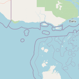
Map view of West Cape York Marine Park

Use this park location map to pinpoint West Cape York Marine Park in Australia, understand its exact geographic position, and read its mapped placement within the surrounding landscape more clearly.

Pigeon | © OpenStreetMap contributors

Location context for West Cape York Marine Park

Queensland
Park atlas

Compare surrounding marine reserves and regional tropical habitats

Explore Protected Areas Near West Cape York Marine Park

Browse other marine parks and protected areas located near West Cape York Marine Park across northern Australian waters. Comparing these regional conservation zones provides a broader geographic understanding of tropical marine habitats.
National parkAustralia
About 150 km away#1 closest

East

Possession Island National Park: National Park Atlas and Mapped Geographic Context

Australia's protected natural terrain and park boundaries.

Possession Island National Park serves as a vital point of discovery for understanding Australia's protected lands. This national park provides detailed insights into its specific geographic setting and landscape character, contributing to a broader atlas of natural territories. Engage with its mapped boundaries and unique terrain to grasp its significance within the country's conservation landscape. It is an essential component for anyone exploring the geography of Australian national parks.

A wide watercolor illustration showing green hills in the distance, a body of shallow water with pink and green patches, and foreground vegetation including green grasses and pink coral-like structures.
Marine protected areaQueensland
About 165 km away#2 closest

Southeast

Great Barrier Reef Marine Park: Atlas and Geographic Context for Queensland Protected Waters

Exploring the reef system and marine conservation zones in northeastern Australia

The Great Barrier Reef Marine Park stands as an internationally significant marine protected area. By spanning a massive stretch of the Queensland coast, this protected landscape provides a critical framework for marine governance and reef conservation. Users can examine the unique zoning and distribution of coral reef habitats that define this extensive tropical ecosystem.

Area
343,966 km²
Established
1975
Climate
Tropical
Scope
Marine
Protected areaQueensland
About 167 km away#3 closest

North

Warul Kawa Indigenous Protected Area: A Geographic Profile of a Remote Torres Strait Sand Cay

Protecting northern Australian reef platforms and marine habitats

Warul Kawa Indigenous Protected Area, or Deliverance Island, defines a unique landscape of sand cays and shallow algal reef platforms in the far north of Queensland. As a key site for flatback turtle breeding and migratory green turtles, the area offers a rare example of a near-pristine marine environment. Its geography highlights the intersection of Indigenous land management and high-integrity tropical island ecosystems.

Established
2001
Relief
Lowland
Climate
Tropical
Access
Remote access
National parkQueensland
About 177 km away#4 closest

East

Apudthama National Park: Queensland National Park Protected Landscape Geography

Explore the mapped boundaries and regional context.

Apudthama National Park offers a distinct national park experience within Queensland, Australia, focusing on its protected area identity and geographic landscape. This entry provides critical atlas-level information, detailing the park's mapped boundaries and its position within the regional geography. Understand the specific natural terrain and conservation context of this significant protected land.

Area
2,370 km²
Established
1994
IUCN
II
Relief
Lowland
National parkSouth Papua
About 200 km away#5 closest

North

Wasur National Park National Park: Mapped Protected Boundaries in South Papua

Explore the geographic context and park boundaries.

Delve into the specific protected area identity of Wasur National Park, a national park situated within the South Papua region. This page offers detailed geographic context, focusing on its mapped boundaries and its significance as a protected landscape. It provides a factual basis for understanding the park's place within Indonesia's network of natural areas for structured atlas exploration.

Area
4,138 km²
Established
1990
IUCN
II
Visitors
2.3K annual
National parkAustralia
About 216 km away#6 closest

East

Yamarrinh Wachangan Islands (Denham Group) National Park: Australian Protected Landscape Map and Geography

Mapped boundaries and regional geographic context within Australia.

This detail entry for Yamarrinh Wachangan Islands (Denham Group) National Park provides specific geographic context and atlas information for this Australian national park. It focuses on the protected landscape identity, mapped features, and regional setting, offering a factual foundation for understanding the park's place within Australia's protected areas network. Explore its unique geographic characteristics and its designation as a national park.

Wildlife reserveWestern Province
About 221 km away#7 closest

North

Tonda Wildlife Management Area: Atlas of Protected Wetlands and Savanna Landscapes

Geographic overview of Papua New Guinea's largest wetland conservation zone

Spanning nearly 6,000 square kilometres of floodplain, Tonda Wildlife Management Area is defined by its exceptionally flat terrain and shifting mosaic of monsoon forest, tidal channels, and freshwater marshes. This protected landscape functions as an essential ecological bridge within the Trans-Fly ecoregion, maintaining deep connections to international conservation partners while preserving the integrity of its native bird and mammal habitats.

Area
5,900 km²
Established
1975
National parkQueensland
About 228 km away#8 closest

East

Saunders Islands National Park: National Park Geography and Mapped Protected Landscape in Queensland

Explore the mapped terrain and protected area context.

Saunders Islands National Park represents a significant protected area within the geography of Queensland, Australia. This entry provides detailed atlas-level insights into its specific geographic boundaries and the nature of its protected landscape. Users can understand the park's regional placement and its mapped natural terrain, offering a concrete point for exploring Queensland's diverse protected lands and their unique environmental characteristics.

Area
0.19 km²
Established
1989
IUCN
II
Climate
Tropical

Common questions about visiting, size, designation, and location context for West Cape York Marine Park

West Cape York Marine Park FAQs for park facts, access, geography, and protected area context

Find quick answers about West Cape York Marine Park, including protected-area facts, park geography, trail and visitor context, and how the park fits into its surrounding country and regional landscape.
MoriAtlas Explorer

Continue Your Protected Areas Search Across the Global Atlas

Deepen your exploration by continuing the structured search for national parks and protected areas worldwide. Utilize the comprehensive filtering capabilities to compare different conservation landscapes and refine your understanding of global park geography. Discover more about the distribution and characteristics of protected natural areas.

Global natural geography

