
Mori Atlas logo
Nature reserveWestlich Berus

Mapping the calcareous grasslands, tufa springs, and beech forests on the German-French border

Westlich Berus Nature Reserve: A Detailed Geographic Atlas of Saarland Protected Landscapes

(Naturschutzgebiet Westlich Berus)

Westlich Berus encompasses a unique mosaic of priority habitats spanning roughly 143 hectares along the international border of Saarland. This nature reserve provides a critical study of limestone geography, where submediterranean dry grasslands intersect with mature beech forests and spring-fed wetlands. The terrain serves as a vital ecological node, showcasing the diverse micro-topography and protected limestone formations characteristic of the Saar-Lorraine border region.

calcareous grasslanddry grasslandorchid-rich meadowtufa springsbeech forestravine forest
A stylized digital illustration of a valley between rocky mountains under a sunny sky with a waterfall on the right and a signpost in the foreground.

Westlich Berus

Nature reserve

Park overview

Structured park overview, official facts, and landscape profile for Westlich Berus

Westlich Berus park facts, protected area profile, and essential visitor context

Review the core facts for Westlich Berus, including designation, size, terrain, visitor scale, habitats, and operating context in one park-focused overview.

About Westlich Berus

Westlich Berus is a small but ecologically rich nature reserve in Germany's Saarland, established in 2016 to protect one of the most diverse calcareous habitat complexes along the German–French border. Covering about 143 hectares on the western edge of the village of Berus, in the municipality of Überherrn and Landkreis Saarlouis, the reserve sits on the limestone slopes that form the natural interface between the Saarland and the French department of Moselle.

The protected area is administered under German nature reserve law and is also registered in the World Database on Protected Areas, where it is classified as an IUCN Category IV Habitat/Species Management Area. This designation reflects a management-oriented approach rather than a strict wilderness reserve, allowing active measures to maintain the open grassland and tufa seepage habitats that would otherwise be lost to succession.

The reserve's identity is shaped by its geology. Limestone bedrock underpins the entire area, producing the calcareous soils on which its distinctive vegetation depends. On the warmer, south-facing slopes this supports submediterranean semi-dry grassland belonging to the orchid-rich Festuco-Brometalia type, one of the most threatened plant communities in central Europe. In cooler, moister positions the same rock yields a network of small tufa-forming springs, rare in the region, where calcium-rich water deposits delicate travertine crusts. Steeper slopes and ravines carry mixed forests of lime, sycamore, and beech known as Tilio-Acerion woodland, while flatter ground supports low-intensity hay meadows of the Alopecurus–Sanguisorba type.

Together these habitats form an unusually compact but coherent mosaic, which is why Westlich Berus is listed for so many different European priority habitat types at once. The reserve also plays an important role in connecting protected sites on both sides of the border, fitting into a broader network of calcareous grassland and beech forest sites across the Saar–Lorraine region.

Quick facts and research context for Westlich Berus

Westlich Berus is a 143-hectare nature reserve (Naturschutzgebiet) located west of Berus, a district of Überherrn in Landkreis Saarlouis, Saarland. It was officially designated on 26 May 2016 under the German identifier NSG-N-6706-302 and corresponds to World Database on Protected Areas record 555632877, classified as an IUCN Category IV protected area.

The reserve lies directly on the German–French state border, around 49.27° N, 6.67° E, and protects a mosaic of priority European habitats, including submediterranean orchid-rich dry grassland, calcareous tufa springs, slope and ravine mixed forests, whitebeam and beech woods, nutrient-poor calcareous ponds, and species-rich hay meadows on limestone. Its habitat complex supports protected amphibians such as the great crested newt and yellow-bellied toad, the large copper butterfly Lycaena dispar, and woodland bats including the western barbastelle and the greater mouse-eared bat.

Protection and recognition

Documented conservation records and official protected area designations

Westlich Berus Protection Status and International Recognition Data

Examine the verified protection status and management scope recorded for Westlich Berus within international conservation databases. Review structured administrative records and official designation entries compiled for this protected landscape.

Protection details

WDPA ID
555632877
Park context

Deeper park guide and search-rich context for Westlich Berus

Westlich Berus history, landscape, wildlife, and travel context

Explore Westlich Berus through its history, landscape character, ecosystems, wildlife, conservation priorities, cultural context, and seasonal travel timing in a structured park guide built for atlas discovery and search intent.

Why Westlich Berus stands out

Westlich Berus is best known as a textbook example of the calcareous, orchid-rich landscape of the Saar, Lorraine border country, with its striking mix of submediterranean dry grassland, tufa springs, and old beech forest on limestone. The reserve has particular value for its concentration of orchid-rich mesobromion semi-dry grassland, a habitat type rarely well-preserved in this part of western Germany, and for the rare combination on one site of priority habitats spanning open grassland, seepage wetlands, and mature deciduous woodland. Its location directly on the Franco-German border further enhances its role as a protected limestone island within a wider agricultural and forested landscape.
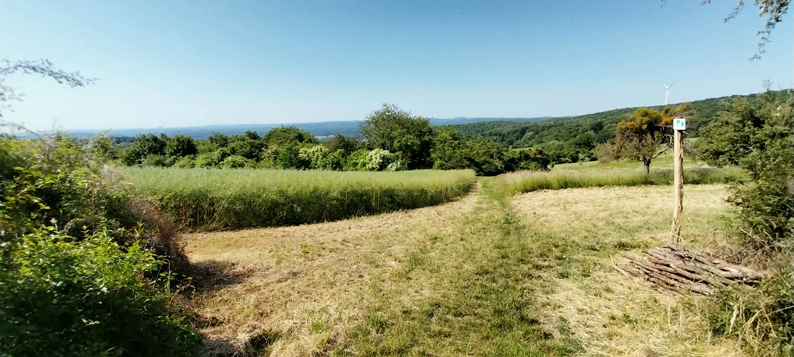
A sunny landscape view featuring a dirt path winding through golden grasses and green fields toward a distant forest line under a clear blue sky, with a simple wooden trail marker on the right.
A view across the agricultural and forested landscape within the Westlich Berus nature reserve.

Westlich Berus history and protected-area timeline

The protected area at Westlich Berus was established by formal ordinance of the Saarland Ministry for the Environment on 9 May 2016, with the regulation taking legal effect on 26 May 2016. Its purpose was to secure, in a single site of moderate size, the combination of calcareous grassland, tufa springs, and beech woodland that previous surveys had shown to exist around Berus.

The designation brought the area into the official list of nature reserves in Landkreis Saarlouis and aligned it with European habitat conservation frameworks, since several of the habitat types identified within the reserve correspond to priority types under the EU Habitats Directive. As an IUCN Category IV area, the reserve is managed to maintain, restore, and develop these habitats rather than left untouched.

Although the reserve itself is recent, the landscape it protects represents long-established traditional land use. The species-rich meadows and dry grasslands are products of centuries of low-intensity grazing and mowing, while the older beech stands on steep slopes have been shaped by historical forest management. The 2016 designation therefore formalized protection for an ecological mosaic that had already been sustained, almost by accident, by older farming and forestry practices.

Westlich Berus landscape and geographic character

The reserve occupies a piece of gently undulating limestone country typical of the northern edge of the Lorraine plateau. Elevations are modest, and the terrain is shaped more by shallow valleys, slopes, and limestone outcrops than by dramatic relief, but the layering of landform and rock produces a varied micro-topography within a small footprint.

West of the village of Berus, slopes alternate between warmer, south-exposed crests that have historically been kept open as grassland and cooler, north-facing flanks that carry mature deciduous woodland. Along the western edge of the area runs the international state boundary, here marked by a relatively unobtrusive landscape feature that nevertheless gives the reserve an exposed, borderland setting.

Calcareous bedrock appears at the surface in several places, producing thin, stony soils over which dry grassland has developed. Small tufa springs emerge where groundwater seeps from limestone, building up the soft, porous calcium deposits called Kalktuff that give the habitat type its name. Pools, ditches, and short flushes occupy the flatter valley bottoms, while steeper slopes and ravine-like incisions hold the mixed lime-ash-beech forest that characterizes the most wooded parts of the reserve.

Westlich Berus ecosystems, habitats, and plant life

Ecologically, Westlich Berus is defined by the fact that calcareous bedrock, mild Saarland climate, and traditional land use come together to produce a single site that hosts several rare and protected habitat types in close proximity. This convergence, rather than any single dramatic habitat, is what gives the reserve its conservation value.

The open land is dominated by submediterranean semi-dry grassland of the mesobromion type, here listed under the European habitat type 6210 with the special orchid-rich subtype 6212. In late spring and early summer these swards carry a notable diversity of orchids together with a rich mixture of other calcareous forbs, supported by the thin, base-rich soils that have been maintained through extensive grazing and mowing.

Around the springs and on flushes the habitat characters shifts abruptly. Where lime-rich groundwater emerges, it builds the small travertine terraces known as Kalktuffquellen (habitat type 7220), habitat for specialized bryophytes and vascular plants adapted to constant, calcium-saturated water. Slightly damper, flatter ground carries mesotrophic calcareous standing waters rich in stonewort algae (habitat 3140), while flatter meadows away from the springs belong to the species-rich hay-meadow type 6510. The woodland portion of the reserve includes ravine and slope forests of lime and sycamore (habitat 9180) on steeper ground and more extensive stands of beech forest of the Asperulo-Fagetum and Luzulo-Fagetum types (habitats 9110 and 9130) where the slope gentles and the soil deepens.

Westlich Berus wildlife and species highlights

The combination of ponds, seepages, dry grassland, mature woodland, and rocky outcrops within a small area makes Westlich Berus unusually rich in protected fauna. The reserve's amphibian interest is particularly striking, because the calcareous pools and tufa seeps provide exactly the kind of breeding habitat that many amphibians now lack elsewhere in the cultivated Saarland lowlands.

The great crested newt (Triturus cristatus) and yellow-bellied toad (Bombina variegata) are both listed explicitly as protected species of the reserve, the latter especially dependent on the small sun-exposed calcareous pools that persist in the flatter parts of the site. Midwife toads (Alytes obstetricans) are also recorded, using similar shallow water bodies and the surrounding stone-rich slopes.

The site's older woodland, with its mix of beech, ash, and lime together with rock crevices and slope features, provides roosting and foraging habitat for several bat species. The western barbastelle (Barbastella barbastellus) and the greater mouse-eared bat (Myotis myotis) are listed as key target species, alongside the lesser noctule (Nyctalus leisleri) and the brown long-eared bat (Plecotus auritus). The rare large copper butterfly (Lycaena dispar) occurs in the more open parts of the reserve, where its larval foodplants grow in the damp, calcareous grassland margins.

Westlich Berus conservation status and protection priorities

Westlich Berus is a conservation-focused site that was designated primarily to safeguard a rare combination of European priority habitats on a single, well-defined parcel of land. Because several of these habitat types, especially the orchid-rich submediterrane dry grassland and the tufa-forming springs, are difficult or impossible to restore once lost, the reserve's main task is to maintain current condition through appropriate management rather than relying on natural processes alone.

As an IUCN Category IV protected area, the reserve is managed actively. Mowing, grazing, and selective woodland intervention are used to prevent scrub encroachment on dry grassland, to keep the springs and their travertine formations open, and to sustain the age structure of beech and ravine forest in ways that support specialist bats and saproxylic species. The reserve is also part of the European network of protected grasslands and beech forests through the inclusion of its habitat types under the EU Habitats Directive.

Beyond its local role, Westlich Berus has a regional bridging function. It strengthens the network of calcareous grassland sites that runs across the Saar–Lorraine border country, helping connect protected populations of orchids, amphibians, and woodland bats on both sides of the Franco-German frontier.

Westlich Berus cultural meaning and human context

The reserve does not contain significant built heritage, but it sits within a landscape whose identity is deeply shaped by its history as a cross-border region. Berus itself lies on the German side just a few hundred meters from the French border, and for centuries this part of the Saarland has been a contact zone between German and French rural culture, language, and land use.

The open character of the reserve's dry-grassland slopes is itself a cultural artefact: these swards persist only because they were created and maintained by extensive mowing, grazing, and associated rural practices that go back generations. In that sense the orchid-rich meadows of Westlich Berus are part of the same cultural landscape as the historically French side of the border, where low-intensity farming has produced comparable habitat mosaics just across the frontier.

Top sights and standout views in Westlich Berus

Among the strongest points of distinction for Westlich Berus is its concentration of conservation value within a very compact area: across only around 143 hectares it brings together orchid-rich dry grassland, tufa-forming springs, calcareous ponds, ravine forest, and beech woodland in a single protected landscape.

The reserve is also particularly significant because several of its habitats are European priority types, including the orchid-rich subtype of mesobromion grassland and the regional population of great crested newt, yellow-bellied toad, and large copper butterfly. Its position on the Franco-German border adds a transboundary dimension that elevates what is, in surface terms, a fairly small nature reserve into a meaningful node in the wider Saar–Lorraine ecological network.

Best time to visit Westlich Berus

Late spring and early summer are the most rewarding period to experience the reserve, when the orchid-rich calcareous grassland is in flower and the tufa springs are at their most lively following winter recharge. Cooler mornings can be productive for hearing amphibian activity from the calcareous pools, while woodland tracks through the beech and ravine forest are most pleasant outside the hottest weeks of midsummer.

Autumn brings subtle change in the beech stands and is a good season for bats, since several of the protected bat species of the reserve concentrate around roost sites as conditions cool. In winter, deciduous trees drop their leaves and the structure of the mosaic, grassland against forest, becomes easier to read at landscape scale. Because the reserve is primarily a conservation site rather than a visitor attraction, any visit should be planned with low-impact, well-marked routes in mind.

Monthly climate preview

Track representative long term averages and recorded monthly weather patterns for Saarland

Westlich Berus Climate Normals, Annual Temperature and Monthly Precipitation Rhythms

Representative coordinate records show measured long term temperature swings and monthly precipitation rates spanning the annual cycle at Westlich Berus. Exploring the complete twelve month climate profile reveals deeper statistical breakdowns across every recorded period.
Annual mean9 °C
0 °C19 °C
Jan
Feb
Mar
Apr
May12°
Jun16°
Jul19°
Aug18°
Sep14°
Oct
Nov
Dec
Warmest month
July

18.6 °C

Coolest month
January

-0.2 °C

Wettest month
December

2.9 mm/day

Driest month
April

1.7 mm/day

Park location guide

Geography guide, regional context, and park location map for Westlich Berus

Westlich Berus park geography, regions, and map view in Germany

Understand where Westlich Berus sits in Germany through a broader geographic reading of the surrounding landscape, nearby location context, and its mapped position within the national park landscape.

How Westlich Berus fits into Germany

Germany is a federal republic in Western and Central Europe with a population of over 83 million across sixteen constituent states. It is Europe's largest economy by nominal GDP and a major global exporter and importer. The capital is Berlin, and the country borders Denmark, Poland, Czech Republic, Austria, Switzerland, France, Luxembourg, Belgium, and the Netherlands.

Wider geography shaping Westlich Berus in Germany

Germany is located in Western and Central Europe, spanning 357,022 km². It borders Denmark to the north, Poland and the Czech Republic to the east, Austria and Switzerland to the south, and France, Luxembourg, Belgium, and the Netherlands to the west. The country has coastlines on the Baltic Sea and North Sea to the north, with the Alps located in the southern region.

Map view of Westlich Berus

Use this park location map to pinpoint Westlich Berus in Germany, understand its exact geographic position, and read its mapped placement within the surrounding landscape more clearly.

Pigeon | © OpenStreetMap contributors

Location context for Westlich Berus

Saarland

Explore the unique protected scenery, calcareous grasslands, and borderland terrain of Westlich Berus through detailed visual documentation.

Westlich Berus Photos and Landscapes: Visualizing the Limestone Terrain and Habitats

Visual documentation reveals the intricate mosaic of calcareous grasslands, tufa springs, and mature beech forests that define Westlich Berus. Studying these protected landscapes provides direct insight into the rare habitats and borderland terrain characterizing the Saarland region.

A sunny landscape view featuring a dirt path winding through golden grasses and green fields toward a distant forest line under a clear blue sky, with a simple wooden trail marker on the right.

Park atlas

Compare surrounding regional nature reserves and connected borderland habitats.

Parks Near Westlich Berus and Related Protected Landscapes to Explore Next

Browsing other protected areas near Westlich Berus reveals the broader ecological continuity of the Saar region. Extending the geographic comparison helps trace similar limestone habitats and connected conservation terrain across nearby landscapes.
A soft, painterly watercolor illustration showing rolling green hills, distant ridgelines, and sparse trees against a white background.
Nature reserveGrand Est
About 9.7 km away#1 closest

West

Réserve naturelle régionale de la zone humide du moulin de Velving et Téterchen: Protected Wetland Atlas

Regional nature reserve geography and wetland habitat mapping in Moselle

This protected area spans nearly 92 hectares of marshland and meadow in the Pays de Nied. The reserve stands as a representative example of restored wetland environments in northeastern France, featuring distinct calcareous peatland habitats and thriving meadow-nesting bird communities nestled within the Bruchbach valley.

Area
0.93 km²
Established
2009
IUCN
IV
Relief
Lowland
Watercolor painting of a tranquil lake surrounded by soft green trees, grassy banks, and rolling hills in the background under a pale sky.
Protected areaSaarland
About 9.8 km away#2 closest

North

Dillinger See Protected Area: Saarland Floodplain Geography and Bird Sanctuary Map

Mapping wetland habitats and ecological terrain in Saarland

Dillinger See is a protected ecological lake situated within the Saar River floodplain in Saarland. This area serves as a sanctuary for diverse avian species, with its landscape defined by reed belts and restored island habitats. Learn about the geographic significance of this site as an EU bird protection area and its role in regional flood management.

Area
0.8 km²
Established
1980
Relief
Lowland
Access
Easy access
Nature reserveSaarland
About 11 km away#3 closest

East

Breitborner Floß Nature Reserve: Mapping the Protected Landscape and Geography of Saarland

A vital habitat complex across the Saarlouis district

Breitborner Floß stands as a significant protected nature reserve in the Saarland state of Germany. Covering a mosaic of alluvial forests, silicate grasslands, and wet meadows, the site serves as a prime example of compact landscape conservation. Explore the mapped boundaries and natural terrain features that define this key component of the European Natura 2000 network.

Area
0.39 km²
Established
2015
IUCN
IV
Relief
Upland
Nature reserveSaarland
About 25 km away#4 closest

North

Steilhänge der Saar Nature Reserve: Mapped Protected Landscapes and River Valley Geography

Protected river slopes and forested terrain in Saarland

The Steilhänge der Saar nature reserve encompasses steep, wooded hillsides rising above the Saar river valley. This consolidated protected area features complex ecological gradients between rocky, sun-exposed upper slopes and shadowed tributary streams, serving as a critical habitat zone and a defining feature of the regional Saarland landscape.

Area
10.86 km²
Established
2017
IUCN
IV
Nature reserveSaarland
About 28 km away#5 closest

Northeast

Wiesenlandschaft bei Überroth: Nature Reserve Geography and Mapped Meadow Habitats

Essential protected land analysis in the Saarland region of Germany

Wiesenlandschaft bei Überroth functions as a core protected area for species-rich meadows in southwestern Germany. This detailed entry maps its two-part configuration and explains its role within the regional Saarland habitat network, providing a clear geographic perspective on its conservation status and semi-natural terrain characteristics.

Area
2.87 km²
Established
2015
IUCN
IV
Relief
Lowland
A soft watercolor illustration depicting a panoramic landscape with rolling green hills, distant pink-hued mountains, and a rocky outcrop in the foreground.
Nature reserveSaarland
About 29 km away#6 closest

East

Birzberg, Honigsack/Kappelberghang bei Fechingen: Saarland Protected Nature Reserve Geography

Mapping the slope woodlands and riparian habitats near Saarbrücken

Spanning 188 hectares across the Saar valley margins, this nature reserve is defined by its varied hillside topography and calcareous soil influence. The protected area supports a complex mosaic of woodland slopes and grassland environments, providing a crucial habitat corridor within the Saarland region of Germany.

Area
1.88 km²
Established
2016
Nature reserveSaarland
About 30 km away#7 closest

East

Wusterhang und Beierwies bei Fechingen: Protected Nature Reserve and Habitat Map

A study of calcareous beech forests and meadow geography in Saarland

Wusterhang und Beierwies bei Fechingen is a specialized nature reserve that captures the essential habitat diversity of the Saarland region. The area is defined by its small-scale mosaic of woodruff beech forest, orchid-rich calcareous slopes, and nutrient-poor grasslands. By examining this protected site, you can better understand the intersection of forest and meadow ecosystems that define this specific part of southwestern German geography.

A horizontal watercolor painting of a wetland scene with still water, grassy banks, small islands, and rolling hills in the background.
Nature reserveSchengen
About 32 km away#8 closest

Northwest

Haff Réimech Nature Reserve: Wetland Geography and Protected Landscape in Schengen

Reclaimed industrial wetlands in the Moselle river valley

Haff Réimech is a protected wetland sanctuary located in the Moselle valley near Schengen. The reserve features approximately forty shallow lakes created from former sand and gravel pits, now surrounded by reedbeds and riparian woodland. This mosaic landscape serves as a key site for migratory bird species, demonstrating a unique transition from industrial extraction to a managed, ecologically rich floodplain environment.

Area
1.008 km²
Established
1998
Relief
Lowland
Climate
Temperate

Common questions about visiting, size, designation, and location context for Westlich Berus

Westlich Berus FAQs for park facts, access, geography, and protected area context

Find quick answers about Westlich Berus, including protected-area facts, park geography, trail and visitor context, and how the park fits into its surrounding country and regional landscape.
MoriAtlas Explorer

Continue Your Protected Areas Search Across the Global Atlas

Deepen your exploration by continuing the structured search for national parks and protected areas worldwide. Utilize the comprehensive filtering capabilities to compare different conservation landscapes and refine your understanding of global park geography. Discover more about the distribution and characteristics of protected natural areas.

Global natural geography