Mori Atlas logo
Nature reserveWestliche Hälfte des Langen Moores

A detailed map and landscape analysis of historic bog succession in Landkreis Osterholz

Westliche Hälfte des Langen Moores Protected Nature Reserve and Peatland Geography

(Naturschutzgebiet Westliche Hälfte des Langen Moores)

Westliche Hälfte des Langen Moores represents a critical nature reserve in the district of Osterholz, preserving the remnant microtopography of a historic peatland complex. This protected landscape exhibits a diverse mosaic of active highmoor vegetation and successional stages shaped by centuries of irregular peat extraction. The site serves as a vital botanical refugium within the Teufelsmoor region, offering insight into peatland regeneration across the lowland terrain of Lower Saxony.

raised boghighmoorpeatlandnature reserveLower SaxonyOsterholz district

Westliche Hälfte des Langen Moores

Nature reserve

Park overview

Structured park overview, official facts, and landscape profile for Westliche Hälfte des Langen Moores

Westliche Hälfte des Langen Moores park facts, protected area profile, and essential visitor context

Review the core facts for Westliche Hälfte des Langen Moores, including designation, size, terrain, visitor scale, habitats, and operating context in one park-focused overview.

About Westliche Hälfte des Langen Moores

Westliche Hälfte des Langen Moores is a compact yet ecologically meaningful nature reserve in the Teufelsmoor region of northern Lower Saxony. Although it spans only about eleven hectares, it carries a significance well beyond that size because it represents what survives of the formerly much larger Langen Moor, a peatland whose name still echoes in the cultural memory of Worpswede and the wider Osterholz district.

The reserve lies in the Gemarkung St. Jürgen within the municipality of Lilienthal, just east of Bremen. The local terrain is very flat by any alpine standard, sitting between roughly 4 and 12 meters above sea level, but the surface itself is far from uniform. Centuries of peat cutting, with differing depths and irregular boundaries, have left an intricate small-scale relief that today shapes water distribution, vegetation, and ecological processes across the reserve.

The site is administratively managed by the Lower Saxon Agency for Water Management, Coastal Defense, and Nature Conservation (NLWKN) and was placed under formal protection in 1984 under the German Naturschutzgebiet framework. Its international classification within the IUCN system as a Category IV protected area underscores its primary purpose as a managed habitat reserve for species and habitat types typical of northwest German raised bogs.

Quick facts and research context for Westliche Hälfte des Langen Moores

The Westliche Hälfte des Langen Moores nature reserve is located in the municipality of Lilienthal in the Osterholz district of Lower Saxony, north of the city of Bremen and adjacent to the Worpswede area. Designated on 18 January 1984 by the former Bezirksregierung Lüneburg, it carries the statistical code NSG LÜ 92 and is registered internationally with WDPA ID 166276.

It protects around 11 hectares of peatland at elevations between roughly 4 and 12 meters above sea level, managed by the Niedersächsischer Landesbetrieb für Wasserwirtschaft, Küsten- und Naturschutz (NLWKN). The reserve represents the western portion of the once extensive Langen Moor and holds high regional significance for the conservation of endangered highmoor plant species.

Protection and recognition

Examine the recorded designation history and administrative data for this protected area.

Westliche Hälfte des Langen Moores Protection Status and Records

Consolidated protection records provide clear insight into the official designation framework governing Westliche Hälfte des Langen Moores. Structured dataset entries outline verified conservation classifications and administrative assignments.

Protection details

WDPA ID
166276
Park context

Deeper park guide and search-rich context for Westliche Hälfte des Langen Moores

Westliche Hälfte des Langen Moores history, landscape, wildlife, and travel context

Explore Westliche Hälfte des Langen Moores through its history, landscape character, ecosystems, wildlife, conservation priorities, cultural context, and seasonal travel timing in a structured park guide built for atlas discovery and search intent.

Why Westliche Hälfte des Langen Moores stands out

The reserve is best known for preserving a remnant of the historic Langen Moor near Worpswede, with a distinctive microtopography created by irregular historical peat cutting. This uneven history of extraction has produced an unusually varied mosaic of intact raised bog vegetation, actively regenerating highmoor succession, and replacement plant communities on former peat-cutting and agricultural surfaces, making the site a textbook example of peatland regeneration stages in northwest German lowlands.
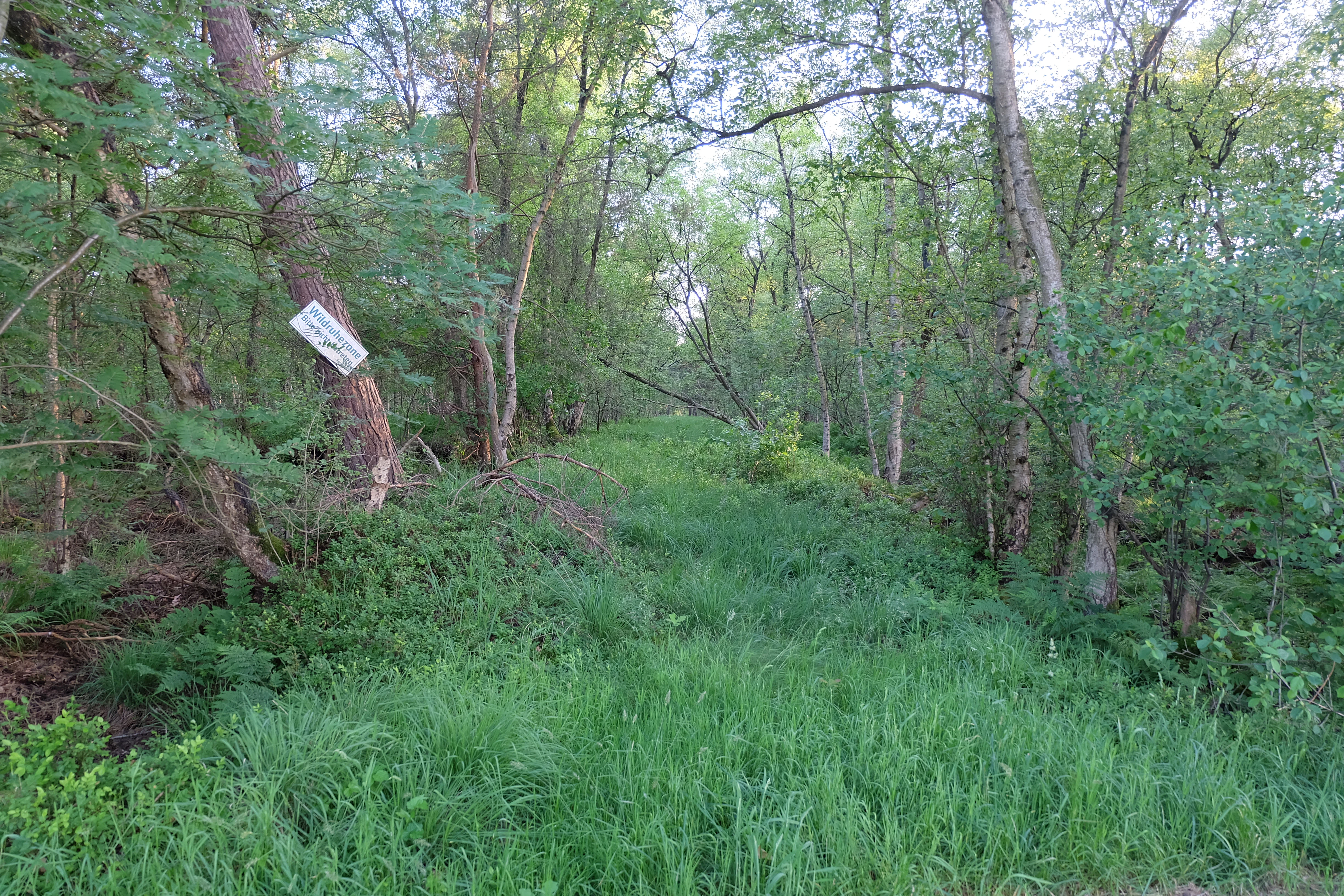
A dirt path partially overgrown with tall green grass leading into a thick, leafy forest in a nature reserve.
A narrow path winding through the dense forest and vegetation of the Westliche Hälfte des Langen Moores nature reserve.

Westliche Hälfte des Langen Moores history and protected-area timeline

The protected area was formally established on 18 January 1984 through an ordinance (Verordnung) issued by the former Bezirksregierung Lüneburg, the regional administrative authority of the time for Lower Saxony. The designation placed the area under the German Naturschutzgesetz as a Naturschutzgebiet, securing legal protection for what remained of the historic Langen Moor.

The reserve's character, however, is shaped by a longer human history of peatland exploitation. Originally, the Langen Moor was a substantially larger peatland complex. Parts of it, including portions of what is now the protected area, were worked for peat over generations, with cutting carried out at varying depths and along irregular, sometimes improvised boundaries. Agricultural use also affected the surroundings in earlier periods.

When commercial peat cutting eventually ceased, the abandoned surfaces began a slow ecological recovery. The 1984 protection ordinance effectively locked in this transition, preserving the resulting mosaic of intact bog remnants, regenerating succession, and replacement communities as a managed habitat area rather than as a wilderness reserve.

Westliche Hälfte des Langen Moores landscape and geographic character

The physical landscape of the reserve is defined by its flatness and by the subtle but ecologically decisive surface relief that historical peat cutting has imprinted on it. Elevations across the site range only from about 4 meters to 12 meters above sea level, yet within that narrow band the ground rises and falls in a complex pattern of small mounds, depressions, and transitional slopes.

This microtopography is a direct product of human use. In some parts of the reserve peat was extracted thoroughly and to significant depth, while in others cutting was partial, shallow, or never undertaken at all. The boundaries between these differently treated areas are irregular, producing the patchwork relief described in regional ecological descriptions of the site.

The result is a landscape that, in its lower and wetter zones, retains peat-forming conditions and active highmoor vegetation, while on the higher, drier, more disturbed surfaces displays the open, herbaceous character typical of regenerating bog degradation areas. The surrounding territory within the Teufelsmoor cultural landscape echoes this lowland, peat-dominated character.

Westliche Hälfte des Langen Moores ecosystems, habitats, and plant life

Ecologically, the reserve is a habitat mosaic rather than a uniform ecosystem. The intact central and less-disturbed portions still support raised bog (Hochmoor) vegetation typical of the northwest German plain, while the former peat-cut zones show a gradient of ecological succession stages as the bog surface slowly regenerates.

Among the recognizable habitat types are areas of actively growing highmoor vegetation, successional communities on degraded bog surfaces, and so-called replacement plant communities on land that saw earlier agricultural use. The combination of these stages in a tightly bounded area gives the reserve an unusually compact cross-section of peatland ecological states.

The site has particular botanical value. It is recognized regionally as having high importance for endangered plant species and for the conservation of highmoor habitat structures that have been heavily reduced across Lower Saxony through centuries of peat extraction and land conversion.

Westliche Hälfte des Langen Moores wildlife and species highlights

The protected area's wildlife significance is closely tied to its botanical and habitat character rather than to large charismatic mammals. The mosaic of wet bog vegetation, regenerating succession on degraded peat surfaces, and drier replacement communities provides niches for a specialized fauna adapted to peatland conditions, including invertebrates and bird species associated with open, wet, low-intensity landscapes.

Because the reserve is small and embedded in a broader agricultural and forestry matrix in the Teufelsmoor region, its principal value for wildlife lies in offering a stable refugium of peatland habitat types that are increasingly rare in the surrounding countryside. Detailed species inventories are not the focus of the published description, but the habitat structure itself is the basis for the reserve's species conservation value.

Westliche Hälfte des Langen Moores conservation status and protection priorities

Conservation significance at Westliche Hälfte des Langen Moores rests on the protection of a surviving fragment of what was once a considerably larger peatland. By sheltering an unusally varied microtopography of intact, regenerating, and degraded bog surfaces within a single small protected area, the reserve preserves a representative cross-section of highmoor ecological states that has largely vanished elsewhere in the district.

The reserve is classified as an IUCN Category IV protected area, indicating that its principal function is the managed conservation of particular habitats and species rather than strict wilderness preservation. Management is the responsibility of the Lower Saxon Agency for Water Management, Coastal Defense, and Nature Conservation (NLWKN), which oversees the site under the national Naturschutzgesetz framework.

Beyond its local value, the reserve contributes to the broader regional effort to maintain peatland-dependent biodiversity in the Teufelsmoor area near Worpswede, where most of the original extensive bogs have been lost to centuries of peat cutting and conversion.

Westliche Hälfte des Langen Moores cultural meaning and human context

The reserve sits within a region whose identity is inseparable from its peatland history. The Teufelsmoor, the larger cultural landscape surrounding Worpswede, has been shaped for centuries by peat cutting, small-scale moorland colonization, and the distinctive settlement patterns that emerged on reclaimed bog land. The Worpswede artists' colony, which put the broader region on the cultural map, drew much of its inspiration from these flat, atmospheric moor landscapes.

By preserving a fragment of the Langen Moor, the reserve also preserves a tangible link to that older land-use heritage, in which peat was a vital fuel and economic resource, and in which the boundary between exploited and conserved bog has shifted repeatedly over generations.

Top sights and standout views in Westliche Hälfte des Langen Moores

Among the reserve's strongest points of distinction is its unusually compact representation of different raised bog stages, from intact highmoor vegetation to active succession on former peat-cut surfaces, all within roughly eleven hectares. The irregular microtopography left by historical peat cutting is itself a highlight, as it controls water distribution and thereby plant communities across the site.

Equally notable is the reserve's role as a botanical refugium for endangered peatland plant species in the Osterholz district, and its position within the wider Teufelsmoor cultural landscape near Worpswede, where peatland history remains a defining element of regional identity.

Best time to visit Westliche Hälfte des Langen Moores

Because the reserve is a protected peatland habitat rather than a developed visitor site, timings for any potential visit are best guided by general conditions in the Teufelsmoor region rather than by published opening information. Late spring through early autumn typically offers the most accessible ground conditions and the most active display of highmoor and bog-succession vegetation, while wetter periods accentuating open water and peatland character tend to occur in the cooler months.

Visitors interested in observing bog vegetation, regeneration stages, and peatland microtopography will generally find the warmer half of the year more rewarding, when plant communities are most expressive and surface conditions are at their driest. Any actual visit should respect the protected status of the area and approach through the existing path network described in regional materials.


Monthly climate preview

Long-term temperature ranges and precipitation patterns across the protected landscape

Westliche Hälfte des Langen Moores Climate Normals and Monthly Weather Records

Historical data records the annual temperature progression and daily precipitation averages at a representative coordinate within Westliche Hälfte des Langen Moores. Examining these twelve-month baseline measurements provides clear insight into long-term climate normals and regional weather variation.
Annual mean9 °C
1 °C18 °C
Jan
Feb
Mar
Apr
May13°
Jun16°
Jul18°
Aug18°
Sep14°
Oct10°
Nov
Dec
Warmest month
July

18 °C

Coolest month
January

1 °C

Wettest month
July

2.5 mm/day

Driest month
April

1.4 mm/day

Park location guide

Geography guide, regional context, and park location map for Westliche Hälfte des Langen Moores

Westliche Hälfte des Langen Moores park geography, regions, and map view in Germany

Understand where Westliche Hälfte des Langen Moores sits in Germany through a broader geographic reading of the surrounding landscape, nearby location context, and its mapped position within the national park landscape.

How Westliche Hälfte des Langen Moores fits into Germany

Germany is a federal republic in Western and Central Europe with a population of over 83 million across sixteen constituent states. It is Europe's largest economy by nominal GDP and a major global exporter and importer. The capital is Berlin, and the country borders Denmark, Poland, Czech Republic, Austria, Switzerland, France, Luxembourg, Belgium, and the Netherlands.

Wider geography shaping Westliche Hälfte des Langen Moores in Germany

Germany is located in Western and Central Europe, spanning 357,022 km². It borders Denmark to the north, Poland and the Czech Republic to the east, Austria and Switzerland to the south, and France, Luxembourg, Belgium, and the Netherlands to the west. The country has coastlines on the Baltic Sea and North Sea to the north, with the Alps located in the southern region.

Map view of Westliche Hälfte des Langen Moores

Use this park location map to pinpoint Westliche Hälfte des Langen Moores in Germany, understand its exact geographic position, and read its mapped placement within the surrounding landscape more clearly.

Pigeon | © OpenStreetMap contributors

Location context for Westliche Hälfte des Langen Moores

Landkreis Osterholz

Visualizing the peatland habitats and microtopography of the protected nature reserve

Westliche Hälfte des Langen Moores Photos and Landscape Scenery

Visual records capture the unique microtopography and peatland regeneration stages across Westliche Hälfte des Langen Moores. Photographic exploration reveals the complex habitat mosaic shaped by historical extraction within the Teufelsmoor landscape.

A dirt path partially overgrown with tall green grass leading into a thick, leafy forest in a nature reserve.

Park atlas

Compare surrounding lowland habitats and regional nature reserves

Explore Protected Areas and Parks Near Westliche Hälfte des Langen Moores

Discover protected areas and regional nature reserves situated close to Westliche Hälfte des Langen Moores in the Osterholz district. Comparing these neighboring lowland habitats provides valuable geographic context on northwest German peatland landscapes.
Nature reserveBremen
About 5.4 km away#1 closest

Southwest

Untere Wümme Nature Reserve: Riverine Biodiversity and Protected Tidal Landscapes in Bremen

Protected floodplain geography and tidal river habitats.

This nature reserve protects the meandering lower course of the Wümme river, showcasing one of northern Germany's few freshwater tidal systems. Spanning reedbeds, willow forests, and open mudflats, the reserve forms a vital corridor for migratory fish and waterfowl, reflecting a complex mosaic of protected riverine ecosystems and historic meadow landscapes.

Area
1.485 km²
Established
1991
Relief
Lowland
Climate
Temperate
A pale, soft-toned watercolor illustration of a calm river meandering through open, green marshy meadows with distant rolling hills under a soft pink sky.
Nature reserveBremen
About 5.9 km away#2 closest

South

Borgfelder Wümmewiesen: Protected Wetland and Floodplain Geography in Bremen

An expansive 688-hectare nature reserve with river-fed grasslands.

Borgfelder Wümmewiesen offers a look at one of the largest protected nature reserves in the Bremen region. The landscape is characterized by its flat, open terrain and regular water dynamics that frame a rich mosaic of wet meadows, reedbeds, and ponds, providing essential habitat for breeding and migratory bird species along the Wümme river corridor.

Area
6.88 km²
Established
1987
Relief
Lowland
Climate
Temperate
A soft, painterly watercolor illustration depicting a winding river through a flat green meadow with rolling hills in the background.
Nature reserveBremen
About 6.9 km away#3 closest

South

Hollerland Nature Reserve: A Protected Cultural Landscape and Wetland in Bremen

Historic marshland terrain with unique saline spring ecosystems

Hollerland is a 293-hectare nature reserve in Bremen, Germany, notable for its well-preserved cultural landscape of wet grasslands and an intricate medieval ditch network. This protected area serves as a critical breeding ground for meadow birds and hosts an ecologically significant inland saline spring, providing a rare habitat for brackish-adapted plant communities deep within the regional landscape.

Area
2.93 km²
Established
1985
IUCN
IV
Relief
Lowland
Nature reserveBremen
About 8.2 km away#4 closest

Southwest

Kuhgrabensee Nature Reserve: Mapped Geography and Protected Areas in Bremen

An ecologically vital lake and bird sanctuary in Northwest Germany

Kuhgrabensee serves as a prime example of landscape restoration within Bremen, featuring a groundwater-fed lake with notable saline influences. This protected area supports a diverse array of pioneer plants and wildlife across its reed-lined shores and shallow-water habitats, providing a quiet corridor for ecological observation and study in the heart of the local landscape.

Area
0.296 km²
Established
1987
Relief
Lowland
Climate
Temperate
A watercolor painting showing a serene landscape with calm water, small islands of trees, and rolling hills in the background.
Nature reserveBremen
About 9.3 km away#5 closest

Southwest

Am Stadtwaldsee (Uni-Wildnis) Nature Reserve: Geographic Atlas and Park Map Context

Protected secondary habitat landscape in Bremen, Germany

Located in Bremen, the Am Stadtwaldsee (Uni-Wildnis) nature reserve offers a compelling study of secondary ecological succession. The area features a dense concentration of ponds and wooded ground shaped by historical sand mining. Explore the mapped boundaries of this eleven-hectare refuge to understand its role in urban biodiversity and regional landscape conservation.

Area
0.114 km²
Established
1991
IUCN
IV
A horizontal watercolor painting showing a tranquil lake scene with green trees, low-lying hills in the distance, and grassy banks against a white background.
Nature reserveBremen
About 12 km away#6 closest

West

Grambker Feldmarksee Nature Reserve: Mapping the Protected Landscapes of Bremen

A vital wetland sanctuary shaped by regional infrastructure and natural restoration

Grambker Feldmarksee offers a focused look at how post-industrial quarry sites evolve into ecologically dense nature reserves. This groundwater-fed lake in Bremen acts as a green island, showcasing mature woodland fringes and specialized wetland habitats that are integral to the local bird protection network.

Area
0.226 km²
Established
2009
Relief
Lowland
Climate
Temperate
Nature reserveLower Saxony
About 13 km away#7 closest

Northeast

Swatte Flag Nature Reserve in Lower Saxony: Protected Landscape and Geographic Overview

An important refuge for heathland and bog-margin habitats.

Swatte Flag is a protected nature reserve in Lower Saxony, known for its two shallow Schlatt ponds and surrounding heathland mosaic. Established to manage rare habitat types within a reclaimed moorland landscape, the reserve features a sharp ecological contrast between its nutrient-poor grassland, wet bog pockets, and the adjacent intensive farmland.

Area
0.164 km²
Established
1965
IUCN
IV
Relief
Lowland
Nature reserveBremen
About 14 km away#8 closest

West

Ruschdahlmoor Nature Reserve: Deep Peatlands and Protected Wetland Geography in Bremen

Geological subsidence sinkhole and urban protected landscape

Ruschdahlmoor stands as a unique nature reserve in Bremen, Germany, distinguished by a peat-forming wetland developed inside a sinkhole over the Lesum salt dome. This protected area supports tall herb meadows, reed-fringed ponds, and rare peat-depth records, offering a dense, ecologically rich landscape context that remains a vital part of the city's natural geography.

Area
0.048 km²
Established
1991
IUCN
IV
Relief
Lowland

Common questions about visiting, size, designation, and location context for Westliche Hälfte des Langen Moores

Westliche Hälfte des Langen Moores FAQs for park facts, access, geography, and protected area context

Find quick answers about Westliche Hälfte des Langen Moores, including protected-area facts, park geography, trail and visitor context, and how the park fits into its surrounding country and regional landscape.
MoriAtlas Explorer

Continue Your Protected Areas Search Across the Global Atlas

Deepen your exploration by continuing the structured search for national parks and protected areas worldwide. Utilize the comprehensive filtering capabilities to compare different conservation landscapes and refine your understanding of global park geography. Discover more about the distribution and characteristics of protected natural areas.

Global natural geography