
Mori Atlas logo
Nature reserveWiedesee

A vital refuge featuring open water, reed belts, and managed meadows in the Weser lowlands

Wiedesee Nature Reserve and Protected Wetland Landscapes in Lower Saxony, Germany

The Wiedesee nature reserve provides a essential protected landscape within the agricultural expanse of Lower Saxony. This compact sanctuary acts as a significant staging ground for migratory waterbirds, showcasing how open water, reed zones, and wet meadows create a dense ecological mosaic. Visitors and researchers can trace the boundaries of this 26-hectare site to understand its role in regional conservation and habitat management.

protected lakenature reserveLower Saxonywaterbird refugereed bedswet meadows
An illustration showing a winding river flowing into a lake surrounded by cliffs, pine forests, and a waterfall in the distance.

Wiedesee

Nature reserve

Park overview

Structured park overview, official facts, and landscape profile for Wiedesee

Wiedesee park facts, protected area profile, and essential visitor context

Review the core facts for Wiedesee, including designation, size, terrain, visitor scale, habitats, and operating context in one park-focused overview.

About Wiedesee

The Wiedesee sits within the Middle Weser region of Lower Saxony, in a part of northern Germany shaped by glacial and post-glacial processes and long converted to mixed agricultural use. The lake itself originated as a quarrying pond, reflecting a broader history in the region where sand and gravel extraction left a network of small artificial waterbodies scattered across the countryside. Unlike many such ponds, the Wiedesee was recognized early for its ecological value and formally protected in 1984, creating a managed balance between its origin as a human-made feature and its current role as a nature reserve.

The reserve is unusually compact and well-defined. Open water, reed zones, and wet meadows form a layered mosaic that, despite the small total area, delivers a meaningful gradient of habitats. The surrounding landscape is dominated by arable fields and improved grassland, which means the reserve functions as an isolated habitat island. This isolation sharpens its importance: waterbirds passing through the Weser lowlands or wintering along the river corridor find here one of the few undisturbed patches of water and emergent vegetation in the immediate vicinity.

Management of the site is carried out by the Nienburg district chapter of the Naturschutzbund Deutschland, which has invested in active conservation measures beyond simple protection. The most visible of these is a moored raft on the lake designed to serve as a breeding island for common terns, a species that has lost many natural nesting sites across northern Germany. The combination of formal designation, long-standing local stewardship, and targeted habitat interventions makes the Wiedesee a useful example of how small protected waterbodies can be maintained as living components of regional biodiversity strategies.

Quick facts and research context for Wiedesee

The Wiedesee lies in the Samtgemeinde Grafschaft Hoya, within the Landkreis Nienburg/Weser in Lower Saxony, and is recorded under the nature reserve code NSG HA 076. The lake itself occupies roughly 15 hectares of open water, while the full protected area including reed zones and marginal meadows extends to about 26 hectares. The site sits at approximately 15 meters above sea level, between the towns of Hoya and Hassel south of the Eystrup to Syke railway line, and is completely encircled by agricultural land.

Park context

Deeper park guide and search-rich context for Wiedesee

Wiedesee history, landscape, wildlife, and travel context

Explore Wiedesee through its history, landscape character, ecosystems, wildlife, conservation priorities, cultural context, and seasonal travel timing in a structured park guide built for atlas discovery and search intent.

Why Wiedesee stands out

The Wiedesee is best known for its role as a quiet but ecologically productive waterbird refuge, combining open water with reed belts and wet meadows in a fully agricultural landscape. Its particular hallmark is a floating raft installed by the local NABU chapter, which serves as an artificial breeding island for common terns, giving birdwatchers and conservationists a rare small-scale example of active habitat creation for a threatened breeding species in Lower Saxony.
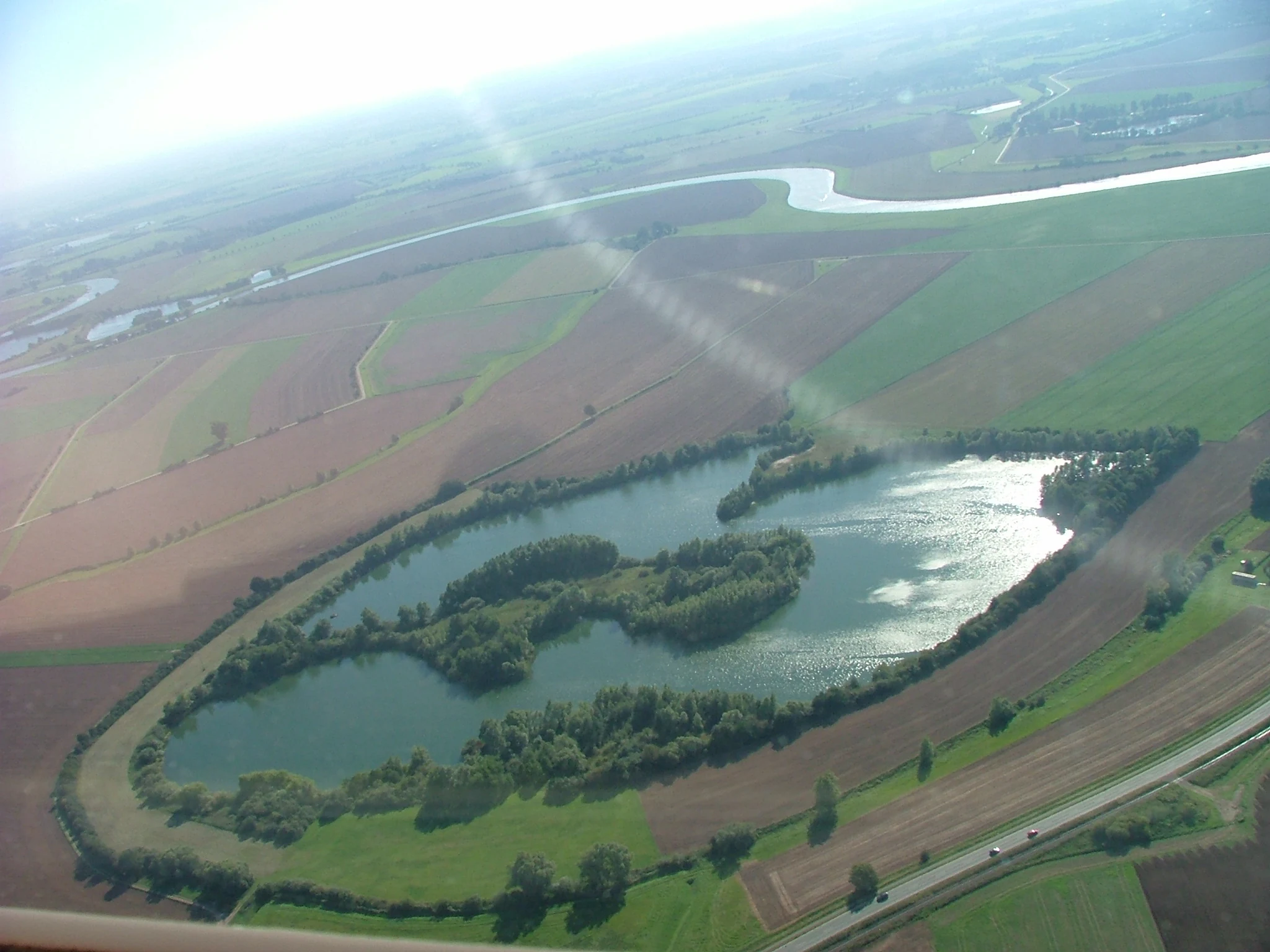
An aerial view of the Wiedesee, an elongated lake with wooded islands, surrounded by farmland and a nearby river.
Aerial view of the Wiedesee nature reserve surrounded by agricultural land in Lower Saxony, Germany.

Wiedesee history and protected-area timeline

The Wiedesee originated as a quarrying pond, formed through gravel or sand extraction typical of the post-war and late twentieth-century landscape intervention in the Weser lowlands. Its transformation from a working extraction site to a protected natural area was formalized on 23 August 1984, when the lake and its surrounding margins were designated as a nature reserve under the code NSG HA 076. The designation was made under the responsibility of the Landkreis Nienburg/Weser as the lower nature protection authority.

Since its designation, the site has been actively managed rather than simply left untouched. The Nienburg district chapter of the Naturschutzbund Deutschland took on stewardship of the area and introduced specific measures aimed at supporting vulnerable bird species. The most notable of these was the anchoring of a floating raft on the lake to act as an artificial breeding island for common terns, addressing the loss of natural nesting sites elsewhere in the region. Over the decades, the reserve has come to function as both a wintering and staging site for migratory waterbirds and a managed breeding site for water-associated species.

Wiedesee landscape and geographic character

The landscape of the Wiedesee reserve is defined by its contrast between the lake and the surrounding farmland. The lake occupies roughly 15 hectares of open water in a relatively flat setting at around 15 meters above sea level, with a length of approximately 620 meters. The terrain is gentle and low-lying, characteristic of the lower Weser valley margins, with no significant relief but a meaningful vertical layering between water surface, reed zones, wet meadows, and the surrounding cultivated land.

The visible structure of the site forms concentric bands. The open water in the center gives way to reed belts that fringe much of the shoreline, which in turn transition into wet meadow margins before reaching the dry agricultural fields that completely encircle the reserve. This zonation, although compressed in scale, gives the area a layered character similar to that of larger lake reserves. The view from the surrounding countryside is marked by the sudden appearance of water, reeds, and tall meadow vegetation amid an otherwise open and uniform agricultural mosaic, making the site visually distinctive despite its modest size.

Wiedesee ecosystems, habitats, and plant life

Ecologically, the Wiedesee is shaped by the interplay between its open water, reed zones, and wet meadow margins. The reed belts along the shore are a key habitat element, providing cover, nesting sites, and feeding grounds for a range of water-associated species. The transition from reed to wet meadow supports a different set of conditions, with damp grassland flora and the invertebrates that depend on it. Together, these zones create a layered ecosystem that is unusually rich for such a small area.

The surrounding agricultural land presses directly against the reserve boundary, with no buffer of woodland or scrub, which makes the internal habitat gradient of the Wiedesee all the more important. Water quality and the persistence of reed and meadow habitats are closely linked to the reserve's protected status and to active management by the local NABU chapter. The site functions as a small but resilient node within the broader ecological network of the Weser lowlands, where larger wetlands have largely been lost to drainage and conversion.

Wiedesee wildlife and species highlights

The wildlife significance of the Wiedesee centers on its birdlife. The lake and its reed-fringed margins serve as a staging area for migratory waterbirds and as a wintering site, offering open water and undisturbed shoreline habitat in an otherwise intensively farmed landscape. Common species associated with such habitats in the Weser region include ducks, coots, grebes, and a range of other waterfowl, all of which use the site during passage or in the colder months.

The site is particularly notable for its breeding bird interest. The floating raft anchored on the lake by the Nienburg NABU chapter was specifically installed to support common terns, a species whose natural nesting sites along rivers and on open shores have declined sharply in northern Germany. By providing a predator-safe artificial island, the reserve has created a small but functioning breeding refuge for the species. Beyond birds, the reed zones and wet meadows also support a range of typical wetland invertebrates and amphibians, contributing to the overall habitat value of the reserve.

Wiedesee conservation status and protection priorities

From a conservation perspective, the Wiedesee matters less for its size than for its function as a protected habitat island in an intensively used agricultural landscape. The designation of the lake and its margins as a nature reserve in 1984 ensured legal protection of the open water, reed belts, and wet meadows against drainage, conversion, or damaging shoreline use. The 26-hectare reserve represents a deliberate preservation of ecological complexity in a region where most natural wetlands have already been lost or degraded.

The active involvement of the Naturschutzbund Deutschland adds a practical conservation dimension. The installation and maintenance of the floating breeding raft for common terns demonstrates targeted intervention to compensate for habitat loss elsewhere in the region. The reserve also contributes to broader conservation goals by supporting migratory waterbirds, providing a stepping stone within the wider Weser lowland network, and preserving reed and meadow habitats that are otherwise increasingly rare in this part of Lower Saxony. Its long-term value lies in being a stable, managed refuge rather than a large wilderness area.

Wiedesee cultural meaning and human context

The Wiedesee has limited cultural or historical framing as a landmark, with its identity shaped almost entirely by ecological and conservation significance rather than long-standing settlement or folklore. Its origin as a quarrying pond ties it to the broader post-war history of land modification in the Weser lowlands, where gravel and sand extraction reshaped many small areas of countryside and left behind waterbodies that were later re-evaluated for their natural value. Today the lake is primarily understood locally as a small nature reserve and a quiet walking destination rather than as a site of traditional or cultural importance.

Top sights and standout views in Wiedesee

The Wiedesee's strongest distinguishing features are its compact habitat mosaic, its role as a protected waterbird refuge in an agricultural setting, and its actively managed breeding raft for common terns. As a 26-hectare reserve built around a modest former quarrying pond, it packs open water, reed zones, and wet meadows into a small footprint, creating disproportionate ecological value. Its combination of formal protection, long-term NABU stewardship, and specific habitat interventions makes it an unusually complete example of small-scale protected-area conservation in Lower Saxony.

Best time to visit Wiedesee

The Wiedesee is an all-year site, but the feel of a visit shifts with the seasons. Spring and early summer bring the most active birdlife, with common terns using the breeding raft and other waterbirds settling around the reed edges. Summer offers the fullest expression of the reed belts and wet meadows, with the surrounding fields in active cultivation creating a sharp visual contrast against the reserve. Autumn and winter are the strongest periods for waterbird interest, as migratory and wintering waterfowl concentrate on the open water and the site becomes quieter and more contemplative.

Monthly climate preview

Track monthly temperature variations and precipitation averages across the protected park landscape.

Wiedesee Climate Normals and Long Term Temperature and Precipitation Patterns

Representative coordinate records show measured monthly temperature ranges and precipitation averages spanning the entire annual cycle at Wiedesee. Examining the complete twelve month profile provides deeper baseline context for long term climatic conditions at this location.
Annual mean9 °C
1 °C18 °C
Jan
Feb
Mar
Apr
May13°
Jun16°
Jul18°
Aug18°
Sep14°
Oct
Nov
Dec
Warmest month
July

18.1 °C

Coolest month
January

0.7 °C

Wettest month
July

2.5 mm/day

Driest month
April

1.4 mm/day

Park location guide

Geography guide, regional context, and park location map for Wiedesee

Wiedesee park geography, regions, and map view in Germany

Understand where Wiedesee sits in Germany through a broader geographic reading of the surrounding landscape, nearby location context, and its mapped position within the national park landscape.

How Wiedesee fits into Germany

Germany is a federal republic in Western and Central Europe with a population of over 83 million across sixteen constituent states. It is Europe's largest economy by nominal GDP and a major global exporter and importer. The capital is Berlin, and the country borders Denmark, Poland, Czech Republic, Austria, Switzerland, France, Luxembourg, Belgium, and the Netherlands.

Wider geography shaping Wiedesee in Germany

Germany is located in Western and Central Europe, spanning 357,022 km². It borders Denmark to the north, Poland and the Czech Republic to the east, Austria and Switzerland to the south, and France, Luxembourg, Belgium, and the Netherlands to the west. The country has coastlines on the Baltic Sea and North Sea to the north, with the Alps located in the southern region.

Map view of Wiedesee

Use this park location map to pinpoint Wiedesee in Germany, understand its exact geographic position, and read its mapped placement within the surrounding landscape more clearly.

Pigeon | © OpenStreetMap contributors

Location context for Wiedesee

Lower Saxony

Explore the open water, reed belts, and wet meadow habitats defining this protected reserve.

Wiedesee Photos and Landscape Scenery: Visualizing the Protected Nature Reserve

Visual records illustrate the distinct concentric zones of open water, reed beds, and wet meadows that characterize the Wiedesee nature reserve. Examining these protected habitats provides clearer insight into the ecological character of a compact waterbird refuge surrounded by Lower Saxony farmland.

An aerial view of the Wiedesee, an elongated lake with wooded islands, surrounded by farmland and a nearby river.

Park atlas

Compare nearby nature reserves and regional wetland habitats across Lower Saxony

Explore Parks Near Wiedesee and Surrounding Protected Landscapes

Browse other protected areas near Wiedesee to examine similar wetland reserves and lowland habitats throughout the surrounding region. Comparing adjacent nature reserves reveals broader ecological patterns across the agricultural mosaic of the Middle Weser valley.
Nature reserveLandkreis Nienburg/Weser
About 17 km away#1 closest

Southeast

Weißer Graben Nature Reserve: Mapped Protected Landscapes in Landkreis Nienburg/Weser

Peatland regeneration and meadow bird habitat boundaries

Located within the flat terrain of the northern German lowlands, Weißer Graben serves as a prime example of successful peatland renaturation and wet grassland management. The site structure contrasts recovering industrial peat cuttings with intact birch swamp forests and varied meadow patterns. This entry provides geographic context on the reserve boundaries, the role of local waterways in hydrologic maintenance, and its placement within the larger Lichtenmoor complex.

Area
5.02 km²
Established
1995
IUCN
IV
Nature reserveLower Saxony
About 20 km away#2 closest

Northwest

Wachendorfer/Gödestorfer Bruch Nature Reserve and Protected Wetland Landscape in Lower Saxony

Wetland geography and forest conservation in the Diepholz district

Wachendorfer/Gödestorfer Bruch provides a clear view into the transitional wetland ecosystems of Lower Saxony. The nature reserve features a complex of wet woodland and grassland habitats that highlight the hydrological diversity of the Diepholz district, offering significant insight into regional forest conservation and land management.

Area
1.95 km²
Established
2000
IUCN
IV
Relief
Lowland
Nature reserveNiedersachsen
About 21 km away#3 closest

North

Waller Flachteiche Nature Reserve: Exploring the Geography of Protected Landscapes in Niedersachsen

Mapped habitats of a former sand quarry wetland

Waller Flachteiche is a state-recognized nature reserve covering over 22 hectares of sandy, lowland terrain in Germany. The protected area offers a look at a recovered industrial site, where periodically drying ponds and diverse scrubland create a specialized habitat for rare amphibians and wetland flora. Its defined boundaries highlight a critical Natura 2000 component within the broader Niedersachsen region.

Area
0.227 km²
Established
2018
IUCN
IV
Nature reserveLower Saxony
About 22 km away#4 closest

Northeast

Verdener Moor Nature Reserve: Geographic Atlas and Protected Area Context

Preserving raised bog ecosystems in Lower Saxony, Germany

Located in the municipality of Kirchlinteln, Verdener Moor functions as a protected nature reserve that demonstrates lowland peatland conservation. The landscape features a distinct mosaic of open water resulting from historical peat extraction, wet heath, and rewilded forest edges. This site offers valuable insight into the restoration of bog habitats through rewetting and bush removal within the broader geography of Lower Saxony.

Area
0.91 km²
Established
1989
IUCN
IV
Relief
Lowland
Nature reserveLower Saxony
About 24 km away#5 closest

Northeast

Wedeholz Nature Reserve: Geographic Overview of Lower Saxony Protected Forest Landscapes

Ancient oak forests, Geest terrain, and protected wetland habitats

Wedeholz represents a dense forest conservation area in Lower Saxony, defined by its mature oak and beech communities. The reserve terrain transitions from dry sandy Geest soils to delicate pine swamp forests and floating bogs, supporting a high density of deadwood-dependent species and woodland biodiversity within a compact, protected boundary.

Area
1.83 km²
Established
2019
IUCN
IV
Relief
Upland
Nature reserveLower Saxony
About 25 km away#6 closest

North

Waller Moor Nature Reserve: Geographic Context and Protected Landscape Profile

Mapping raised bog restoration in the Verden district of Lower Saxony

Waller Moor represents a focused effort to restore degraded peatland within Lower Saxony. By integrating grassland buffers and small pond habitats, the reserve preserves a specific lowland bog character. Its placement near the Spanger Holz woodland highlights the interplay between protected core habitats and managed regional terrain in northern Germany.

Area
0.25 km²
Established
1985
IUCN
IV
Relief
Lowland
Nature reserveNienburg/Weser
About 26 km away#7 closest

South

Wellier Schleife/Staustufe Landesbergen: A Protected River Oxbow and Floodplain Geography

Mapping protected habitats in the Middle Weser valley of Germany.

This nature reserve protects the Wellier Schleife, a significant oxbow arm created by the Landesbergen weir. The 278-hectare area encompasses former gravel pits, wetland fringes, and agricultural floodplains. It stands as a vital component of the Wesertalaue bei Landesbergen bird protection network, reflecting the interplay between river engineering and conservation efforts.

Area
2.78 km²
Established
1996
IUCN
IV
Relief
Lowland
Nature reserveLower Saxony
About 26 km away#8 closest

Northeast

Wolfsgrund Nature Reserve: Geographic Overview of Protected Heathlands in Lower Saxony

Inland dune topography and alder swamp forest ecology

Wolfsgrund represents a core protected area in Lower Saxony, defined by its unique inland dune geography and the narrow valley of the Everser Bach. The reserve encompasses a diverse ecological gradient, protecting sensitive dry heath, moist heathlands, and alder swamp forests that serve as a crucial refuge for regional biodiversity. This structured geographic overview highlights the terrain transitions and conservation significance of this essential German nature reserve.

Area
0.458 km²
Established
1977
IUCN
IV

Common questions about visiting, size, designation, and location context for Wiedesee

Wiedesee FAQs for park facts, access, geography, and protected area context

Find quick answers about Wiedesee, including protected-area facts, park geography, trail and visitor context, and how the park fits into its surrounding country and regional landscape.
MoriAtlas Explorer

Continue Your Protected Areas Search Across the Global Atlas

Deepen your exploration by continuing the structured search for national parks and protected areas worldwide. Utilize the comprehensive filtering capabilities to compare different conservation landscapes and refine your understanding of global park geography. Discover more about the distribution and characteristics of protected natural areas.

Global natural geography