
Mori Atlas logo
Nature reserveWilhelmsthaler und Haller Bachtal

Discover the geographic landscape, valley stream systems, and habitat mosaics of this Remscheid nature reserve.

Wilhelmsthaler und Haller Bachtal: A Protected Nature Reserve in the Bergisches Land of Germany

(Naturschutzgebiet Wilhelmsthaler und Haller Bachtal)

Wilhelmsthaler und Haller Bachtal encompasses a protected mosaic of nutrient-poor meadows, stream-side habitats, and wet woodlands within the hilly terrain of the Bergisches Land in North Rhine-Westphalia. This nature reserve serves as a vital ecological corridor in the Remscheid region, where the Hallebeeke and Wilhelmsthaler Bach create an interweaving of valley floors and ridges. The site showcases how traditional land management sustains a dense concentration of rare meadow flora and aquatic species in a compact, undulating landscape.

nature reservestream valleygrasslandnutrient-poor meadowhedgerowswoodland
A flat-style digital illustration of a valley landscape, featuring green meadows, stylized trees, a wooden fence, and steep pinkish cliffs under a pale sky.

Wilhelmsthaler und Haller Bachtal

Nature reserve

Park overview

Structured park overview, official facts, and landscape profile for Wilhelmsthaler und Haller Bachtal

Wilhelmsthaler und Haller Bachtal park facts, protected area profile, and essential visitor context

Review the core facts for Wilhelmsthaler und Haller Bachtal, including designation, size, terrain, visitor scale, habitats, and operating context in one park-focused overview.

About Wilhelmsthaler und Haller Bachtal

Wilhelmsthaler und Haller Bachtal is a compact nature reserve in the German state of North Rhine-Westphalia, located on the edge of the city of Remscheid in the Bergisches Land region. The protected area lies east of the Hackenberg district and circles the small rural settlement of Halle, following the narrow valleys of two brooks whose waters ultimately join the River Wupper.

The reserve is small in size but rich in landscape variety. Its two valleys, the Haller Bachtal drained by the Hallebeeke and the Wilhelmsthaler Bach valley, carry the stream between meadows, hedgerows, woodland patches, and small ponds. The terrain rises from around 260 metres to about 310 metres above sea level, shaping the local climate and supporting a mix of wetter lowland habitats and drier upland grasslands.

Ecologically, the area is valued for the way in which many rare and declining habitat types meet within a limited space. Species-rich nutrient-poor meadows, structurally rich hedgerows, wet woodland edges, brooks, and ponds with diverse aquatic vegetation all occur in close proximity. This combination gives the reserve both high conservation significance and considerable landscape-aesthetic value, and sets it apart as one of the more distinctive small protected areas in Remscheid's network of stream-valley reserves.

Quick facts and research context for Wilhelmsthaler und Haller Bachtal

Wilhelmsthaler und Haller Bachtal is a nature reserve (Naturschutzgebiet) of about 10 hectares in the city of Remscheid, North Rhine-Westphalia. It lies between 260 and 310 metres above sea level and has been protected since 2003 under the official code RS-016. The reserve is part of the Remscheid landscape plan and is administered by the local landscape authority.

The area encompasses two valleys: the Haller Bachtal, containing the Hallebeeke brook, and the Wilhelmsthaler Bach valley, whose waters ultimately join the River Wupper. Within these valleys, species-rich meadows, hedges, ponds, and brook-side habitats form a rare ecological mosaic. The reserve is classified under IUCN Category IV as a Habitat/Species Management Area and is recognised in the World Database on Protected Areas under WDPA ID 319336.

Protection and recognition

Examine documented terrestrial boundaries, management scope, and verified registry records.

Wilhelmsthaler und Haller Bachtal Protection Status and Protected Area Recognition

Wilhelmsthaler und Haller Bachtal maintains a recorded terrestrial protection scope within international protected area databases. Reviewers can examine the official designation framework and verified registry entries associated with this conservation landscape.

Protection details

Protection scope
Terrestrial
Transboundary protection
No
WDPA ID
319336
Park context

Deeper park guide and search-rich context for Wilhelmsthaler und Haller Bachtal

Wilhelmsthaler und Haller Bachtal history, landscape, wildlife, and travel context

Explore Wilhelmsthaler und Haller Bachtal through its history, landscape character, ecosystems, wildlife, conservation priorities, cultural context, and seasonal travel timing in a structured park guide built for atlas discovery and search intent.

Why Wilhelmsthaler und Haller Bachtal stands out

The reserve is best known for the dense concentration of rare habitats and species found within a small area, and is often described as offering one of the most species- and flower-rich nutrient-poor meadows in the Remscheid area. Its Haller Bachtal grasslands in particular harbour a striking assemblage of endangered meadow plants that depend on low-intensity traditional management. Beyond the meadows, the reserve is notable for its stream-side habitats along the Hallebeeke and the Wilhelmsthaler Bach, including ponds with diverse floating-leaf, reed, and underwater vegetation. Together these elements make the area a textbook example of how small valley landscapes of the Bergisches Land can combine cultural, scenic, and ecological value.
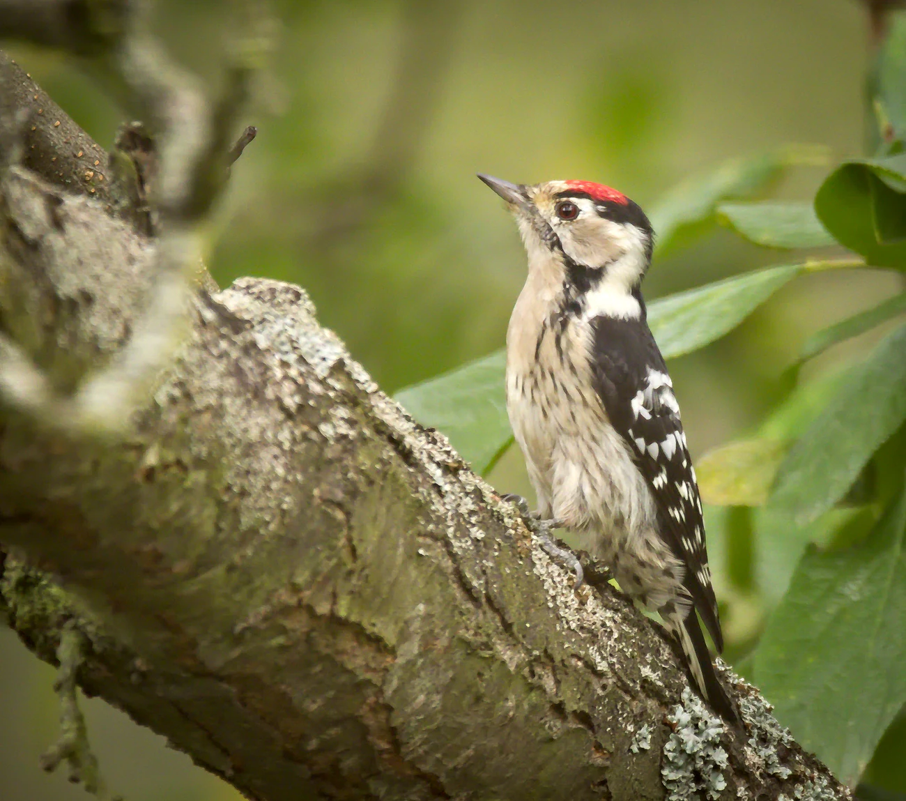
A small male lesser spotted woodpecker with a distinctive red crown and black and white patterned feathers perched on a weathered, mossy tree branch, looking upwards.
A male lesser spotted woodpecker perched on a mossy branch.

Wilhelmsthaler und Haller Bachtal history and protected-area timeline

The reserve was formally designated as a Naturschutzgebiet in 2003 under the official identifier RS-016, following a process tied to the Remscheid landscape plan. Its establishment built on growing awareness of the ecological importance of the small Bach valleys around Halle and the Wilhelmsthaler Bach, which had already been recognised in regional planning inventories.

Management responsibilities sit with the lower landscape authority (Untere Landschaftsbehörde) of the city of Remscheid, reflecting the fact that the reserve lies entirely within Remscheid's municipal territory. The designation as an IUCN Category IV area confirms its role as a habitat and species management area, in which active measures are used to maintain the traditional meadow, hedgerow, and pond habitats that depend on continued low-intensity human management.

Although the protected legal status is comparatively recent, the cultural landscape the reserve protects is much older. The meadows, hedgerows, and ponds that characterise the valley are products of long-standing agricultural use, and their survival reflects decades of relatively modest land-use pressure. Designation in 2003 represented a formal recognition that these traditional valley landscapes, rather than being replaceable by modern land use, are themselves the object of conservation.

Wilhelmsthaler und Haller Bachtal landscape and geographic character

The landscape of Wilhelmsthaler und Haller Bachtal is shaped by two narrow, shallow stream valleys cutting through the upland terrain of the Bergisches Land. The Hallebeeke runs through the Haller Bachtal on the southern edge of Halle before turning east, while the Wilhelmsthaler Bach sweeps around the north and east sides of the same settlement, eventually descending to the River Wupper near the small locality of Wilhelmstal.

Within these valleys the topography is gentle but varied. Elevations range roughly between 260 and 310 metres above sea level, producing a mosaic of valley floor, slope, and ridge conditions in a very small area. This subtle but persistent relief supports a patchwork of habitats that change quickly over short distances, including damp meadow depressions, drier slopes, and brooks flanked by wet woodland.

Beyond the immediate valleys, the wider setting is typical of the Bergisches Land: a gently undulating landscape of small woodland patches, dispersed farmsteads, and traditional meadows. The reserve fits into this larger cultural landscape as a particularly well-preserved pocket, where the combination of small-scale relief, persistent traditional land use, and intact stream systems has produced a scenery of considerable visual and ecological richness.
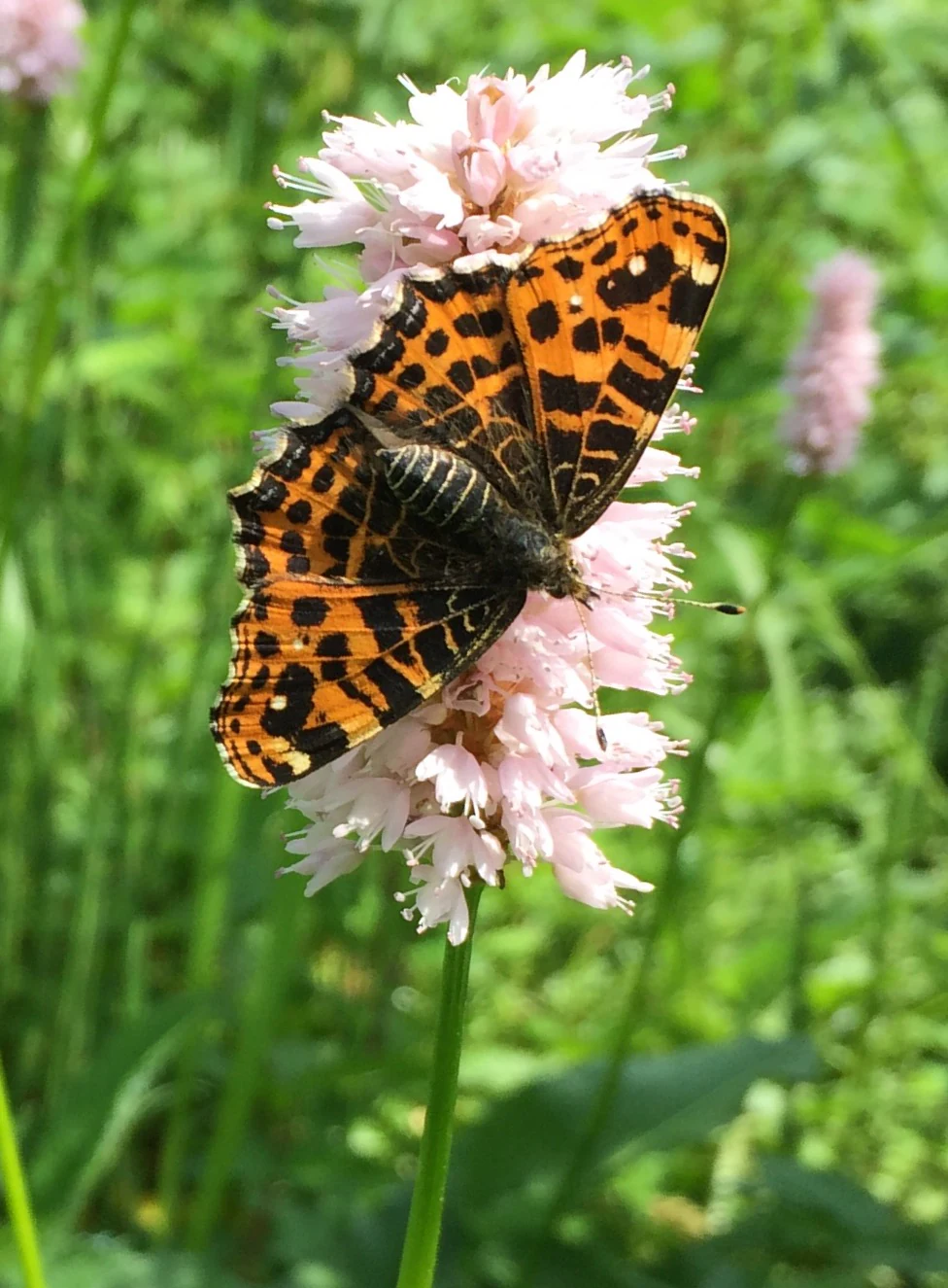
An orange and black patterned Map butterfly with its wings spread, resting on a cluster of small, pale pink cylindrical flowers.
A Map butterfly (Araschnia levana) resting on a common bistort flower.

Wilhelmsthaler und Haller Bachtal ecosystems, habitats, and plant life

The reserve's ecological profile is defined by the unusually close interlocking of several habitat types within a compact area. Mature meadows form the most conspicuous element, especially in the middle section of the Haller Bachtal, which is home to some of the most species- and flower-rich nutrient-poor grasslands in the entire Remscheid area. Here, traditional mowing and grazing practices have preserved a dense flora of herbaceous plants that have become rare elsewhere in the region.

Woodland and shrub habitats are equally important. Hedgerows structure the Haller Bachtal, dividing the meadow land into smaller parcels that maintain ecological continuity and shelter wildlife along the valley. In the Wilhelmsthaler Bachtal east of Böhlefeld, ecologically valuable field margins add another layer of semi-open habitat. These linear elements are critical as landscape-connecting features, linking forest patches, meadows, and brooks into a functional ecological network.

The aquatic and wet habitats complete the picture. South of Böhlefeld on the Wilhelmsthaler Bach and south of Halle, small ponds support a notably diverse community of floating-leaf plants, reeds, and submerged aquatic vegetation. Combined with the brooks themselves, these features create a wetland gradient from open water through marshy edges to wet meadow and finally to drier grassland and woodland, all within the bounds of the protected area.
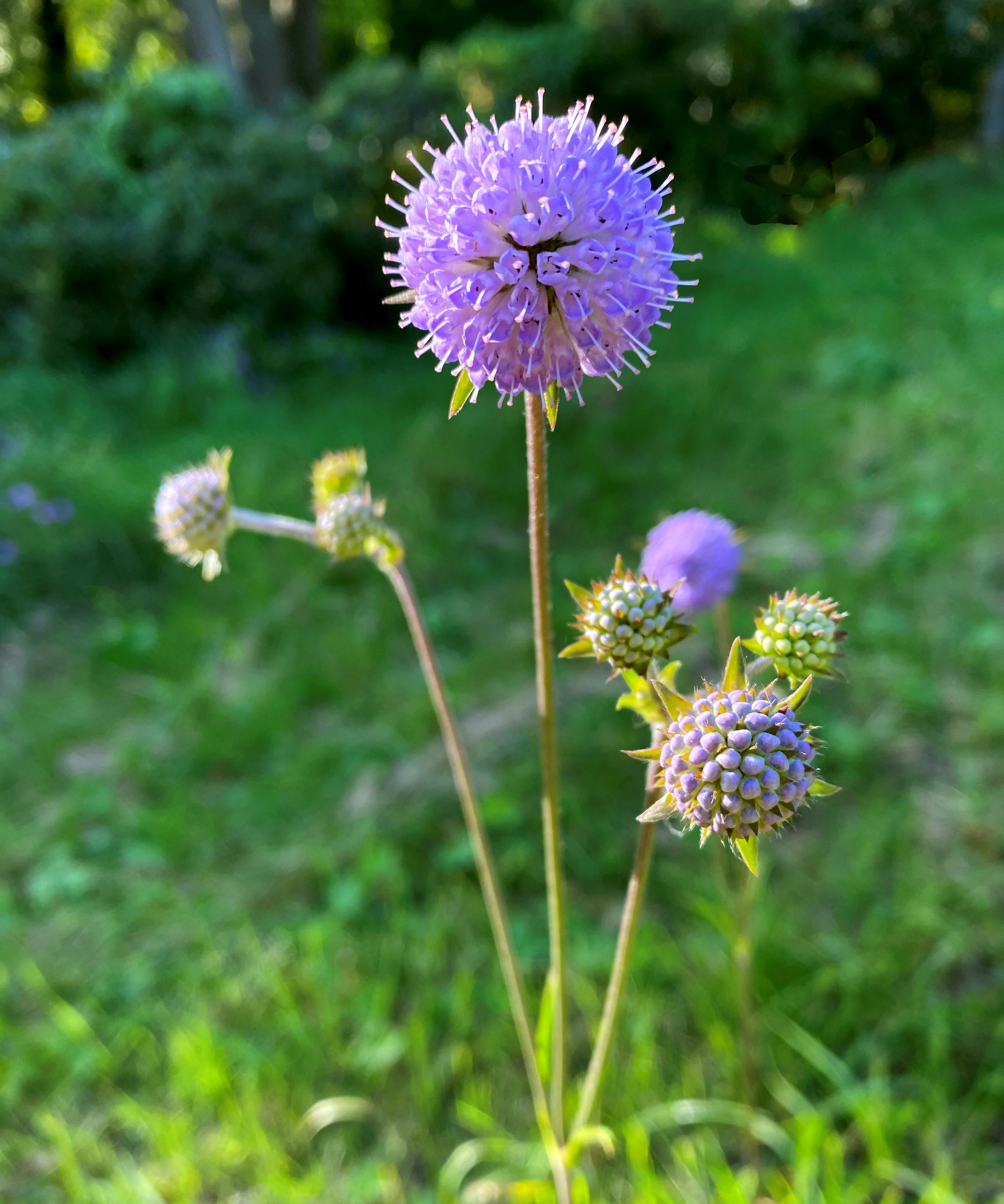
A close up view of several purple globe-shaped flower heads of a Succisa pratensis plant growing in a grassy meadow.
A flowering Devil's bit scabious (Succisa pratensis) in the Wilhelmsthaler und Haller Bachtal nature reserve.

Wilhelmsthaler und Haller Bachtal wildlife and species highlights

The diverse habitats of Wilhelmsthaler und Haller Bachtal support a wide range of animal species, several of which are considered endangered regionally. The brooks and ponds provide habitat for fish such as the Groppe (Cottus gobio), a small freshwater species that depends on clean, well-oxygenated streams and is a classic indicator of healthy small valley waters in the Bergisches Land.

Birdlife is particularly rich for such a small area. Stream-side species like the Wasseramsel (White-throated Dipper) and various woodland-dependent birds make use of the wet valley habitats, while more open-country species occur in the meadows and field margins. Notable breeding and visiting species recorded in the reserve include the Gartenrotschwanz (Common Redstart), Trauerschnäpper (European Pied Flycatcher), Sperber (Eurasian Sparrowhawk), Habicht (Northern Goshawk), and Baumfalke (Eurasian Hobby). Two woodpecker species, the Kleinspecht (Lesser Spotted Woodpecker) and the Schwarzspecht (Black Woodpecker), indicate the presence of mature, structurally rich woodland.

The butterfly community adds further ecological interest on the warm meadow slopes. The Landkärtchen (Map Butterfly) has been observed on Schlangen-Knöterich (Bistort), a plant typical of damp meadows, pointing to the role of the reserve as habitat for invertebrates as well as vertebrates. Together these groups illustrate how the small-scale mosaic of meadows, hedgerows, woodland, and water supports a disproportionately diverse and ecologically meaningful animal community.
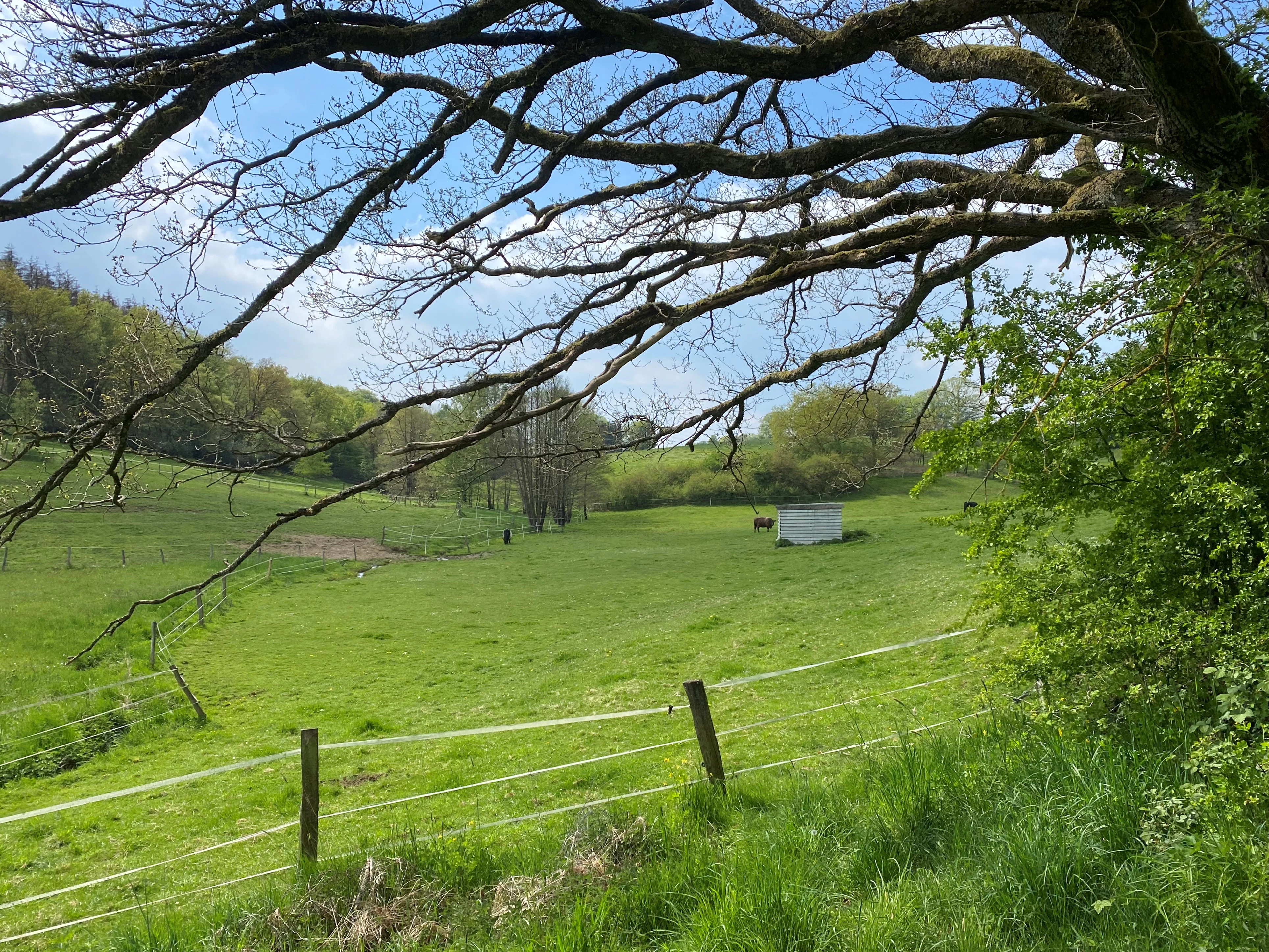
A wide, grassy, rolling valley landscape with a small shed and a wire fence in the foreground, viewed beneath the sprawling branches of a large tree.
A view of the pasture and meadow landscape within the Wilhelmsthaler und Haller Bachtal nature reserve.

Wilhelmsthaler und Haller Bachtal conservation status and protection priorities

From a conservation perspective, the reserve's significance lies in the persistence, within a small footprint, of habitat types that have declined sharply elsewhere in the region. Its nutrient-poor meadows, in particular, are among the most endangered semi-natural habitats in North Rhine-Westphalia; their survival depends on continued low-intensity management and is therefore an active conservation priority.

The reserve also plays an important role as a connecting element within the broader protected-area network of Remscheid. Its hedgerows, field margins, and stream corridors function as stepping stones and corridors that link other nature reserves in the city, helping maintain ecological processes such as species movement, pollination, and nutrient cycling across a wider working landscape than the reserve alone.

Designation as an IUCN Category IV Habitat/Species Management Area reflects this active, intervention-based conservation approach. Rather than being left to develop freely, the reserve is managed to maintain and, where needed, restore the traditional meadow, hedgerow, pond, and brook habitats on which many of its rare species depend. The inclusion of the area in the World Database on Protected Areas underscores its recognition beyond the local level.

Wilhelmsthaler und Haller Bachtal cultural meaning and human context

The cultural dimension of the reserve is rooted in the traditional rural landscape of the Bergisches Land. The meadows, hedgerows, field margins, and ponds that characterise the protected area are products of centuries of small-scale agricultural management, in which meadows were mown for hay and grazed at low intensity, hedgerows were maintained as boundaries and wind protection, and small ponds served practical farm purposes.

The settlement geography around the reserve reflects this long human presence. Halle, Böhlefeld, and Wilhelmstal are small historic farming hamlets, and their continued existence has contributed to the survival of the open and semi-open habitats in the valleys. The very fact that the reserve's biodiversity depends on these cultural practices makes the area a striking example of how biodiversity and traditional land use can reinforce each other in the German uplands.

Top sights and standout views in Wilhelmsthaler und Haller Bachtal

The most distinctive highlights of Wilhelmsthaler und Haller Bachtal are its exceptionally species-rich nutrient-poor meadows in the middle Haller Bachtal and its tightly woven mosaic of meadows, hedgerows, ponds, and brook habitats in a remarkably small area. The reserve is also notable for its population of endangered meadow plants such as Blutwurz, Sumpfpippau, Kammgras, Sumpf-Schafgarbe, Teufelsabbiss, and Schwarze Flockenblume, and for stream-side species including the Wasseramsel and Groppe.

Equally important is its function as a connecting node within the Remscheid nature reserve network, where hedgerows and field margins sustain ecological links between forest, grassland, and water across the wider Bergisches Land landscape.

Best time to visit Wilhelmsthaler und Haller Bachtal

Late spring through early summer is generally the most rewarding window for visiting nature reserves of this type, when species-rich meadows reach their peak flowering and butterflies such as the Landkärtchen become active along the field margins. Early morning in this period offers the best chances of observing woodland and stream-side birds, including woodpeckers, dippers, and small raptors.

Late summer and early autumn bring a different atmosphere, with taller herbaceous vegetation, ripening seeds, and increased activity around the ponds and brook margins. Because the reserve is essentially a working cultural landscape, visitors should be prepared for damp meadow ground and should stick to existing paths to avoid disturbing the very habitats they have come to see. Conditions remain mild through much of the year in the sheltered Bergisches Land valleys, but winter offers fewer ecological highlights and shorter daylight for observation.


Monthly climate preview

Representative long term temperature and precipitation measurements across twelve monthly periods

Wilhelmsthaler und Haller Bachtal Climate Normals and Annual Weather Patterns

Representative coordinate records show average temperatures ranging from near freezing to warm mid year highs alongside consistent daily precipitation throughout the annual cycle. Detailed monthly climate data reveals complete long term temperature ranges and precipitation normals across the entire park landscape.
Annual mean9 °C
0 °C18 °C
Jan
Feb
Mar
Apr
May13°
Jun16°
Jul18°
Aug18°
Sep14°
Oct
Nov
Dec
Warmest month
July

18.3 °C

Coolest month
January

0.3 °C

Wettest month
December

3 mm/day

Driest month
April

1.8 mm/day

Park location guide

Geography guide, regional context, and park location map for Wilhelmsthaler und Haller Bachtal

Wilhelmsthaler und Haller Bachtal park geography, regions, and map view in Germany

Understand where Wilhelmsthaler und Haller Bachtal sits in Germany through a broader geographic reading of the surrounding landscape, nearby location context, and its mapped position within the national park landscape.

How Wilhelmsthaler und Haller Bachtal fits into Germany

Germany is a federal republic in Western and Central Europe with a population of over 83 million across sixteen constituent states. It is Europe's largest economy by nominal GDP and a major global exporter and importer. The capital is Berlin, and the country borders Denmark, Poland, Czech Republic, Austria, Switzerland, France, Luxembourg, Belgium, and the Netherlands.

Wider geography shaping Wilhelmsthaler und Haller Bachtal in Germany

Germany is located in Western and Central Europe, spanning 357,022 km². It borders Denmark to the north, Poland and the Czech Republic to the east, Austria and Switzerland to the south, and France, Luxembourg, Belgium, and the Netherlands to the west. The country has coastlines on the Baltic Sea and North Sea to the north, with the Alps located in the southern region.

Map view of Wilhelmsthaler und Haller Bachtal

Use this park location map to pinpoint Wilhelmsthaler und Haller Bachtal in Germany, understand its exact geographic position, and read its mapped placement within the surrounding landscape more clearly.

Pigeon | © OpenStreetMap contributors

Location context for Wilhelmsthaler und Haller Bachtal

Nordrhein-Westfalen

Visualizing the stream valleys, protected meadows, and habitats of the Bergisches Land

Wilhelmsthaler und Haller Bachtal Photos and Landscape Scenery

Photographic documentation reveals the intricate mosaic of valley streams, wet woodlands, and wildflower meadows that define the protected terrain of Wilhelmsthaler und Haller Bachtal. Visual exploration provides clear insight into the ecological character and small-scale landscape features shaping this German nature reserve.

A small male lesser spotted woodpecker with a distinctive red crown and black and white patterned feathers perched on a weathered, mossy tree branch, looking upwards.

A white-throated dipper bird with dark brown plumage and a white chest standing on a wet, mossy rock in a stream, carrying a small insect in its beak.

An orange and black patterned Map butterfly with its wings spread, resting on a cluster of small, pale pink cylindrical flowers.

A close up view of several purple globe-shaped flower heads of a Succisa pratensis plant growing in a grassy meadow.

A wide, grassy, rolling valley landscape with a small shed and a wire fence in the foreground, viewed beneath the sprawling branches of a large tree.

A green, grassy meadow stretch narrowing into a distance, surrounded by thick deciduous trees with fresh spring foliage under a partly cloudy blue sky.

Park atlas

Compare adjacent stream valleys and regional reserves across the Bergisches Land

Parks Near Wilhelmsthaler und Haller Bachtal and Surrounding Protected Landscapes

Browse nearby protected areas and nature reserves situated throughout the surrounding Remscheid uplands and stream valley network. Comparing these connected landscapes reveals how regional topography and traditional land use shape local habitats.
Nature reserveOberbergischer Kreis
About 1.2 km away#1 closest

East

Wupper bei Radevormwald: Protected River Valley and Riparian Woodland Geography

Nature reserve landscape in the Oberbergischer Kreis region

Wupper bei Radevormwald serves as a critical protected area within the Wupper river corridor, featuring a mosaic of beech-oak forests and floodplain alder stands. The reserve highlights the contrast between calm, impounded reaches and energetic, meandering water sections, providing an essential study of river valley morphology and natural recovery in the Bergisches Land.

Area
1.208 km²
Established
2003
IUCN
IV
Relief
Upland
A horizontal watercolor painting depicting a meandering stream flowing through open, green, and pink-toned marshy grasslands bordered by a distant treeline.
Nature reserveNordrhein-Westfalen
About 4.6 km away#2 closest

Northeast

Spreeler Bachtal Nature Reserve: Geography and Protected Valley Landscapes

An upland nature reserve in the Bergisches Land region of Germany.

This nature reserve centers on the meandering Spreeler Bach, a gravel-bedded stream defining a diverse protected area in North Rhine-Westphalia. The terrain includes wet meadows, spring-fed grassland, and managed deciduous forests on steeply rising valley slopes. It serves as a prime example of targeted habitat conservation within the larger slate landscapes of the Bergisches Land, straddling administrative boundaries between Radevormwald and Ennepetal.

Area
0.21 km²
Established
2019
IUCN
IV
A soft watercolor illustration of a green valley with a central stream or river winding through meadows towards distant hills.
Nature reserveOberbergischer Kreis
About 5.6 km away#3 closest

Southeast

Leiverbachtal und Talhänge: Protected Stream Valley and Forest Habitat in Oberbergischer Kreis

Examining the geography of a Bergisches Land nature reserve

Leiverbachtal und Talhänge stands as a significant nature reserve within the Oberbergischer Kreis, defined by its near-natural meandering stream and diverse riparian ecosystem. The site offers a detailed look at floodplain meadows, slope forest transitions, and the ongoing shift toward broadleaf woodland within the German Mittelgebirg landscape.

Area
0.92 km²
Established
2006
IUCN
IV
Relief
Upland
A wide watercolor illustration showing a winding river flowing through a green valley with pink and purple flowers in the foreground and soft yellow hills in the background.
Nature reserveNordrhein-Westfalen
About 5.6 km away#4 closest

West

Leyerbachtal Nature Reserve: A Protected Valley and Industrial Heritage Site in Remscheid

An alluvial landscape and low-mountain stream corridor in Germany

Leyerbachtal serves as a vital protected corridor featuring a meandering brook, expansive gravel banks, and species-rich wet meadows. Located in the heart of the Bergisches Land, this nature reserve integrates high-value ecological habitats with the historic industrial remnants of Remscheid's water-powered past.

Area
0.151 km²
Established
2003
IUCN
IV
Watercolor painting of a rolling rural landscape with distant purple hills, green meadows, and trees, with a soft yellow sky.
Nature reserveNordrhein-Westfalen
About 7.8 km away#5 closest

West

Naturschutzgebiet Oelingrather und Grunder Bachtal: Regional Valley Conservation Atlas

Deep-dive into the stream networks of Nordrhein-Westfalen

Naturschutzgebiet Oelingrather und Grunder Bachtal is defined by its two parallel V-shaped valleys and diverse aquatic habitats. This reserve preserves a vital mosaic of wet meadows, nutrient-poor grasslands, and deciduous forests that function as an essential stepping-stone within the regional ecological network of the Bergisches Land.

Area
0.222 km²
Established
2003
IUCN
IV
Relief
Upland
Nature reserveNorth Rhine-Westphalia
About 8.5 km away#6 closest

Southeast

Wupperaue bei Westenbrücke Nature Reserve Landscape and Geographic Mapping

Protected riparian floodplain in the Oberbergischer Kreis

This nature reserve protects a vital 2.3 kilometer segment of the Wupper river valley. Its landscape is characterized by a mosaic of wet meadows, alder and willow stands, and riparian corridors, providing a crucial stepping-stone habitat within the Hückeswagen area of North Rhine-Westphalia.

Area
0.318 km²
Established
2013
IUCN
IV
A watercolor painting showing a soft, stylized landscape of a meadow with low rolling hills in the background.
Nature reserveNordrhein-Westfalen
About 9.4 km away#7 closest

Southwest

Naturschutzgebiet Orchideenwiese bei Heintjeshammer: Regional Nature Reserve and Landscape Atlas

Examining meadow diversity and protected habitats in North Rhine-Westphalia

Spanning roughly 4.3 hectares on a hillside above the Eschbach valley, this nature reserve protects a rare assemblage of wetland, heathland, and wooded siefen habitats. It remains a key focus for understanding the distribution of species-rich grassland ecosystems that persist in the rolling topography of the Bergische Hochfläche.

Area
0.043 km²
Established
2000
IUCN
IV
Relief
Upland
Nature reserveNordrhein-Westfalen
About 11 km away#8 closest

Southwest

Wupper und Wupperhänge südlich Müngsten Protected Nature Reserve and River Valley Geography

Mapped river slopes and protected forest landscapes in Nordrhein-Westfalen

This nature reserve protects a 2.8 kilometer stretch of the Wupper valley, defined by steep ravines, rocky slate outcrops, and ancient broadleaf forests. As an important habitat for local river-dependent flora and fauna, the area offers a structured look at low mountain landscape ecology and complex hydraulic stream networks in the Bergisches Land region.

Area
1.443 km²
Established
2003
IUCN
IV

Common questions about visiting, size, designation, and location context for Wilhelmsthaler und Haller Bachtal

Wilhelmsthaler und Haller Bachtal FAQs for park facts, access, geography, and protected area context

Find quick answers about Wilhelmsthaler und Haller Bachtal, including protected-area facts, park geography, trail and visitor context, and how the park fits into its surrounding country and regional landscape.
MoriAtlas Explorer

Continue Your Protected Areas Search Across the Global Atlas

Deepen your exploration by continuing the structured search for national parks and protected areas worldwide. Utilize the comprehensive filtering capabilities to compare different conservation landscapes and refine your understanding of global park geography. Discover more about the distribution and characteristics of protected natural areas.

Global natural geography