
Mori Atlas logo
Nature reserveWiltinger Saarbogen

A preserved mosaic of floodplain forests, gravel banks, and riparian wetland habitats along the lower Saar River.

Wiltinger Saarbogen Nature Reserve: Mapping the Protected River Meander in Rhineland-Palatinate

The Wiltinger Saarbogen nature reserve protects a vital eight-kilometre section of the Saar River that escaped channelisation. Situated in Rhineland-Palatinate, this reserve preserves a natural river meander alongside a modern shipping canal, creating a stark contrast in land use. This area represents a crucial habitat for aquatic and wetland communities, featuring diverse terrain including sand banks, sedge marshes, and softwood floodplain forest.

river nature reserveSaar Riverfloodplainwetlandriparian forestreed beds
A flat-style digital illustration showing a river winding through a valley between steep, tree-covered cliffs with a waterfall cascading into the river at sunrise.

Wiltinger Saarbogen

Nature reserve

Park overview

Structured park overview, official facts, and landscape profile for Wiltinger Saarbogen

Wiltinger Saarbogen park facts, protected area profile, and essential visitor context

Review the core facts for Wiltinger Saarbogen, including designation, size, terrain, visitor scale, habitats, and operating context in one park-focused overview.

About Wiltinger Saarbogen

Wiltinger Saarbogen is a compact but ecologically rich nature reserve that protects a critical surviving segment of the lower Saar River, the right tributary of the Mosel that gives the Saarland its name. It lies in Rhineland-Palatinate, in the Landkreis Trier-Saarburg, and encompasses parts of the municipal areas of Wiltingen, Kanzem, Schoden, and Filzen. From a geographical perspective, the reserve traces an eight-kilometre-long loop of the Saar as it curves past the vineyards and villages southeast of Konz, where the Saar joins the Mosel.

The reserve's defining character is its near-natural state. During the 1980s expansion of the Saar for large-scale shipping, most of the lower river was straightened or otherwise modified. In the Wiltinger Saarbogen area, however, navigation was instead diverted through a parallel canal, the Saarkanal bei Kanzem, complete with a weir near Soden and a lock near Kanzem. This engineering decision, motivated by the practical need to shorten the shipping route, had the unintended ecological consequence of sparing the original loop of the river, which continues to receive an ecologically adequate flow.

Ecologically, the reserve functions as a refuge of riverine and wetland habitat complexity within a heavily cultivated Mosel-Saar region. The mosaic of flowing and still water, spring-fed seepages, gravel and sand bars, willow scrub, softwood floodplain forest, reed beds, large sedge communities, and moist tall-herb vegetation makes the site disproportionately important for aquatic and semi-aquatic species. Its inclusion in the EU Natura 2000 network through the FFH-Gebiet 6405-303, Serriger Bachtal und Leuk und Saar, places it in a broader regional framework of Saar valley habitat protection stretching north of Saarburg.

For visitors and naturalists, the Wiltinger Saarbogen is a representative example of how a single infrastructural decision, in this case a bypass canal rather than channelisation of the river arc itself, can create conditions for long-term ecological recovery and protection of a river meander in an otherwise intensively used landscape.

Quick facts and research context for Wiltinger Saarbogen

Wiltinger Saarbogen is a 167-hectare nature reserve along the lower Saar in Rhineland-Palatinate, situated between the municipalities of Schoden and Hamm in Landkreis Trier-Saarburg. Designated on 7 August 1997, it protects an approximately eight-kilometre meandering stretch of the river that, unlike most of the lower Saar, was not altered when the shipping route was diverted through the Saarkanal bei Kanzem. The reserve is part of the Natura 2000 Habitats Directive site 6405-303 (Serriger Bachtal und Leuk und Saar) and conserves a continuous corridor of flowing water, floodplain forest, reed beds, and gravel banks.

Protection and recognition

Examine documented protection records and official conservation designations

Wiltinger Saarbogen Protection Status and International Recognition Records

Wiltinger Saarbogen maintains recorded protection metrics within international databases for geographic analysis. Official designation records provide structured insight into administrative frameworks and conservation status.

Protection details

WDPA ID
319339
Park context

Deeper park guide and search-rich context for Wiltinger Saarbogen

Wiltinger Saarbogen history, landscape, wildlife, and travel context

Explore Wiltinger Saarbogen through its history, landscape character, ecosystems, wildlife, conservation priorities, cultural context, and seasonal travel timing in a structured park guide built for atlas discovery and search intent.

Why Wiltinger Saarbogen stands out

Wiltinger Saarbogen is best known for being the last remaining largely natural section of the lower Saar River, a meandering arc that was preserved precisely because navigation was redirected to a separate canal. The reserve's significance lies in the concentration of riverine habitat types along a short stretch: flowing water zones, backwaters, aquatic plant communities, spring horizons, near-natural banks with tall herbs and willow scrub, softwood floodplain forest, gravel and sand banks, reed beds and large sedge marshes, along with moist tall-herb vegetation. This density and continuity of habitats in an otherwise heavily engineered river valley is what distinguishes the area ecologically.
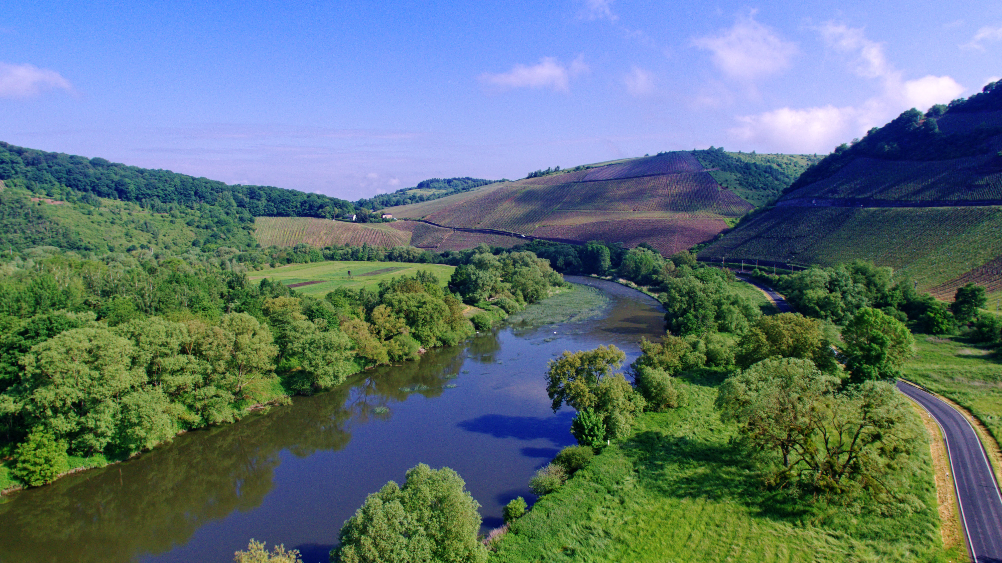
A wide aerial view of the Saar river flowing in a gentle curve through a valley, flanked by lush green trees, fields, and rolling hills.
A view of the Wiltinger Saarbogen nature reserve, showcasing the river loop winding through the surrounding hills and floodplain forests.

Wiltinger Saarbogen history and protected-area timeline

The Wiltinger Saarbogen owes its present-day protected character to a specific episode in the modernisation of the Saar waterway. In the 1980s, large parts of the lower Saar were upgraded for commercial navigation, which usually involved straightening, deepening, or otherwise simplifying the river course. In the Wiltinger Saarbogen area, the approach was different: instead of modifying the existing meandering arc of the river, a new shipping channel, the Saarkanal bei Kanzem, was built along a former river bed to the west. This canal, with its associated weir near Soden and lock near Kanzem, removed the shipping traffic from the natural loop but also left the old river arc largely untouched.

The ecological value of this unintended preservation was formally recognised when the area was designated as the Naturschutzgebiet Wiltinger Saarbogen on 7 August 1997. The establishment of the reserve confirmed the site's status as the last virtually natural stretch of the lower Saar and integrated it into the German system of legally protected nature reserves (Naturschutzgebiete) under Rhineland-Palatinate law. By that time, the canal's design already guaranteed an ecologically adequate discharge through the bypassed loop, ensuring that the river arc retained its hydrological character.

Subsequently, the area was incorporated into the European Union's Natura 2000 network as part of the FFH-Gebiet 6405-303, Serriger Bachtal und Leuk und Saar, reflecting its role as a key component of the broader protected habitat corridor along the lower Saar between the Saarburg region and the river's confluence with the Mosel near Konz.

Wiltinger Saarbogen landscape and geographic character

The landscape of Wiltinger Saarbogen is defined by the curving arc of the lower Saar River as it cuts through the gentle terrain southeast of Konz, on the German side of the border with Luxembourg and just upstream of the Saar's confluence with the Mosel. Rather than a straightened canal-like channel, the river here traces a broad, natural meander, flanked by low terraces and wet floodplain depressions that set the rhythm of the scenery.

A defining feature of the visible landscape is the parallel Saarkanal bei Kanzem to the west, a straight artificial waterway carrying shipping around the natural loop. The juxtaposition between the canal's engineered geometry and the organic curve of the bypassed river arc is one of the area's most recognisable spatial signatures. Heights such as the Rauhof overlook and the Wiltinger Kupp offer elevated viewpoints from which the contrast between natural meander and bypass canal can be appreciated.

Within the river arc itself, the terrain shifts repeatedly between open water, gravel and sand banks, reed-fringed margins, willow thickets, and higher-ground floodplain forest. The relatively low-relief topography of the Saar valley, framed by the vineyards of the Saar and Mosel wine region, gives the reserve a quiet yet visually distinctive character, where water, sediment deposits, and riparian vegetation together produce a soft, layered valley landscape.
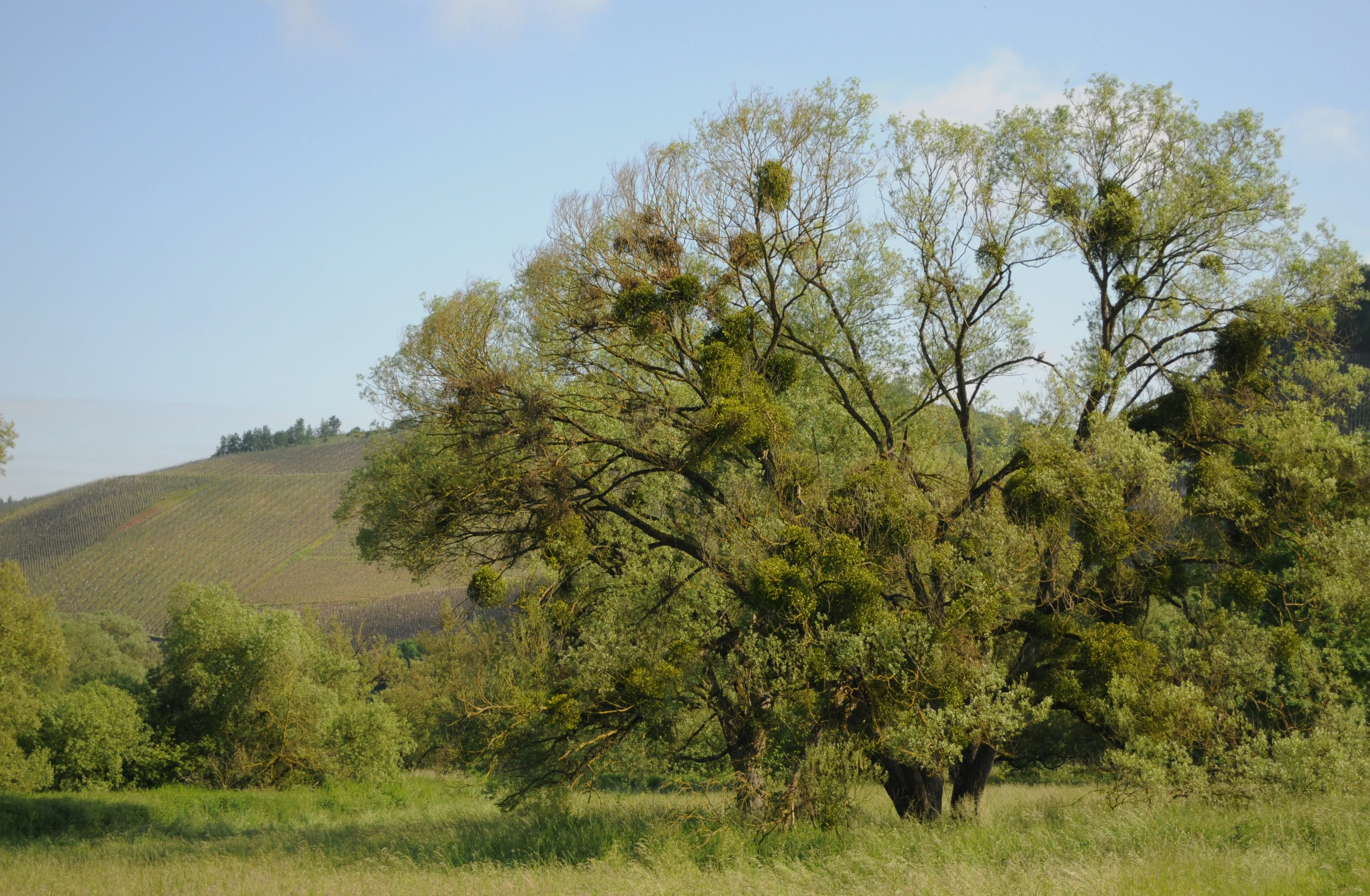
A mature, broad-canopied willow tree covered in numerous green clumps of mistletoe, situated in a grassy river floodplain with a rolling hill in the background.
An old willow tree with mistletoe clusters in the Wiltinger Saarbogen river floodplain.

Wiltinger Saarbogen ecosystems, habitats, and plant life

Ecologically, Wiltinger Saarbogen is a textbook example of a near-natural lowland river ecosystem embedded in an otherwise heavily modified valley. Its nature value stems from the coexistence, on a short stretch, of flowing water and still-water zones, spring-fed seepages, gravel and sand banks, softwood floodplain forest (Auwald), tall-herb and willow scrub communities along the banks, reed beds, large sedge marshes, and moist tall-herb flood meadows.

This combination of structural elements produces a continuous gradient from aquatic to terrestrial habitats along the river arc. Flowing-water and still-water zones with water plant communities dominate the channel and its marginal embayments. Spring emergence points (Quellhorizonte) along the valley flanks add a groundwater-fed component that is unusual in lowland river landscapes. Gravel and sand banks provide dynamic, frequently reworked substrates that support specialised pioneer communities, while reed beds and large sedge marshes stabilise the wet margins and connect the river to its floodplain.

At a slightly higher level in the floodplain succession, the softwood floodplain forest with associated willow scrub forms its own habitat layer, supporting species associated with periodic flooding and natural disturbance regimes. The transition into tall-herb vegetation completes the ecological gradient. Because most comparable stretches of the lower Saar have been altered by earlier river training works, this concentration of intact, mutually reinforcing habitat types along just eight kilometres of river is what gives the reserve its regional nature-conservation importance.

Wiltinger Saarbogen wildlife and species highlights

The wildlife significance of Wiltinger Saarbogen is closely tied to the diversity of riverine and wetland habitats concentrated along the preserved loop of the lower Saar. The mosaic of flowing water, backwaters, gravel banks, softwood floodplain forest, reed beds, and sedge marshes provides breeding, feeding, and sheltering conditions for a wide range of aquatic, semi-aquatic, and riparian species.

The near-natural hydrology, maintained by an ecologically adequate discharge from the bypass canal, supports fish and macroinvertebrate communities typical of unregulated lowland gravel-bed rivers. Slowing margins, backwaters, and spring-fed zones add habitat heterogeneity that benefits less mobile aquatic species and amphibians associated with still or slow-moving water.

At the margins, reed beds and willow scrub offer nesting and cover opportunities for riparian and wetland birds, while the softwood floodplain forest adds vertical structure and seasonal food resources, including fruiting trees and shrubs. Gravel and sand banks in particular are valued as dynamic substrates that support specialised invertebrates and, in undisturbed form, can serve as nesting habitat for ground-nesting bird species. The integration of these elements into a single, contiguous corridor along the Saar is what makes the reserve meaningful for wildlife at a regional scale.

Wiltinger Saarbogen conservation status and protection priorities

The conservation significance of Wiltinger Saarbogen rests on its status as the last largely natural segment of the lower Saar River, an otherwise heavily modified waterway. Protected as a Naturschutzgebiet under Rhineland-Palatinate nature conservation law since 7 August 1997, it enjoys a strong legal protection framework typical of German nature reserves, with restrictions aimed at preserving its ecological character.

The site is embedded in the European Union's Natura 2000 network as part of the FFH-Gebiet 6405-303, Serriger Bachtal und Leuk und Saar. This means that, beyond German national protection, the reserve is recognised at the EU level under the Habitats Directive for its contribution to the conservation of specific habitat types and species listed in the directive. Its integration into a larger Saar valley FFH site links it functionally with protected habitats upstream and reinforces its role as a regional conservation anchor.

A central conservation feature is the continued ecological integrity of the hydrological regime. Because the bypassed river arc receives a legally and technically guaranteed flow, the habitats depending on flooding dynamics, sediment reworking, and water level fluctuation are not simply relict features but remain ecologically active. This combination of legal protection, EU-level recognition, and preserved hydrology is what allows the reserve to function as a long-term refuge of near-natural river ecology in a landscape dominated by viticulture, settlement, and shipping infrastructure.

Top sights and standout views in Wiltinger Saarbogen

Among the reserve's standout qualities are the preservation of a natural river meander in an otherwise heavily engineered valley, the visible contrast between the straight Saarkanal bei Kanzem and the bypassed original loop, and the dense concentration of riverine habitat types within a short eight-kilometre stretch.

Additional highlights include the integration of the site into the EU Natura 2000 network as part of the FFH-Gebiet 6405-303, the legally guaranteed ecological flow through the natural river arc, and the elevated viewpoints such as the Rauhof and the Wiltinger Kupp that allow the landscape to be appreciated in its full valley context.

Best time to visit Wiltinger Saarbogen

Because the Wiltinger Saarbogen is valued primarily for its riverine and wetland character rather than for seasonal phenomena, the most rewarding periods to experience it are spring and early summer, when water levels tend to be more dynamic, riparian vegetation is fully developed, and animal activity along the river margins is at its peak. The reed beds, willow scrub, and floodplain forest are visually most expressive in the warmer months, when the layers of the floodplain are fully leafed out.

Late summer and early autumn can also be attractive, when lower water levels expose more of the characteristic gravel and sand banks and the tall-herb vegetation reaches its full height. In winter, the reserve takes on a quieter, more structural character defined by bare branches, exposed banks, and clearer views across the river arc from nearby heights such as the Rauhof and the Wiltinger Kupp.

Monthly climate preview

Trace long-term representative temperature patterns and monthly precipitation averages

Wiltinger Saarbogen Climate Normals, Annual Temperature and Precipitation Rhythm

Historical data recorded between 1991 and 2000 at a representative coordinate highlights measured shifts in monthly temperature extremes and precipitation totals across Wiltinger Saarbogen. Examining the complete twelve-month record clarifies continuous annual climate trends without relying on short-term weather forecasts.
Annual mean9 °C
0 °C19 °C
Jan
Feb
Mar
Apr
May12°
Jun16°
Jul19°
Aug18°
Sep14°
Oct
Nov
Dec
Warmest month
July

18.6 °C

Coolest month
January

-0.2 °C

Wettest month
December

2.9 mm/day

Driest month
April

1.7 mm/day

Park location guide

Geography guide, regional context, and park location map for Wiltinger Saarbogen

Wiltinger Saarbogen park geography, regions, and map view in Germany

Understand where Wiltinger Saarbogen sits in Germany through a broader geographic reading of the surrounding landscape, nearby location context, and its mapped position within the national park landscape.

How Wiltinger Saarbogen fits into Germany

Germany is a federal republic in Western and Central Europe with a population of over 83 million across sixteen constituent states. It is Europe's largest economy by nominal GDP and a major global exporter and importer. The capital is Berlin, and the country borders Denmark, Poland, Czech Republic, Austria, Switzerland, France, Luxembourg, Belgium, and the Netherlands.

Wider geography shaping Wiltinger Saarbogen in Germany

Germany is located in Western and Central Europe, spanning 357,022 km². It borders Denmark to the north, Poland and the Czech Republic to the east, Austria and Switzerland to the south, and France, Luxembourg, Belgium, and the Netherlands to the west. The country has coastlines on the Baltic Sea and North Sea to the north, with the Alps located in the southern region.

Map view of Wiltinger Saarbogen

Use this park location map to pinpoint Wiltinger Saarbogen in Germany, understand its exact geographic position, and read its mapped placement within the surrounding landscape more clearly.

Pigeon | © OpenStreetMap contributors

Location context for Wiltinger Saarbogen

Rhineland-Palatinate

Explore natural river scenery, wetland habitats, and riparian terrain across the reserve.

Wiltinger Saarbogen Photos and Landscapes: Visualizing the Protected River Meander

Examine detailed photographs showcasing the natural river meander, gravel banks, and floodplain forests of Wiltinger Saarbogen. Visual records clarify the complex terrain and protected habitat mosaic along the lower Saar valley.

A wide aerial view of the Saar river flowing in a gentle curve through a valley, flanked by lush green trees, fields, and rolling hills.

A wide angle view of the Saar river flowing through a forested valley with a railway track visible on the right foreground.

A mature, broad-canopied willow tree covered in numerous green clumps of mistletoe, situated in a grassy river floodplain with a rolling hill in the background.

Park atlas

Compare nearby river valley reserves and connected regional protected areas

Other Parks Near Wiltinger Saarbogen and Surrounding Protected Landscapes

Exploration of protected areas near Wiltinger Saarbogen reveals broader regional river valleys and interconnected wetland habitats. Comparing adjacent reserves expands geographical context across the surrounding lowland terrain and river ecosystems.
Watercolor painting of a rolling green forest landscape with a winding path and soft, abstract hills in the background.
Nature reserveRhineland-Palatinate
About 4.9 km away#1 closest

Northeast

Mattheiser Wald Nature Reserve: A Protected Forest Landscape in Rhineland-Palatinate

Ecological mapping of urban forest and valley terrain

Mattheiser Wald represents a vital nature reserve and Natura 2000 site in the Trier region. The area is characterized by high-value oak and hornbeam woodland, abandoned military disturbance zones that host rare wildlife, and an intricate stream valley system. This atlas entry provides a detailed look at the reserve's topography and its status as a critical conservation landscape within an urban environment.

Area
4.47 km²
Established
2003
Relief
Upland
Climate
Temperate
Watercolor painting of a green, rolling hillside landscape with faint pink floral details in the foreground.
Nature reserveRheinland-Pfalz
About 5.3 km away#2 closest

Northwest

Perfeist bei Wasserliesch: Protected Grassland and Botanical Mapping in Rheinland-Pfalz

A regional sanctuary for rare orchids and calcareous meadow flora.

Perfeist bei Wasserliesch represents a significant protected area within the German Moselle landscape. Spanning 22 hectares of dry, sun-exposed calcareous soil on the Liescher Berg, the reserve offers a focused look at open grassland ecology. Its unique status as a botanical reference point highlights how small-scale protected land maintains rare plant species and fragile meadow habitats against the backdrop of the surrounding Moselle valley hill country.

Area
0.22 km²
Established
1986
Nature reserveRheinland-Pfalz
About 9.7 km away#3 closest

West

Langheck bei Nittel Nature Reserve: A Detailed Atlas of Protected Moselle Landscapes

Ecological geography and calcareous grassland habitat in Rheinland-Pfalz

Langheck bei Nittel is a significant nature reserve located in the Upper Moselle valley of Germany. The site protects a rare mosaic of calcareous dry grasslands, shrubbery, and forest edges that host a high concentration of orchid species. As a critical component of the regional biotope network, it offers insight into the conservation of warm-loving flora and the management of stony, nutrient-poor landscapes.

Area
0.42 km²
Established
1998
A minimalist watercolor painting featuring soft, abstract layers of green hills, purple distant ridges, and a pale yellow sky against a white background.
Nature reserveRheinland-Pfalz
About 11 km away#4 closest

North

Gillenbachtal Nature Reserve: Geography and Protected Woodland Boundaries in Rheinland-Pfalz

A rare forest gorge and orchid habitat near the city of Trier.

Trace the boundaries and ecological features of Gillenbachtal, a designated nature reserve characterized by its steep-sided forest gorge and varied microclimates. This area serves as a critical protected enclave featuring deadwood habitats, limestone outcrops, and traditional orchard meadows that contrast with the urban development of nearby Trier.

Area
38.49 km²
Established
1995
A soft watercolor painting of a landscape featuring a small river or pond in the center, flanked by green trees on the left and pink-flowered trees on the right, with low hills in the distance.
Nature reserveLuxembourg
About 12 km away#5 closest

West

Naturschutzgebitt Kelsbaach Nature Reserve: A Geographical Overview of Luxembourg Landscapes

Dolomite rock formations and protected dry grassland ecosystems

Naturschutzgebitt Kelsbaach preserves a distinctive environmental gradient across the Moselle valley hillsides in Luxembourg. From exposed dolomite cliffs and arid plateau grasslands to the shaded Kelsbaach stream gorge, the reserve illustrates the complex interplay of regional geology and microclimate. This protected area offers a precise look at local biodiversity habitats and the lasting impact of historical land use on the natural terrain.

Area
0.755 km²
Established
1998
Relief
Upland
Climate
Temperate
Nature reserveSaarland
About 15 km away#6 closest

South

Steilhänge der Saar Nature Reserve: Mapped Protected Landscapes and River Valley Geography

Protected river slopes and forested terrain in Saarland

The Steilhänge der Saar nature reserve encompasses steep, wooded hillsides rising above the Saar river valley. This consolidated protected area features complex ecological gradients between rocky, sun-exposed upper slopes and shadowed tributary streams, serving as a critical habitat zone and a defining feature of the regional Saarland landscape.

Area
10.86 km²
Established
2017
IUCN
IV
Nature reserveSaarland
About 22 km away#7 closest

Southeast

Wadrilltal Nature Reserve: Geographic Context and Mapped Protected Landscapes in Saarland

A protected stream valley habitat in the Hochwald region of Germany.

Wadrilltal represents a crucial nature reserve that shelters a near-natural stream valley system within the Saarland municipality of Wadern. The area preserves a structural diversity of wet meadows, montane mat-grass swards, and floodplain forests that form part of the Natura 2000 network. Gain geographic insight into the valley's slopes and river corridor, which extend across state boundaries to maintain significant regional biodiversity.

Area
1.67 km²
Established
2016
Scope
Terrestrial
Water
Major water bodies
A horizontal watercolor painting of a wetland scene with still water, grassy banks, small islands, and rolling hills in the background.
Nature reserveSchengen
About 23 km away#8 closest

Southwest

Haff Réimech Nature Reserve: Wetland Geography and Protected Landscape in Schengen

Reclaimed industrial wetlands in the Moselle river valley

Haff Réimech is a protected wetland sanctuary located in the Moselle valley near Schengen. The reserve features approximately forty shallow lakes created from former sand and gravel pits, now surrounded by reedbeds and riparian woodland. This mosaic landscape serves as a key site for migratory bird species, demonstrating a unique transition from industrial extraction to a managed, ecologically rich floodplain environment.

Area
1.008 km²
Established
1998
Relief
Lowland
Climate
Temperate

Common questions about visiting, size, designation, and location context for Wiltinger Saarbogen

Wiltinger Saarbogen FAQs for park facts, access, geography, and protected area context

Find quick answers about Wiltinger Saarbogen, including protected-area facts, park geography, trail and visitor context, and how the park fits into its surrounding country and regional landscape.
MoriAtlas Explorer

Continue Your Protected Areas Search Across the Global Atlas

Deepen your exploration by continuing the structured search for national parks and protected areas worldwide. Utilize the comprehensive filtering capabilities to compare different conservation landscapes and refine your understanding of global park geography. Discover more about the distribution and characteristics of protected natural areas.

Global natural geography