
Mori Atlas logo
Nature reserveWindberg

A historic forested ridge overlooking the Weißeritz valley within the eastern Ore Mountains

Windberg Nature Reserve: Exploring the Geography and Protected Forest Landscapes of Saxony

Windberg rises above the city of Freital as a distinct forested ridge, serving as a vital nature protection area in the Free State of Saxony. This protected landscape is defined by its deep oak-beech forests, significant tectonic fissure caves, and a rich history shaped by early coal mining and mountain railway engineering. The ridge provides a unique vantage point across the Osterzgebirge foothills and the broader Dresden Elbe valley, offering deep insights into the region's geological and ecological character.

forested ridgeHausbergnature protection areaoak-beech forestbat habitatstag beetle habitat
A flat-style vector illustration of a green, forested hill with a radio tower at the peak, overlooking a waterfall and winding river in a canyon, under a soft pastel sky.

Windberg

Nature reserve

Park overview

Structured park overview, official facts, and landscape profile for Windberg

Windberg park facts, protected area profile, and essential visitor context

Review the core facts for Windberg, including designation, size, terrain, visitor scale, habitats, and operating context in one park-focused overview.

About Windberg

The Windberg is a prominent, broadly forested ridge lying within the urban area of Freital, directly southwest of Dresden in the Free State of Saxony. Reaching an elevation of 353 meters, it forms the northwestern edge of the Döhlener Becken, the landscape basin between Dresden and the eastern slopes of the Ore Mountains, and acts as a visual anchor for the city of Freital. From a distance, the Windberg's elongated, plateau-like silhouette is one of the most recognizable landforms on the northwestern skyline of the Dresden region.

Nature conservation is central to the mountain's modern identity. Since 1967, the Windberg has been protected as a Natur- und Landschaftsschutzgebiet, a combined nature and landscape protection area. The designation reflects the exceptional ecological quality of its forests, which include extensive stands of sessile oak and beech woodland of regional importance. The combined forests, rocky and stony slopes, and warm microclimate on the upper slopes create habitat for a wide range of protected species, several of which are listed under the European Habitats Directive.

Beyond its ecological value, the Windberg has a layered human history. Its geology, conglomerate of the Rotliegend period with embedded coal seams, drove intensive hard-coal extraction in the nineteenth century. Shafts like the Windbergschacht, Segen-Gottes-Schacht, Neuhoffnungsschacht, Glückauf-Schacht, Marienschacht, and Augustusschacht ringed the mountain, and their surviving spoil heaps, surface collapses, and the preserved Huthaus shape today's cultural landscape. The Windbergschacht itself, sunk to a depth of 412 meters and operated from 1845 until 1881, was connected to the Windbergbahn in 1857, the pioneering mountain railway that carried coal from these slopes.

Today the Windberg combines three overlapping identities: a protected natural area with rich forest biodiversity, a regionally significant historical mining landscape, and a popular local recreation and lookout point above the Weißeritz valley. Its panoramic views toward the Tharandter Wald, the Osterzgebirge, and the Dresden Elbe valley reinforce its role as a defining landmark for the communities around it.

Quick facts and research context for Windberg

The Windberg reaches 353 meters above sea level and rises within the city limits of Freital, just southwest of Dresden in Saxony. Geologically it consists of Rotliegend conglomerate with embedded hard-coal seams, the same geology that supported nineteenth-century coal mining in the Döhlener Becken.

The mountain has been designated a nature and landscape protection area (Naturschutzgebiet) since 1967, primarily for its near-natural sessile oak and beech forests, its populations of rare bats, beetles, and moths, and its value for forest birds. The Windbergspalte, a tectonic fissure cave on the north flank, is 44 meters deep and counts as the deepest cave in Saxony. Since 1950 the Windberg has also hosted the traditional cross-country race "Rund um den Windberg."

Protection and recognition

Documented terrestrial protection scope and 1967 designation timeline

Windberg Protection Status and Designated Area Recognition History

Windberg holds a documented terrestrial protection status established in 1967 across its designated landscape. Official conservation records outline the governing protection scope and historical designation metrics for structural analysis.

Protection details

Protection scope
Terrestrial
Designated year
1967
Transboundary protection
No
Park context

Deeper park guide and search-rich context for Windberg

Windberg history, landscape, wildlife, and travel context

Explore Windberg through its history, landscape character, ecosystems, wildlife, conservation priorities, cultural context, and seasonal travel timing in a structured park guide built for atlas discovery and search intent.

Why Windberg stands out

The Windberg is best known as the Hausberg of Freital and as the namesake of the Windbergbahn, Germany's first mountain railway. It is also recognized for its ecologically valuable oak-beech forests, which harbor protected species such as the greater mouse-eared bat, the stag beetle, and the Jersey tiger moth, and for the Windbergspalte, Saxony's deepest cave.
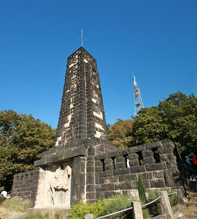
A stone obelisk monument dedicated to King Albert featuring a carved relief panel, set against a bright blue sky and surrounded by dense trees.
The King Albert Monument standing on Windberg in Freital, Germany.

Windberg history and protected-area timeline

The modern history of the Windberg is inseparably tied to coal mining. The Rotliegend conglomerate of the mountain contains hard-coal seams that were exploited intensively during the nineteenth century. Numerous shafts were sunk around the Windberg, including the Segen-Gottes-Schacht, Neuhoffnungsschacht, Glückauf-Schacht, Marienschacht, and Augustusschacht, whose spoil heaps and surface deformations still mark the flanks of the ridge.

On the summit plateau itself stood the Windbergschacht, operated by the Potschappler Aktienverein from 1845 and sunk to a depth of 412 meters. In 1857 the shaft was connected to the newly opened Windbergbahn, Germany's first mountain railway, which carried coal down the steep slopes. The shaft ceased operation in 1881, but its surviving Huthaus, a traditional mining office building, remains a visible reminder of the mining era and now serves as an animal shelter. On the eastern plateau, formerly also called Kieferberg, a memorial commemorates the victims of the 1869 firedamp explosion in the Segen-Gottes and Neuhoffnungsschacht shafts.

In recognition of its ecological value, the Windberg has been formally protected as a nature and landscape conservation area since 1967. Since 1950, the mountain has also been the site of the traditional cross-country race "Rund um den Windberg," anchoring it as a long-standing recreational landmark in the life of Freital.

Windberg landscape and geographic character

The Windberg presents a striking, elongated silhouette. A narrow northwestern ascent opens onto a long, broad, densely wooded plateau that characterizes the mountain's profile from the city below. The ridge forms part of the northwestern fringe of the Osterzgebirgsflanke, the eastern slopes of the Ore Mountains, where it meets the lower Döhlener Becken.

The southern, western, and northern views from the summit extend across the Weißeritz valley below, framed by the industrial and residential fabric of Freital, with the Tharandter Wald to the southwest, the higher ridges of the Osterzgebirge in the distance, and the Dresden Elbe valley opening out to the north. On the northern flank lies the Windbergspalte, a tectonic fissure cave 44 meters deep, the deepest cave in Saxony, with a parallel, impassable fissure zone on the southern flank. Mining-era spoil heaps, natural subsidence hollows, and surface breaks along the flanks are reminders that the mountain's present-day surface is partly the product of underground extraction.
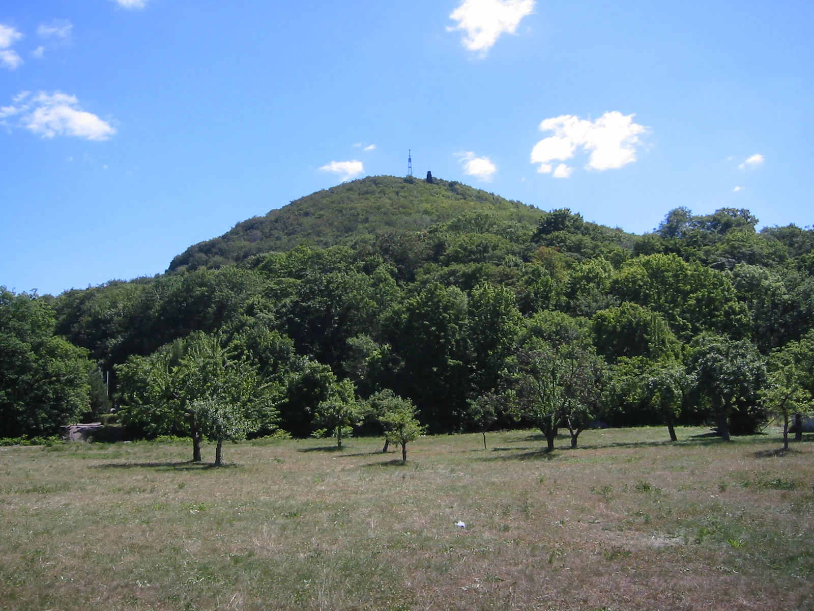
A gentle, tree-covered hill rises above a grassy field under a bright blue sky with scattered clouds.
Side view of the Windberg hill near Freital, Germany.

Windberg ecosystems, habitats, and plant life

Ecologically, the Windberg is dominated by near-natural broadleaf forest, with major stands of sessile oak and beech woodland of regional conservation importance along the northwestern slopes. The dry, warm upper slopes support a lighter variant of the Hainsimsen-Traubeneichenwald, a sessile oak forest community, while the broader forest mosaic provides continuous habitat across the entire plateau.

This combination of closed canopy forest, varied microclimate, and rocky exposures creates the conditions for a rich community of rare and protected invertebrates, bats, and reptiles, complemented by an unusually intact community of forest-breeding birds. The protected-area status of the Windberg, in force since 1967, reflects the high ecological coherence and naturalness of these forest habitats within an otherwise heavily settled landscape.
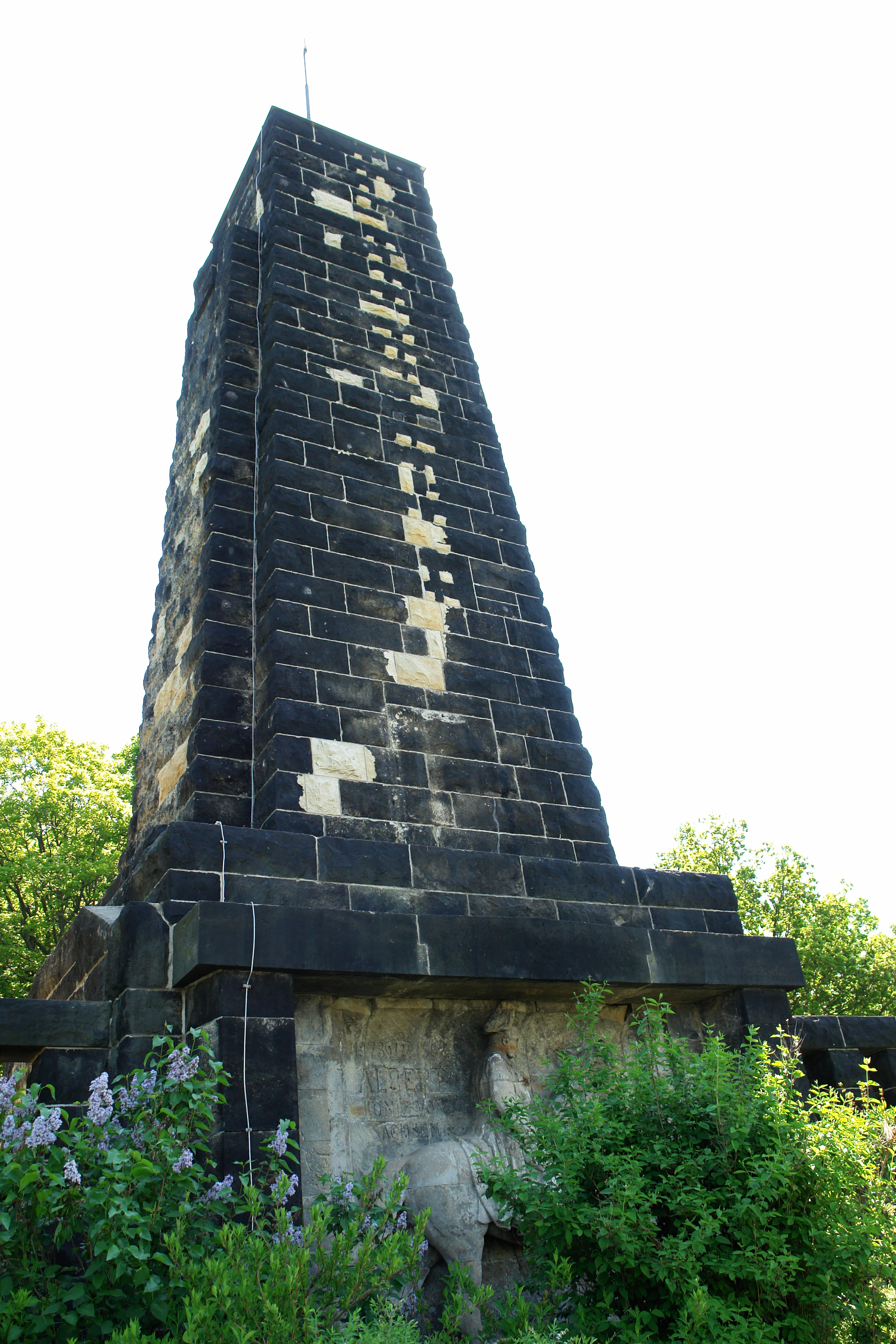
A tall, dark stone monument with a tapered, rectangular pillar shape is partially surrounded by green bushes and trees against a bright, overexposed sky.
The King Albert Monument standing amidst greenery on the Windberg.

Windberg wildlife and species highlights

The Windberg's woodlands host a notable range of protected fauna. Bats are a particular focus of conservation interest, with the strictly protected greater mouse-eared bat (Myotis myotis) recorded in its habitats. Insects of conservation concern include the stag beetle (Lucanus cervus), classified as strongly endangered, and the Jersey tiger moth (Euplagia quadripunctaria), a priority species under the European Habitats Directive.

The mountain is also of significant ornithological value. Its forest stands provide breeding habitat for black woodpecker (Dryocopus martius), grey-headed woodpecker (Picus canus), red-breasted flycatcher (Ficedula parva), European honey buzzard (Pernis apivorus), and stock dove (Columba oenas). On the dry, warm upper slopes, the smooth snake (Coronella austriaca) and the more widespread sand lizard (Lacerta agilis) find suitable conditions within the open oak woodland.
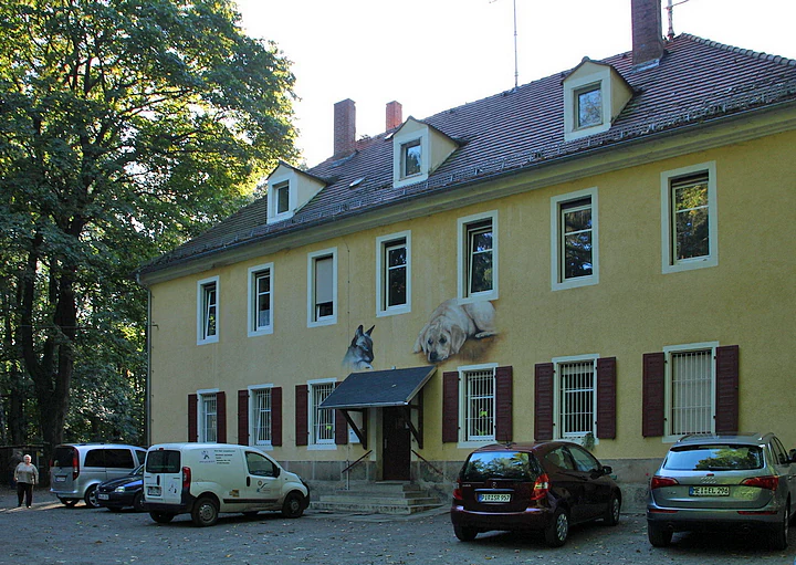
A two story, light yellow building with a gabled roof and brown shutters. It has a small entrance porch and several windows. Several cars are parked in front of the building. Large green trees are visible to the left.
The historical Huthaus of the Windbergschacht, a former coal mining structure now serving as an animal shelter in the Windberg area.

Windberg conservation status and protection priorities

The Windberg's protected status, in place since 1967, recognizes both its natural value and its importance within the regional ecological network of the Landkreis Sächsische Schweiz-Osterzgebirge. The designation covers the near-natural oak and beech forest stands and the broader complex of forest, rock, and slope habitats that together support rare species such as the greater mouse-eared bat, stag beetle, and Jersey tiger moth, as well as priority bird species of conservation concern.

The mountain's protected-area role is also shaped by its location at the interface between the densely populated Dresden-Freital corridor and the forested slopes of the Ore Mountains. In this context, the Windberg functions as a reservoir of forest biodiversity, a stepping-stone within the wider Saxon protected-area network, and an example of how historical mining pressure can be reconciled with long-term nature protection.

Windberg cultural meaning and human context

The Windberg has shaped local identity since well before modern conservation. Several hypotheses connect its name to the Sorbian settlers historically present in the region, whether through a derivation from "Wendenberg" or through earlier names linked to vineyard or pasture use, reflecting the layered cultural history of the eastern Ore Mountains foothills.

In the nineteenth and twentieth centuries, the mountain acquired a strong industrial and transportational identity through coal mining and through its role as the namesake of the Windbergbahn, Germany's first mountain railway. The König-Albert-Denkmal on the eastern slopes and the 1869 miners' memorial on the eastern plateau commemorate these intertwined histories of industry, technology, and human loss. The long-running "Rund um den Windberg" cross-country race, held annually since 1950, anchors the mountain as a continuing focal point of community life in Freital.

Top sights and standout views in Windberg

The Windberg is unique within the Saxon landscape for combining a deeply forested, legally protected hillside ecosystem with the visible footprint of nineteenth-century coal mining and the pioneering history of the Windbergbahn, Germany's first mountain railway. From its plateau, panoramic views reach across the Weißeritz valley, the Tharandter Wald, and the Osterzgebirge toward the Dresden Elbe valley.

Equally notable is the Windbergspalte, Saxony's deepest cave at 44 meters, a tectonic fissure on the mountain's northern flank. Together with its protected oak-beech forests, rare bat populations, stag beetles, and a strong community of forest-breeding birds, the mountain forms one of the most ecologically and culturally layered hills in the immediate Dresden region.

Best time to visit Windberg

As a forested ridge protected as a nature and landscape conservation area, the Windberg is accessible year-round, but the experience of its woodland and viewpoints changes with the seasons. Spring brings fresh foliage and active bird song across the oak and beech stands, including breeding species such as the honey buzzard and red-breasted flycatcher. Summer offers the densest forest cover and full panoramic views from the summit plateau over the Weißeritz valley and the surrounding hills.

Autumn reveals broadleaved-color change across the forest canopy, while the open views remain clear toward the Osterzgebirge and the Tharandter Wald. Winter brings the traditional "Rund um den Windberg" cross-country race season, with quieter conditions on the wooded slopes and unobstructed vistas from the summit in clear weather.

Monthly climate preview

Long term representative point averages for monthly weather variations

Windberg Climate Normals, Annual Temperature and Precipitation Patterns

Historical data records measured monthly temperature and precipitation ranges across the Windberg protected coordinate from 1991 to 2020. Examining the complete twelve month profile provides deeper insight into long term climate rhythms and seasonal averages.
Annual mean8 °C
-2 °C19 °C
Jan-2°
Feb-1°
Mar
Apr
May13°
Jun17°
Jul19°
Aug19°
Sep14°
Oct
Nov
Dec-1°
Warmest month
July

19.1 °C

Coolest month
January

-1.8 °C

Wettest month
July

2.8 mm/day

Driest month
April

1.3 mm/day

Park location guide

Geography guide, regional context, and park location map for Windberg

Windberg park geography, regions, and map view in Germany

Understand where Windberg sits in Germany through a broader geographic reading of the surrounding landscape, nearby location context, and its mapped position within the national park landscape.

How Windberg fits into Germany

Germany is a federal republic in Western and Central Europe with a population of over 83 million across sixteen constituent states. It is Europe's largest economy by nominal GDP and a major global exporter and importer. The capital is Berlin, and the country borders Denmark, Poland, Czech Republic, Austria, Switzerland, France, Luxembourg, Belgium, and the Netherlands.

Wider geography shaping Windberg in Germany

Germany is located in Western and Central Europe, spanning 357,022 km². It borders Denmark to the north, Poland and the Czech Republic to the east, Austria and Switzerland to the south, and France, Luxembourg, Belgium, and the Netherlands to the west. The country has coastlines on the Baltic Sea and North Sea to the north, with the Alps located in the southern region.

Map view of Windberg

Use this park location map to pinpoint Windberg in Germany, understand its exact geographic position, and read its mapped placement within the surrounding landscape more clearly.

Pigeon | © OpenStreetMap contributors

Location context for Windberg

Freistaat Sachsen

Explore detailed imagery of the terrain, oak beech forests, and regional overlooks of Saxony.

Windberg Photos and Landscape Scenery: Visualizing the Forested Ridge and Protected Habitats

Examine comprehensive visual documentation showcasing the forested slopes, deep tectonic fissures, and distinct topography defining the protected landscape. Visual research clarifies the complex terrain and native habitats characterizing the historic mountain environment.

A stone obelisk monument dedicated to King Albert featuring a carved relief panel, set against a bright blue sky and surrounded by dense trees.

A wide landscape view of a yellow two story manor building with a red tile roof and a central tower, set against a green meadow and a forested hill in the background under a blue sky.

A gentle, tree-covered hill rises above a grassy field under a bright blue sky with scattered clouds.

A tall, dark stone monument with a tapered, rectangular pillar shape is partially surrounded by green bushes and trees against a bright, overexposed sky.

A two story, light yellow building with a gabled roof and brown shutters. It has a small entrance porch and several windows. Several cars are parked in front of the building. Large green trees are visible to the left.

Park atlas

Compare regional protected areas and connected terrain across eastern Saxony

Explore Other Parks Near Windberg and Surrounding Protected Landscapes

Continue exploring other protected areas near Windberg by comparing adjacent forested ridges and regional nature reserves. Examining surrounding landscapes helps place local Saxon terrain within a broader geographical context.
Nature reserveSaxony
About 8.9 km away#1 closest

Southwest

Weißeritztalhänge Nature Reserve: Protected Slope Forests and River Valley Geography

Regional landscape profile in Saxony, Germany

Weißeritztalhänge represents a significant nature reserve situated along the Wilde Weißeritz in Saxony. The protected area features expansive slope forests that transition from the Saxon lowlands into the Erzgebirge, providing a critical refuge for diverse woodland and river-dwelling species.

Area
4.486 km²
Established
1961
IUCN
IV
Relief
Upland
Watercolor painting of a soft landscape featuring distant hills and foreground vegetation in shades of green, yellow, and soft red.
Nature reserveSachsen
About 14 km away#2 closest

East

Dresdner Elbtalhänge Nature Reserve: Geography, Mapped Boundaries, and Landscape Context

An essential nature reserve along the Elbe valley in Sachsen

Dresdner Elbtalhänge captures the striking transition between the flat Elbe floodplain and the Westlausitz hill region. This detailed atlas entry covers the reserve's unique geomorphology, including its incised ravine systems, south-facing oak forests, and exposed rock formations that define its protected character within Sachsen.

Area
203.6 km²
Established
2007
IUCN
IV
A watercolor illustration depicting rolling, soft hills and green vegetation with distant, faded mountains in the background, set against a plain white background.
Nature reserveGermany
About 14 km away#3 closest

East

Spargründe bei Dohna: Nature Reserve and Protected Valley Landscapes in Germany

Examining the crystalline ravines and forest ecosystems of the Saxon landscape

Spargründe bei Dohna stands as a distinct nature reserve at the northern margin of the Elbtalschiefergebirge. The site encompasses narrow, steeply-sided valleys carved into Dohna Granodiorite, creating a rugged terrain of rocky ridges and shaded deciduous woodland. This geographic overview examines the boundaries and natural features of the reserve, highlighting its role within the wider Müglitztal protected area network.

Area
0.373 km²
Relief
Upland
Climate
Temperate
Access
Easy access
A pale, soft watercolor illustration showing a horizontal landscape of light green trees, shrubs, and rolling grassy plains on a white background.
Nature reserveGermany
About 15 km away#4 closest

East

Elbinseln Pillnitz und Gauernitz: A Study in Protected Saxon River Landscapes

Examining floodplain geography and rare river island ecosystems

Located in the Elbe valley between Dresden and Meissen, Elbinseln Pillnitz und Gauernitz preserves the final natural river islands within the state of Saxony. This protected nature reserve anchors a vital network of alluvial soils, riparian woodlands, and unarmored riverbanks, offering a unique perspective on the dynamic floodplain geography of Germany's major river corridors.

Area
0.235 km²
Established
2006
IUCN
IV
Relief
Lowland
A horizontal watercolor illustration showing a calm pond in the foreground, with lush green vegetation on the banks and rolling hills in the background under a soft sky.
Nature reserveMeißen
About 16 km away#5 closest

North

Dippelsdorfer Teich Nature Reserve: Geographic Insights and Landscape Context

Historic Saxon pond management and regional protected landscape.

The Dippelsdorfer Teich serves as a primary example of historical pond construction and nature protection in the northern Dresden countryside. This 69 hectare reservoir captures a blend of ecological, cultural, and recreational values within the Meißen region. Users can examine its physical layout, the dam structure, and the integration of heritage transport within this managed lowland environment.

Area
0.69 km²
Established
1528
Relief
Lowland
Scope
Terrestrial
A watercolor painting showing a calm pond with a small island of green trees and distant rolling hills under a soft pink and yellow sky.
Nature reserveMeißen District
About 21 km away#6 closest

North

Frauenteich Moritzburg: Mapping the Protected Wetland Landscapes of Meißen District

Glacial pond basins and diverse forest habitats in Saxony.

Frauenteich Moritzburg serves as a core component of Saxony's pond landscape, protecting a rich sequence of shoreline vegetation and open water. Its geography reflects the results of ancient glacial activity, creating a unique environment where sandy ridges and wet meadows coexist. This nature reserve provides essential refuge for bird populations, making it a focal point for understanding the natural, protected terrain within the broader Meißen District environment.

Area
2.02 km²
Established
1954
IUCN
IV
Relief
Lowland
Nature reserveSächsische Schweiz-Osterzgebirge
About 22 km away#7 closest

South

Weicholdswald Nature Reserve: Mapped Protected Landscapes of the Eastern Ore Mountains

A preserved beech forest enclave within the Sächsische Schweiz-Osterzgebirge

Weicholdswald stands as a primary nature reserve in the Sächsische Schweiz-Osterzgebirge district, known for its 160-year-old beech trees and extensive deadwood habitats. This protected area provides a rare look at near-natural forest ecosystems that have remained free from historic clear-cutting or coniferous monocultures, maintaining rich biodiversity across its streams and granitic slopes.

Area
1.037 km²
Established
1961
IUCN
IV
A pale, soft watercolor painting depicting a small arched bridge crossing a gentle stream within a rolling green valley.
Protected landscapeSaxony
About 23 km away#8 closest

Northeast

Seifersdorfer Tal Protected Landscape and Cultural Heritage in Saxony

A historic garden monument and river valley ecosystem

The Seifersdorfer Tal is a protected landscape defining the Große Röder valley. Beyond its cultural status as one of Germany's earliest English-style landscape gardens, the area serves as a vital riverine corridor and nature reserve. The terrain offers a unique blend of rocky outcrops, wooded slopes, and meadows linked by historic footpaths and 18th-century allegorical monuments.

Area
2.88 km²
Established
1960
Relief
Upland
Climate
Temperate

Common questions about visiting, size, designation, and location context for Windberg

Windberg FAQs for park facts, access, geography, and protected area context

Find quick answers about Windberg, including protected-area facts, park geography, trail and visitor context, and how the park fits into its surrounding country and regional landscape.
MoriAtlas Explorer

Continue Your Protected Areas Search Across the Global Atlas

Deepen your exploration by continuing the structured search for national parks and protected areas worldwide. Utilize the comprehensive filtering capabilities to compare different conservation landscapes and refine your understanding of global park geography. Discover more about the distribution and characteristics of protected natural areas.

Global natural geography