Mori Atlas logo
Nature reserveWindbrackenholz

Understanding the ecological role and landscape context of this northwestern German forest fragment.

Windbrackenholz Nature Reserve: Mapped Geographic Boundaries and Protected Woodland Identity

(Naturschutzgebiet Windbrackenholz)

Windbrackenholz serves as a vital oak-beech mixed forest reserve within the Cuxhaven district of Lower Saxony. This protected area represents the classic Geest lowland woodland mosaic, preserving mature deciduous stands amidst surrounding coniferous plantations and agricultural grasslands. By mapping the boundaries of this 34-hectare reserve, the broader regional forest structure and the conservation history of the northwestern German landscape come into focus.

nature reserveNaturschutzgebietoak-beech forestmixed broadleaf foreststate forestLower Saxony

Windbrackenholz

Nature reserve

Park overview

Structured park overview, official facts, and landscape profile for Windbrackenholz

Windbrackenholz park facts, protected area profile, and essential visitor context

Review the core facts for Windbrackenholz, including designation, size, terrain, visitor scale, habitats, and operating context in one park-focused overview.

About Windbrackenholz

Windbrackenholz is a small but ecologically meaningful nature reserve in the northern part of the Landkreis Cuxhaven, in the Geestland area of Lower Saxony. It sits within the wider Windbrackenholz state forest, a tract of public woodland that gives the protected area its name. The reserve itself is a clearly defined subset of that forest, established to safeguard a representative example of mixed deciduous woodland in a region where such habitats have long been shaped by forestry, grazing, and land conversion.

The geographical setting is typical of the northwestern German Geest, with gentle, low-lying terrain barely above nine meters. The protected area stands at the interface between natural broadleaf forest, planted conifer stands, and agricultural grassland, giving it a transitional character that is often valued in regional conservation planning. The reserve was formally designated on 2 August 1985 under the designation NSG LÜ 121, which links it to the broader network of protected sites in the Cuxhaven district managed through both local and state-level authority.

Although Windbrackenholz is no large wilderness, it represents a piece of the older forest landscape of the region, where beech and oak once dominated and where fragments have been preserved and managed as refuges for native woodland species. Its role is more about continuity and habitat integrity than spectacle: it contributes to a mosaic of small woodland reserves that together maintain forest-associated biodiversity in an otherwise heavily used cultural landscape.

Quick facts and research context for Windbrackenholz

Windbrackenholz is a nature reserve designated under the code NSG LÜ 121, covering about 34 hectares of mixed deciduous forest in the northwestern part of the larger Staatsforst Windbrackenholz. It lies near Köhlen, in the town of Geestland within the Landkreis Cuxhaven of Lower Saxony, at elevations of roughly 9 to 16 meters above sea level. The site has been protected since 2 August 1985 and is classified as an IUCN Category IV habitat and species management area, with the Landkreis Cuxhaven acting as the responsible lower nature protection authority and the NLWKN providing state-level oversight.

Protection and recognition

Documented conservation status, official designation history, and administrative records

Windbrackenholz Protection Status and International Recognition Data

Windbrackenholz protection status data brings together documented conservation records, management scope details, and official designation metrics for structured analysis. Protected area designation parameters and international recognition sources provide an authoritative baseline for regional environmental research.

Protection details

WDPA ID
166323
Park context

Deeper park guide and search-rich context for Windbrackenholz

Windbrackenholz history, landscape, wildlife, and travel context

Explore Windbrackenholz through its history, landscape character, ecosystems, wildlife, conservation priorities, cultural context, and seasonal travel timing in a structured park guide built for atlas discovery and search intent.

Why Windbrackenholz stands out

Windbrackenholz is best known as a compact example of an oak-beech mixed forest reserve in the northwestern German lowlands. Its defining feature is the mature oak-beech woodland with scattered spruce stands, embedded within a larger state forest and bordered by conifer plantations and grazed grassland, reflecting the classic forest mosaic of the Geest landscape near Bad Bederkesa.
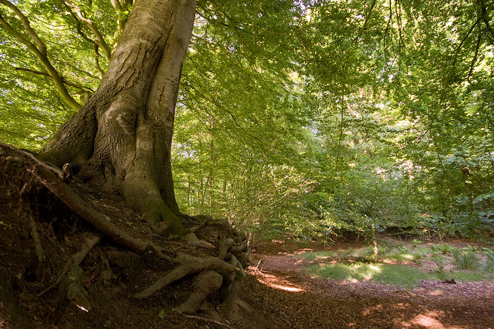
A close-up view of a large beech tree with exposed gnarled roots at the base, leading into a dense green forest interior.
A view of the forest interior at Windbrackenholz, highlighting the prominent roots of a mature beech tree.

Windbrackenholz history and protected-area timeline

The protected status of Windbrackenholz dates to 2 August 1985, when the area was formally designated as a nature reserve under the German Naturschutzgesetz framework. The designation was recorded under the identifier NSG LÜ 121, a reference familiar within Lower Saxony's catalog of Landesnaturschutzgebiete. The reserve covers about 34 hectares of the larger Windbrackenholz state forest, with continuous management responsibility held by the Landkreis Cuxhaven as the lower nature protection authority and by the NLWKN for state-level oversight. Specific details about earlier forest history, ownership changes, or pre-1985 land use are not documented in the available source material.

Windbrackenholz landscape and geographic character

The landscape of Windbrackenholz is shaped by the gentle topography of the northwestern Geest in Lower Saxony, with the protected area sitting between roughly 9 and 16 meters above sea level. The terrain is low and flat-to-rolling, lacking dramatic elevation change, but defined instead by its forest cover and mosaic character. Surrounding land use includes coniferous forest plantations as well as grazed green pastures, which together frame the reserve and emphasize its mixed woodland identity.

The reserve occupies the northwestern portion of a larger state forest, with the protected core set within broader woodland that extends beyond it. This forested setting, near the village of Köhlen and not far from Bad Bederkesa, places Windbrackenholz in the heart of the rural, lightly settled agricultural and forestry landscape that characterizes much of the Landkreis Cuxhaven.

Windbrackenholz ecosystems, habitats, and plant life

Ecologically, Windbrackenholz is defined by its central oak-beech mixed forest, a classic forest community of central European lowlands. The overstory combines pedunculate oak and European beech, supplemented in places by spruce stands that reflect historical forestry preferences for fast-growing conifers. The juxtaposition of broadleaf-dominated core with surrounding conifer plantations mirrors the broader transition visible in the region's forests, where commercial forestry and ecological conservation interests coexist.

As a designated habitat and species management area (IUCN Category IV), the reserve is explicitly framed around preserving forest habitat and the species associated with it. The mosaic of broadleaf and coniferous stands within the larger Windbrackenholz state forest allows for structural variety, with older broadleaf trees, regeneration patches, and plantation edges each offering different microhabitats typical of mixed lowland woodland.

Windbrackenholz wildlife and species highlights

Specific wildlife records for Windbrackenholz are not detailed in the source material, but the reserve's character as an oak-beech mixed forest with spruce inclusions is consistent with habitat for typical central European forest fauna, including common woodland birds, small mammals, and invertebrates associated with mature broadleaf trees. Because the reserve is small and embedded in a larger state forest, it likely functions more as a habitat patch within a broader wooded landscape than as a standalone wildlife stronghold.

Windbrackenholz conservation status and protection priorities

Windbrackenholz's conservation value lies in its role as a preserved fragment of mixed deciduous forest in a region dominated by conifer plantations and agricultural land. By securing about 34 hectares of oak-beech woodland under formal protection since 1985, the reserve contributes to maintaining habitat continuity for forest-dependent species within the Landkreis Cuxhaven. Its IUCN Category IV status reflects an explicit focus on habitat and species management, rather than wilderness preservation, fitting its modest size and heavily modified surrounding landscape.

Windbrackenholz cultural meaning and human context

The Windbrackenholz area reflects the long-standing interplay between forest management and rural land use in the northwestern German Geest. The protected forest is embedded within a broader cultural landscape of village communities, grazing land, and state-administered forestry, illustrating how conservation in this part of Lower Saxony typically works alongside traditional agricultural and forestry practices rather than in isolation from them.

Top sights and standout views in Windbrackenholz

Windbrackenholz stands out for a few clear reasons: it represents a very characteristic oak-beech mixed forest of the Lower Saxon Geest, it carries a long-standing protection history dating from 1985, and it is part of the broader Windbrackenholz state forest, where plantation and protected woodland meet. Its compact size makes it a focused habitat reserve rather than a sprawling wilderness, and its management under both the Landkreis Cuxhaven and the NLWKN places it within an established regional conservation network.

Best time to visit Windbrackenholz

Because Windbrackenholz is a small, mostly forested reserve with no documented visitor infrastructure, seasonal guidance is limited. Generally, late spring and early autumn tend to be the most rewarding periods for visiting mixed broadleaf forests in this part of Lower Saxony, when beech and oak canopies are fully leafed or displaying autumn color and when contrasting forest habitats are most visually distinct. Winter visits are possible but offer less visual richness, while summer can provide dense leaf cover and the full atmosphere of mature woodland.


Monthly climate preview

Measured annual temperature and monthly precipitation averages for Windbrackenholz

Windbrackenholz Climate Normals and Long Term Weather by Month

Long term climate data for Windbrackenholz documents a measured annual rhythm of shifting monthly temperatures and steady precipitation values across the representative coordinate. Reviewing the complete twelve month profile provides granular baseline statistics for detailed environmental comparison.
Annual mean9 °C
1 °C18 °C
Jan
Feb
Mar
Apr
May12°
Jun16°
Jul18°
Aug18°
Sep14°
Oct10°
Nov
Dec
Warmest month
July

17.9 °C

Coolest month
January

1.2 °C

Wettest month
July

2.6 mm/day

Driest month
April

1.4 mm/day

Park location guide

Geography guide, regional context, and park location map for Windbrackenholz

Windbrackenholz park geography, regions, and map view in Germany

Understand where Windbrackenholz sits in Germany through a broader geographic reading of the surrounding landscape, nearby location context, and its mapped position within the national park landscape.

How Windbrackenholz fits into Germany

Germany is a federal republic in Western and Central Europe with a population of over 83 million across sixteen constituent states. It is Europe's largest economy by nominal GDP and a major global exporter and importer. The capital is Berlin, and the country borders Denmark, Poland, Czech Republic, Austria, Switzerland, France, Luxembourg, Belgium, and the Netherlands.

Wider geography shaping Windbrackenholz in Germany

Germany is located in Western and Central Europe, spanning 357,022 km². It borders Denmark to the north, Poland and the Czech Republic to the east, Austria and Switzerland to the south, and France, Luxembourg, Belgium, and the Netherlands to the west. The country has coastlines on the Baltic Sea and North Sea to the north, with the Alps located in the southern region.

Map view of Windbrackenholz

Use this park location map to pinpoint Windbrackenholz in Germany, understand its exact geographic position, and read its mapped placement within the surrounding landscape more clearly.

Pigeon | © OpenStreetMap contributors

Location context for Windbrackenholz

Lower Saxony

Mature mixed stands viewed within the Lower Saxony lowland mosaic

Windbrackenholz forest images and protected woodland context

Explore Windbrackenholz through photographs of mature oak-beech woodland and the reserve's place within the Cuxhaven district's Geest lowlands. Images clarify the contrast between deciduous stands, neighboring conifer plantations, and agricultural grasslands that shapes the surrounding forest mosaic.

A close-up view of a large beech tree with exposed gnarled roots at the base, leading into a dense green forest interior.

Park atlas

Compare nearby lowland forest reserves and regional woodland habitats

Exploring Parks Near Windbrackenholz and Surrounding Protected Landscapes

Continue exploring protected areas near Windbrackenholz by comparing adjacent woodland reserves across the surrounding district terrain. Examining these related regional habitats provides a broader geographic view of lowland forest conservation in northern Germany.
Nature reserveLower Saxony
About 12 km away#1 closest

South

Wollingster See und Randmoore: A Detailed Map and Geography of This Lower Saxony Nature Reserve

Examining the intersection of glacial lake basins and bog restoration efforts

Wollingster See und Randmoore protects a critical intersection of aquatic and terrestrial ecosystems within Lower Saxony. Learn about the reserve's formation as a potential pingo or glacial pothole, its distinct water quality, and the ongoing efforts to restore its surrounding raised-bog and moor-heath landscape through traditional grazing and rewetting.

Area
1.17 km²
Established
1932
IUCN
IV
Relief
Lowland
Nature reserveLandkreis Cuxhaven
About 13 km away#2 closest

North

Wildes Moor bei Stinstedt: Protected Raised Bog and Wetland Geography in Lower Saxony

Examining Moorland Habitat and Terrain within Landkreis Cuxhaven

Wildes Moor bei Stinstedt serves as a crucial example of a small scale raised bog landscape surviving within a modified agricultural plain. This overview outlines the protected area's history of peat extraction and drainage, offering a detailed perspective on the site's ongoing role as a managed habitat for specialized bog vegetation in the North German coastal region.

Area
0.57 km²
Established
1984
IUCN
IV
Relief
Lowland
Nature reserveLower Saxony
About 17 km away#3 closest

Northeast

Westerberg und oberes Hackemühlener Bachtal: Protected Forest and River Valley Geography

Nature reserve geography in the district of Cuxhaven

Westerberg und oberes Hackemühlener Bachtal protects a unique interface between Saalian end moraine forests and the headwaters of the Hackemühlener Bach. The landscape showcases a transition from conifer and oak woodlands down to species-rich wet grasslands and stream-side shrubbery. This geographic profile makes the reserve a significant area for studying glacial landforms and riparian corridors within the broader context of the Cuxhaven district in Lower Saxony.

Area
2.18 km²
Established
2012
IUCN
IV
Relief
Upland
Nature reserveLandkreis Stade
About 18 km away#4 closest

East

Wiesen- und Weidenflächen an der Oste: Nature Reserve and Floodplain Geography

Protected grassland and wetland habitat in the Oste river corridor

The Wiesen- und Weidenflächen an der Oste nature reserve in Landkreis Stade encompasses a significant floodplain area defined by the tidal dynamics of the Oste river. This protected territory supports diverse bird species through its unique combination of open meadows and reed-rich wet grasslands, illustrating the interplay between traditional agricultural land use and critical conservation management in Northern Germany.

Area
1.21 km²
Established
1985
IUCN
IV
A soft watercolor painting featuring a reflective water surface, grassy marshland in the foreground, a tree line in the midground, and rolling, misty hills in the background.
Nature reserveBremen
About 19 km away#5 closest

West

Düllhamm Nature Reserve: Protected Lowland Mosaic in Bremerhaven

Mapping the transitional forest and marshland terrain of Bremen.

Covering a small footprint, Düllhamm remains a vital nature reserve representing the lowland ecosystems of northern Germany. The area maps a unique gradient of dry oak-birch woodland shifting into wet meadows, boggy heath, and reed-covered marshes. This protected landscape offers a concentrated look at regional ecological patterns within the urbanized landscape of the Bremerhaven district.

Area
0.043 km²
Established
1984
Relief
Lowland
Climate
Temperate
A soft, light-toned watercolor painting of a wetland landscape featuring green fields, a small path, a line of trees, and a distant low hill.
Nature reserveBremen
About 23 km away#6 closest

West

Luneplate Nature Reserve: A Detailed Geographic Atlas of Bremen's Coastal Wetland Landscapes

Protected estuarine habitats and tidal geography in the Weser river basin

Luneplate Nature Reserve offers a rich study of coastal wetland geography. Spanning the interface between the Weser river and the North Sea, the reserve features extensive mudflats, saltmarshes, and reedbeds. This protected landscape serves as an essential migratory hub, providing habitat for diverse waterbird populations within the maritime environment of Bremerhaven.

Area
14.38 km²
Established
2015
IUCN
IV
Watercolor painting showing coastal wetlands with mudflats, salt marshes, and distant hills under a soft light
National parkLower Saxony
About 24 km away#7 closest

West

Lower Saxon Wadden Sea National Park: Protected Coastal Landscape & Geography Atlas

Explore mapped boundaries, intertidal zones, and Lower Saxony's natural terrain.

Delve into the Lower Saxon Wadden Sea National Park, a significant national park situated in Lower Saxony, Germany. This page serves as your atlas entry point for understanding its protected landscape, characterized by vast mudflats, salt marshes, and a crucial role as a migratory bird corridor. Discover the geographic context of this UNESCO World Heritage site and its unique intertidal ecosystem through structured map data and detailed landscape information.

Area
345.8 km²
Established
1986
IUCN
II
Relief
Lowland
Nature reserveLower Saxony
About 26 km away#8 closest

Northwest

Wanhödener Moor Nature Reserve: Mapping Bog Ecology in Lower Saxony, Germany

Protected raised bog and coastal wetland landscapes

Located in the district of Cuxhaven, Wanhödener Moor represents a crucial fragment of original raised bog terrain in the North German Plain. This protected nature reserve provides insight into the historic human impact on peatlands and current conservation efforts to maintain wetland ecology and bog woodland transitions across the North Sea coastal region.

Area
0.39 km²
Established
1986
IUCN
IV
Relief
Lowland

Common questions about visiting, size, designation, and location context for Windbrackenholz

Windbrackenholz FAQs for park facts, access, geography, and protected area context

Find quick answers about Windbrackenholz, including protected-area facts, park geography, trail and visitor context, and how the park fits into its surrounding country and regional landscape.
MoriAtlas Explorer

Continue Your Protected Areas Search Across the Global Atlas

Deepen your exploration by continuing the structured search for national parks and protected areas worldwide. Utilize the comprehensive filtering capabilities to compare different conservation landscapes and refine your understanding of global park geography. Discover more about the distribution and characteristics of protected natural areas.

Global natural geography