
Mori Atlas logo
Nature reserveWindwehetal

Tracing the dynamic stream morphology, forest mosaics, and valley terrain within Nordrhein-Westfalen

Windwehetal Nature Reserve: A Detailed Map and Geographic Profile of the Westphalian Brook Valley

(Naturschutzgebiet Windwehetal)

Windwehetal is a 56.5 hectare nature reserve in the district of Lippe, Nordrhein-Westfalen, serving as a textbook example of a near-natural Westphalian brook valley. The protected area is defined by the active Windwehe stream, which carves distinct undercut and slip slopes into the terrain. This landscape supports a layered mosaic of alder-ash floodplain forests, oak-hornbeam stands, and beech-dominated ridges, forming a vital ecological corridor in the German countryside.

brook valleybeech forestalder-ash floodplain forestoak-hornbeam forestwet grasslandIUCN Category IV
A colorful flat-design vector illustration of a mountain valley, featuring a central winding river leading to a waterfall, flanked by tall trees in the foreground and cliffs in the background.

Windwehetal

Nature reserve

Park overview

Structured park overview, official facts, and landscape profile for Windwehetal

Windwehetal park facts, protected area profile, and essential visitor context

Review the core facts for Windwehetal, including designation, size, terrain, visitor scale, habitats, and operating context in one park-focused overview.

About Windwehetal

Windwehetal is a small but ecologically focused nature reserve in the Lippe district of eastern North Rhine-Westphalia, sitting within the municipality of Leopoldshöhe on the western edge of the Teutoburg Forest region. Established in 1998 and managed by the lower nature protection authority of Kreis Lippe, it safeguards a roughly 56.5 hectare section of a valley carved by the Windwehe brook, a small tributary on the northern edge of the wider Lippe river system. The reserve is catalogued as LIP-037 in the NRW Fachinformationssystem and as WDPA entry 319341 internationally, and is categorised under the IUCN framework as a Habitat/Species Management Area.

The defining feature of the reserve is the interplay between a dynamically reshaping stream and a layered pattern of forest and semi-open habitats. The Windwehe meanders through the valley with undercut banks, slip-off slopes, and eroded outer banks that drop up to three metres, producing the constantly shifting stream-side topography that drives the area's ecological variety. Side ravines and seepage gullies (Seitensieke) feed into the main channel, carrying shallow groundwater and creating the moist microtopography that supports willow scrub, wet grassland fragments, and reed-like stands of reed sweet-grass.

Around this hydrological core, the reserve protects a classic Westphalian forest mosaic. The brook is flanked by gallery strips of Bach-Erlen-Eschenwald, an alder-ash floodplain woodland type, and by alder-rich oak-hornbeam forests that climb the lower slopes. Towards the eastern margin, these wetter communities give way to a near-natural Buchhochwald, a high beech forest partially enriched with oak, while small field copses add structural variety along the valley edges. Together, this combination of beech uplands, oak-hornbeam slopes, alder gallery woodland, and water-driven microhabitats gives Windwehetal a habitat density that is unusually rich for its modest size.

Quick facts and research context for Windwehetal

Windwehetal is a designated Naturschutzgebiet (nature reserve) in Leopoldshöhe, Kreis Lippe, North Rhine-Westphalia, Germany, classified under the IUCN Category IV framework as a Habitat/Species Management Area. It was formally established in 1998 and is administered by the Untere Landschaftsbehörde of Kreis Lippe. The site carries the official object identifier LIP-037 in the NRW nature protection information system and is registered internationally in the World Database on Protected Areas under WDPA ID 319341.

The reserve spans approximately 56.5 hectares across the Leopoldshöhe sub-districts of Bechterdissen, Greste, and Schuckenbaum. Its boundary runs partly along the Windwehe stream, which also forms the municipal border with Bielefeld, making the neighbouring Windweheniederung reserve on the western bank a closely linked companion area.

Protection and recognition

Documented terrestrial protection scope and baseline registry facts

Windwehetal Protection Status and International Recognition Data

Windwehetal features structured terrestrial protection data outlining core management boundaries and administrative scope. Registry records supply baseline conservation details for analytical comparison across regional protected areas.

Protection details

Protection scope
Terrestrial
Transboundary protection
No
WDPA ID
319341
Park context

Deeper park guide and search-rich context for Windwehetal

Windwehetal history, landscape, wildlife, and travel context

Explore Windwehetal through its history, landscape character, ecosystems, wildlife, conservation priorities, cultural context, and seasonal travel timing in a structured park guide built for atlas discovery and search intent.

Why Windwehetal stands out

Windwehetal is best known for being a textbook example of a near-natural Westphalian brook valley, where stream dynamics, seepage hollows, and valley-bottom forests combine into one compact protected area. The reserve showcases the characteristic sequence of alder-ash gallery forest along the brook, oak-hornbeam stands with alder on the slopes, wet seepage zones with willow scrub, and a mature beech high forest on the adjacent slopes and valley edges.
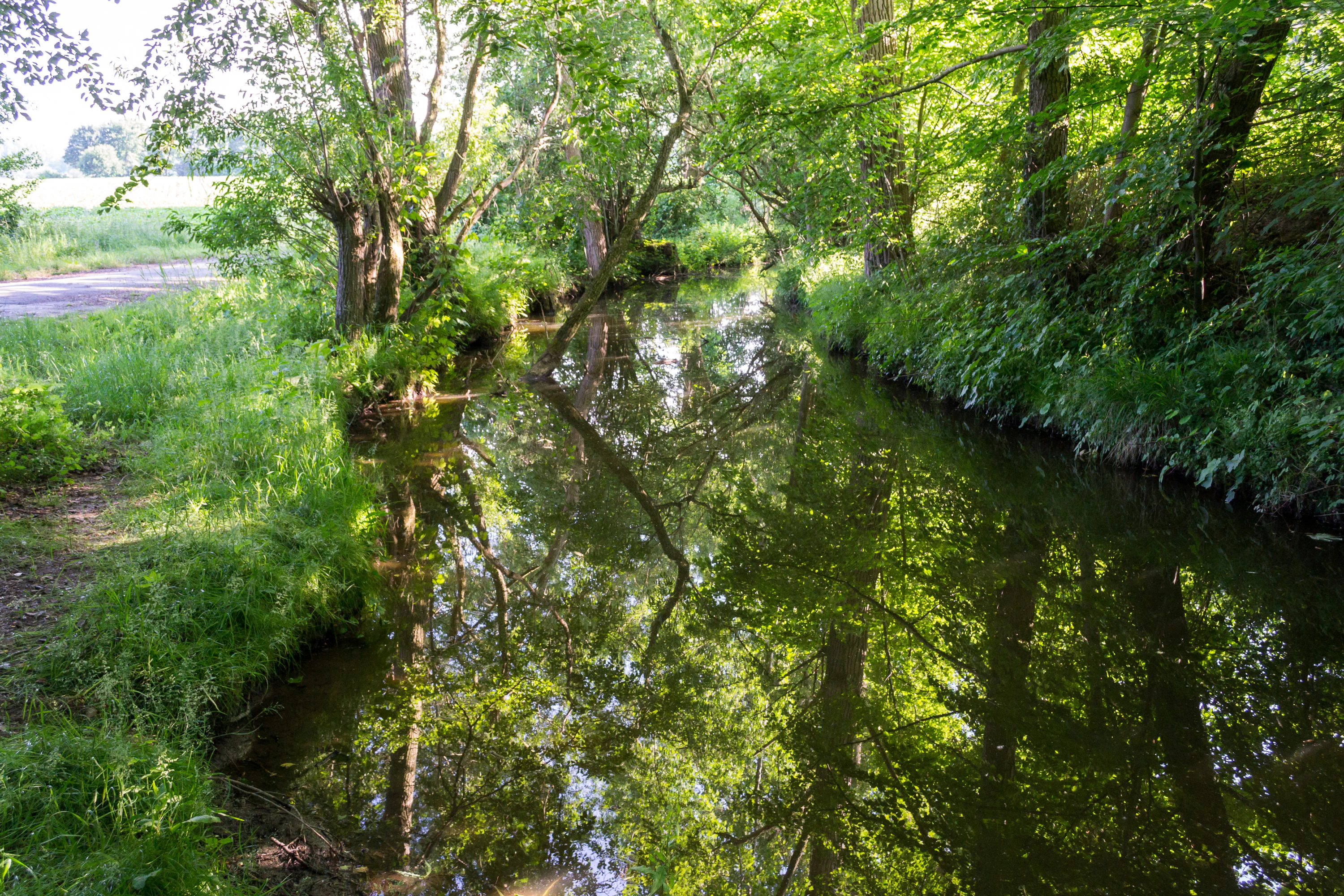
A calm, narrow stream flows through a lush, green forest with sunlight filtering through the dense canopy, creating reflections on the water surface.
The Windwehe stream flowing through the forested landscape of the Windwehetal nature reserve.

Windwehetal history and protected-area timeline

Windwehetal was formally designated as a Naturschutzgebiet in 1998 by the regional authorities of North Rhine-Westphalia, in response to its ecological value as a near-natural brook valley. Its protection was coordinated through the landscape planning process of Kreis Lippe, specifically within the landscape plan covering Leopoldshöhe and northern Oerlinghausen, which grouped the area into a broader network of nearby nature reserves such as Grüte and Heipker See.

From the outset, the reserve was conceived not as an isolated patch but as a node within a larger green corridor along the Windwehe stream. The neighbouring Windweheniederung reserve on the Bielefeld side of the stream was already in place, and the surrounding Landschaftsschutzgebiet Windwehetal und Seitentäler extends the protective buffer eastward along the side valleys. Administration of the area is handled by the Untere Landschaftsbehörde (lower landscape authority) of Kreis Lippe, which continues to oversee habitat management, visitor guidance, and integration with regional conservation planning.

Windwehetal landscape and geographic character

The landscape of Windwehetal is shaped by a comparatively narrow but deep brook valley that descends into the surrounding North Rhine-Westphalian countryside. The Windwehe stream has carved pronounced Prall- und Gleithänge, undercut and slip-off banks reaching up to three metres in height, creating an undulating valley floor with steep erosional scarps on the outer bends and gentler slip-off slopes on the inner curves. These banks shift over time as the brook continues to rework its own course, lending the valley a visibly dynamic geomorphological character.

Flanking the channel, the terrain steps up into typical side ravines, the Seitensieke, which cut shallow, often boggy corridors into the valley slopes. Where the slope eases and groundwater emerges, the land flattens into damp depressions and seepage hollows, while along the valley's upper edges the land rises into drier, more beech-dominated slopes. This vertical gradient, from wet brook bottom to drier beech ridge, gives Windwehetal a strong sense of topographic layering despite its limited size.

Windwehetal ecosystems, habitats, and plant life

Ecologically, Windwehetal falls into the classic Westphalian category of a near-natural lowland brook valley, with habitats organised around the gradient between flowing water and the surrounding slopes. The valley bottom is dominated by Bach-Erlen-Eschenwald, an alder-ash floodplain woodland that forms continuous gallery strips along the brook, while the lower slopes carry erlenreiche Stieleichen-Hainbuch-Wälder, alder-rich oak-hornbeam stands with a high water table.

Between these wooded communities, open and semi-open habitats punctuate the valley: patches of feuchtes Grünland (wet grassland), reed-like stands of Rohrglanzgras, and areas of Weidegebüsche, willow scrub that colonises the active slip-off banks. On the drier upper slopes and along the eastern margin, a mature Buchhochwald (high beech forest), partly enriched with oak, provides the contrast of a shady, structurally uniform upland forest, while small, structurally rich Feldgehölze, field copses, fringe the valley edges. The result is a tight mosaic of hydrological, wetland, and forest habitats packed into a comparatively small area.

Windwehetal wildlife and species highlights

Windwehetal's wildlife value is closely tied to its habitat diversity: the alternating pattern of brook, seepage hollows, dense gallery woodland, and high beech forest supports very different animal communities within a short distance. In the brook and the alder-ash gallery forests, the wet conditions and leaf-litter habitat favour amphibians, stream insects, and moisture-dependent bird species, while the willow scrub on the active slip-off banks provides nesting cover for shrub-loving songbirds.

The adjoining oak-hornbeam and beech forests offer sites for cavity-nesting and woodland species, and the transition zones between open wet grassland and closed canopy are particularly important for invertebrates and edge-loving birds. Because the reserve sits within a larger protected landscape complex along the Windwehe and connects to the neighbouring Windweheniederung, it also functions as a stepping stone for species moving along the stream corridor.

Windwehetal conservation status and protection priorities

From a conservation perspective, Windwehetal matters less for its size than for its integrity: it preserves a near-natural, continuously reshaping brook valley, including the undercut banks and seepage slopes whose disturbance dynamics are themselves the ecological engine of the site. The presence of well-developed alder-ash floodplain woodland, alder-rich oak-hornbeam forest, and high beech forest on adjacent slopes makes the reserve a compact representation of the gradient between wet and dry forest habitats that is increasingly fragmented in the surrounding region.

By linking directly with the Windweheniederung reserve on Bielefeld territory and with the surrounding Landschaftsschutzgebiet Windwehetal und Seitentäler, Windwehetal also plays a structural role in the regional conservation network along the Windwehe stream corridor. Its IUCN Category IV status emphasises that it is managed primarily to maintain specific habitats and species rather than as a strict wilderness area, and its establishment in 1998 reflects the broader NRW strategy of securing representative, ecologically dynamic valley landscapes across Kreis Lippe.

Windwehetal cultural meaning and human context

The Windwehe valley lies within a long-settled rural landscape on the edge of the Teutoburg Forest, where small streams and side valleys have traditionally supported streamside meadows, small woodlands, and mixed agricultural land use. The protected area spans parts of the Leopoldshöhe sub-districts of Bechterdissen, Greste, and Schuckenbaum, communities whose names and field patterns reflect a centuries-old relationship with this gently incised terrain. While the reserve itself is framed primarily in ecological rather than cultural terms, its value lies in preserving one of the characteristic stream valleys of this historically agrarian part of Lippe.

Top sights and standout views in Windwehetal

A compact 56.5-hectare protected brook valley with a highly dynamic Windwehe stream and undercut banks up to three metres high. A rare tight mosaic of alder-ash gallery forest, oak-hornbeam stands, willow scrub, wet grassland, and high beech forest within a single protected area. A key link in the ecological chain formed by the Windweheniederung reserve on the Bielefeld side and the Windwehetal und Seitentäler protected landscape to the east. A textbook example, in NRW conservation terms, of the protected brook-valley landscape type recognised under IUCN Habitat/Species Management Area status.

Best time to visit Windwehetal

Because Windwehetal is valued primarily for its forest and stream habitats rather than spectacular vistas, the experience changes most clearly with the seasons through the appearance of the woodland and the activity of the brook. Late spring and early summer bring fresh green foliage to the beech and oak-hornbeam stands and active bird song along the valley edges, while damp conditions highlight the seepage hollows, willow scrub, and the wet grassland patches beside the brook.

In autumn, the beech high forest on the upper slopes takes on strong autumn colour, and the contrast with the still-green alder gallery strips along the stream becomes especially vivid. Winter visits tend to be quieter and showcase the dynamic stream profile most clearly, when leafless trees expose the steep undercut banks, side ravines, and shifting course of the Windwehe. Detailed access and weather-sensitive timing should be checked against current local guidance rather than assumed.

Monthly climate preview

Long-term representative monthly temperature and precipitation data for Windwehetal

Windwehetal Climate Normals and Annual Temperature Rhythm

Windwehetal exhibits a measured annual temperature and precipitation rhythm derived from long-term representative coordinate records spanning monthly means from near freezing to warm maximums. Exploring the complete twelve-month climate profile reveals deeper historical variations across every recorded period.
Annual mean9 °C
1 °C18 °C
Jan
Feb
Mar
Apr
May13°
Jun16°
Jul18°
Aug18°
Sep14°
Oct
Nov
Dec
Warmest month
July

18.1 °C

Coolest month
January

0.5 °C

Wettest month
December

2.6 mm/day

Driest month
April

1.6 mm/day

Park location guide

Geography guide, regional context, and park location map for Windwehetal

Windwehetal park geography, regions, and map view in Germany

Understand where Windwehetal sits in Germany through a broader geographic reading of the surrounding landscape, nearby location context, and its mapped position within the national park landscape.

How Windwehetal fits into Germany

Germany is a federal republic in Western and Central Europe with a population of over 83 million across sixteen constituent states. It is Europe's largest economy by nominal GDP and a major global exporter and importer. The capital is Berlin, and the country borders Denmark, Poland, Czech Republic, Austria, Switzerland, France, Luxembourg, Belgium, and the Netherlands.

Wider geography shaping Windwehetal in Germany

Germany is located in Western and Central Europe, spanning 357,022 km². It borders Denmark to the north, Poland and the Czech Republic to the east, Austria and Switzerland to the south, and France, Luxembourg, Belgium, and the Netherlands to the west. The country has coastlines on the Baltic Sea and North Sea to the north, with the Alps located in the southern region.

Map view of Windwehetal

Use this park location map to pinpoint Windwehetal in Germany, understand its exact geographic position, and read its mapped placement within the surrounding landscape more clearly.

Pigeon | © OpenStreetMap contributors

Location context for Windwehetal

Nordrhein-Westfalen

Explore photographic records of forest communities, stream dynamics, and valley terrain.

Windwehetal Landscape Photos and Scenery, Visualizing the Protected Brook Valley

Photographic documentation reveals the intricate topography of the protected brook valley, detailing undercut stream banks and wooded ravine slopes. Visual reference materials map out the vegetation mosaic from wet floodplain forests to dry beech ridges across the terrain.

A calm, narrow stream flows through a lush, green forest with sunlight filtering through the dense canopy, creating reflections on the water surface.

Park atlas

Discover adjacent protected areas and regional valley reserves across North Rhine-Westphalia

Other Parks Near Windwehetal and Related Protected Landscapes to Compare Next

Browsing parks near Windwehetal reveals connected valley habitats and broader regional conservation networks across the Lippe district. Comparing adjacent protected landscapes helps trace similar stream dynamics and woodland corridors throughout the surrounding terrain.
Nature reserveNordrhein-Westfalen
About 1.7 km away#1 closest

Northwest

Windweheniederung Nature Reserve: Geographic Atlas of an East Westphalian Floodplain

Riparian ecosystems and protected valley land mapping

Windweheniederung represents a specialized nature reserve in Nordrhein-Westfalen that centers on the natural morphology of the Windwehe stream. This protected area provides a critical refuge for wetland-dependent species through its alder-ash woodland and reed-fringed pools. Explore the structural geography of this lowland catchment and understand its role in maintaining functional floodplains amidst a heavily developed regional environment.

Area
0.297 km²
Established
1991
IUCN
IV
Watercolor illustration showing a calm lake surrounded by green trees and vegetation with rolling hills and a pink sky in the background
Nature reserveNorth Rhine-Westphalia
About 5.1 km away#2 closest

Northeast

Heipker See Nature Reserve: Geographic Mapping of the Werre River Valley Landscape

Protected riparian habitat in North Rhine-Westphalia, Germany

Heipker See offers a detailed look into the landscape composition of an eastern Westphalian nature reserve. The protected area features a distinct concentration of stillwater, stream, and river-corridor habitats, providing essential space for migratory birds and demonstrating the ecological significance of small-scale landscape connectivity in the Werre valley region.

Area
0.246 km²
Established
1998
IUCN
IV
Relief
Lowland
A pale, soft-toned watercolor painting of a rolling landscape with green fields, forested areas, and a small winding stream under a light sky.
Nature reserveNordrhein-Westfalen
About 5.7 km away#3 closest

East

Holzhauser Bruch Nature Reserve: Protected Wetland and Riparian Geography in Nordrhein-Westfalen

Mapping lowland bog and meandering river corridors

Holzhauser Bruch in Nordrhein-Westfalen preserves a compact yet ecologically vital riverine landscape. Its terrain contrasts wet alder-dominated swamp forests with drier, sandy upland slopes. This summary explores the geographic boundary of the reserve, highlighting its role as a representative fragment of the Werre valley habitat system.

Area
0.4 km²
Established
2002
Watercolor painting of a green, rolling landscape with trees and soft hills, rendered in a minimalist, light-toned style on a white background.
Nature reserveNordrhein-Westfalen
About 9.5 km away#4 closest

Northeast

In der Masch Nature Reserve: Mapped Floodplain Geography in Nordrhein-Westfalen

Protected nature reserve with rare lowland meadow habitats.

In der Masch offers a focused look at protected lowland river-meadow terrain within Germany. This 23-hectare nature reserve in Nordrhein-Westfalen protects interconnected oat-grass grasslands, riparian wood fringes, and historical boundary markers, providing a distinct study in regional floodplain topography and habitat preservation.

Area
0.23 km²
Established
2002
IUCN
IV
A watercolor painting of a wetland landscape with soft green hills, trees, and a winding waterway.
Nature reserveNorth Rhine-Westphalia
About 12 km away#5 closest

South

Kipshagener Teiche Nature Reserve: A Protected Wetland Sanctuary in North Rhine-Westphalia

Geographic analysis of historic bogs and managed wetland habitats

Kipshagener Teiche is a small but essential nature reserve in the Senne region, characterized by a distinct mosaic of ponds, transitional bog, and wet heath. Originally protected in 1937, the site serves as a vital record of wetland biodiversity and recovery in western Germany. Its varied topography, featuring dune-based pine plantations and swamp forest, offers a precise look at the intersection of conservation and landscape management in a human-influenced region.

Area
0.113 km²
Established
1970
IUCN
IV
A horizontal watercolor painting showing a small winding river flowing through a lush green forest with soft pink and yellow meadow areas in the foreground.
Nature reserveKreis Gütersloh
About 13 km away#6 closest

Southwest

Holter Wald Nature Reserve: Mapping the Protected Woodland and Senne Landscape of Kreis Gütersloh

A major contiguous forest block on the eastern edge of the Westfälische Bucht

Situated in the district of Kreis Gütersloh, Holter Wald is a significant protected area defined by its sandy Senne soils and network of parallel brook valleys. The forest provides a critical lowland habitat for diverse flora and fauna, serving as a rare, large-scale woodland anchor within a largely agricultural region. Explore the terrain characteristics and ecological structure of this key North Rhine Westphalia site.

Area
6.13 km²
Established
2008
IUCN
IV
Relief
Lowland
A watercolor painting showing a soft, peaceful landscape with bare trees in the foreground, green trees in the midground, and distant hills under a pale sky.
Nature reserveNorth Rhine-Westphalia
About 13 km away#7 closest

Southwest

Kampeters Kolk Nature Reserve: Geographic Overview and Protected Wetland Boundaries

Senne region heath pond and wetland mosaic in North Rhine-Westphalia

Kampeters Kolk preserves a significant fragment of the historic Senne heath landscape in North Rhine-Westphalia. The reserve centers on a small, artificial pond created by peat extraction, now surrounded by a rich sequence of sedges, reed stands, and willow-alder shrub thickets that provide critical habitats for local amphibian populations.

Area
0.02 km²
Established
1993
IUCN
IV
A watercolor painting showing a stylized landscape with rolling green hills, a winding path or stream, and distant purple mountains against a white background.
Nature reserveNorth Rhine-Westphalia
About 16 km away#8 closest

East

Ilse Nature Reserve: Protected Stream Corridor and Floodplain Geography in North Rhine-Westphalia

Mapped riparian habitats and regional conservation landscape context.

Ilse Nature Reserve serves as a critical protected corridor within the Lippe district, spanning five distinct sections along the Ilse stream. The reserve is defined by its near-natural watercourse, wet meadows, and traditional orchard remnants that safeguard species-rich habitats. This geographic focus provides essential insights into the conservation of lowland stream ecosystems and their role in maintaining the ecological connectivity of the broader Bega river valley.

Area
0.142 km²
Established
2009
IUCN
IV
Relief
Upland

Common questions about visiting, size, designation, and location context for Windwehetal

Windwehetal FAQs for park facts, access, geography, and protected area context

Find quick answers about Windwehetal, including protected-area facts, park geography, trail and visitor context, and how the park fits into its surrounding country and regional landscape.
MoriAtlas Explorer

Continue Your Protected Areas Search Across the Global Atlas

Deepen your exploration by continuing the structured search for national parks and protected areas worldwide. Utilize the comprehensive filtering capabilities to compare different conservation landscapes and refine your understanding of global park geography. Discover more about the distribution and characteristics of protected natural areas.

Global natural geography