Mori Atlas logo
Nature reserveWitte Veen

Exploring the ecological boundaries and terrain of a cross-border Dutch peatland restoration site

Witte Veen Nature Reserve and Protected Raised Bog Landscapes in Eastern Overijssel, Netherlands

Witte Veen represents one of the final remaining fragments of a once-extensive raised bog landscape situated along the border of the Dutch province of Overijssel and Germany. This nature reserve, characterized by its wet heath, reed-fringed pools, and bog woodland, functions as a critical component of a wider protected network aimed at restoring connectivity between fragmented peatland ecosystems. Through its status as a Natura 2000 site, the area preserves specialized flora and fauna, including rare dragonflies and migratory birds, within the unique geographical context of the eastern Netherlands.

raised bogpeatlandwetlandNatura 2000conservation areaheath

Witte Veen

Nature reserve

Park overview

Structured park overview, official facts, and landscape profile for Witte Veen

Witte Veen park facts, protected area profile, and essential visitor context

Review the core facts for Witte Veen, including designation, size, terrain, visitor scale, habitats, and operating context in one park-focused overview.

About Witte Veen

Witte Veen sits in the gently rolling border country of eastern Overijssel, where the Netherlands meets the German state of North Rhine-Westphalia. Its position on the frontier between two countries is more than a line on a map, as the area's history of peat cutting, boundary disputes, and smuggling has left a distinctive imprint on the landscape and on local place names. Today the area is valued primarily as a surviving piece of raised bog and bog-edge habitat within a region where most of the original peatlands have long since been drained or exploited.

The reserve extends across roughly 100 hectares, of which about 40 hectares are recognised as active bog habitat. The protected Natura 2000 zone, designated on 4 May 2013, covers a larger footprint of 294 hectares that includes surrounding buffer landscape and transitional habitats. The site is managed by the Dutch nature conservation organisation Natuurmonumenten alongside private landowners, with management techniques including large-scale grazing by Scottish Highland cattle, a method widely used in Dutch conservation areas to maintain open landscape conditions and discourage scrub encroachment.

Ecologically, Witte Veen is a wet, peatland-dominated reserve interspersed with heath, bog pools, woodland margins, and reed-fringed edges. Its combination of habitats supports a community of species typical of this kind of bog-and-heath landscape, ranging from amphibians and dragonflies to breeding and migratory birds, and a pollinator fauna of considerable interest for a relatively small site.

The area is also notable within the wider Dutch network of Natura 2000 sites because of its geographical relationship to neighbouring reserves. Together with the Aamsveen to the north and the Haaksbergerveen close by, it represents one of the last pieces of a once much larger raised bog complex. Active conservation planning aims to improve ecological functioning across this mosaic of sites, making Witte Veen an important node in regional peatland recovery efforts rather than an isolated fragment.

Quick facts and research context for Witte Veen

Witte Veen is a Dutch nature area of about 100 hectares, with roughly 40 hectares of raised bog, located on the Overijssel-German border south of Enschede within the municipality of Haaksbergen. The site is privately and publicly managed by Natuurmonumenten and individual landowners, and was formally designated as a Natura 2000 area on 4 May 2013, with the protected zone covering 294 hectares. It is classified as a raised bog habitat site under the European Habitats Directive and forms part of the broader chain of border-region peatland remnants that includes the Aamsveen and Haaksbergerveen.

Protection and recognition

Documented terrestrial protection history and international recognition

Witte Veen Protection Status and International Recognition Data

Witte Veen features verified terrestrial protection status established in 2013 alongside documented Natura 2000 recognition records. Structured administrative entries outline the conservation framework and official designation history for the protected area.

International recognition

Protection details

Protection scope
Terrestrial
Designated year
2013
Transboundary protection
Yes
Park context

Deeper park guide and search-rich context for Witte Veen

Witte Veen history, landscape, wildlife, and travel context

Explore Witte Veen through its history, landscape character, ecosystems, wildlife, conservation priorities, cultural context, and seasonal travel timing in a structured park guide built for atlas discovery and search intent.

Why Witte Veen stands out

Witte Veen is best known as a remnant of the once extensive raised bogs that characterised the Dutch-German border area, and as a habitat for species closely tied to wet peatland and heath environments. The site is recognised for its populations of European tree frogs, a migratory bird interest centred on cranes, the presence of the rare high-moor dragonfly, and a notable assemblage of wild bee species that includes red-list taxa. Equally important is its role within a network of fragmented peatland reserves. Conservation work here is aimed not only at preserving the surviving bog itself but at improving ecological links with neighbouring sites such as the Aamsveen and Haaksbergerveen, so that the wider raised bog complex can recover as a more functional whole.
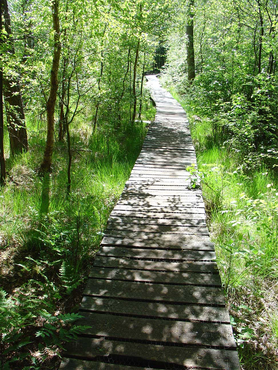
A narrow wooden boardwalk path curves slightly into a dense forest with dappled sunlight on the ground.
A wooden boardwalk winding through the wooded environment of the Witte Veen nature reserve.

Witte Veen history and protected-area timeline

Witte Veen's history is closely intertwined with the history of the Dutch-German border. For centuries the area sat in a frontier zone where peat cutting, small-scale agriculture, and cross-border trade shaped local life. Its position made it a favoured route for smugglers, a heritage still visible in the name of the Twistveenweg that runs along the boundary, a reminder of times when the line between the two countries was less clearly drawn than it later became. Eighteenth-century border markers in the area recall the gradual fixing of the frontier through cartography and boundary stones.

In modern conservation history, the area underwent a transformation from a landscape exploited for peat to one managed for ecological recovery. Natuurmonumenten, one of the largest nature conservation organisations in the Netherlands, took on the management of the site, and large herbivores in the form of Scottish Highland cattle were introduced to help maintain the open conditions that the bog and heath habitats require.

The most significant recent milestone came on 4 May 2013, when Witte Veen was formally designated as a Natura 2000 area under the European Habitats Directive. This designation placed the site within the European Union's network of protected nature areas and recognised both its remaining bog habitat and its broader importance as part of the peatland landscape of the Dutch-German border region.

Witte Veen landscape and geographic character

The landscape of Witte Veen is shaped by its peatland origins. Despite extensive historical peat cutting, the surviving terrain still reads as a soft, low-lying mosaic of bog, wet heath, reed-fringed pools, and bog woodland edges. The ground is largely flat to gently undulating, with no dramatic relief, but it has a quiet, waterlogged character typical of raised bog remnants, where small changes in water level translate into very different plant communities across short distances.

Visitors encounter the reserve through a network of footpaths that include boardwalks across the wettest sections, allowing close access to the bog while protecting fragile peat from trampling. The combination of open peat surface, scattered bog pools, and surrounding dry heath gives the area its distinctive appearance.

Around the edges of the bog proper, the landscape transitions into mixed habitats. There are borders of birch and oak woodland, patches of dry heath, and small grasslands that together form a buffer around the core wet area. The sense of the landscape extends beyond the reserve itself into the rolling border country of eastern Overijssel and the adjacent German frontier, with farmland, small woodlands, and quiet rural roads between the protected fragments.

Witte Veen ecosystems, habitats, and plant life

Witte Veen's ecological identity is defined by its surviving raised bog habitat and the mix of bog, wet heath, and woodland margin habitats that surround it. The bog core is the most ecologically valuable component, supporting plant communities adapted to nutrient-poor, acidic, and waterlogged conditions, while the surrounding heath and woodland edges provide transitions that are themselves important for many of the species associated with the area.

Because most regional peatlands have been drained, the recovery and protection of bog habitat here has wider ecological significance. Active management aims to maintain and gradually restore the hydrology of the area, since the condition of a raised bog is closely tied to consistent water levels and to the prevention of drying and scrub encroachment.

The reserve also contributes to national-level conservation efforts for several rarer habitat types and species. Its combination of bog, heath, and bog-edge woodland gives it a habitat diversity that, within a relatively compact area, supports a range of organisms that would each typically require a larger landscape if the habitats were found in isolation.

Witte Veen wildlife and species highlights

Wildlife is one of the most distinctive features of Witte Veen, particularly given the relatively small size of the protected zone. The bog habitat supports species strongly associated with peatland environments, including the rare high-moor dragonfly, a dragonfly species tied closely to intact raised bog conditions and considered an indicator of habitat quality.

Amphibians are another important group here, with the European tree frog being a particularly notable presence. Once in decline, the tree frog population in the reserve has been recovering, and the species is regarded as one of the key conservation successes of the area.

Birdlife at Witte Veen includes both breeding species typical of bog and heath and seasonal visitors. During autumn migration, cranes are regularly observed passing through or feeding in the area, a striking sight that reflects the broader importance of the border region as a flyway. The mix of wet and dry habitats also supports a community of more common bog and heathland birds.

Pollinators are well represented for such a small site. Thirty-one bee species have been recorded in Witte Veen, three of which appear on the Dutch Red List of threatened bee species: the sporkehoutzandbij, heidezandbij, and bosbloedbij. The presence of several red-listed bees underlines the disproportional value of small, well-managed peatland sites for insect conservation.

Witte Veen conservation status and protection priorities

Witte Veen is protected as a Natura 2000 area under the European Habitats Directive, a designation that reflects the international conservation significance of its surviving raised bog habitat. The site was officially designated on 4 May 2013, and the protected zone covers 294 hectares, larger than the core reserve itself, in order to include surrounding buffer habitat that is important for the long-term survival of the bog.

Conservation management is led by Natuurmonumenten, the Dutch nature conservation society, in cooperation with private landowners. Grazing by Scottish Highland cattle is used as a key tool to keep the landscape open, prevent tree encroachment onto the bog surface, and maintain the mix of bog, heath, and grassland that characterises the area. Boardwalks and marked paths help to focus visitor pressure while protecting fragile peat soils from damage.

A central element of the longer-term conservation vision is connectivity. Witte Veen, Aamsveen, and Haaksbergerveen together represent surviving pieces of a much larger former raised bog. Efforts are underway to strengthen ecological links between these sites so that the wider peatland complex can function more effectively, benefiting species that require larger and more connected bog landscapes than any single fragment can offer.

Witte Veen cultural meaning and human context

The cultural context of Witte Veen is closely tied to its position on the Dutch-German border. For centuries this was a frontier where livelihoods depended on the peatlands themselves, on small-scale farming on poorer sandy soils, and on cross-border trade that at times blurred into smuggling. The name Twistveenweg, along which the boundary runs, preserves the memory of those disputes and of a time when the precise line between the two countries was not yet firmly fixed.

Physical reminders of this borderland past survive in the landscape, including eighteenth-century border stones and historical boundary maps that document the gradual fixing of the frontier. These features give the area an additional layer of significance beyond its natural history value.

Today the area is appreciated primarily as a conservation landscape and a place for quiet recreation, walking, and nature observation. Its identity blends ecological value, a sense of borderland history, and the more recent story of peatland restoration, making it a place where natural and cultural heritage overlap.

Top sights and standout views in Witte Veen

Witte Veen combines a relatively small but ecologically rich raised bog with strong conservation management and a distinctive borderland setting. Its highlights include the surviving bog core and its associated dragonfly and amphibian fauna, the recovery of the European tree frog population, regular crane observations during autumn migration, and a remarkable assemblage of wild bee species that includes several red-listed taxa.

Equally significant is the area's role within the wider Dutch Natura 2000 network. As part of a chain of peatland sites along the Overijssel-German frontier, Witte Veen is at the centre of efforts to reconnect surviving bog fragments, ensuring that its conservation value extends beyond its own boundaries into the regional peatland landscape.

Best time to visit Witte Veen

Witte Veen can be visited throughout much of the year, but the character of the experience shifts with the seasons. Spring and early summer are often the most rewarding periods for observing dragonflies around bog pools, listening for amphibians, and seeing the reserve's flowering plants and heath at their most active.

Autumn brings a different kind of interest, when migratory cranes can be observed passing through or feeding in the area, often in loose flocks calling overhead. The cooler, damper conditions of autumn and early winter can also bring out the wet, atmospheric quality of the bog itself, while summer evenings may offer good chances to hear wetland birds and amphibians along the bog edges. Winter visits offer a quieter, more contemplative atmosphere with reduced insect and amphibian activity but clearer views across the open landscape.

Monthly climate preview

Long term annual temperature ranges and precipitation rhythm for Witte Veen

Witte Veen Climate Normals and Average Temperature Patterns

Representative point measurements establish the baseline annual temperature and precipitation rhythm across twelve recorded intervals at Witte Veen. Exploring the complete monthly climate normals reveals detailed longitudinal temperature averages and daily precipitation trends.
Annual mean10 °C
2 °C18 °C
Jan
Feb
Mar
Apr
May13°
Jun16°
Jul18°
Aug18°
Sep15°
Oct10°
Nov
Dec
Warmest month
July

18.4 °C

Coolest month
January

1.6 °C

Wettest month
December

2.5 mm/day

Driest month
April

1.5 mm/day

Park location guide

Geography guide, regional context, and park location map for Witte Veen

Witte Veen park geography, regions, and map view in Netherlands

Understand where Witte Veen sits in Netherlands through a broader geographic reading of the surrounding landscape, nearby location context, and its mapped position within the national park landscape.

How Witte Veen fits into Netherlands

The Netherlands is a low-lying coastal country in Northwestern Europe, famous for its extensive dike and canal systems that reclaim land from the sea. It consists of twelve provinces and is known for tulips, windmills, and cycling culture. The country is a founding member of the European Union with Amsterdam as its capital and The Hague as the seat of government.

Wider geography shaping Witte Veen in Netherlands

The Netherlands is located in Northwestern Europe along the North Sea coastline to the north and west. It borders Germany to the east and Belgium to the south. The country is notably flat, with a significant portion of its territory lying below sea level, protected by dikes and dune systems. It consists of twelve provinces and also includes overseas municipalities in the Caribbean.

Map view of Witte Veen

Use this park location map to pinpoint Witte Veen in Netherlands, understand its exact geographic position, and read its mapped placement within the surrounding landscape more clearly.

Pigeon | © OpenStreetMap contributors

Location context for Witte Veen

Overijssel
Recorded earthquake history

Review Recorded Earthquake History and Seismic Records for Witte Veen

Consult the historical catalog of recorded seismic events associated with the location of Witte Veen. MoriAtlas provides structured access to event details, helping users observe recorded ground movement patterns through documented geographic data near this protected wetland.

Witte Veen Earthquake History

Catalogued events

2 events

Strongest magnitude

Magnitude 3.6

Most recent event

May 9, 2003

This history includes earthquakes recorded inside the park or within 50 km of its borders

Explore protected area views, bog pools, and wetland terrain across the borderland reserve.

Witte Veen Photos and Landscape Scenery: Visualizing the Raised Bog Habitat

Visual records capture the distinctive character of the surviving peatland mosaic, highlighting wet heath, reed-fringed pools, and woodland edges. Examining photographic documentation helps clarify the terrain, conservation scope, and environmental diversity defining the protected reserve.

A narrow wooden boardwalk path curves slightly into a dense forest with dappled sunlight on the ground.

Park atlas

Compare connected peatland reserves and nearby cross border conservation areas

Exploring Other Parks Near Witte Veen and Surrounding Protected Landscapes

Browsing other parks near Witte Veen reveals connected wetland fragments and surviving raised bogs across the border region. Comparing adjacent protected landscapes helps trace regional ecological networks and similar terrain features.
Watercolor painting of a low-lying, marshy landscape with soft green meadows and sparse vegetation against a white background.
Nature reserveNorth Rhine-Westphalia
About 2.8 km away#1 closest

Southwest

Lüntener Fischteiche Nature Reserve: Geography and Protected Area Landscape Map

A preserved mosaic of Münsterland heath and bog ecosystems

Lüntener Fischteiche is a specialized nature reserve in North Rhine-Westphalia, documented here for its distinct heath-pond character and ecological significance within the German-Dutch borderland. The site preserves remnants of bog and heath vegetation embedded within a pine forest matrix, serving as an important hub for regional waterbird populations and transboundary habitat connectivity.

Area
1.011 km²
Established
1959
IUCN
IV
Nature reserveNordrhein-Westfalen
About 12 km away#2 closest

Southwest

Moore und Heiden des westlichen Münsterlandes Nature Reserve: Regional Protected Landscapes

Bog and heathland geography in western North Rhine-Westphalia

The Moore und Heiden des westlichen Münsterlandes nature reserve is a vital complex of peatlands, wet meadows, and bog woodlands situated in western Germany. This site offers a unique geographic study of restored hydrology and open moorland, providing critical habitats for rare waders and the northernmost breeding colony of Greater Flamingo in Europe.

Area
23 km²
Established
1983
A soft, light watercolor painting of a serene marshy landscape with green hills, lush vegetation, and pink flowers in the foreground.
Nature reserveNordrhein-Westfalen
About 12 km away#3 closest

Southwest

Krosewicker Grenzwald Nature Reserve: Protected Woodland and Border Geography Atlas

Münsterland nature reserve with cross-border habitat significance

Krosewicker Grenzwald is a rare island of woodland set within the intensely cultivated agricultural plains of the western Münsterland. This nature reserve, straddling the German-Dutch border, supports specialized birch and pipegrass communities while functioning as a critical component of the broader Natura 2000 conservation framework.

Area
0.074 km²
Established
1985
IUCN
IV
Nature reserveOverijssel
About 13 km away#4 closest

North

Landgoed Lonnekermeer Nature Reserve: Geographic Landscape and Protected Area Mapping

Twente region, Overijssel province, Netherlands

Landgoed Lonnekermeer is a 98 hectare nature reserve in Overijssel characterized by a designed early twentieth century landscape, lakes originating from historic sand quarries, and expansive wet heath. Explore the protected boundaries of this estate as it serves as a living model for habitat restoration, showcasing the successful recovery of local fens, brooks, and biodiversity-rich hay meadows within the eastern Netherlands.

Area
1.05 km²
Established
1902
Relief
Lowland
Climate
Temperate
A soft watercolor painting of a green meadow landscape with a small pond, cattails, and gentle forested hills in the background.
Nature reserveOverijssel
About 18 km away#5 closest

North

Landgoederen Oldenzaal: Mapping the Protected Estate Forests of Overijssel

Nature reserve geography and habitat connectivity in Twente

Landgoederen Oldenzaal comprises a series of historical estates at the foot of the Oldenzaal ice-pushed ridge. The landscape is characterized by mature woodland complexes, spring-fed brooks, and a traditional field pattern that persists today. As a protected Natura 2000 site, it demonstrates successful habitat reconnection through specialized infrastructure within the wider Twente region.

Area
5.78 km²
Established
2013
Relief
Upland
Climate
Temperate
Nature reserveGelderland
About 22 km away#6 closest

Southwest

Korenburgerveen Nature Reserve: Geography and Protected Peatland Landscapes in Gelderland

A vital wetland and raised bog complex in the Dutch Achterhoek

Korenburgerveen represents a key protected peatland basin in Gelderland, featuring a diverse mosaic of marsh woodland, blue grassland, and active raised bog. Use this geographic entry to analyze the reserve's position within the wider Nationaal Landschap Winterswijk and observe the hydrological restoration of its rare wetland terrain.

Relief
Lowland
Climate
Temperate
Scope
Terrestrial
Water
Major water bodies
Nature reserveNetherlands
26 km away#7 closest

South

Wooldse Veen Nature Reserve: Mapped Geography and Protected Bog Landscapes in the Netherlands

A transboundary peatland system in Gelderland.

Wooldse Veen preserves a rare fragment of raised bog and peatland habitat in the Dutch-German borderlands. The reserve features restored bog pools, historic smugglers paths, and a mosaic of heathland and birch woodland that reflects the regional geography of the Winterswijk National Landscape.

Area
1.5 km²
Established
1949
Relief
Lowland
Climate
Temperate
Nature reserveGelderland
26 km away#8 closest

West

Stelkampsveld Protected Nature Reserve and Restored Achterhoek Kampenlandschap in Gelderland

Tracing the mapped boundaries of historic heath and fen ecosystems

Stelkampsveld acts as an ecologically distinctive protected area in the eastern Netherlands. Covering 102 hectares, the terrain showcases a recovered mosaic of hedgerows, small enclosed fields, and re-established wetlands. The site is recognized for its botanical diversity, including rare orchid and moss species within the broader Natura 2000 network of Gelderland.

Area
1.02 km²
Established
2013
Relief
Lowland
Climate
Temperate

Common questions about visiting, size, designation, and location context for Witte Veen

Witte Veen FAQs for park facts, access, geography, and protected area context

Find quick answers about Witte Veen, including protected-area facts, park geography, trail and visitor context, and how the park fits into its surrounding country and regional landscape.
MoriAtlas Explorer

Continue Your Protected Areas Search Across the Global Atlas

Deepen your exploration by continuing the structured search for national parks and protected areas worldwide. Utilize the comprehensive filtering capabilities to compare different conservation landscapes and refine your understanding of global park geography. Discover more about the distribution and characteristics of protected natural areas.

Global natural geography