
Mori Atlas logo
Nature reserveWittsaal

A compact sanctuary of peat-derived moor ponds, swamp woodland, and marsh habitats

Wittsaal Nature Reserve: Mapped Protected Landscapes and Wetland Geography in Lower Saxony

(Naturschutzgebiet Wittsaal)

Wittsaal stands as a significant nature reserve in northern Germany, preserving a complex of aging moor ponds, dense reedbeds, and tall sedge marshes within the agricultural terrain of Lower Saxony. This protected area offers insight into rare, waterlogged habitats that have become increasingly uncommon in the surrounding Lüneburg landscape. Through its quiet mosaic of willow-dominated swamp woodland and gradually silting waterbodies, the reserve functions as a vital anchor for regional wetland ecology and glacial soil topography.

wetlandmoor pondswamp woodlandBruchwaldreedbedsedge marsh
A graphic illustration showing a waterfall flowing over a cliff into a river, surrounded by pine trees and distant hills under a pale sun.

Wittsaal

Nature reserve

Park overview

Structured park overview, official facts, and landscape profile for Wittsaal

Wittsaal park facts, protected area profile, and essential visitor context

Review the core facts for Wittsaal, including designation, size, terrain, visitor scale, habitats, and operating context in one park-focused overview.

About Wittsaal

Wittsaal is a compact but ecologically focused nature reserve in the Lüneburg area of Lower Saxony, in northern Germany. Covering only about 13 hectares, it nevertheless concentrates a striking variety of wetland features within its borders and illustrates how even very small protected areas can preserve habitats that have largely disappeared from the surrounding countryside.

The reserve is situated in the Gemeinde Mechtersen within the Samtgemeinde Bardowick, northwest of the historic city of Lüneburg. Its landscape is low-lying and flat, sitting only about 12 to 13 metres above sea level, and its character is shaped entirely by water. At the heart of the area is a small moor pond, known locally as a Moorweiher, that originated from peat cutting and is now in an advanced stage of natural silting-up. As the open water slowly contracts, wetland vegetation has been advancing inward, blurring the boundary between pond and surrounding marsh.

This pond and its immediate fringe form the ecological core of Wittsaal. The waterbody is bordered by Bruchwald, a type of swamp woodland that develops on waterlogged, peat-rich soils. Here willow shrubs and stands of sweet gale, known in German as Gagel, rise from the saturated ground. Beyond the woodland edge, the reserve extends into more open wetland communities, including Großseggenriede, dense stands of tall sedges, and Röhricht, the classic reedbeds built on robust emergent plants such as reeds and bulrushes. Aquatic vegetation completes the habitat mosaic within the water itself.

Around this core, the reserve includes sections of the surrounding land that are still used for agriculture. These fields are partly subdivided by hedges, providing structural variety and a softer transition between intensively farmed land and the protected wetland. Because the reserve is almost entirely enclosed by additional farmland, Wittsaal functions as an isolated pocket of wetland habitat within an agricultural matrix. This isolation is precisely the reason the area was placed under protection in 1985 and why visitor access is restricted, allowing the site to remain a quiet refuge for its specialised plant communities and the wetland wildlife that depends on them.

Quick facts and research context for Wittsaal

Wittsaal is a Naturschutzgebiet covering roughly 13 hectares in the municipality of Mechtersen, Landkreis Lüneburg, Lower Saxony, northwest of the city of Lüneburg. It has been a statutory nature reserve since 16 September 1985 and carries the official designation NSG LÜ 128, with the Landkreis Lüneburg acting as the responsible lower nature protection authority and the Niedersächsischer Landesbetrieb für Wasserwirtschaft, Küsten- und Naturschutz as the supervising agency. The site lies at a low elevation of about 12 to 13 metres above sea level and is classified internationally as IUCN Category IV, recognizing its role as a habitat and species management area.

Protection and recognition

Examine the terrestrial protection scope and documented designation records for Wittsaal.

Wittsaal Protection Status and International Recognition Details

Wittsaal maintains a documented terrestrial protection profile within the global database alongside established administrative boundaries. Conservation researchers examine these official records to verify baseline protected area attributes and designation histories.

Protection details

Protection scope
Terrestrial
Transboundary protection
No
WDPA ID
166343
Park context

Deeper park guide and search-rich context for Wittsaal

Wittsaal history, landscape, wildlife, and travel context

Explore Wittsaal through its history, landscape character, ecosystems, wildlife, conservation priorities, cultural context, and seasonal travel timing in a structured park guide built for atlas discovery and search intent.

Why Wittsaal stands out

Wittsaal is best known for protecting a small, peat-cut moor pond that is gradually filling in and turning back into wetland. Surrounded by swamp woodland, reedbeds, and tall sedge communities, the reserve exemplifies the kind of nutrient-poor, waterlogged habitat that has become rare in the intensively used agricultural landscapes of the Lüneburg region. The combination of an aging open waterbody, its fringes of willow and sweet gale scrub, and the adjoining aquatic plant communities gives the site a distinctive ecological profile for such a compact reserve. It functions as a quiet local stronghold for bog woodland and marsh habitat within a matrix of farmland.
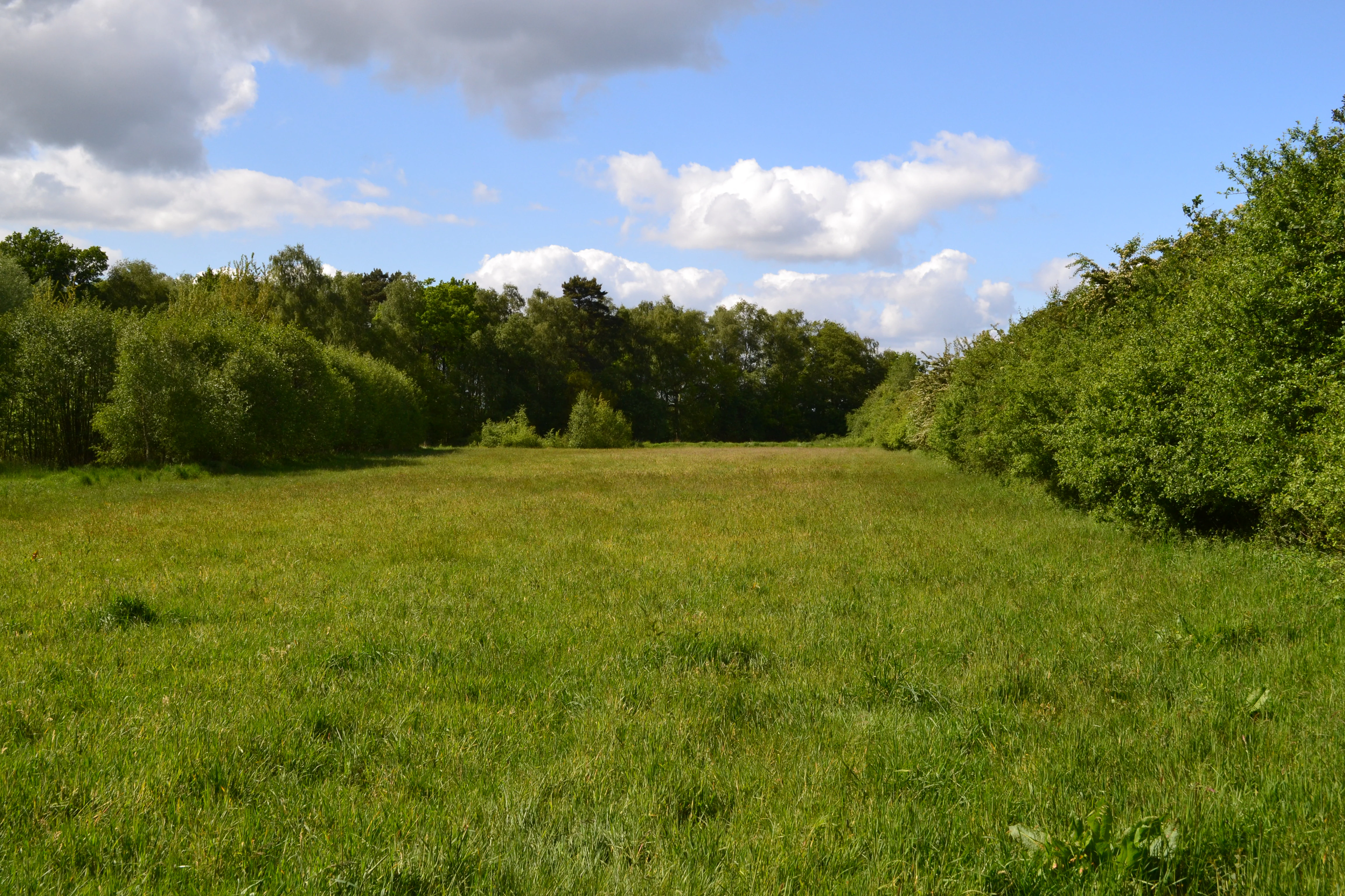
A wide, grassy meadow bordered by dense green trees under a blue sky with scattered clouds.
A view across a meadow at the Wittsaal nature reserve.

Wittsaal history and protected-area timeline

The site that would become Wittsaal has its origins in traditional peat cutting, a form of land use historically common in the wet lowland landscapes around Lüneburg. The removal of peat left behind a shallow pit that filled with groundwater, creating a small moor pond which then began a slow natural process of silting-up and conversion back to wetland as vegetation encroached from the edges.

Recognition of the ecological value of this small, peat-derived wetland habitat came in the 1980s. On 16 September 1985, the area was formally designated as a Naturschutzgebiet under the identifier NSG LÜ 128. Since then, the reserve has been administered under the responsibility of the Landkreis Lüneburg as the lower nature protection authority, with the Niedersächsischer Landesbetrieb für Wasserwirtschaft, Küsten- und Naturschutz serving as the technical state-level agency overseeing water management, coastal protection, and nature conservation in Lower Saxony. The reserve's continuing legal protection and management framework reflect its role as a small but persistent refuge for wetland habitats in an otherwise heavily cultivated landscape.

Wittsaal landscape and geographic character

The landscape of Wittsaal is exceptionally flat and low-lying, defined by the gentle topography of the Lüneburg region in northern Lower Saxony. Elevations across the reserve range only from about 12 to 13 metres above sea level, and the area sits within a wider terrain of mixed farmland and small woodland patches shaped by glacial and post-glacial processes.

The defining feature of the landscape is a small, roughly circular moor pond created by historical peat cutting. Because the surrounding soils are peaty and poorly drained, the pond has never held a steep, defined shoreline; instead, its edges melt gradually into marshy ground. As the pond slowly fills in through natural silting, the open water surface contracts and the wetland margin expands, producing a transitional zone where water, reedbeds, swamp woodland, and wet meadows blend together.

Outside this core, the protected area includes part of the surrounding agricultural land. The fields are largely open but are partly divided by hedgerows, which add structural relief to an otherwise very flat scene. The broader setting beyond the reserve is dominated by additional farmland, so Wittsaal reads visually as a small, green pocket of wetland and woodland set within a working agricultural landscape.

Wittsaal ecosystems, habitats, and plant life

Wittsaal protects a remarkably compact but ecologically layered wetland system. The central feature is a moor pond whose open water is gradually being colonised by aquatic plants as peat-derived sediments accumulate. Around the shoreline, the vegetation grades outward through several distinct zones, each representing a different stage in the transition from open water to drier land.

The first zone surrounds the pond itself, where aquatic plant communities root in the shallow water and contribute to the slow infilling of the basin. Moving outward, reedbeds and tall sedge communities occupy the saturated ground, creating dense, grass-like vegetation that thrives in waterlogged conditions. Beyond these open wetland communities lies the reserve's most characteristic habitat, Bruchwald or swamp woodland, in which willow shrubs and sweet gale, Myrica gale, locally known as Gagel, form the dominant woody cover on permanently wet, peaty soils.

Together, these habitats form a small but complete gradient from open water through reeds and sedges to swamp woodland, an ecologically valuable arrangement because many of the constituent habitat types have become scarce in the intensively farmed landscape of the Lüneburg area. The inclusion of surrounding agricultural land, partially divided by hedges, adds further habitat variety by providing ecotones between open fields and protected wetland.

Wittsaal wildlife and species highlights

The wildlife focus of Wittsaal is closely tied to its wetland character. The mosaic of open water, reedbeds, sedge marsh, and swamp woodland provides habitat for species typical of lowland bogs and ponds in northern Germany, including amphibians, dragonflies, and other invertebrates associated with still, peaty water, as well as bird species that use reedbeds and wet woodland for nesting and feeding.

Because the reserve is small and tightly enclosed by farmland, its value for wildlife lies less in supporting wide-ranging species than in offering a sheltered refuge for wetland-dependent organisms that have lost habitat elsewhere in the intensively used agricultural surroundings. The restricted access, with entry limited to official and scientific purposes, helps maintain the quiet, undisturbed conditions that make the site valuable for sensitive species. The hedges that divide parts of the adjoining farmland add further ecological value by offering cover and movement corridors for small mammals and birds along the reserve's edge.

Wittsaal conservation status and protection priorities

Wittsaal is recognised as an IUCN Category IV protected area, classified as a Habitat or Species Management Area. This designation reflects that the reserve has been set aside specifically to maintain particular habitats and the species associated with them, rather than to allow ecological processes to proceed without intervention.

The core conservation purpose of the site is to protect a small, peat-derived moor pond and its surrounding wetland habitats, including swamp woodland, reedbeds, sedge marsh, and aquatic plant communities. These habitat types have become uncommon across the Lüneburg region as former bogs and wet depressions have been drained and converted to farmland. By safeguarding remaining examples of open water, reeds, and Bruchwald in close proximity, the reserve contributes to regional habitat diversity and helps maintain populations of wetland-dependent species.

Its protected status, formalised in 1985, and its management within the framework of Lower Saxony's nature conservation system, overseen by the Landkreis Lüneburg and the Niedersächsischer Landesbetrieb für Wasserwirtschaft, Küsten- und Naturschutz, ensure that damaging activities are limited. Restrictions on public access protect the sensitive vegetation and wildlife from disturbance, while the inclusion of part of the surrounding farmland within the reserve bounds helps buffer the core wetland from direct impacts of adjacent agricultural practices.

Wittsaal cultural meaning and human context

The wider setting of Wittsaal lies in the historic peatland landscape around Lüneburg, a region where the cutting and burning of peat has long shaped both the economy and the physical appearance of the countryside. The reserve's pond itself is a direct legacy of this older land use, a former peat pit that has been reclaimed by natural processes and converted into wetland habitat.

The surrounding villages and small towns, including Mechtersen and nearby Radbruch, are part of the Samtgemeinde Bardowick, an area with deep historical roots in the Lüneburg Heath region of Lower Saxony. While Wittsaal itself is a strictly protected natural area with limited public access, it sits within a broader cultural landscape of traditional villages, mixed agriculture, and small woodland patches that continues to define life in this part of northern Germany.

Top sights and standout views in Wittsaal

Wittsaal's standout feature is its peat-cut moor pond in an advanced state of natural silting-up, encircled by a compact belt of swamp woodland dominated by willows and sweet gale. The reserve also includes unusually well-developed zones of tall sedge marsh, reedbeds, and aquatic plant communities for an area of its size, set within a working agricultural landscape just northwest of Lüneburg.

Best time to visit Wittsaal

Public access to Wittsaal is restricted by its status as a Naturschutzgebiet, with entry generally limited to the fulfilment of official or scientific duties. As a result, typical seasonal tourism considerations do not apply in the usual way. From a purely observational standpoint, late spring and early summer are typically the most expressive period for wetland reserves of this type in northern Germany, when reedbeds, sedges, and aquatic plants are at peak growth and wetland birds are most active, while autumn can bring rich colour to the swamp woodland edges. Visitors interested in the site are most likely to encounter it from public paths and roads around Mechtersen rather than within the reserve itself.

Monthly climate preview

Long-term temperature and precipitation trends across representative park coordinates

Wittsaal Climate Normals and Measured Monthly Weather Patterns

Wittsaal records measured average temperatures and daily precipitation rates across twelve distinct monthly intervals based on historical NASA data. Examining the complete monthly climate profile reveals specific long-term thermal variations and precipitation rhythms for this protected location.
Annual mean9 °C
1 °C18 °C
Jan
Feb
Mar
Apr
May13°
Jun16°
Jul18°
Aug18°
Sep14°
Oct
Nov
Dec
Warmest month
July

18 °C

Coolest month
January

0.5 °C

Wettest month
July

2.6 mm/day

Driest month
April

1.4 mm/day

Park location guide

Geography guide, regional context, and park location map for Wittsaal

Wittsaal park geography, regions, and map view in Germany

Understand where Wittsaal sits in Germany through a broader geographic reading of the surrounding landscape, nearby location context, and its mapped position within the national park landscape.

How Wittsaal fits into Germany

Germany is a federal republic in Western and Central Europe with a population of over 83 million across sixteen constituent states. It is Europe's largest economy by nominal GDP and a major global exporter and importer. The capital is Berlin, and the country borders Denmark, Poland, Czech Republic, Austria, Switzerland, France, Luxembourg, Belgium, and the Netherlands.

Wider geography shaping Wittsaal in Germany

Germany is located in Western and Central Europe, spanning 357,022 km². It borders Denmark to the north, Poland and the Czech Republic to the east, Austria and Switzerland to the south, and France, Luxembourg, Belgium, and the Netherlands to the west. The country has coastlines on the Baltic Sea and North Sea to the north, with the Alps located in the southern region.

Map view of Wittsaal

Use this park location map to pinpoint Wittsaal in Germany, understand its exact geographic position, and read its mapped placement within the surrounding landscape more clearly.

Pigeon | © OpenStreetMap contributors

Location context for Wittsaal

Lower Saxony

Explore protected area photography highlighting moor pond terrain and swamp woodland environments

Wittsaal Photos and Landscape Scenery: Visualizing Northern Germany Wetland Habitats

Examine detailed imagery showcasing the peat-cut moor pond, reedbeds, and willow swamp woodland that define Wittsaal. Visual documentation reveals the flat agrarian terrain and wetland habitats characteristic of this Lower Saxony nature reserve.

A wide, grassy meadow bordered by dense green trees under a blue sky with scattered clouds.

Park atlas

Compare nearby regional nature reserves and wetland habitats

Explore Protected Areas and Parks Near Wittsaal in Lower Saxony

Browsing parks near Wittsaal reveals a network of low lying wetland reserves and protected landscapes across northern Germany. Expanding the regional view allows travelers to compare similar moor ponds and swamp woodlands within the surrounding agricultural terrain.
Nature reserveLower Saxony
About 9.2 km away#1 closest

East

Streitmoor Nature Reserve Geography and Mapped Protected Land in Lower Saxony

A study in compact bog and wetland succession

Streitmoor provides a detailed look at a terrestrialized pond moor within the Lüneburg district. The site contains a layered sequence of peat mosses, cottongrass, and woodland, mapping the natural transition between open bog basins and dry forest margins in northwestern Germany.

Area
0.13 km²
Established
1972
IUCN
IV
Relief
Lowland
Nature reserveHamburg
About 13 km away#2 closest

Northwest

Zollenspieker Nature Reserve: Geographic Overview and Protected Riverine Landscapes

Tidal Elbe floodplain and inland brack wetland ecology

Located in the Hamburg borough of Bergedorf, Zollenspieker protects a significant stretch of the tidal Elbe. This nature reserve contains approximately 80 hectares of diverse terrain, from freshwater mudflats exposed at low tide to sheltered oak-dominated forests and old brack wetlands known as Carlsbrack and Riepenburger Brack.

Area
0.8 km²
Established
1988
IUCN
IV
Relief
Lowland
Nature reserveLower Saxony
About 17 km away#3 closest

Northwest

Stemmbruch Nature Reserve: Protected Lowland Bog Geography in Lower Saxony, Germany

A resilient moorland habitat near the Seeve floodplain

Stemmbruch serves as a vital nature reserve in the Harburg district, protecting a rare hanging spring bog system. This compact protected area features a mosaic of bog pools, heath, and swamp woodland, demonstrating the complex hydrologic connectivity between the sandy geest ridge and the surrounding northern German lowland plains.

Area
0.56 km²
Established
1989
IUCN
IV
Relief
Lowland
Nature reserveUelzen District
About 21 km away#4 closest

Southeast

Vierenbach Nature Reserve: Landscape Geography and Protected Area Mapping in Uelzen District

A study of lowland stream valleys and swamp forest ecosystems.

Vierenbach serves as a crucial lowland stream sanctuary in the Uelzen District, featuring a concentrated variety of alder and ash swamp forests, birch bog woodlands, and wet fen grasslands. This entry offers a deep look into the reserve's unique transition zones between waterlogged valley floors and drier oak-hornbeam Geest slopes.

Area
2.3 km²
Established
2004
IUCN
IV
Nature reserveLandkreis Uelzen
About 25 km away#5 closest

South

Wettenbosteler Moor Protected Area: Geographic Overview and Mapped Landscape Features

A resilient raised bog remnant in the Landkreis Uelzen heath forest

Spanning roughly thirteen hectares, Wettenbosteler Moor preserves a rare spring-fed bog habitat characterized by peat-forming vegetation and pine forest borders. This nature reserve offers deep insights into the drainage networks and lowland terrain of the Lüneburg Heath, mapping the transition between upland forest and valley mire.

Area
0.128 km²
Established
1977
IUCN
IV
Relief
Lowland
A horizontal watercolor painting depicting a rolling heathland landscape with purple heather, evergreen trees, and a central water feature under a soft sky.
Protected landscapeLower Saxony
About 26 km away#6 closest

Southwest

Naturpark Lüneburger Heide: Protected Landscape Map and Regional Geography

An expansive cultural landscape in northern Lower Saxony

Spanning over 1,000 square kilometers, Naturpark Lüneburger Heide preserves the largest contiguous inland heathlands in Central Europe. Use this atlas resource to understand the park's glacial terrain, including karst sinkholes and natural springs, as well as its status as a model region for sustainable conservation and traditional land management practices.

Area
1,097.85 km²
Established
1922
IUCN
V
Relief
Lowland
A watercolor painting showing a panoramic view of a calm river with a small, vegetated island in the center and pink wildflowers in the foreground.
Nature reserveHamburg
About 27 km away#7 closest

Northwest

Schweenssand Nature Reserve: Protected Elbe Floodplain Geography in Hamburg Germany

Tidal freshwater wetlands, reedbeds, and riverine forest mosaics

Spanning 35 hectares along the Süderelbe, Schweenssand acts as a vital protected area within the Hamburg city boundary. Its geography consists of freshwater tidal flats, mudflats, and ancient-looking floodplain forests that are continuously shaped by the Elbe river tide. This site offers a clear view into the ecological complexity of urban-fringe river landscapes and European Natura 2000 protected zones.

Area
0.4 km²
Established
1993
IUCN
IV
Relief
Lowland
Nature reserveLandkreis Harburg
About 33 km away#8 closest

Northwest

Wulmstorfer Heide mit Bornberg: Protected Nature Reserve and Glacial Landscape Map

Regional geography and habitat network in Landkreis Harburg, Lower Saxony

This protected area features a unique mosaic of dry heath, nutrient-poor grassland, and mature broadleaf woodland. Located near the Hamburg border, it provides an essential habitat refuge within the Harburger Berge, characterized by sandy glacial soils and former military training terrain that supports specialized reptiles, amphibians, and bird species.

Area
2.72 km²
Established
2024
IUCN
IV
Relief
Upland

Common questions about visiting, size, designation, and location context for Wittsaal

Wittsaal FAQs for park facts, access, geography, and protected area context

Find quick answers about Wittsaal, including protected-area facts, park geography, trail and visitor context, and how the park fits into its surrounding country and regional landscape.
MoriAtlas Explorer

Continue Your Protected Areas Search Across the Global Atlas

Deepen your exploration by continuing the structured search for national parks and protected areas worldwide. Utilize the comprehensive filtering capabilities to compare different conservation landscapes and refine your understanding of global park geography. Discover more about the distribution and characteristics of protected natural areas.

Global natural geography