


Mori Atlas logo
Nature reserveWolfslöcher

A detailed atlas examination of fragile bog complexes, alder carr woodlands, and spring-fed rock strata.

Wolfslöcher Nature Reserve: Mapped Protected Landscapes and Regional Geography of the Palatinate Forest

(Naturschutzgebiet Wolfslöcher)

Wolfslöcher represents a critical conservation site within the Südwestpfalz district, showcasing a compact ninety-hectare area defined by diverse microhabitats. This protected landscape contains a unique integration of valley bog vegetation, moisture-rich alder carr, and specialized rock niches formed by the Karlstalschichten geological layers. By tracing the valley axis of the Ransbächel, the reserve preserves essential regional biodiversity within the broader Palatinate Forest terrain.

nature reservebog vegetationalder carrspring nichesKarlstalschichtenPalatinate Forest
A flat-style digital illustration showing a view through tall, silhouetted trees into a valley with a river, coniferous trees, rocky cliffs, and a small waterfall in the distance under a pastel sky.

Wolfslöcher

Nature reserve

Park overview

Structured park overview, official facts, and landscape profile for Wolfslöcher

Wolfslöcher park facts, protected area profile, and essential visitor context

Review the core facts for Wolfslöcher, including designation, size, terrain, visitor scale, habitats, and operating context in one park-focused overview.

About Wolfslöcher

Wolfslöcher is a small but ecologically intense nature reserve in the Palatinate Forest hill country of southwestern Germany. Situated in the Südwestpfalz district of Rhineland-Palatinate, it occupies roughly 90 hectares of forested valley terrain southwest of the village of Lemberg. The reserve lies just south of the L 485 state road and within the broader landscape of the southern Palatinate, a region defined by forested ridges, deeply incised stream valleys, and scattered sandstone geology.

What sets Wolfslöcher apart from typical forested reserves is its concentration of rare, high-specificity habitats confined to small areas. The valley floor contains a transitional bog complex, in which moisture levels, low nutrient availability, and specialized microclimate combine to support bog vegetation and its associated fauna. Around and above the bog, alder carr woodland occupies the wetter parts of the valley, contributing to a multilayered mosaic of wet, moist, and drier woodland types.

The reserve also extends into the flanks of the surrounding terrain, where the Karlstalschichten, a distinct geological layer of the region, create spring niches and rock structural features. These moist, shaded microhabitats are of particular ecological interest because they harbor specialized species that would not survive in the surrounding dry woodland. The overall character of Wolfslöcher is therefore one of small, tightly defined biological communities that depend on very specific geological and hydrological conditions.

Designated under Rhineland-Palatinate conservation law in 1983, the reserve was specifically established to maintain and develop these near-natural to natural communities. The protected area continues to function primarily as a refuge for specialist species and as a reference site for understanding the rare habitat combinations that still exist in this part of the Palatinate Forest.

Quick facts and research context for Wolfslöcher

Wolfslöcher is a nature reserve of about 90 hectares in the Südwestpfalz district of Rhineland-Palatinate, Germany. It was placed under nature protection in 1983 and is administered under Rhineland-Palatinate conservation law. The area sits southwest of the municipality of Lemberg in the southwestern Palatinate Forest landscape, adjacent to the L 485 state road and close to the Salzbach. It is recorded in the World Database on Protected Areas under WDPA ID 166355. Its conservation focus is on bog vegetation, alder carr, spring niches in the Karlstalschichten rock layers, and the small-scale habitats of rare specialist species.

Protection and recognition

Examine documented protection metrics, administrative scope, and official international designations.

Wolfslöcher Protection Status, Designated Area Data, and Records

Wolfslöcher protection status records compile verified administrative data, designation histories, and management frameworks where available. Official database entries catalog baseline conservation attributes, international recognition sources, and formal protected area metrics.

Protection details

WDPA ID
166355
Park context

Deeper park guide and search-rich context for Wolfslöcher

Wolfslöcher history, landscape, wildlife, and travel context

Explore Wolfslöcher through its history, landscape character, ecosystems, wildlife, conservation priorities, cultural context, and seasonal travel timing in a structured park guide built for atlas discovery and search intent.

Why Wolfslöcher stands out

Wolfslöcher is known for its exceptionally specialized and ecologically fragile microhabitats. The reserve protects a transitional bog complex in a narrow valley plain, along with erlenbruch (alder carr) vegetation, and the spring-fed rock niches formed in the Karlstalschichten sandstone. The combination of these small, high-value patches in close proximity gives the site its distinctive conservation significance, as each habitat supports specialist species that are extremely rare and threatened elsewhere.
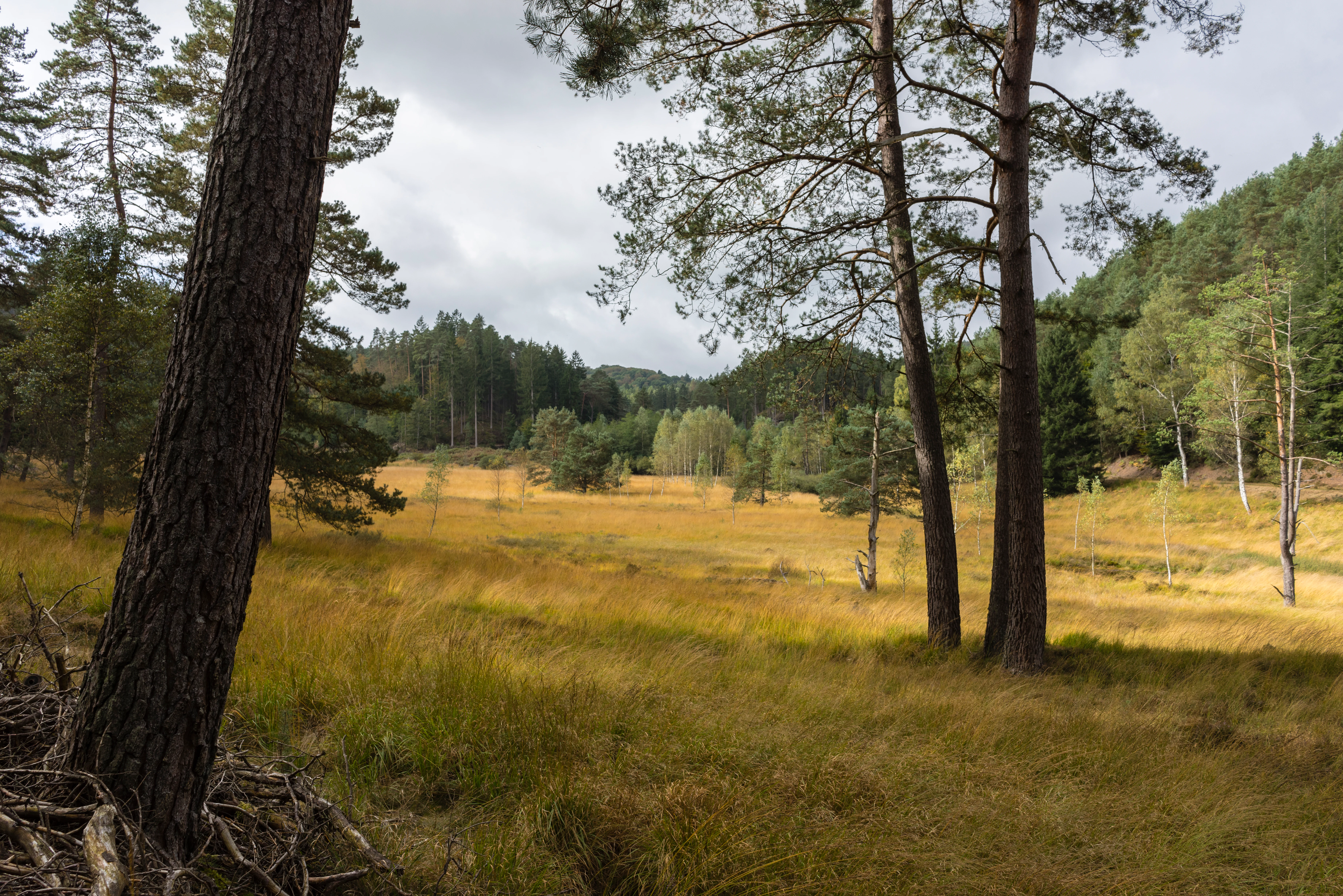
A wide view of a yellow-brown moorland meadow surrounded by tall pine and deciduous trees under a cloudy sky.
Golden moorland vegetation within the valley of the Wolfslöcher nature reserve.

Wolfslöcher history and protected-area timeline

The Wolfslöcher nature reserve was formally designated in 1983 under Rhineland-Palatinate nature protection law, with the original legal ordinance issued on 28 December 1983 by the Landkreis Pirmasens administration. The area was already recognized for its exceptional concentration of rare habitats and specialist species before protection, and its designation reflected concern over the fragility and ecological irreplaceability of its bog, alder carr, and rock niche communities. Since its establishment, the reserve has been managed with the explicit goal of maintaining and developing its natural and near-natural vegetation, and it is documented in national and international databases, including the World Database on Protected Areas.

Wolfslöcher landscape and geographic character

The Wolfslöcher reserve lies in a forested section of the southern Palatinate, where the landscape is shaped by sandstone ridges, narrow valleys, and small perennial streams. The site is traversed by the Ransbächel and the Kleines Ransbächel, which together form the valley axis around which the reserve's habitats are centered. The western flank of the Kleiner Stephansberg forms part of the eastern edge of the protected area, providing the topographical contrast between the wet valley floor and the steeper wooded slopes.

The terrain includes the spring-loaded rock niches of the Karlstalschichten, a local geological layer that gives the slopes their distinctive rock structures and seasonal moisture conditions. To the east, the Salzbach stream runs through the wider landscape, although it lies just outside the reserve boundary. The result is a small but varied environment where valley bog, wet woodland, rocky slopes, and upland forest come together in close proximity within a single compact area.

Wolfslöcher ecosystems, habitats, and plant life

Wolfslöcher's ecological character is built around a series of small, high-value habitat types that occur in unusually close combination. The valley floor supports a bog vegetation complex, an uncommon habitat in the region that requires very specific hydrological conditions to persist. Around and adjacent to the bog, erlenbruch, or alder carr vegetation, occupies the wettest parts of the valley, contributing organic matter, shade, and a stable moisture regime.

A second core component of the reserve is its network of spring niches and Felsstrukturen, or rock structures, within the Karlstalschichten layer. These moist, sheltered rock habitats support specialized plants and animals that depend on permanently damp conditions and the specific chemistry of the sandstone. Surrounding woodland ties these central features into the broader Palatinate Forest landscape, but the ecological focus of the reserve remains firmly on the rare bog, carr, and spring communities themselves.

Because these habitats are extremely rare and threatened across the region, their coexistence in a single small protected area gives Wolfslöcher a disproportionately high ecological value relative to its modest size.

Wolfslöcher wildlife and species highlights

The reserve is recognized primarily for the specialist animal communities associated with its bog, alder carr, and spring niche habitats. These include highly specialized species tied to the moisture and microclimate of the valley bog, the structural complexity of the alder carr, and the wet rock surfaces of the Karlstalschichten niches. The conservation ordinance specifically highlights the fauna of the bog vegetation in the valley floodplain, underlining how central these specialists are to the reserve's identity.

Surrounding forested slopes extend the habitat spectrum upward into drier woodland environments, further supporting the structural diversity of the site. The combination of wet valley habitats and adjacent forest means the reserve can sustain both moisture-dependent specialists and generalist woodland species, although its legal and ecological focus remains firmly on the rare, small-scale habitats.

Wolfslöcher conservation status and protection priorities

Wolfslöcher was placed under protection in 1983 because of the extreme rarity and high vulnerability of its plant and animal communities. The reserve's legal objectives include preserving and developing its near-natural to natural, highly specialized biological communities, maintaining the bog vegetation of the valley floodplain with its typical fauna, conserving and expanding the alder carr vegetation, and safeguarding the spring niches and rock structures of the Karlstalschichten together with the surrounding forest.

A particular focus is the protection of small-scale biotope features that host highly specialized animal species, protected on both scientific grounds and because of their extreme rarity and threatened status. By concentrating protection on these microhabitats and the ecological processes that sustain them, Wolfslöcher serves as an important refuge for species and communities that would likely be lost without active conservation management.

Top sights and standout views in Wolfslöcher

Wolfslöcher stands out for the remarkable concentration of rare and fragile habitat types within a compact 90 hectare area. Its valley bog, alder carr, and Karlstalschichten spring niches together form one of the more ecologically distinctive small reserves in the Südwestpfalz district. The site is a working reference for how small, specialized Palatinate habitats can be maintained through targeted protection, and it remains a quiet but valuable part of the broader Palatinate Forest conservation network.

Monthly climate preview

Long-term representative point measurements for monthly weather patterns in Rheinland-Pfalz

Wolfslöcher Climate Normals, Annual Temperature and Precipitation Rhythm

Historical climate data for Wolfslöcher records measured monthly temperature ranges and daily precipitation averages spanning from sub-zero winter minimums to warm summer maximums. Reviewing the complete twelve-month normals provides clear analytical insight into the long-term meteorological rhythm defining this protected area.
Annual mean10 °C
0 °C20 °C
Jan
Feb
Mar
Apr
May14°
Jun17°
Jul20°
Aug19°
Sep15°
Oct10°
Nov
Dec
Warmest month
July

19.6 °C

Coolest month
January

0.4 °C

Wettest month
December

2.4 mm/day

Driest month
April

1.5 mm/day

Park location guide

Geography guide, regional context, and park location map for Wolfslöcher

Wolfslöcher park geography, regions, and map view in Germany

Understand where Wolfslöcher sits in Germany through a broader geographic reading of the surrounding landscape, nearby location context, and its mapped position within the national park landscape.

How Wolfslöcher fits into Germany

Germany is a federal republic in Western and Central Europe with a population of over 83 million across sixteen constituent states. It is Europe's largest economy by nominal GDP and a major global exporter and importer. The capital is Berlin, and the country borders Denmark, Poland, Czech Republic, Austria, Switzerland, France, Luxembourg, Belgium, and the Netherlands.

Wider geography shaping Wolfslöcher in Germany

Germany is located in Western and Central Europe, spanning 357,022 km². It borders Denmark to the north, Poland and the Czech Republic to the east, Austria and Switzerland to the south, and France, Luxembourg, Belgium, and the Netherlands to the west. The country has coastlines on the Baltic Sea and North Sea to the north, with the Alps located in the southern region.

Map view of Wolfslöcher

Use this park location map to pinpoint Wolfslöcher in Germany, understand its exact geographic position, and read its mapped placement within the surrounding landscape more clearly.

Pigeon | © OpenStreetMap contributors

Location context for Wolfslöcher

Rheinland-PfalzSüdwestpfalz

Explore detailed imagery of sandstone rock niches, valley bogs, and alder carr woodlands.

Wolfslöcher Photos and Protected Landscape Scenery: Visualizing Rare Palatinate Habitats

Visual documentation of Wolfslöcher reveals the specialized microhabitats and sandstone terrain defining this protected nature reserve in the Palatinate Forest. Examining park photography provides clear insight into the fragile valley ecosystems, spring niches, and forested ridges shaping the local conservation landscape.

A wide view of a yellow-brown moorland meadow surrounded by tall pine and deciduous trees under a cloudy sky.

Park atlas

Compare adjacent forest reserves, valley bogs, and regional protected areas

Explore Parks Near Wolfslöcher and Surrounding Protected Landscapes

Discover other protected areas near Wolfslöcher to compare specialized habitats and regional forest geography. Expanding the review across nearby reserves reveals broader conservation patterns within the wider Palatinate landscape.
Nature reserveRheinland-Pfalz
About 4.6 km away#1 closest

Southwest

Quellbäche des Eppenbrunner Baches: Mapping Protected Wetlands and Spring-Fed Valleys

An essential nature reserve landscape in southwestern Germany

Located in the Südwestpfalz district, Quellbäche des Eppenbrunner Baches guards the vital headwaters and stream-valley systems feeding the Eppenbrunner Bach. This protected area stands out for its compressed transition between groundwater-fed wetlands, small impoundment ponds, and drier rocky forest slopes that span toward the French border.

Area
0.94 km²
Established
1991
Nature reserveRheinland-Pfalz
About 6.4 km away#2 closest

Southeast

Faunertal Nature Reserve and Palatinate Forest Wetland Mapping

A protected aquatic mosaic in southwestern Germany

Faunertal represents a specialized nature reserve in Rheinland-Palatinate characterized by its chain of abandoned fish ponds along the Dielbach. The site provides a clear case study in landscape transformation, where historic ponds now support diverse sedge mires, reed beds, and complex wetland ecosystems. This area serves as a critical focus for amphibian conservation and habitat connectivity within the broader forest geography of the Palatinate region.

Area
0.253 km²
Established
1983
Nature reserveRheinland-Pfalz
About 7.4 km away#3 closest

Southeast

Wolfsägertal Nature Reserve: Mapped Wetlands and Sandstone Valley Geography

Protected aquatic ecosystems in the Wasgau, Rheinland-Pfalz

Discover the precise geographic footprint and ecological characteristics of Wolfsägertal. This nature reserve, located within the forested sandstone terrain of the Wasgau, provides a concentrated study of stream-side wetland habitats, including the Nollenkopf impoundment and associated fen meadows, all mapped and structured for clear regional context.

Area
0.222 km²
Established
1983
Nature reserveRheinland-Pfalz
About 7.4 km away#4 closest

South

Rohrweiher-Rösselsweiher Nature Reserve: Geography and Protected Area Mapping

Wetland and bog landscapes in the Rheinland-Pfalz region

Rohrweiher-Rösselsweiher is a distinctive nature reserve covering 40 hectares of complex wetland, bog, and forest edge habitats. Defined by the convergence of two forest streams, the area functions as a critical component of the regional ecology within the Palatinate Forest. This entry provides mapped insights into the hydrological features and protected land boundaries that define this vital German nature preserve.

Area
0.405 km²
Established
1979
Scope
Terrestrial
Water
Major water bodies
A pale, soft watercolor illustration depicting a calm lake landscape with green hills, trees, and marshy shoreline on a white background.
Nature reserveRheinland-Pfalz
About 8.3 km away#5 closest

Southeast

Pfälzerwoog Nature Reserve: A Detailed Atlas Overview of Protected Wetland Landscapes in Rhineland-Palatinate

Ecological wetlands within the Palatinate Forest sandstone terrain.

Pfälzerwoog is a protected nature reserve encompassing shallow-water, shoreline, and bog habitats within the Wasgau region of Rhineland-Palatinate. As a distinct hydrological feature in a forest-dominated landscape, the reserve provides a critical look at how rare moist-habitat mosaics survive in the sandy, forested topography near the Franco-German border.

Area
0.113 km²
Established
1979
Relief
Lowland
Climate
Temperate
Nature reserveRhineland-Palatinate
About 9 km away#6 closest

East

Moosbachtal Nature Reserve: Protected Valley Geography and Ecosystem Map in Rhineland-Palatinate

A historic pond and stream mosaic in the southern Palatinate

Moosbachtal stands as a significant protected nature reserve in Rhineland-Palatinate, encompassing a unique 111-hectare mix of sandy slopes, stream-fed meadows, and historic impoundment ponds. This mapped habitat mosaic illustrates the complex successional stages of southern Palatinate forest valleys, offering clear insight into the regional conservation landscape and the connectivity between riparian systems and forested ridges.

Area
1.11 km²
Established
1984
IUCN
IV
Relief
Upland
Nature reserveRheinland-Pfalz
About 11 km away#7 closest

Southeast

Königsbruch Nature Reserve: Geographic Map and Protected Landscape Overview

Riparian ecosystems and stream networks in Rheinland-Pfalz

Königsbruch represents a vital conservation landscape in the southern Palatinate Forest, characterized by its damp woodland and the convergence of the Saarbach stream system. Our detailed geographic mapping reveals the protected valley corridors of this nature reserve, providing a clear view of its terrain, hydrological features, and boundary context within the region of Rheinland-Pfalz.

Area
1.226 km²
Established
1996
Nature reserveRhineland-Palatinate
About 14 km away#8 closest

Southeast

Brauntal Nature Reserve: Protected Wetland Landscapes and Geography in Southern Palatinate

Mapped protected areas in Rhineland-Palatinate, Germany

Brauntal serves as an important nature reserve centered on a dystrophic pond and its surrounding silting zones. The site acts as a critical protected habitat within the Südwestpfalz region, offering insights into wetland ecology, stream headwaters, and hilly transition zones near the French border.

Area
0.71 km²
Established
1984

Common questions about visiting, size, designation, and location context for Wolfslöcher

Wolfslöcher FAQs for park facts, access, geography, and protected area context

Find quick answers about Wolfslöcher, including protected-area facts, park geography, trail and visitor context, and how the park fits into its surrounding country and regional landscape.
MoriAtlas Explorer

Continue Your Protected Areas Search Across the Global Atlas

Deepen your exploration by continuing the structured search for national parks and protected areas worldwide. Utilize the comprehensive filtering capabilities to compare different conservation landscapes and refine your understanding of global park geography. Discover more about the distribution and characteristics of protected natural areas.

Global natural geography