

Mori Atlas logo
Nature reserveWombeyan Caves

Examining the geological structures, forested terrain, and protected wildlife habitats within this unique karst reserve

Wombeyan Caves Nature Reserve: A Marble Karst Landscape in the Southern Highlands of Australia

(Wombeyan Karst Conservation Reserve)

Wombeyan Caves represents a significant marble karst system situated within the rugged landscape of the Southern Highlands in New South Wales. Unlike the limestone formations common to many Australian cave systems, this reserve features sculpted passages, extensive flowstone, and iconic chambers such as the Victoria Arch. The surrounding forested environment acts as a protected refuge for native fauna, creating a distinct intersection of subterranean geological heritage and diverse regional biodiversity.

karst landscapemarble cavesshow caveswild cavingSouthern Highlandsnative fauna refuge

Wombeyan Caves

Nature reserve

Park overview

Structured park overview, official facts, and landscape profile for Wombeyan Caves

Wombeyan Caves park facts, protected area profile, and essential visitor context

Review the core facts for Wombeyan Caves, including designation, size, terrain, visitor scale, habitats, and operating context in one park-focused overview.

About Wombeyan Caves

Wombeyan Caves is one of the most distinctive karst areas in New South Wales, set in the forested uplands of the Southern Highlands between Mittagong and the Goulburn-Oberon Road. The reserve protects a network of marble caves that have been gradually dissolved by groundwater over geological time, creating chambers and passages that range from short, easily walked show caves to more demanding wild caves explored by permitted caving clubs. The surrounding landscape of rugged ridges, creek lines and forested valleys adds a strong above-ground dimension to what is primarily perceived as a subterranean destination.

Visitors use the reserve as both a caving and wildlife destination. Camping grounds, a kiosk, a kitchen and other basic facilities cluster near the main caves, and short walks lead to a creek, a waterfall and several smaller cave entrances scattered through the surrounding bush. The reserve's identity is shaped by this pairing: dramatic underground scenery on one hand and an unusually approachable community of native animals on the other. Magpies, Indian mynahs, satin bowerbirds, currawongs and rosellas are frequently seen near camping areas, while mobs of kangaroos graze within metres of tents, creating a wildlife experience that feels immediate and personal.

Culturally, the reserve carries strong Indigenous associations. The name Wombeyan is widely traced to a Ngunnawal word for tunnel, connected to a Dreamtime narrative in which the rainbow serpent Gurangatch burrowed beneath the range and emerged inside the caves. Many of the individual caverns received Gandangara names when the caves' first government-appointed caretaker, Charles Chalker, began formalizing the site in the nineteenth century, including Wollondilly, Mulwaree, Guineacor, Bullio, Kooringa and Miranda. This layered identity: geological, ecological and cultural, gives Wombeyan a depth that goes well beyond its role as a simple day-trip attraction.

Quick facts and research context for Wombeyan Caves

Wombeyan Caves is located in the Southern Highlands of New South Wales, about 77 kilometers north of Goulburn along the Wombeyan Caves Road. The reserve is administered by the NSW National Parks & Wildlife Service and was formally reserved for protection in 1865, with the current reserve configuration dating from December 1997. It occupies a relatively compact area and is built around a marble karst landscape, which is unusual in a country where most cave systems form in limestone.

The site is significant both for its geology and its biodiversity. It shelters native animals including wallabies, wombats, possums, kangaroos and a rich bird community, while also offering visitors a network of caves such as Victoria Arch, Fig Tree Cave, Junction, Wollondilly, Mulwaree and Kooringa. The reserve sits on the traditional lands of the Burra Burra clan of the Gandangara people, and its name carries Indigenous linguistic origins linked to Dreamtime narratives about the rainbow serpent Gurangatch.

Protection and recognition

Examine the official terrestrial protection framework and documented management details for Wombeyan Caves.

Wombeyan Caves Protection Status and Designated Conservation Scope

Wombeyan Caves maintains a documented terrestrial protection scope within its regional conservation framework. Certified registry records outline the official designation history and administrative parameters for the protected area.

Protection details

Protection scope
Terrestrial
Transboundary protection
No
Park context

Deeper park guide and search-rich context for Wombeyan Caves

Wombeyan Caves history, landscape, wildlife, and travel context

Explore Wombeyan Caves through its history, landscape character, ecosystems, wildlife, conservation priorities, cultural context, and seasonal travel timing in a structured park guide built for atlas discovery and search intent.

Why Wombeyan Caves stands out

Wombeyan Caves is best known for being one of Australia's notable marble cave systems, a less common foundation for karst development than the limestone that dominates most of the country's cave geology. Its chambers, including the visitor-friendly Victoria Arch and the visually rich Fig Tree Cave, showcase flowstone, shawls and sculpted passages typical of mature karst landscapes. The reserve also stands out for the unusual tameness of its wildlife, with kangaroos and bold magpies approaching campsites closely, which has become a defining part of the visitor experience as much as the caves themselves.
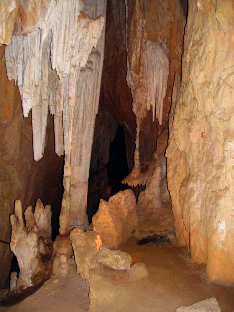
Cave interior with large cream and white stalactites hanging from the ceiling and stalagmites rising from the rocky floor, lit by warm artificial lighting against a dark background.
Interior of Fig Tree Cave at Wombeyan Caves showing dramatic stalactite and stalagmite formations illuminated by artificial lighting.

Wombeyan Caves history and protected-area timeline

The Wombeyan area has deep Indigenous associations, even though archaeologists have not yet confirmed direct Aboriginal occupation of the caves themselves. Stone flakes and cores from Aboriginal tool making, dating from roughly 6,000 to 14,000 years ago, have been found across the wider reserve. The site's name is widely thought to come from a Ngunnawal language word meaning tunnel, derived from a Dreamtime story of Gurangatch, a local rainbow serpent figure within Gandangara belief, who was said to have burrowed under the range and emerged inside the caves. The white settler spelling 'Wombeyan' evolved from earlier variants including Whambeyan, Wambian, Whombeyan, Wombeian, Wambiang and Wambeean.

European protection of the site began in 1865, with the area formally set aside as a reserve. Charles Chalker, appointed as the first government caretaker of the caves, played a formative role in establishing the identities of individual caverns by assigning them Gandangara names, several drawn from local rivers and one from Burra Burra clan leader Murrandah. Over time, the reserve's administrative framing evolved, and in December 1997 it was re-established in its present configuration as the Wombeyan Karst Conservation Reserve, managed by the NSW National Parks & Wildlife Service.

Wombeyan Caves landscape and geographic character

The Wombeyan landscape is built around a marble karst system set within the broader forested terrain of the Southern Highlands. The caves themselves have been slowly hollowed out of marble by groundwater, producing chambers with their own sculpted passages, flowstone formations and dramatic open spaces like the Victoria Arch. Above ground, the reserve lies in a region of rugged ridges and deeply cut valleys. The Wombeyan Caves Road climbs and descends through steep, narrow stretches as it crosses into the reserve, offering sweeping views across the surrounding ranges.

Outside the cave entrances the terrain includes creek lines, a waterfall and extensive tracts of forest that visitors can explore on foot. Smaller caves are scattered through this wooded landscape, often only reachable through longer walks, which gives the reserve a layered topography of underground chambers, forested slopes, watercourses and cliff-faces. The combination of karst geology with traditional Southern Highlands bush makes the visual character of the reserve quite distinct from the more open plains or coastal landscapes found elsewhere in New South Wales.

Wombeyan Caves ecosystems, habitats, and plant life

Ecologically, the Wombeyan Karst Conservation Reserve functions as a refuge for native fauna in a landscape increasingly shaped by human activity. The reserve sits within a forested catchment that supports a mix of typical Southern Highlands vegetation, with karst features contributing to ground-level habitat complexity, moisture variation and shelter opportunities for animals. The integration of intact bush with maintained camping grounds has allowed wildlife populations to remain present and visible in the heart of the reserve.

A wide range of native species is associated with the area, including several types of wallaby, possums, wombats and large numbers of kangaroos. Birdlife is particularly conspicuous, with magpies and Indian mynahs among the most frequently observed species around the campsite, alongside satin bowerbirds, currawongs and rosellas. The reserve's protected status, combined with its relatively secluded setting far from major urban centers, has allowed these communities to persist in numbers that make wildlife encounters an everyday feature of any visit.

Wombeyan Caves wildlife and species highlights

Wildlife is one of the defining elements of the Wombeyan experience, in part because of how visibly present animals are in and around the camping and visitor areas. Mob populations of kangaroos are a regular sight around the reserve, often grazing within metres of tents and picnic areas with no apparent wariness of people. This proximity has become both a signature attraction and a management concern, as rangers work to prevent unsafe human-wildlife associations and to safeguard the long-term welfare of animals that have grown unusually tolerant of human presence.

The reserve also supports a rich and varied bird community. Magpies and Indian mynahs are particularly bold around campers, sometimes approaching within less than a foot to demand food, while satin bowerbirds, currawongs and rosellas are also regularly recorded near the caves. Beyond these conspicuous species, the broader reserve provides refuge to several wallaby species, wombats and possums. The combination of forest cover, water sources and protected status makes the area an important local stronghold for native fauna that have declined across much of the more developed parts of New South Wales.

Wombeyan Caves conservation status and protection priorities

Conservation has been a formal purpose of the Wombeyan site since 1865, when the area was first reserved, and the modern Wombeyan Karst Conservation Reserve continues this legacy under the management of the NSW National Parks & Wildlife Service. The reserve protects both a nationally uncommon marble karst system and a functioning habitat for native wildlife in a part of New South Wales where pressures from rural land use and historical habitat loss have been significant. Its protected status gives native species including wallabies, wombats, possums, kangaroos and a wide variety of birds a refuge where populations can persist with minimal direct disturbance.

Management of the reserve balances tourism and ecological protection. Rangers stationed near the campsite collect fees, monitor interactions between visitors and wildlife, and work to prevent behaviors such as hand-feeding animals that could create long-term welfare risks for increasingly tame populations. While the closeness of wildlife to people is part of Wombeyan's appeal, it is also the source of ongoing conservation challenges, with concerns that the same habituation that delights visitors may ultimately compromise the health and natural behavior of local animals.

Wombeyan Caves cultural meaning and human context

Wombeyan Caves carries a strong Indigenous cultural identity that predates European contact by thousands of years. The reserve lies on the traditional lands of the Burra Burra clan of the Gandangara people, within the area covered by the Pejar Local Aboriginal Land Council. While no direct evidence of Indigenous occupation inside the caves themselves has yet been identified, stone flakes and cores associated with Aboriginal tool making and dating from roughly 6,000 to 14,000 years ago have been recorded elsewhere in the reserve.

The name 'Wombeyan' itself is widely understood to come from a Ngunnawal language word for tunnel, generating a place name that has survived through many European spellings, including Whambeyan, Wambian, Whombeyan, Wombeian, Wambiang and Wambeean. The word is tied to a Dreamtime narrative in which the rainbow serpent Gurangatch burrowed beneath the range and emerged inside the caves, a story recorded by Robert Hamilton Mathews. When the nineteenth-century caretaker Charles Chalker assigned Indigenous names to many of the individual caverns, several were drawn from Gandangara language and local Aboriginal figures, embedding Indigenous heritage into the very nomenclature of the cave system.

Top sights and standout views in Wombeyan Caves

Wombeyan Caves combines two standout features that are rarely found together: a marble karst cave system of real geological significance, and a wildlife experience where native animals approach visitors within touching distance. The Victoria Arch and Fig Tree Cave are the most accessible for casual visitors, while Junction, Wollondilly, Mulwaree and Kooringa caves, along with permit-led wild caving, give deeper access for more adventurous explorers. Above ground, the surrounding forest hides a creek, a waterfall and a scattering of smaller caves, making the reserve feel far larger than its modest footprint.

Equally distinctive is the cultural depth of the site, from the Ngunnawal origin of its name to the Gandangara designations of its individual caves. The result is a reserve that reads simultaneously as a geological showcase, a biodiversity refuge and a landscape carrying thousands of years of Indigenous heritage.

Best time to visit Wombeyan Caves

The Southern Highlands climate gives Wombeyan a generally mild year-round character, with cooler conditions in winter and warmer, drier weather in summer. Many visitors prefer the warmer months for camping and walking, when creek and waterfall sites are at their most inviting, but cooler months can offer more comfortable conditions for extended cave exploration. Wildlife viewing tends to be rewarding throughout the year, with kangaroos and bold magpies visible around the campsite regardless of season.

Monthly climate preview

Long term monthly temperature and precipitation rhythm for New South Wales

Wombeyan Caves Climate Normals and Annual Temperature Patterns

Historical measurements from a representative coordinate at Wombeyan Caves outline a structured annual cycle of fluctuating monthly temperatures and precipitation rates. Reviewing the complete twelve month dataset provides deeper analytical context for long term climatic conditions across the protected terrain.
Annual mean14 °C
6 °C21 °C
Jan21°
Feb20°
Mar17°
Apr14°
May10°
Jun
Jul
Aug
Sep10°
Oct14°
Nov17°
Dec19°
Warmest month
January

21.2 °C

Coolest month
July

6.3 °C

Wettest month
February

3.5 mm/day

Driest month
May

1.5 mm/day

Park location guide

Geography guide, regional context, and park location map for Wombeyan Caves

Wombeyan Caves park geography, regions, and map view in Australia

Understand where Wombeyan Caves sits in Australia through a broader geographic reading of the surrounding landscape, nearby location context, and its mapped position within the national park landscape.

How Wombeyan Caves fits into Australia

Australia is a constitutional monarchy and federal parliamentary democracy comprising six states and ten territories. With a population of nearly 28 million, it is one of the world's most urbanised countries, with most people concentrated on the eastern seaboard. The country has a high Human Development Index and is known for its cultural diversity, ancient Aboriginal heritage, and unique wildlife.

Wider geography shaping Wombeyan Caves in Australia

Australia occupies the entire Australian continent, the island of Tasmania, and numerous smaller islands. It is the world's flattest and driest inhabited continent, featuring vast deserts in the interior (the Outback), tropical rainforests along the eastern coast, and a coastline bordering the Indian and Pacific Oceans.

Map view of Wombeyan Caves

Use this park location map to pinpoint Wombeyan Caves in Australia, understand its exact geographic position, and read its mapped placement within the surrounding landscape more clearly.

Pigeon | © OpenStreetMap contributors

Location context for Wombeyan Caves

New South Wales

Visual reference guide for marble formations, subterranean chambers, and forested Southern Highlands terrain.

Wombeyan Caves Photos and Karst Landscape Scenery

Photographic collections reveal the marble karst architecture, massive subterranean arches, and rugged forest environments defining the Wombeyan reserve. Visual exploration clarifies the unique topography, native wildlife habitats, and complex geological formations shaping the protected landscape.

Cave interior with large cream and white stalactites hanging from the ceiling and stalagmites rising from the rocky floor, lit by warm artificial lighting against a dark background.

Park atlas

Compare regional protected areas, forest reserves, and neighboring karst terrain

Explore Other Parks Near Wombeyan Caves and Surrounding Protected Landscapes

Browse nearby national parks and protected areas to compare the rugged forest terrain and geological formations surrounding Wombeyan Caves. Expanding the geographic scope reveals connected regional landscapes and reveals broader conservation patterns across the Southern Highlands.
National parkNew South Wales
About 4.2 km away#1 closest

West

Mares Forest National Park: New South Wales National Park Atlas and Protected Landscape

Explore mapped boundaries and forest terrain.

Mares Forest National Park, situated in New South Wales, offers a distinct protected landscape defined by its wet eucalyptus forest and kurrajong trees. As a national park, it provides valuable insight into the regional geography of the Southern Tablelands, showcasing its unique terrain and role as wildlife habitat. This park serves as an essential point for atlas-based exploration of Australia's conservation estate, highlighting its mapped boundaries and natural features.

Area
25.59 km²
Established
2010
IUCN
II
Relief
Upland
National parkNew South Wales
About 13 km away#2 closest

East

Nattai National Park: Protected Landscape Within New South Wales Geography

Mapped boundaries and regional context for this national park.

Nattai National Park represents a distinct protected landscape within the broader geographic context of New South Wales, Australia. This entry focuses on its identity as a national park, detailing its mapped boundaries and its significance for structured geographic and atlas exploration. Users can uncover the specific park identity and its role within the regional mapped terrain.

Area
489.84 km²
Established
1991
IUCN
II
Visitors
1K annual
National parkNew South Wales
About 15 km away#3 closest

South

Tarlo River National Park: Rugged Protected Wilderness Landscape of New South Wales

Explore its unique terrain, mapped boundaries, and cultural heritage.

Tarlo River National Park stands as a testament to rugged protected wilderness within New South Wales, Australia. Its distinctive terrain, marked by steep valleys and rocky ridges, presents a rare topographical feature not replicated elsewhere in the region. This national park is also a vital site for Aboriginal cultural heritage, offering a unique lens through which to understand Australia's protected landscapes. The park's mapped geography provides essential context for appreciating its conservation significance and the preservation of its natural and cultural values.

Area
80.74 km²
Established
1982
IUCN
II
Relief
Upland
National parkNew South Wales
About 22 km away#4 closest

North

Kanangra-Boyd National Park: A Protected Landscape within New South Wales' Geography

Mapped boundaries and regional park context.

Kanangra-Boyd National Park represents a significant protected area, offering valuable insights into the natural landscapes and geographic context of New South Wales. As a national park, it provides a clear example of mapped terrain and protected land distribution, crucial for anyone exploring the atlas of Australian conservation areas. Understanding this park contributes to a broader appreciation of its regional geography and specific landscape identity.

Area
686.6 km²
Established
1969
IUCN
Ib
Relief
Mountain
National parkNew South Wales
About 23 km away#5 closest

Southeast

Bangadilly National Park: Protected Sandstone Plateau and Gorge Landscape in NSW

Explore its unique terrain and Wingecarribee River geography.

Bangadilly National Park, situated in New South Wales, is a critical protected area characterized by its striking sandstone plateau and gorge formations bordering the Wingecarribee River. As a strict nature reserve, it safeguards a significant transition zone for local flora and provides essential habitat for numerous rare and threatened species, making it a key site for understanding regional landscape ecology and protected area distribution in Australia.

Area
21.35 km²
Established
2001
IUCN
Ia
Relief
Mixed relief
National parkNew South Wales
About 23 km away#6 closest

Northwest

Abercrombie River National Park: A Protected Landscape in New South Wales

Explore its national park designation and mapped geography.

Delve into the details of Abercrombie River National Park, a designated national park situated in New South Wales. This entry focuses on its identity as a protected landscape, providing a geographically specific atlas perspective. Understand the extent of its mapped boundaries and its contribution to the regional geography, offering a clear view of its protected area status for discovery and reference.

Area
190 km²
Established
1995
IUCN
II
Relief
Mountain
A soft, horizontal watercolor painting depicting a calm wetland area with grassy banks, still water reflecting soft colors, and distant rolling hills.
Nature reserveNew South Wales
About 45 km away#7 closest

Southeast

Cecil Hoskins Nature Reserve Protected Wetland Landscape in New South Wales Australia

Mapped riverine terrain and ecological sanctuary boundaries

This protected area centers on the Wingecarribee River, providing a rare refuge for waterbirds and remnant native bushland in the Southern Highlands. The reserve integrates dammed swampy floodplains with open grassy meadows and eucalypt stands, creating a compact yet ecologically significant site that demonstrates the importance of small-scale landscape restoration in New South Wales.

Area
0.46 km²
Established
1975
IUCN
IV
Relief
Lowland
Watercolor landscape illustration showing green fields, trees, hills, and pastel sky
National parkNew South Wales
About 47 km away#8 closest

South

Morton National Park: A Protected Landscape of Waterfalls and Dissected Plateaus in New South Wales

Explore its mapped boundaries and regional geographic context.

Morton National Park is a nationally recognized protected area within New South Wales, Australia, celebrated for its striking natural features and geographic significance. The park's landscape is characterized by a dramatic dissected plateau, giving rise to impressive waterfall systems such as Fitzroy Falls and Belmore Falls that cascade into deep gorges. As a key component of the Southern Highlands' natural heritage, Morton National Park provides a rich subject for atlas exploration, offering insights into regional terrain, protected land distribution, and the unique interplay of natural elements within this Australian national park.

Area
1,997.45 km²
Established
1967
IUCN
II
Relief
Mixed relief

Common questions about visiting, size, designation, and location context for Wombeyan Caves

Wombeyan Caves FAQs for park facts, access, geography, and protected area context

Find quick answers about Wombeyan Caves, including protected-area facts, park geography, trail and visitor context, and how the park fits into its surrounding country and regional landscape.
MoriAtlas Explorer

Continue Your Protected Areas Search Across the Global Atlas

Deepen your exploration by continuing the structured search for national parks and protected areas worldwide. Utilize the comprehensive filtering capabilities to compare different conservation landscapes and refine your understanding of global park geography. Discover more about the distribution and characteristics of protected natural areas.

Global natural geography
