
Mori Atlas logo
Protected landscapeWössinger Waldwiesen

A structured analysis of meadow habitats, stream corridors, and forest edge ecosystems

Wössinger Waldwiesen Protected Landscape: Mapping the Kraichgau Valley Meadow Geography

Wössinger Waldwiesen represents a distinctive protected landscape within the Kraichgau region of Baden-Württemberg. This area preserves a rare combination of species-rich valley meadows, traditional orchard trees, and the vital headwaters of the Walzbach stream. The protected terrain serves as a model for integrated ecological management, where small-scale meadow habitats transition into structured broadleaf forest boundaries.

landscape protection areaorchard meadowvalley meadowKraichgauheadwater streamstream corridor
A flat-style digital illustration showing a valley scene with mountains in the background, a waterfall on the right, a winding river in the middle, and a green meadow with scattered trees in the foreground.

Wössinger Waldwiesen

Protected landscape

Park overview

Structured park overview, official facts, and landscape profile for Wössinger Waldwiesen

Wössinger Waldwiesen park facts, protected area profile, and essential visitor context

Review the core facts for Wössinger Waldwiesen, including designation, size, terrain, visitor scale, habitats, and operating context in one park-focused overview.

About Wössinger Waldwiesen

Wössinger Waldwiesen is a small landscape protection area that captures a quiet but ecologically meaningful stretch of the upper Kraichgau landscape. Located within the municipality of Bretten in the Karlsruhe district of Baden-Württemberg, the reserve lies in the upper Schifftal, a modest side valley that opens to the west and marks part of the headwater zone of the Walzbach, a stream of the Pfinz system. With a size of about 5.6 hectares, the protected area is small in absolute terms, but its composition reflects a classic transition zone between open rural land and forest, a pattern that has historically defined much of the Kraichgau.

The central feature of the area is an open, species-rich meadow that retains traditional orchard trees, giving it the structural diversity often associated with old cultural landscapes of the region. The valley meadow is bordered by forest on three sides, while the western end of the valley opens outward into the broader landscape. This arrangement creates a sheltered, bowl-like setting in which meadow, stream, and forest edge interact closely. The protection ordinance recognizes this interaction and seeks to preserve the full sequence: the valley and hillside meadows, the narrow stream with its woody margins, and the gradual conversion of a previous conifer plantation into a more ecologically appropriate broadleaf forest.

The reserve was formally designated on 14 December 1988, and its designation was carried out together with the protection of the Hungerquelle, a natural monument associated with the same stream. This joint designation reflects the recognition that the meadow's ecological value is closely linked to the hydrology and structure of the Walzbach headwaters. Today the area functions as a small but well-defined example of how traditional orchard meadows, stream corridors, and structured forest edges can be combined within a modest protected footprint in the Kraichgau landscape.

Quick facts and research context for Wössinger Waldwiesen

Wössinger Waldwiesen is a designated landscape protection area (Landschaftsschutzgebiet) with IUCN Category V status, equivalent to a Protected Landscape/Seascape. It is administered by the Karlsruhe district office (Landratsamt Karlsruhe) in the state of Baden-Württemberg, Germany. The area is part of the Kraichgau natural region and was designated by ordinance on 14 December 1988.

The protected area covers roughly 5.6 hectares in the upper Schifftal, near the headwaters of the Walzbach stream, and is bordered to the south by the Hungerquelle natural monument. It is classified under the official identifier 2.15.046 and is recorded in the World Database on Protected Areas under WDPA ID 325941. The site lies within the municipality of Bretten and was originally established alongside the adjacent Hungerquelle protection.

Protection and recognition

Documented terrestrial protection scope and international recognition data

Wössinger Waldwiesen Protection Status and Official Designated Records

Wössinger Waldwiesen maintains a documented terrestrial protection scope within the global protected area registry. Official records detail the administrative conservation framework and international recognition data associated with the site.

Protection details

Protection scope
Terrestrial
Transboundary protection
No
WDPA ID
325941
Park context

Deeper park guide and search-rich context for Wössinger Waldwiesen

Wössinger Waldwiesen history, landscape, wildlife, and travel context

Explore Wössinger Waldwiesen through its history, landscape character, ecosystems, wildlife, conservation priorities, cultural context, and seasonal travel timing in a structured park guide built for atlas discovery and search intent.

Why Wössinger Waldwiesen stands out

Wössinger Waldwiesen is best known for its compact but ecologically layered composition: a species-rich wet meadow with traditional orchard trees, enclosed on three sides by forest, and centered on the early course of the Walzbach stream. The reserve is valued as a representative example of a Kraichgau valley meadow landscape, where fruit-tree meadows, a narrow stream corridor, and structured forest edge come together in a small footprint. It is also recognized for its conservation approach, which combines the preservation of existing meadow and stream habitats with the gradual transformation of a former conifer stand into ecologically appropriate broadleaf forest. The pairing with the adjacent Hungerquelle natural monument gives the landscape additional hydrological and structural interest, reinforcing the area's identity as a coherent small-scale valley landscape.
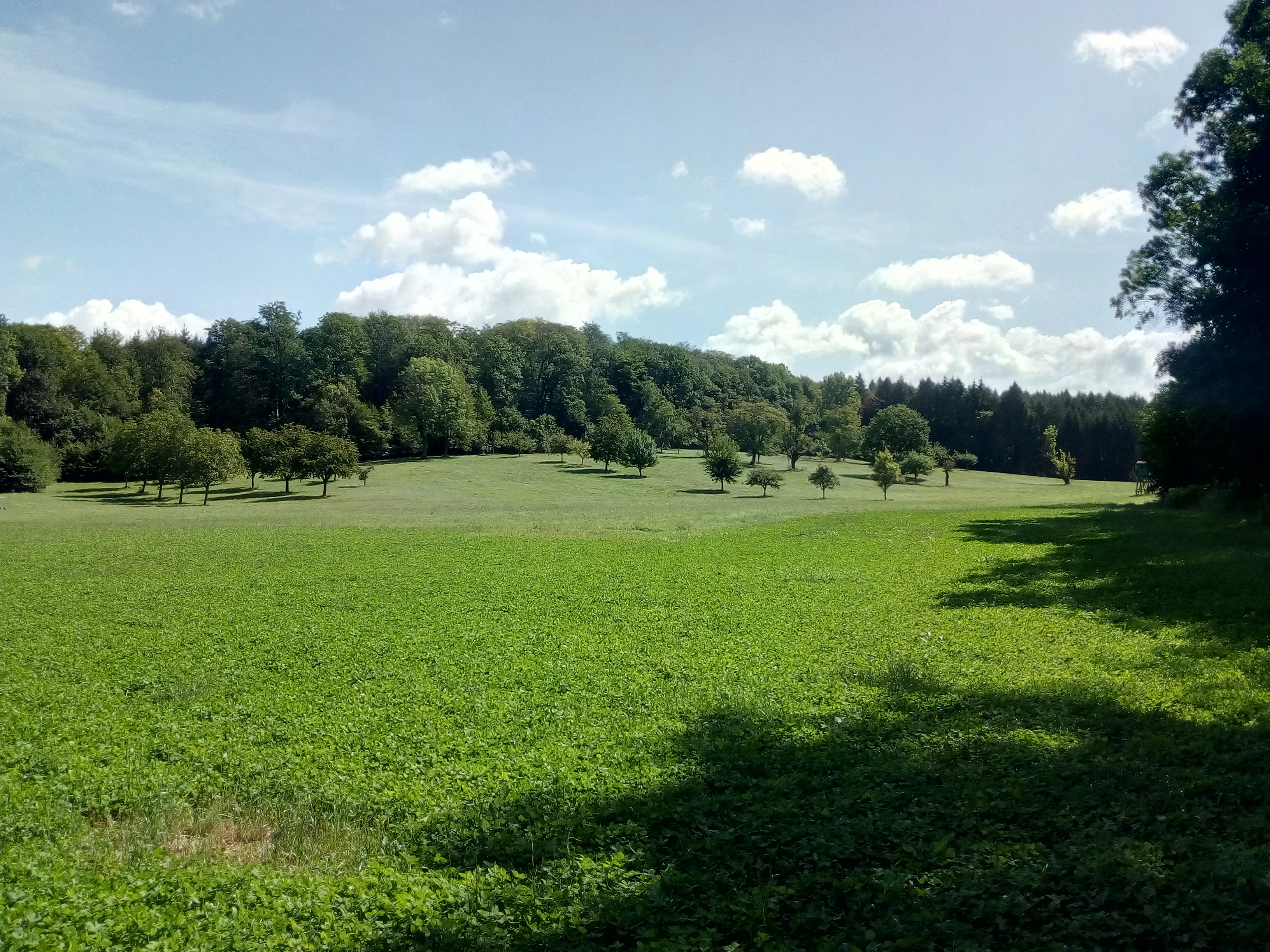
A wide, sunny view of a green meadow in the Wössinger Waldwiesen area, with scattered fruit trees and a dense forest line in the background under a blue sky with scattered clouds.
A view of the Wössinger Waldwiesen landscape protection area featuring open meadows and surrounding forests.

Wössinger Waldwiesen history and protected-area timeline

Wössinger Waldwiesen was established as a protected area on 14 December 1988 through a formal ordinance issued by the Karlsruhe district office. The designation defined the boundaries of the landscape protection area, identified the mechanisms of protection, and outlined the ecological goals intended for the site.

The protection ordinance focused on maintaining the traditional valley and hillside meadows, preserving the narrow stream and its woody margins, and initiating the conversion of an existing conifer plantation into a more ecologically suitable broadleaf forest, complemented by the creation of structurally complex forest edges. At the same time as the meadow reserve was established, the adjacent Hungerquelle spring feature on the Walzbach was designated as a natural monument, producing a continuous corridor of protection along the upper stream.

Since its designation, the area has remained a small, locally administered landscape protection area within the Karlsruhe district. It is registered as part of the state-level inventory of protected areas in Baden-Württemberg and recorded internationally under the World Database on Protected Areas. While the area is modest in scale, its establishment reflects the late-1980s pattern in Baden-Württemberg of formally recognizing small cultural landscapes that combine meadow, orchard, and forest elements in the Kraichgau.

Wössinger Waldwiesen landscape and geographic character

The landscape of Wössinger Waldwiesen is shaped by a narrow, westward-opening side valley in the Kraichgau natural region. The valley, known locally as the upper Schifftal, hosts the headwaters of the Walzbach, which gives the protected area a clear hydrological backbone. From the valley floor outward, the terrain gradually rises into forest-covered slopes.

The protected area is dominated by an open, species-rich valley meadow dotted with traditional fruit trees, the hallmark of older cultural landscapes in this part of Baden-Württemberg. The forest, which frames the meadow on three sides, displays the typical layered structure of small valley landscapes in the Kraichgau, including both older broadleaf stands and the remnants of a now-deprecated conifer plantation. A structured, multi-staged forest edge is an explicit aim of the protection ordinance and provides a gradual transition between the open meadow and the denser woodland.

To the south, the protected meadow area meets the Hungerquelle natural monument, an important spring feature along the same stream. Together the meadow, stream corridor, and spring create a continuous, well-defined element within the wider Kraichgau, characteristic of the region's gentle but structurally diverse terrain.

Wössinger Waldwiesen ecosystems, habitats, and plant life

The ecological identity of Wössinger Waldwiesen is built around a wet, species-rich valley meadow that has retained its traditional orchard character. Fruit trees scattered across the meadow provide structural variation and support a broad range of meadow, shrub-edge, and woodland-margin species within a small area. This combination of meadow and orchard trees is one of the most characteristic habitat patterns in the Kraichgau.

The Walzbach stream and its wooded margins add a distinct second habitat layer, creating a corridor of moisture-loving vegetation along the valley floor. Protection of the stream with its ligneous fringe is central to the site's ecological purpose and helps maintain the hydrological conditions on which the meadow depends. The forest that borders the meadow on three sides completes the ecological picture, offering both broadleaf woodland and the transitional zone where a former conifer plantation is gradually being replaced with more ecologically appropriate native tree cover.

The protection ordinance also aims to develop a structured forest edge, with multiple zones of vegetation, providing a buffered transition between open meadow and closed forest. This edge habitat is typically rich in insects, birds, and small mammals, and is a defining feature of well-managed orchard-meadow landscapes in the region. Together, meadow, stream, forest, and edge create a layered habitat mosaic that is compact but ecologically expressive.

Wössinger Waldwiesen wildlife and species highlights

Wössinger Waldwiesen supports wildlife associated with traditional orchard meadows, narrow wooded stream corridors, and forest edges in the Kraichgau. The combination of open, flower-rich meadow with scattered fruit trees provides nesting and foraging opportunities for typical meadow and hedgerow birds, while the adjacent forest edge offers additional structure for species that move between open and wooded habitats.

The moist conditions along the Walzbach stream corridor favor insects and other invertebrates that depend on damp, vegetation-rich environments, with knock-on effects for insectivorous birds and small mammals along the wooded margins. The structured forest edge target within the protection ordinance is expected to enhance this transition habitat further, supporting a more diverse range of woodland-edge species over time.

Because of the reserve's small size, the area is best understood as a local wildlife node rather than a large-scale habitat area. Its ecological value lies in the quality and connectivity of meadow, stream, and forest-edge habitats, rather than in any single dominant species.

Wössinger Waldwiesen conservation status and protection priorities

Wössinger Waldwiesen was designated as a landscape protection area to preserve a small but representative example of a Kraichgau valley landscape, combining meadow, orchard, stream, and forest in a single coherent unit. The protection ordinance explicitly identifies the conservation of valley and hillside meadows, the preservation of the Walzbach stream with its woody margins, and the gradual transformation of a former conifer stand into ecologically appropriate broadleaf forest as central goals. The development of a structured, layered forest edge is also a stated objective.

The protection of the adjacent Hungerquelle natural monument, designated at the same time, adds hydrological and structural value to the conservation effort. Together, the meadow area and the spring form a continuous protected corridor along the headwaters of the Walzbach, supporting both habitat and water quality. The reserve's IUCN Category V status reflects its character as a protected cultural landscape, in which traditional land use, ecological function, and landscape character are maintained together.

As a locally administered landscape protection area within the Karlsruhe district, the site contributes to the wider network of protected areas in Baden-Württemberg. Its modest footprint, combined with its layered habitat structure and clear conservation goals, gives it a value that extends well beyond its area on a map, particularly as a refuge for meadow, orchard, and stream-corridor species in a region where traditional land use has increasingly given way to more intensive forms of agriculture and forestry.

Wössinger Waldwiesen cultural meaning and human context

Wössinger Waldwiesen reflects the traditional cultural landscape of the Kraichgau, where orchard meadows, small valleys, and forest edges have long coexisted as part of everyday rural life. The presence of scattered fruit trees on a wet meadow, rather than in a closed orchard, is a hallmark of this older mixed-use pattern, often associated with small farming communities in the region.

The site's location within the municipality of Bretten, an old town in the Karlsruhe district, places it within a landscape shaped by centuries of agricultural and forestry activity. The protection of this small valley as a landscape protection area can be read as a regional acknowledgment that older patterns of land use, with their associated meadows, orchards, and forest edges, still carry ecological and cultural value worth preserving.

Top sights and standout views in Wössinger Waldwiesen

Wössinger Waldwiesen is a compact but well-structured protected landscape that captures several characteristic elements of the Kraichgau in a small footprint. The combination of a species-rich wet meadow, traditional orchard trees, the early course of the Walzbach, and bordering forest, including a former conifer stand being converted to broadleaf, gives the reserve a layered ecological personality that goes well beyond its 5.6 hectare size.

Its joint designation with the Hungerquelle natural monument adds hydrological significance, linking the meadow protection directly to the headwater spring of the Walzbach. The structured forest edge called for in the protection ordinance further strengthens the reserve's appeal as an example of integrated landscape-scale conservation in the region.

Best time to visit Wössinger Waldwiesen

As a small landscape protection area focused on meadow, orchard, and stream habitats, Wössinger Waldwiesen is most expressive from late spring into summer, when the species-rich wet meadow is in full bloom and the fruit trees are in leaf. Late spring and early summer typically offer the richest view of the meadow's floral composition, while the surrounding forest provides a quiet, shaded setting for walking through the valley.

Autumn also brings a distinctive character to the reserve, with fruit on the orchard trees and changing forest colors along the slopes around the meadow. The site's small size and low-elevation location in the Kraichgau mean that the area is generally accessible for short visits throughout the warmer half of the year, when the valley landscape is most visually rewarding.

Monthly climate preview

Long-term representative measurements and monthly weather patterns

Wössinger Waldwiesen Climate Normals, Annual Temperature and Precipitation

Representative coordinate records show average monthly temperatures ranging from sub-zero winter minimums to warm summer maximums alongside consistent daily precipitation rates. Examining the full twelve-month profile provides complete historical climate normals and detailed meteorological distributions for Wössinger Waldwiesen.
Annual mean9 °C
0 °C20 °C
Jan
Feb
Mar
Apr
May13°
Jun17°
Jul20°
Aug19°
Sep15°
Oct10°
Nov
Dec
Warmest month
July

19.6 °C

Coolest month
January

-0 °C

Wettest month
May

2.7 mm/day

Driest month
April

1.7 mm/day

Park location guide

Geography guide, regional context, and park location map for Wössinger Waldwiesen

Wössinger Waldwiesen park geography, regions, and map view in Germany

Understand where Wössinger Waldwiesen sits in Germany through a broader geographic reading of the surrounding landscape, nearby location context, and its mapped position within the national park landscape.

How Wössinger Waldwiesen fits into Germany

Germany is a federal republic in Western and Central Europe with a population of over 83 million across sixteen constituent states. It is Europe's largest economy by nominal GDP and a major global exporter and importer. The capital is Berlin, and the country borders Denmark, Poland, Czech Republic, Austria, Switzerland, France, Luxembourg, Belgium, and the Netherlands.

Wider geography shaping Wössinger Waldwiesen in Germany

Germany is located in Western and Central Europe, spanning 357,022 km². It borders Denmark to the north, Poland and the Czech Republic to the east, Austria and Switzerland to the south, and France, Luxembourg, Belgium, and the Netherlands to the west. The country has coastlines on the Baltic Sea and North Sea to the north, with the Alps located in the southern region.

Map view of Wössinger Waldwiesen

Use this park location map to pinpoint Wössinger Waldwiesen in Germany, understand its exact geographic position, and read its mapped placement within the surrounding landscape more clearly.

Pigeon | © OpenStreetMap contributors

Location context for Wössinger Waldwiesen

Baden-Württemberg

Visualizing valley meadows, stream corridors, and forest edge habitats

Wössinger Waldwiesen Photos and Landscape Scenery Exploration

Visual records capture the distinctive topography of Wössinger Waldwiesen, illustrating the delicate transition between open orchard meadows and dense woodland. Examining protected area photography reveals the complex ecological structure framing the headwaters of the Walzbach stream.

A wide, sunny view of a green meadow in the Wössinger Waldwiesen area, with scattered fruit trees and a dense forest line in the background under a blue sky with scattered clouds.

Park atlas

Compare regional valley meadows and connected protected areas across the Kraichgau terrain.

Exploring Parks Near Wössinger Waldwiesen and Surrounding Protected Landscapes

Compare Wössinger Waldwiesen with other protected areas and valley meadow reserves located across the surrounding Kraichgau region. Broaden your geographic perspective by examining adjacent stream corridors, woodland edges, and conserved cultural landscapes.
A watercolor illustration of a soft, rolling landscape featuring distant hills, forested midground, and a central winding meadow or stream area with wildflowers in the foreground.
Protected landscapeBaden-Württemberg
About 8 km away#1 closest

West

Pfinzgau Protected Landscape: Mapping the Cultural Terrain of the Kraichgau Region

A structured geographic overview of the Pfinz valley landscapes.

Pfinzgau preserves a mosaic of woodlands, meadows, and orchards in the Karlsruhe district of Baden-Württemberg. This protected landscape functions as a green corridor within the Kraichgau, featuring near-natural forests, ancient field hedges, and stream corridors that define the regional relief. Study the mapped boundaries and natural terrain of this significant conservation area as it navigates the transition between the Black Forest and the Odenwald.

Area
21.496 km²
Established
1991
IUCN
V
Relief
Upland
Watercolor painting showing a stylized, soft landscape with gentle green hills, a light-colored central valley area, and muted mountain silhouettes in the background.
Protected landscapeBaden-Württemberg
About 8.1 km away#2 closest

Southeast

Gengenbachtal und Dolinenlandschaft südlich Göbrichen: Protected Landscape and Karst Geography

Geographic profile of the Enzkreis district in Baden-Württemberg

This protected area captures the contrast between the wooded Gengenbach stream valley and the doline-studded meadows of the Kraichgau. By preserving these distinct meadow and karst habitats, the landscape provides a clear window into the geological transition between the Black Forest and the surrounding plateaus of southwestern Germany.

Area
3.398 km²
Established
1952
IUCN
V
Protected landscapeBaden-Württemberg
About 12 km away#3 closest

Northwest

Weingartener Wiesental Protected Landscape: Geography and Meadow Valley Overview

Historic irrigation heritage in the Baden-Württemberg region.

The Weingartener Wiesental provides a clear example of a managed meadow valley landscape, featuring an extensive network of historical irrigation ditches and a surviving aqueduct. Situated within the Hardtebenen natural region, this protected area serves as an ecological buffer and a window into the traditional land management practices characteristic of the Kinzig-Murg-Rinne river corridor.

Area
1.109 km²
Established
1991
IUCN
V
Relief
Lowland
A watercolor landscape illustration showing a gently winding water feature through low-lying marshy vegetation with distant rolling hills.
Protected landscapeBaden-Württemberg
About 13 km away#4 closest

West

Füllbruch-Vokkenau Protected Landscape: Geographic Profile and Regional Map Context

Wetland mosaic and flood-retention geography in Baden-Württemberg

This protected landscape in Karlsruhe encompasses a distinct lowland floodplain forest, merging traditional orchard meadows with structured wet woodland terrain. The area is defined by its role in regional flood management for the Pfinz river, creating a unique intersection of protected natural habitat and active hydraulic infrastructure within the historical Kinzig-Murg lowland channel.

Area
4.313 km²
Established
1988
IUCN
V
Protected landscapeBaden-Württemberg
About 15 km away#5 closest

South

Grafenhausener Kirschengau: Protected Landscape and Regional Geography in Baden-Wurttemberg

Orchard meadows and Arnbach stream valley terrain.

Spanning 137 hectares near Birkenfeld, the Grafenhausener Kirschengau preserves a vital cultural and ecological mosaic in the Kraichgau uplands. This protected landscape combines calcareous grasslands, wooded slopes, and riparian gallery forest, offering a detailed glimpse into the region's traditional land-use history and geological heritage.

Area
1.366 km²
Established
1983
IUCN
V
Relief
Upland
Nature reserveBaden-Württemberg
About 20 km away#6 closest

South

Eyach oberhalb Neuenbürg Nature Reserve: Mapped Geography and Protected Area Context

A diverse habitat mosaic in the northern Black Forest highlands

The Eyach oberhalb Neuenbürg nature reserve protects an intricate valley system that cuts through the northern Black Forest. This site is defined by its rich variety of forest, grassland, and rocky habitats clustered across steep hillsides and plateau surfaces. The data highlights the essential land cover and topographical features that sustain this protected area within the Baden-Württemberg regional landscape, offering a precise look at its ecological configuration and physical boundaries.

Area
3.219 km²
Established
2019
Relief
Mountain
Climate
Temperate
Protected landscapeBaden-Württemberg
About 22 km away#7 closest

North

Um die Großwiese Protected Landscape: Geography of the Northern Kraichgau Cultural Mosaic

Mapped protected area in the Landkreis Karlsruhe region.

Um die Großwiese is a designated landscape protection area in Bad Schönborn, characterizing the transitional foothill zone of the Kraichgau. The terrain comprises a high-value collection of sessile oak and hornbeam forests, traditional orchards, and riparian stream corridors. This detailed atlas entry provides context on the physical boundaries and landscape elements preserved within this German regional site.

Area
2.529 km²
Established
1990
IUCN
V
Relief
Upland
A soft watercolor illustration of a rolling meadow landscape featuring green grasses and pink flowers against a light background.
Protected landscapeBaden-Württemberg
About 22 km away#8 closest

North

Hambrücker Wiesen Protected Landscape: A Geographical Atlas of Baden-Württemberg Terrain

Mapped meadows, wetland corridors, and regional landscape boundaries

Spanning 107 hectares in the Hardtebenen, Hambrücker Wiesen functions as a critical protected landscape in Baden-Württemberg. The area anchors a diverse geographic profile featuring lowland hay meadows, reed beds along the Wagbach, and open agricultural terrain. Discover how this site integrates into the broader network of protected zones within the Upper Rhine Plain while preserving its traditional rural character against development.

Area
1.066 km²
Established
1991
IUCN
V
Relief
Lowland

Common questions about visiting, size, designation, and location context for Wössinger Waldwiesen

Wössinger Waldwiesen FAQs for park facts, access, geography, and protected area context

Find quick answers about Wössinger Waldwiesen, including protected-area facts, park geography, trail and visitor context, and how the park fits into its surrounding country and regional landscape.
MoriAtlas Explorer

Continue Your Protected Areas Search Across the Global Atlas

Deepen your exploration by continuing the structured search for national parks and protected areas worldwide. Utilize the comprehensive filtering capabilities to compare different conservation landscapes and refine your understanding of global park geography. Discover more about the distribution and characteristics of protected natural areas.

Global natural geography