
Mori Atlas logo
Nature reserveWunderwäldchen

Analyzing the botanical diversity and carbonate soil landscapes of a fragmented Lenne valley reserve

Wunderwäldchen Nature Reserve: A Protected Beech and Oak Woodland in the Kreis Olpe Region

(Naturschutzgebiet Wunderwäldchen)

Wunderwäldchen represents a compact and ecologically significant nature reserve located on the municipal boundary between Attendorn and Lennestadt in Kreis Olpe. This protected field woodland, characterized by its mature beech and oak canopy, thrives on unique carbonate-weathered soils that support a distinct concentration of rare woodland flora. As a preserved habitat fragment within the broader Sauerland landscape, the reserve offers a focused look at small-scale forest conservation in an otherwise agricultural and developed setting.

field woodlandFeldgehölzbeech-oak forestbroadleaf woodlandSauerlandLenne valley
A flat-style digital illustration showing a lush forest valley with trees in the foreground, steep cliffs in the background, a cascading waterfall, and a warm sun in the sky.

Wunderwäldchen

Nature reserve

Park overview

Structured park overview, official facts, and landscape profile for Wunderwäldchen

Wunderwäldchen park facts, protected area profile, and essential visitor context

Review the core facts for Wunderwäldchen, including designation, size, terrain, visitor scale, habitats, and operating context in one park-focused overview.

About Wunderwäldchen

Wunderwäldchen is one of many small, dedicated nature reserves that dot the rural landscape of the Sauerland region in western North Rhine-Westphalia. Despite covering only a fraction of a hectare, it plays a meaningful role in local biodiversity conservation because it shelters a beech-oak woodland community on carbonate-weathered soil, a substrate that supports a richer woodland flora than is typical for the surrounding area.

The woodland sits south of the river Lenne, on the boundary between the town of Attendorn to the north and Lennestadt to the south, near the small settlements of Röllecken and Grevenbrück. This position, sandwiched between two municipalities and two administrative jurisdictions, has shaped how the site is managed: rather than being treated as one reserve, it is designated as two adjacent Naturschutzgebiete, NSG OE-041 in Attendorn and NSG OE-014 in Lennestadt, separated only by the municipal line.

Although the protected area is small in absolute terms, its ecological value lies in its plant diversity. The reserve preserves habitat for species such as common wild ginger (Asarum europaeum), which is otherwise uncommon in the wider agricultural and settlement landscape around the Lenne valley. The site's long protection history, dating back to 1981, and its inclusion in the Attendorn-Heggen-Helden landscape plan reflect the recognition, even of modest woodland patches, as important refuges for native woodland flora in an otherwise heavily used region.

Quick facts and research context for Wunderwäldchen

Wunderwäldchen is a North Rhine-Westphalia Naturschutzgebiet classified under IUCN Category IV (Habitat/Species Management Area), managed by the Untere Landschaftsbehörde of Kreis Olpe. It lies on the Attendorn-Lennestadt municipal boundary south of the Lenne river, at roughly 301 to 317 metres above sea level. The total protected area is only about 0.73 hectares, divided into a northern Attendorn parcel NSG OE-041 (around 0.4 ha) and a southern Lennestadt parcel NSG OE-014 (around 0.3 ha). Designated in 1981, the reserve safeguards a beech-oak field woodland on carbonate-weathered soil that is notable for its species-rich woodland flora.

Protection and recognition

Documented protection records and management scope for Wunderwäldchen

Wunderwäldchen Protection Status and Terrestrial Conservation Data

Wunderwäldchen maintains a terrestrial protection scope governed by official conservation frameworks and administrative records. Consult structured protection data to examine formal designation metrics and international recognition sources for this landscape.

Protection details

Protection scope
Terrestrial
Transboundary protection
No
WDPA ID
378330
Park context

Deeper park guide and search-rich context for Wunderwäldchen

Wunderwäldchen history, landscape, wildlife, and travel context

Explore Wunderwäldchen through its history, landscape character, ecosystems, wildlife, conservation priorities, cultural context, and seasonal travel timing in a structured park guide built for atlas discovery and search intent.

Why Wunderwäldchen stands out

Wunderwäldchen is best known as a small but botanically rich beech-oak field woodland on carbonate-derived soils in the Olpe district. Its reputation rests on the unusual concentration of woodland plant species in such a tiny area, and specifically on its isolated populations of common wild ginger (Asarum europaeum), a species that is otherwise uncommon in the local landscape. Because it lies along the Lenne valley on the Attendorn-Lennestadt boundary, the reserve is also a useful example of how wooded habitat fragments can be preserved at the interface between two municipalities.
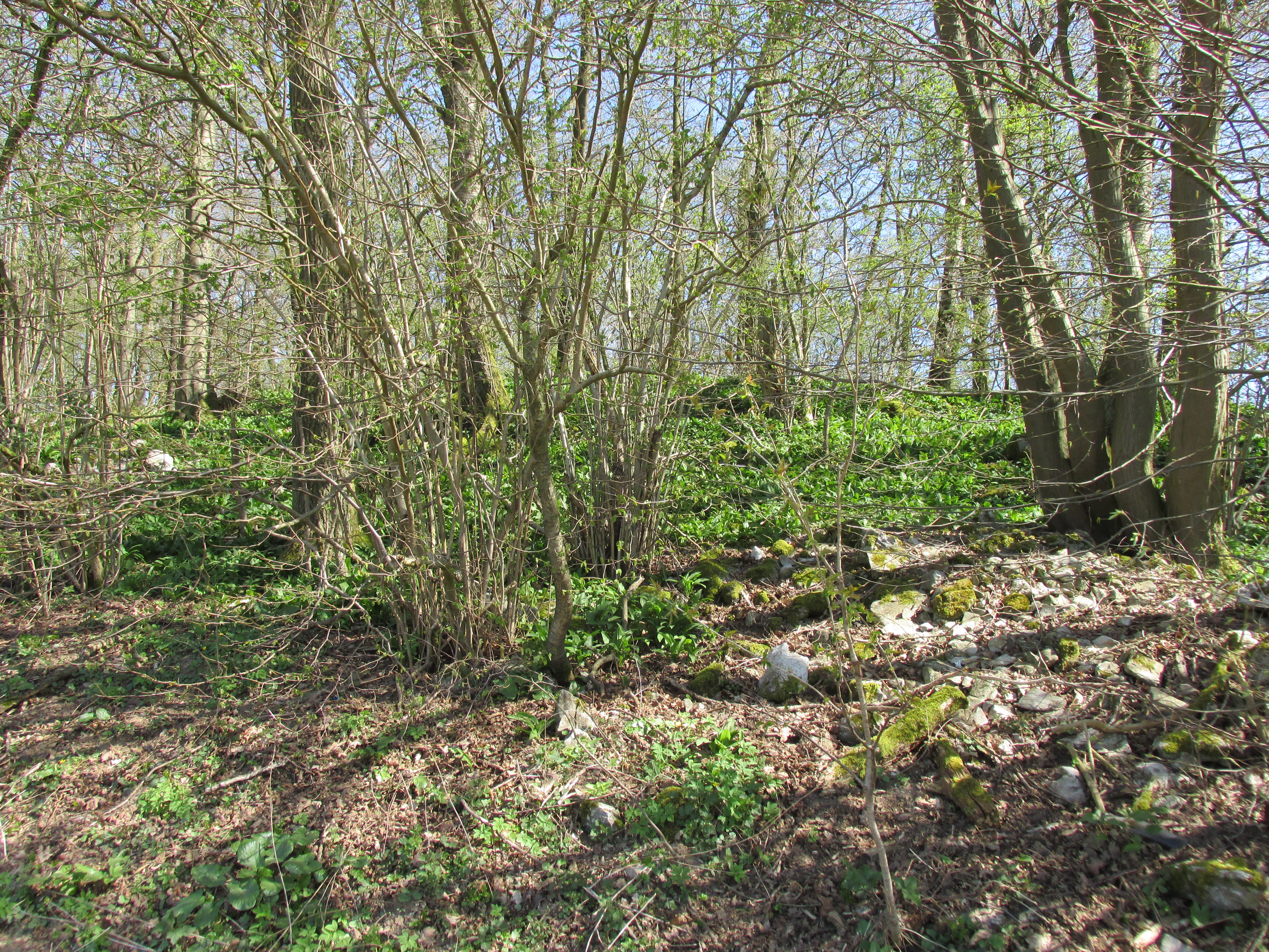
A sloped forest floor covered in low green vegetation, under a canopy of deciduous trees with early spring leaves.
A view of the woodland landscape within the Wunderwäldchen nature reserve.

Wunderwäldchen history and protected-area timeline

Wunderwäldchen has been formally protected as a Naturschutzgebiet since 1981. Its designation reflected concern for the long-term survival of its species-rich beech-oak woodland flora on carbonate-weathered soils, particularly the presence of uncommon woodland herbs such as common wild ginger (Asarum europaeum).

Because the woodland straddles the boundary between Attendorn and Lennestadt, protection has been administered through two parallel designations rather than a single unified reserve. The northern portion in Attendorn was designated under the Attendorn-Heggen-Helden landscape plan, where it is listed as Wunderwäldchen (LP) under the code NSG OE-041. The southern portion in Lennestadt was subsequently designated in 2005 under a dedicated ordinance as Wunderwäldchen (VO), under the code NSG OE-014. Today, both parcels are managed by the Untere Landschaftsbehörde of Kreis Olpe as a continuous ecological unit despite their separate administrative identities.

Wunderwäldchen landscape and geographic character

The landscape of Wunderwäldchen is defined by a steep, narrow Lenne valley setting in which small fragments of woodland still cling to slopes and field edges amid farmland and settlement. The reserve itself occupies a modest wooded rise on the boundary between Attendorn and Lennestadt, where carbonate-weathered soils have produced a substrate richer in woodland species than the typical upland soils of the wider Sauerland.

The terrain sits between roughly 301 and 317 metres above sea level, a relatively low elevation for the region, reflecting its position along the Lenne rather than up on the surrounding plateau. Nearby villages include Röllecken, the closest settlement on the Attendorn side to the west, and Grevenbrück on the Lennestadt side to the east. The wooded patch is bordered by agricultural land, roads, and the built-up edges of these communities, making it a small but visually striking island of mature broadleaf forest in an otherwise open landscape.

Wunderwäldchen ecosystems, habitats, and plant life

Ecologically, Wunderwäldchen is significant because it preserves a mature beech-oak field woodland, a habitat type that has become increasingly rare and fragmented in the intensively used agricultural and settlement landscape of the Olpe district. The woodland grows on carbonate-weathering soils, which locally produce a richer base status and, in turn, support a notably diverse woodland understorey.

The most distinctive aspect of the site's flora is the presence of uncommon woodland herbs that depend on these base-rich conditions and on the relatively undisturbed forest floor of an older broadleaf wood. Common wild ginger (Asarum europaeum) is the standout species, noted as particularly worthy of protection within the reserve. Beyond individual species, the site's broader ecological value lies in its function as refugium habitat, a small but stable woodland patch where shade-loving forest plants can persist long term amid an otherwise open landscape.

Wunderwäldchen wildlife and species highlights

Wunderwäldchen's wildlife profile is shaped primarily by its character as a small broadleaf woodland fragment in a landscape dominated by farmland and villages. Such patches typically support typical woodland fauna of the Sauerland, including common forest birds, small mammals, and a rich invertebrate community associated with mature deciduous trees and a herb-rich forest floor. The site's botanical richness, especially its base-rich woodland flora, in turn supports pollinator and detritivore communities on the forest floor.

No rare or highly specialised vertebrate fauna is highlighted in the source material, and the reserve's main wildlife significance lies more in the ecological context it provides, as a long-standing woodland refuge for shade-dependent species, than in headline charismatic fauna.

Wunderwäldchen conservation status and protection priorities

From a conservation perspective, Wunderwäldchen is valued less for its size than for what it preserves. Although it covers only about 0.73 hectares in total, it guards a beech-oak woodland community and base-rich woodland flora that have largely disappeared from the surrounding intensively used landscape. Its protection status as a Naturschutzgebiet since 1981, and its 2005 reaffirmation through a dedicated ordinance in Lennestadt, shows that local authorities treat the woodland as a long-term refuge rather than a temporary conservation measure.

Its IUCN Category IV classification as a Habitat/Species Management Area reflects its role in managing and maintaining a specific habitat type, in this case a field woodland, together with the species that depend on it, notably uncommon woodland plants such as common wild ginger. The site's split administration across Attendorn and Lennestadt makes it a small but instructive example of cross-boundary conservation cooperation within Kreis Olpe.

Wunderwäldchen cultural meaning and human context

The cultural context of Wunderwäldchen is closely tied to the rural character of the Lenne valley and the broader Sauerland region. The reserve lies between the small communities of Röllecken on the Attendorn side and Grevenbrück on the Lennestadt side, both of which have long histories tied to farming, small-scale forestry, and the milling and metalworking industries that once lined the Lenne river. The woodland itself is a remnant of the broader wooded landscape that once covered much of the valley, now reduced to small hedgerow, field-edge, and slope fragments amid modern land use.

In this sense, the reserve represents not only an ecological refuge but also a surviving piece of the traditional wooded rural landscape of the Olpe district, where field woodlands, or Feldgehölze, were once a characteristic feature of cultivated land.

Top sights and standout views in Wunderwäldchen

Among the standout features of Wunderwäldchen are its unusual combination of very small size and high botanical diversity, anchored by the presence of common wild ginger on base-rich woodland soils. The reserve is also notable for being formally split between two municipalities, with separate but adjacent Naturschutzgebiete in Attendorn and Lennestadt, making it a striking example of small-scale, cross-boundary habitat protection. Its position south of the Lenne valley, in a setting of farmland and small villages, gives it a strong role as a long-term woodland refuge in an otherwise open countryside.

Best time to visit Wunderwäldchen

Wunderwäldchen can be appreciated at any time of year, but its character shifts clearly with the seasons. In spring, the woodland understorey comes alive, making it the most rewarding time to observe the wildflower and herb layer, including the rare wild ginger populations that are central to the site's conservation value. Summer offers a dense, shaded canopy that emphasizes the woodland's contrast with the surrounding open farmland. In autumn, the beech and oak trees produce a colourful leaf display, while winter reveals the structural form of the trees and the small, compact nature of the protected woodland against the broader rural landscape.

Monthly climate preview

Long-term representative temperature and precipitation averages for Wunderwäldchen

Wunderwäldchen Climate Normals and Measured Monthly Weather Patterns

Historical measurements from 1991 to 2020 document the measured monthly temperature range and precipitation rates across a representative coordinate in Wunderwäldchen. Examining the full twelve-month profile provides complete historical averages for detailed climate comparison.
Annual mean8 °C
-1 °C17 °C
Jan-1°
Feb
Mar
Apr
May12°
Jun15°
Jul17°
Aug17°
Sep13°
Oct
Nov
Dec
Warmest month
July

17.4 °C

Coolest month
January

-0.7 °C

Wettest month
December

3 mm/day

Driest month
April

1.8 mm/day

Park location guide

Geography guide, regional context, and park location map for Wunderwäldchen

Wunderwäldchen park geography, regions, and map view in Germany

Understand where Wunderwäldchen sits in Germany through a broader geographic reading of the surrounding landscape, nearby location context, and its mapped position within the national park landscape.

How Wunderwäldchen fits into Germany

Germany is a federal republic in Western and Central Europe with a population of over 83 million across sixteen constituent states. It is Europe's largest economy by nominal GDP and a major global exporter and importer. The capital is Berlin, and the country borders Denmark, Poland, Czech Republic, Austria, Switzerland, France, Luxembourg, Belgium, and the Netherlands.

Wider geography shaping Wunderwäldchen in Germany

Germany is located in Western and Central Europe, spanning 357,022 km². It borders Denmark to the north, Poland and the Czech Republic to the east, Austria and Switzerland to the south, and France, Luxembourg, Belgium, and the Netherlands to the west. The country has coastlines on the Baltic Sea and North Sea to the north, with the Alps located in the southern region.

Map view of Wunderwäldchen

Use this park location map to pinpoint Wunderwäldchen in Germany, understand its exact geographic position, and read its mapped placement within the surrounding landscape more clearly.

Pigeon | © OpenStreetMap contributors

Location context for Wunderwäldchen

Kreis OlpeNordrhein-Westfalen

Visualizing the beech and oak woodland habitats across the Lenne valley terrain.

Wunderwäldchen Photos and Landscape Scenery: Protected Area Visual Guide

Visual documentation captures the compact field woodland and carbonate soils that define the protected landscape. Examining these field photographs reveals the rare botanical composition and mature broadleaf canopy thriving within an agricultural valley setting.

A sloped forest floor covered in low green vegetation, under a canopy of deciduous trees with early spring leaves.

A dirt path follows the edge of a dense, leafy deciduous forest under a clear blue sky in spring.

Park atlas

Compare adjacent woodland reserves and regional protected landscapes across the Lenne valley

Explore Other Parks Near Wunderwäldchen and Surrounding Protected Areas

Visitors exploring Wunderwäldchen can browse nearby protected areas and connected woodland fragments across the surrounding region. Comparing adjacent nature reserves reveals broader patterns in regional biodiversity and valley topography.
A horizontal watercolor painting depicting a gentle, light-filled landscape featuring soft green trees, rolling hills, and a small water feature.
Nature reserveNorth Rhine-Westphalia
About 2.5 km away#1 closest

Northwest

Hohe Ley Nature Reserve: Limestone Cliffs and Forest Geography in North Rhine-Westphalia

Protected calcareous woodland and raptor breeding habitat

This nature reserve in the Sauerland region features a prominent limestone cliff and a complex mosaic of woodruff and wavy hair grass beech forests. As part of a larger European habitat network, the reserve supports rare dry grassland and ravine woodland communities. Its topography provides critical nesting sites for eagle owls and common kestrels, anchoring a valuable ecological corridor within the local landscape.

Area
0.498 km²
Established
1981
A soft watercolor illustration of a landscape featuring green rolling hills, a meandering river or stream, and distant low mountains under a light sky.
Nature reserveNorth Rhine-Westphalia
About 3.6 km away#2 closest

West

Naturschutzgebiet Ahauser Klippen und Stausee: Protected Area and Limestone Landscape Atlas

A key nature reserve in the Attendorn-Elsper limestone basin of North Rhine-Westphalia.

Naturschutzgebiet Ahauser Klippen und Stausee is a compact yet ecologically rich nature reserve defined by carbonate geology and steep cliff biotopes. The area serves as a core refugial site within the Sauerland, integrating diverse forest stands, rare fissure vegetation, and essential waterbird resting zones at the reservoir edge.

Area
0.239 km²
Established
2003
IUCN
IV
Relief
Upland
Nature reserveNorth Rhine-Westphalia
About 9.1 km away#3 closest

West

Heinrich-Bernhard-Höhle Nature Reserve and Karst Landscape in North Rhine-Westphalia

Examining the geology and protection status of the Sauerland karst system

The Heinrich-Bernhard-Höhle represents a unique convergence of conservation designations, functioning as a nature reserve, paleontological monument, and FFH habitat area. Centered on a 192-meter limestone cave network, the site preserves essential subterranean geological structures and surface beech forests within the North Rhine-Westphalia region.

Area
0 km²
Established
1934
Relief
Upland
Access
Highly restricted
Nature reserveKreis Olpe
About 11 km away#4 closest

Southwest

Naturschutzgebiet Ahetal und Langes Siepen: Geography and Protected Area Overview

Nature reserve in the Rothaar foothills, Kreis Olpe

Covering the Ahe valley and its headwater catchment, this nature reserve is defined by its exceptionally dense concentration of seepage springs and near-natural brooks. The landscape transitions from shaded alder-lined seepage valleys into open, species-rich grassland, providing a critical refuge for local woodland species. As part of the Rothaarvorhöhen biotope network, it represents a significant, compact example of central upland stream valley geography.

Area
0.407 km²
Established
2020
Water
Major water bodies
A watercolor painting showing a tranquil reservoir surrounded by rolling green hills, forests, and grassy shorelines under a pale sky.
Protected areaNordrhein-Westfalen
About 13 km away#5 closest

Southwest

Listertalsperre Reservoir and Protected Forest Landscape in North Rhine-Westphalia

Historic gravity dam and regional hydrologic landmark.

Explore the detailed geography of Listertalsperre, a unique reservoir site characterized by its historic stone masonry dam and role in the regional water supply. This protected area offers insight into the engineered landscapes of the Sauerland, featuring forest-covered ridges and specialized waterfowl habitats that define this segment of the regional watershed.

Area
1.68 km²
Established
1912
Relief
Upland
Climate
Temperate
Watercolor painting of a green, rolling landscape with trees and distant hills against a white background.
Nature reserveNordrhein-Westfalen
About 15 km away#6 closest

East

Naturschutzgebiet Schluchtwald bei Hundesossen: Forest Reserve and Protected Landscape Atlas

Ravine forest and spring habitats in the Sauerland region

Located in the Lenne valley, this nature reserve is a benchmark for central European Schluchtwald ravine forests. The site supports dense beech stands and specialized spring-fed microhabitats on steeply dissected slopes. It serves as a key component of the regional conservation network, offering deep insights into the ecological structure of protected deciduous woodlands in the Rothaargebirge uplands.

Area
0.297 km²
Established
2008
IUCN
IV
Relief
Upland
Nature reserveKreis Olpe
About 15 km away#7 closest

Southwest

Naturschutzgebiet Olpetal und Altenkleusheimer Bachtal: Protected Valley and Brook Geography

Riparian ecosystems in the Kreis Olpe district

Located in the Rothaar foothills, this nature reserve spans nearly 37 hectares of stream valleys and floodplain meadows. The protected landscape includes alder-lined watercourses, spring-fed wetlands, and diverse slope vegetation, serving as a core component of the regional biotope network in North Rhine-Westphalia.

Area
0.372 km²
Established
2020
Relief
Upland
Climate
Temperate
Watercolor painting of a soft, rolling landscape with light green fields, scattered trees, and muted pink-toned hills.
Nature reserveNorth Rhine-Westphalia
About 16 km away#8 closest

West

Naturschutzgebiet Oberes Elsetal: Protected Brook Valley Geography in North Rhine-Westphalia

Mapping riparian ecosystems and low mountain range stream habitats.

Naturschutzgebiet Oberes Elsetal offers a detailed look at the structural interplay between spring-fed brooks and adjacent marshy grasslands. This nature reserve in the Südsauerländer Bergland provides an instructive map of how riparian alder gallery woodland, oak-hornbeam forest, and wet meadow communities converge in a compact, highly specialized valley setting.

Area
0.053 km²
Established
1998
Relief
Upland
Scope
Terrestrial

Common questions about visiting, size, designation, and location context for Wunderwäldchen

Wunderwäldchen FAQs for park facts, access, geography, and protected area context

Find quick answers about Wunderwäldchen, including protected-area facts, park geography, trail and visitor context, and how the park fits into its surrounding country and regional landscape.
MoriAtlas Explorer

Continue Your Protected Areas Search Across the Global Atlas

Deepen your exploration by continuing the structured search for national parks and protected areas worldwide. Utilize the comprehensive filtering capabilities to compare different conservation landscapes and refine your understanding of global park geography. Discover more about the distribution and characteristics of protected natural areas.

Global natural geography