
Mori Atlas logo
Nature reserveZeppelinhalde

A rare juniper-dominated dry grassland slope positioned within the cross-border Palatinate Forest mosaic.

Zeppelinhalde Nature Reserve: Exploring the Protected Juniper Hillside Landscape of Rheinland-Pfalz

(Naturschutzgebiet Zeppelinhalde)

Zeppelinhalde is a significant nature reserve located on the eastern slopes of the Kuhnenkopf within the Rheinland-Pfalz region. This protected area represents a rare, surviving example of a Wacholderhalde, or juniper hillside, which occupies a transitional zone between the open agricultural meadows near Nothweiler and the dense wooded ridges of the Palatinate Forest. Its 14 hectares form a crucial node in a broader network of connected habitats, including the nearby Brauntal and Königsbruch reserves near the international border.

Wacholderhaldejuniper hillsidedry grasslandshrublandPalatinate ForestRhineland-Palatinate
A flat-style digital illustration showing a forest valley with a waterfall cascading from a high rock cliff, mountains in the distance, and pine trees in the foreground.

Zeppelinhalde

Nature reserve

Park overview

Structured park overview, official facts, and landscape profile for Zeppelinhalde

Zeppelinhalde park facts, protected area profile, and essential visitor context

Review the core facts for Zeppelinhalde, including designation, size, terrain, visitor scale, habitats, and operating context in one park-focused overview.

About Zeppelinhalde

Zeppelinhalde is a compact nature reserve in the southwestern corner of Rhineland-Palatinate, in the Landkreis Südwestpfalz. Although the area is small, roughly 14 hectares, it plays an important local role in preserving a juniper hillside habitat that was once more widespread across the southern Palatinate slopes. The reserve's designation in 1942 places it among the older small-scale protected habitats in the region, predating many modern conservation designations and reflecting mid-twentieth century German interest in preserving distinctive local landscapes.

The reserve sits west of the village of Nothweiler, on the eastern side of the Kuhnenkopf. Topographically, the area can be described as a sloping transition between agricultural meadows near the village and the wooded ridges of the Palatinate Forest. To the west, the terrain rises into a mountain saddle at around 441 meters, which separates the Kuhnenkopf at 531 meters to the south, where the nearby Wegelnburg and Schlossberg also rise to roughly 570 meters, from the northern lower ground at about 350 meters. The result is an exposed, sun-facing slope that supports warm-loving vegetation communities rather than dense forest.

A defining feature of Zeppelinhalde is its juniper-dominated character. The German term Wacholderhalde refers to a hillside covered or historically covered by common juniper (Juniperus communis), often mixed with other low shrubs, dry grassland species, and open ground. Such habitats depend on a particular combination of slope, soil, and historical land use, and they have become uncommon in the region as juniper shrubs have been increasingly shaded out by advancing woodland. By protecting the juniper structure and the associated dry slopes, Zeppelinhalde helps preserve a habitat type that is linked to the cultural and ecological history of the lower Palatinate Forest.

The reserve does not stand alone. To the northwest, it connects with the neighbouring Brauntal and Königsbruch nature reserves, creating a near-continuous corridor of protected hillside and valley habitats along the German side of the border. Unweit to the southeast runs the international border with France, putting Zeppelinhalde within a cross-border ecological landscape shaped by the Wasgau, the German name for the joint southern Palatinate and northern Vosges mountain region.

Beyond its ecological role, Zeppelinhalde is integrated into the regional hiking network. The long-distance trail from Staudernheim to Soultz-sous-Forêts runs directly through the reserve, linking Nothweiler and the surrounding hillside communities to the broader marked footpath system that crosses the Palatinate Forest and continues into Alsace. For visitors walking this route, the reserve offers one of the most direct ways to encounter an intact juniper hillside landscape in the area, alongside the agricultural scenery and forest margins of the surrounding ridge.

Quick facts and research context for Zeppelinhalde

Zeppelinhalde is a roughly 14-hectare nature reserve in the Landkreis Südwestpfalz, Rhineland-Palatinate, Germany. Geographically, it lies on the eastern flank of the Kuhnenkopf, west of Nothweiler and close to the French border. The site was designated in 1942 and is registered in the World Database on Protected Areas under WDPA ID 82956.

The reserve's core habitat is a juniper hillside (Wacholderhalde), a dry, shrub-rich habitat type characteristic of warm southern Palatinate slopes. It forms part of a wider mosaic of protected areas along the German-French border, including the Brauntal and Königsbruch reserves to the northwest, and is crossed by a long-distance hiking trail from Staudernheim to Soultz-sous-Forêts.

Protection and recognition

Documented protection history and international recognition data for Zeppelinhalde

Zeppelinhalde Protection Status and Official Conservation Records

Examine the verified protection status and official conservation records established for Zeppelinhalde within global databases. Access structured designation details, management frameworks, and recognized international standards associated with this protected natural landscape.

Protection details

WDPA ID
82956
Park context

Deeper park guide and search-rich context for Zeppelinhalde

Zeppelinhalde history, landscape, wildlife, and travel context

Explore Zeppelinhalde through its history, landscape character, ecosystems, wildlife, conservation priorities, cultural context, and seasonal travel timing in a structured park guide built for atlas discovery and search intent.

Why Zeppelinhalde stands out

Zeppelinhalde is best known as a protected juniper hillside, a Wacholderhalde, on a sun-exposed slope of the southern Palatinate. Juniper-dominated dry grasslands of this kind have become increasingly rare in the region due to the encroachment of forest and the abandonment of traditional grazing and shrub management, so surviving stands like Zeppelinhalde have an outsized conservation value for the local landscape. The reserve also stands out for its position on a transitional slope between open agricultural land around Nothweiler and the forested ridges of the Palatinate Forest near the French border. This setting, between warm lowlands and the higher wooded summits such as the Schlossberg and Kuhnenkopf, gives the area a diverse small-scale mosaic of meadow edges, juniper scrub, and woodland margins within a very compact footprint.
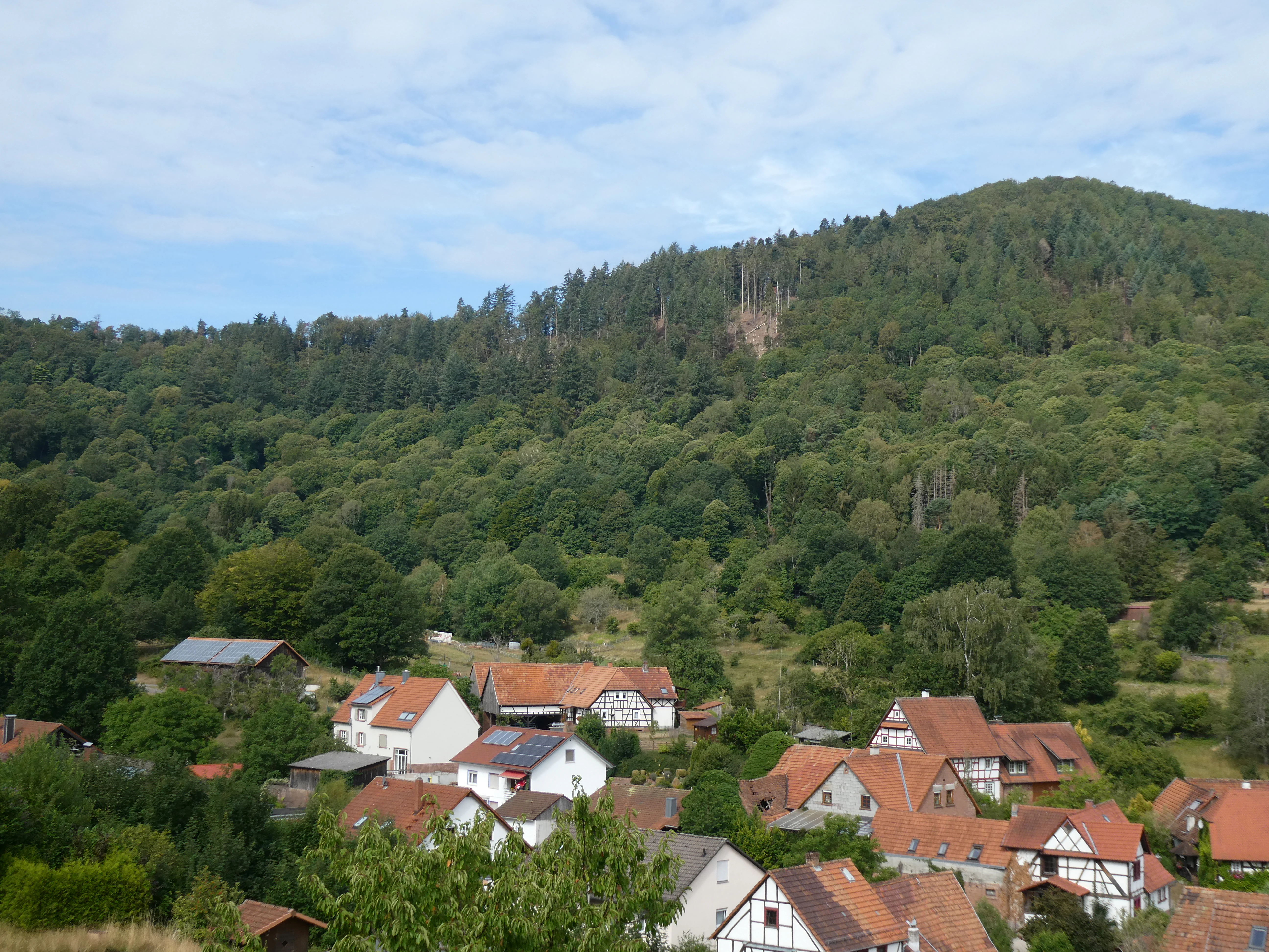
A view of the village of Nothweiler with traditional German timber-framed houses under a forested mountain slope.
The village of Nothweiler nestled at the base of the forested slopes in the Zeppelinhalde nature reserve area.

Zeppelinhalde history and protected-area timeline

Zeppelinhalde was placed under formal nature protection on 1 December 1942, through an ordinance issued by the Reichsstatthalter in der Westmark acting as the higher nature protection authority. The original designation document, preserved as "340-018 Verordnung des Reichsstatthalters in der Westmark," expressly identifies the area as a Wacholderhalde, or juniper hillside, located in the Gemarkung of Nothweiler in what was then the Landkreis Pirmasens.

This early designation reflects a strand of conservation thinking that, during the early to mid-twentieth century, sought to protect distinctive local landscape features such as juniper slopes, heath remnants, and dry grasslands that were being lost through agricultural intensification, afforestation, or natural shrub encroachment. Placing Zeppelinhalde under protection in 1942 effectively froze its juniper-dominated character at a moment when such habitats were locally under pressure from woodland advance on idle slopes.

The reserve has remained in continuous protection since that time. The present administrative boundaries lie within the Landkreis Südwestpfalz, the modern successor to parts of the earlier Landkreis Pirmasens, and the area is today catalogued in the World Database on Protected Areas under WDPA ID 82956. Local press coverage from the year 2000, in Die RHEINPFALZ, described how the small community of Nothweiler has organized its relationship with this nearby natural area, indicating that Zeppelinhalde continued to function as a recognizable local landscape reference at the turn of the twenty-first century.

Zeppelinhalde landscape and geographic character

The landscape of Zeppelinhalde is defined by a sloping hillside on the eastern flank of the Kuhnenkopf, part of the lower spurs of the Palatinate Forest near the German-French border. The reserve occupies a transitional position between the flat valley floor near Nothweiler and the forested ridges above, with elevations on the protected slope ranging broadly from about 350 meters in the north to higher ground approaching the mountain saddle at roughly 441 meters to the south.

To the south and west, the terrain rises more sharply into the prominent peaks of the Wasgau region. The Kuhnenkopf reaches 531 meters, while the nearby Schlossberg, crowned by the Wegelnburg castle ruin, rises to about 570 meters. These summits, along with the intervening saddle, frame Zeppelinhalde visually and ecologically, creating a backdrop of mixed woodland and rocky outcrops that contrasts with the more open, sloping reserved land.

On the eastern side, the protected hillside meets the agricultural mosaic around Nothweiler, where meadows, fields, and small-scale village land use create an open lowland setting. This contrast between active agricultural land and the protected juniper slope is one of the defining visual qualities of the area. To the northwest, the hills continue toward the Brauntal and Königsbruch reserves, while to the southeast the international border with France passes not far from the reserve, anchoring Zeppelinhalde firmly within a cross-border upland landscape shaped by the southern Palatinate Forest and the northern Vosges.

Zeppelinhalde ecosystems, habitats, and plant life

The natural character of Zeppelinhalde is built around its Wacholderhalde, or juniper hillside, habitat. Common juniper dominates or co-dominates the vegetation of the protected slope, forming a semi-open shrub layer that, in classic form, is interspersed with dry grassland species, low herbs, and patches of bare or stony ground. These juniper-rich communities are adapted to warm, well-drained slopes and depend on a regime of relatively low tree cover, often maintained historically through grazing, cutting, or fire.

The reserve represents an important local refuge for this habitat type. Because juniper is slow-growing and does not readily recolonize shaded ground, the loss of open or lightly wooded slopes to dense forest has caused many traditional juniper stands to decline across central Europe. At Zeppelinhalde, protection of the juniper structure with its associated open ground helps maintain a habitat that cannot easily be reinstated once the juniper layer has disappeared.

The mosaic structure is itself a key ecological feature. The reserve combines juniper scrub with the margins of forest above, the meadow edges of Nothweiler below, and the woodland approach toward the mountain saddle, creating within a small area a sequence of dry, warm, semi-open, and more shaded environments. This small-scale ecological diversity supports a wider range of insects, reptiles, and birds than a uniform slope would, and it is a major reason the area has retained its conservation value since 1942. The proximity of the neighbouring Brauntal and Königsbruch reserves further extends this mosaic along the Palatinate border.

Zeppelinhalde wildlife and species highlights

The wildlife character of Zeppelinhalde is closely tied to the juniper hillside and the transition between open slope, shrub layer, and woodland edge. Juniper-dominated slopes are widely recognized as important habitats for warmth-loving invertebrates, including butterflies, wild bees, and other pollinators that depend on open flowering vegetation and the sheltered microclimate of low shrubs.

Small-scale reptile populations, including species associated with dry, stony, shrub-rich slopes in the southern Palatinate, are typical of this habitat type, while the mixture of juniper, grassland remnants, and forest margin also supports a varied bird community. Species that use semi-open, shrub-rich hillsides with adjacent woodland for nesting and foraging are characteristic occupants of the surrounding area, and the proximity of larger continuous forest cover on the Schlossberg and Kuhnenkopf means that the reserve effectively sits at the edge of a richer woodland fauna as well.

Although detailed species inventories for this very small reserve are limited in the public record, the broader ecological context, juniper slope at the interface of meadow and forest, near the French border, suggests that Zeppelinhalde contributes meaningfully to local insect and reptile diversity and to bird habitat continuity along the Palatinate Forest edge.

Zeppelinhalde conservation status and protection priorities

Zeppelinhalde has been a designated nature reserve since 1 December 1942, making it one of the older small-scale protected areas in Rhineland-Palatinate. The original 1942 ordinance specifically identified the site as a juniper hillside worthy of protection, indicating that its conservation value was already recognized more than eighty years ago. The reserve is registered internationally in the World Database on Protected Areas under WDPA ID 82956.

From a conservation perspective, the reserve's significance lies mainly in preserving a habitat type, the Wacholderhalde or juniper hillside, that has become uncommon in the region. Juniper-dominated dry slopes depend on particular combinations of exposure, soil, and openness, and in many places these conditions have been lost through natural forest encroachment or land-use change. By keeping the protected slope open and dominated by juniper, Zeppelinhalde helps maintain not only the shrub layer itself but also the associated flora and fauna of dry, warm, semi-open Palatinate slopes.

The reserve also extends the network of protected habitats along the southern Palatinate border. Its direct neighbourhood with the Brauntal and Königsbruch reserves to the northwest creates a functional corridor of dry slope and valley habitats on the German side of the international boundary, complementing the protected landscapes on the French side of the Wasgau. In this respect, Zeppelinhalde is best understood as both a stand-alone refuge for a rare local habitat and a small but meaningful piece of a larger cross-border conservation landscape.

Zeppelinhalde cultural meaning and human context

Zeppelinhalde sits in the immediate landscape of Nothweiler, a small village in the Landkreis Südwestpfalz whose identity is closely tied to the surrounding slopes. Local media coverage from the year 2000 portrayed how the village relates to the nearby nature reserve, describing Zeppelinhalde in the context of community life and local pride in the surrounding natural setting. This reflects a broader pattern in the southern Palatinate, where small nature reserves are closely integrated with village identity and everyday landscape experience.

The reserve also forms part of the cultural landscape of the Wasgau region, the borderland between the Palatinate Forest and the northern Vosges that has been shaped over centuries by forestry, small-scale agriculture, and cross-border movement. Path networks such as the Fernwanderweg Staudernheim to Soultz-sous-Forêts reflect this long-standing human relationship with the hills, and the presence of castle ruins such as the Wegelnburg on the Schlossberg above the reserve shows how old this settlement and traffic landscape is.

While Zeppelinhalde itself is a natural site rather than a cultural monument, its value is inseparable from the agricultural, village-based, and cross-border character of the human landscape around it. The reserve protects a habitat that has, in effect, co-evolved with local land use, and its continued significance depends on the continued interplay between Nothweiler's fields and meadows and the open juniper slope above it.

Top sights and standout views in Zeppelinhalde

The principal highlight of Zeppelinhalde is its rare juniper hillside habitat, a surviving example of the Wacholderhalde type that was once more widespread on warm Palatinate slopes. The reserve also stands out for its early protection status, having been designated in 1942, and for its position on a transitional slope linking open agricultural land around Nothweiler with the wooded ridges of the Palatinate Forest.

A further distinctive feature is the connectivity of the protected system: Zeppelinhalde forms a near-continuous link with the Brauntal and Königsbruch reserves, and is traversed by a long-distance hiking trail that crosses the international border toward Soultz-sous-Forêts. Together, these qualities make the reserve a small but unusually rich node in the protected landscape of the southern Palatinate border region.

Best time to visit Zeppelinhalde

The Wacholderhalde character of Zeppelinhalde is most visually expressive in late spring and summer, when low juniper growth, dry grassland, and meadow vegetation around Nothweiler come into full development and warm-weather insect activity increases. Walking the reserve in this period gives a clear sense of why the open, sun-exposed slope was singled out for protection in 1942: the contrast between juniper scrub, bright meadow edges, and the dark forest of the ridges above is at its sharpest when foliage is fully developed.

In autumn, the juniper foliage deepens in colour and the surrounding beech and mixed forest of the Palatinate slopes changes tone, while cooler weather typically reduces insect activity, making the visit quieter and more focused on landscape form rather than wildlife. Winter visits are possible along the through-route trail but offer very limited visibility of the habitat structure, since low shrubs and dormant dry grassland are less visually distinctive against the bare woodland. Hikers planning a longer visit that combines Zeppelinhalde with the neighbouring Brauntal and Königsbruch reserves will generally find late spring through early autumn the most rewarding season for experiencing the full juniper-mosaic character of the area.

Monthly climate preview

Long-term temperature and precipitation averages recorded at benchmark coordinates in Rheinland-Pfalz

Zeppelinhalde Climate Normals and Representative Monthly Temperature Rhythms

Representative coordinate records show measured monthly temperature variations spanning from sub-zero winter minimums to warm summer maximums alongside steady precipitation rates. Reviewing the complete twelve-month climatology data provides deeper analytical context on long-term regional weather patterns.
Annual mean10 °C
0 °C20 °C
Jan
Feb
Mar
Apr
May14°
Jun17°
Jul20°
Aug19°
Sep15°
Oct10°
Nov
Dec
Warmest month
July

19.6 °C

Coolest month
January

0.4 °C

Wettest month
December

2.4 mm/day

Driest month
April

1.5 mm/day

Park location guide

Geography guide, regional context, and park location map for Zeppelinhalde

Zeppelinhalde park geography, regions, and map view in Germany

Understand where Zeppelinhalde sits in Germany through a broader geographic reading of the surrounding landscape, nearby location context, and its mapped position within the national park landscape.

How Zeppelinhalde fits into Germany

Germany is a federal republic in Western and Central Europe with a population of over 83 million across sixteen constituent states. It is Europe's largest economy by nominal GDP and a major global exporter and importer. The capital is Berlin, and the country borders Denmark, Poland, Czech Republic, Austria, Switzerland, France, Luxembourg, Belgium, and the Netherlands.

Wider geography shaping Zeppelinhalde in Germany

Germany is located in Western and Central Europe, spanning 357,022 km². It borders Denmark to the north, Poland and the Czech Republic to the east, Austria and Switzerland to the south, and France, Luxembourg, Belgium, and the Netherlands to the west. The country has coastlines on the Baltic Sea and North Sea to the north, with the Alps located in the southern region.

Map view of Zeppelinhalde

Use this park location map to pinpoint Zeppelinhalde in Germany, understand its exact geographic position, and read its mapped placement within the surrounding landscape more clearly.

Pigeon | © OpenStreetMap contributors

Location context for Zeppelinhalde

Rheinland-Pfalz

Visual reference for the rare dry grassland habitats and sloping terrain of the Palatinate Forest

Zeppelinhalde Photos and Landscape Views of the Protected Juniper Hillside

Photographic documentation reveals the rare juniper hillside and sun-exposed slope habitats that define the protected landscape of Zeppelinhalde. Visual exploration provides clear insight into the varied terrain, woodland margins, and transitional vegetation characterizing this southern Palatinate nature reserve.

A view of the village of Nothweiler with traditional German timber-framed houses under a forested mountain slope.

Park atlas

Compare adjacent woodland reserves and connected hillside habitats across the southern Palatinate border.

Explore Other Parks Near Zeppelinhalde and Protected Areas in the Surrounding Region

Continue browsing protected landscapes adjacent to Zeppelinhalde to compare rare juniper hillslopes with surrounding forest reserves. Examining nearby regional parks reveals broader ecological connectivity along the wooded ridges of the Palatinate uplands.
Nature reserveRhineland-Palatinate
About 1.4 km away#1 closest

Northwest

Brauntal Nature Reserve: Protected Wetland Landscapes and Geography in Southern Palatinate

Mapped protected areas in Rhineland-Palatinate, Germany

Brauntal serves as an important nature reserve centered on a dystrophic pond and its surrounding silting zones. The site acts as a critical protected habitat within the Südwestpfalz region, offering insights into wetland ecology, stream headwaters, and hilly transition zones near the French border.

Area
0.71 km²
Established
1984
Nature reserveRheinland-Pfalz
About 3.6 km away#2 closest

West

Königsbruch Nature Reserve: Geographic Map and Protected Landscape Overview

Riparian ecosystems and stream networks in Rheinland-Pfalz

Königsbruch represents a vital conservation landscape in the southern Palatinate Forest, characterized by its damp woodland and the convergence of the Saarbach stream system. Our detailed geographic mapping reveals the protected valley corridors of this nature reserve, providing a clear view of its terrain, hydrological features, and boundary context within the region of Rheinland-Pfalz.

Area
1.226 km²
Established
1996
A pale, soft watercolor illustration depicting a calm lake landscape with green hills, trees, and marshy shoreline on a white background.
Nature reserveRheinland-Pfalz
About 7.3 km away#3 closest

West

Pfälzerwoog Nature Reserve: A Detailed Atlas Overview of Protected Wetland Landscapes in Rhineland-Palatinate

Ecological wetlands within the Palatinate Forest sandstone terrain.

Pfälzerwoog is a protected nature reserve encompassing shallow-water, shoreline, and bog habitats within the Wasgau region of Rhineland-Palatinate. As a distinct hydrological feature in a forest-dominated landscape, the reserve provides a critical look at how rare moist-habitat mosaics survive in the sandy, forested topography near the Franco-German border.

Area
0.113 km²
Established
1979
Relief
Lowland
Climate
Temperate
Nature reserveRheinland-Pfalz
About 7.7 km away#4 closest

Northwest

Wolfsägertal Nature Reserve: Mapped Wetlands and Sandstone Valley Geography

Protected aquatic ecosystems in the Wasgau, Rheinland-Pfalz

Discover the precise geographic footprint and ecological characteristics of Wolfsägertal. This nature reserve, located within the forested sandstone terrain of the Wasgau, provides a concentrated study of stream-side wetland habitats, including the Nollenkopf impoundment and associated fen meadows, all mapped and structured for clear regional context.

Area
0.222 km²
Established
1983
Nature reserveRheinland-Pfalz
About 8.9 km away#5 closest

West

Faunertal Nature Reserve and Palatinate Forest Wetland Mapping

A protected aquatic mosaic in southwestern Germany

Faunertal represents a specialized nature reserve in Rheinland-Palatinate characterized by its chain of abandoned fish ponds along the Dielbach. The site provides a clear case study in landscape transformation, where historic ponds now support diverse sedge mires, reed beds, and complex wetland ecosystems. This area serves as a critical focus for amphibian conservation and habitat connectivity within the broader forest geography of the Palatinate region.

Area
0.253 km²
Established
1983
Nature reserveRhineland-Palatinate
About 10 km away#6 closest

Northwest

Moosbachtal Nature Reserve: Protected Valley Geography and Ecosystem Map in Rhineland-Palatinate

A historic pond and stream mosaic in the southern Palatinate

Moosbachtal stands as a significant protected nature reserve in Rhineland-Palatinate, encompassing a unique 111-hectare mix of sandy slopes, stream-fed meadows, and historic impoundment ponds. This mapped habitat mosaic illustrates the complex successional stages of southern Palatinate forest valleys, offering clear insight into the regional conservation landscape and the connectivity between riparian systems and forested ridges.

Area
1.11 km²
Established
1984
IUCN
IV
Relief
Upland
Nature reserveRheinland-Pfalz
About 11 km away#7 closest

West

Rohrweiher-Rösselsweiher Nature Reserve: Geography and Protected Area Mapping

Wetland and bog landscapes in the Rheinland-Pfalz region

Rohrweiher-Rösselsweiher is a distinctive nature reserve covering 40 hectares of complex wetland, bog, and forest edge habitats. Defined by the convergence of two forest streams, the area functions as a critical component of the regional ecology within the Palatinate Forest. This entry provides mapped insights into the hydrological features and protected land boundaries that define this vital German nature preserve.

Area
0.405 km²
Established
1979
Scope
Terrestrial
Water
Major water bodies
Nature reserveRheinland-Pfalz
About 15 km away#8 closest

Northwest

Wolfslöcher Nature Reserve: Protected Terrain and Regional Geography in Rheinland-Pfalz

Specialized bog and rock habitat analysis within the Palatinate Forest region.

Focusing on its distinctive geological and hydrological profile, this atlas record details the ecological importance of the Wolfslöcher protected area. The site is a concentrated refuge for threatened plant species, featuring a rare combination of alder carr, narrow valley bogs, and spring-loaded sandstone niches that define the character of the southern Palatinate landscape.

Area
0.9 km²
Established
1983

Common questions about visiting, size, designation, and location context for Zeppelinhalde

Zeppelinhalde FAQs for park facts, access, geography, and protected area context

Find quick answers about Zeppelinhalde, including protected-area facts, park geography, trail and visitor context, and how the park fits into its surrounding country and regional landscape.
MoriAtlas Explorer

Continue Your Protected Areas Search Across the Global Atlas

Deepen your exploration by continuing the structured search for national parks and protected areas worldwide. Utilize the comprehensive filtering capabilities to compare different conservation landscapes and refine your understanding of global park geography. Discover more about the distribution and characteristics of protected natural areas.

Global natural geography