

Mori Atlas logo
Nature reserveZollenspieker

Mapping the freshwater tidal mudflats, floodplain forests, and historic brack wetlands

Zollenspieker Nature Reserve: A Detailed Geographic Atlas of Elbe River Tidal Ecosystems

(Naturschutzgebiet Zollenspieker)

Zollenspieker encompasses a protected landscape along the Elbe River within the Hamburg districts of Kirchwerder and Neuengamme. This nature reserve features dynamic freshwater tidal habitats, including mudflats and relict hardwood floodplain forests, contrasted by sheltered inland wetlands formed by historical dike breaches. Explore the complex hydrology of this regional protected area where tidal river channels meet quiet alder carr and species-rich meadow terrains.

tidal floodplainfreshwater tidal habitatElbe rivernature reserveNaturschutzgebietfloodplain forest

Zollenspieker

Nature reserve

Park overview

Structured park overview, official facts, and landscape profile for Zollenspieker Nature Reserve

Zollenspieker Nature Reserve park facts, protected area profile, and essential visitor context

Review the core facts for Zollenspieker Nature Reserve, including designation, size, terrain, visitor scale, habitats, and operating context in one park-focused overview.

About Zollenspieker Nature Reserve

Zollenspieker lies on the northern bank of the Elbe in the southeastern part of Hamburg, between the Kirchwerder and Neuengamme districts. Despite being part of a major city, the reserve preserves genuinely wild stretches of river landscape, combining tidal flooding influence with pockets of older floodplain woodland and quiet backwaters.

The reserve's foreshore sections are dominated by the rhythms of the Elbe tides. Between 100 and 400 meters wide along most of the area, the tidal flats narrow to about 35 meters in the northeast where the dike presses closer to the river. The western part of the foreshore retains fragments of softwater floodplain forest (Auwald) interspersed with freshwater mudflats formed around the stone groynes. To the east, meadows and tall herb vegetation become more prominent, with colorful mown meadows at the foot of the dike supporting species such as false oat-grass (Glatthafer), Deptford pink (Heidenelke), and meadow cranesbill (Wiesenstorchschnabel).

Management of the tidal habitats is active and ongoing. In 1996, a tidal creek (Priel 1) was extended eastward from Zollenspieker Hafen and connected to the mudflat area; in 2003, a second creek (Priel 2) was cut through the groyne line, and the sandy spoil was used to build up a pioneer island opposite Riepenburger Brack, where dry ruderal vegetation and early nutrient-poor grassland have since developed.

Behind the dike, the inland sections reveal an older and quieter face of the landscape. The Carlsbrack and Riepenburger Brack are two shallow wetlands whose exact age is unknown but which are understood to have formed through historic dike breaches. Their open water is largely covered by yellow and white water lilies, with frogbit, and in Carlsbrack also the rare Krebsschere. To the east of Carlsbrack, the Kirchwerder Mühlendamm runs through a wooded area whose southern portion preserves a relic of the original oak-dominated hardwood floodplain forest (Hartholzauwald), flanked by a wetter alder carr. During high water on the Elbe, these forests can be flooded by seepage water (Qualmwasser), maintaining their wetland character.

Taken together, Zollenspieker is a compact but ecologically rich reserve that captures two complementary faces of the Elbe: a living, managed tidal edge and a set of sheltered inland wetlands with deep natural and cultural roots.

Quick facts and research context for Zollenspieker Nature Reserve

Zollenspieker is a nature reserve (Naturschutzgebiet) located south of Kirchwerder on the northern bank of the Elbe within the city-state of Hamburg. It occupies about 80 hectares and consists of three separate sections: roughly 64 hectares of tidal foreshore outside the dike and about 13 hectares of inland areas behind it, including the Carlsbrack, Riepenburger Brack, and the Riepenburger Vogelschutzgehölz.

The reserve has been legally protected since 26 April 1988 and is managed with involvement from the Hamburg state branch of NABU (Naturschutzbund Deutschland). Together with the neighboring Kiebitzbrack reserve, it forms the FFH site Zollenspieker/Kiebitzbrack, which was designated in 1998. It is classified as an IUCN Category IV area focused on habitat and species management.

Protection and recognition

Examine documented terrestrial boundaries and official conservation data for Zollenspieker.

Zollenspieker Protection Status and International Recognition Records

Zollenspieker maintains a recorded terrestrial protection scope within global conservation databases. Systematic review reveals verified administrative classifications and formal designation metrics without external recognition sources.

Protection details

Protection scope
Terrestrial
Transboundary protection
No
WDPA ID
166425
Park context

Deeper park guide and search-rich context for Zollenspieker Nature Reserve

Zollenspieker Nature Reserve history, landscape, wildlife, and travel context

Explore Zollenspieker Nature Reserve through its history, landscape character, ecosystems, wildlife, conservation priorities, cultural context, and seasonal travel timing in a structured park guide built for atlas discovery and search intent.

Why Zollenspieker Nature Reserve stands out

Zollenspieker is best known for its freshwater tidal ecosystem along the Elbe, where tidal flats, riparian woodland remains, and species-rich meadows meet Europe's last major tidal river. The reserve holds around 150 plant species on its tidal floodplain, including the Elbe-Rasenschmiele and the endemic Schierlings-Wasserfenchel, which is restricted to the freshwater tidal zone of the Elbe. The inland sections add another layer of interest: the Carlsbrack and Riepenburger Brack, two wetlands of uncertain age formed by historic dike breaches, are surrounded by reedbeds, water lily cover, oak-dominated hardwood floodplain relics, and alder carr. This combination of dynamic river habitats and sheltered inland wetlands gives Zollenspieker its distinctive character.
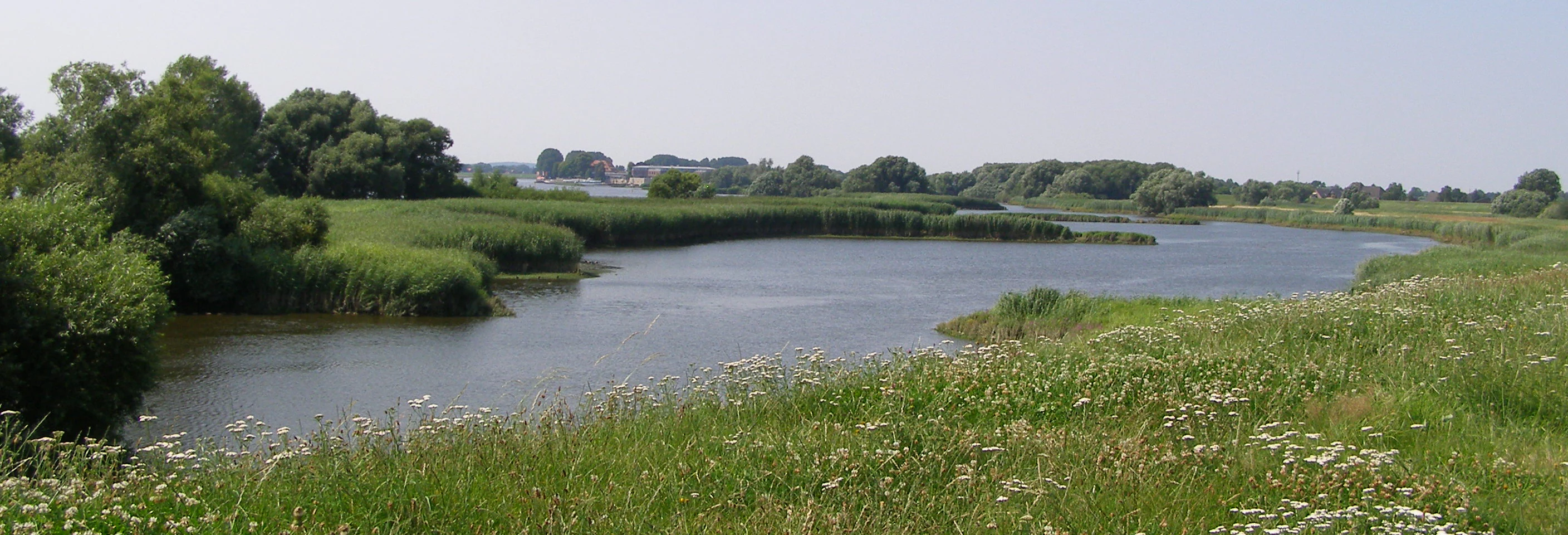
Zollenspieker Nature Reserve tidal creek
A tidal creek in the Zollenspieker nature reserve with the Zollenspieker ferry house in the background

Zollenspieker Nature Reserve history and protected-area timeline

The area that is now the Zollenspieker Nature Reserve gained formal protection on 26 April 1988, when it was officially designated as a Naturschutzgebiet under Hamburg law. The inland wetland features of the reserve, including the Carlsbrack and Riepenburger Brack, are understood to have originated from dike breaches that occurred in previous centuries, although the precise dates of these events remain undocumented.

In the years following designation, active habitat management was taken up. In 1996, a tidal creek named Priel 1 was extended eastward from Zollenspieker Hafen to reconnect inland waters with the tidal flats. A second intervention followed in 2003, when Priel 2 was opened through the groyne line to enhance tidal exchange; the sandy material excavated during this work was deposited to form a pioneer island opposite Riepenburger Brack.

A broader conservation milestone came in 1998, when Zollenspieker, together with the neighboring Kiebitzbrack reserve, was formally proposed as a European Fauna-Flora-Habitat (FFH) site under the EU Habitats Directive. The reserve is supervised by Hamburg's BSU (Behörde für Stadtentwicklung und Umwelt), now part of the city's environmental administration, and its on-the-ground stewardship is led by the Hamburg state branch of NABU.

Zollenspieker Nature Reserve landscape and geographic character

The landscape of Zollenspieker is shaped first and foremost by the tidal Elbe. The river runs along the southern edge of the reserve, and the dikes built to control it cut the area into two contrasting zones: a dynamic river-facing floodplain outside the dike and calmer, lower-lying wetlands and woodlands behind it.

Outside the dike, the foreshore varies in width from roughly 100 to 400 meters, narrowing to about 35 meters in the northeast. Stone groynes extend into the river, and between them lie freshwater mudflats (Süßwasserwatten) exposed at low tide. Toward the western end of the reserve, fragments of softwater floodplain forest cling to the higher ground among the groynes; toward the east, open meadows and tall herb communities (Hochstaudenfluren) take over, with flowery mowing meadows at the foot of the dike providing seasonal color.

The inland landscape is quieter and more intimate. The Carlsbrack and Riepenburger Brack are the reserve's central inland features: shallow, still-water wetlands bordered by reedbeds, shrubs, and woodland. To the east of Carlsbrack lies a forested strip crossed by the Kirchwerder Mühlendamm, where a relic oak-dominated hardwood floodplain forest gives way to a wetter alder carr in the north. During high Elbe water levels, seepage water (Qualmwasser) can flood these inland forests, linking their hydrology back to the nearby river.

Zollenspieker Nature Reserve ecosystems, habitats, and plant life

The ecological character of Zollenspieker is defined by the meeting of two habitats: an active freshwater tidal floodplain along the Elbe and a series of more sheltered inland wetlands and woodlands protected behind the dike.

The tidal floodplain supports around 150 plant species, many of them adapted to regular inundation and tidal exposure. Among the notable plants are the Elbe-Spitzklette, annual mugwort (Einjähriger Beifuß), the Elbe-Rasenschmiele (Deschampsia wibeliana), which is largely restricted to the Elbe, and the Schierlings-Wasserfenchel, an endemic species confined to the freshwater tidal zone of the Elbe. Mown meadows at the dike foot add further botanical interest with species like Glatthafer, Heidenelke, and Wiesenstorchschnabel.

The inland sections host a different ecological community. The open water of Carlsbrack and Riepenburger Brack is largely covered by yellow and white water lilies, with frogbit and, in Carlsbrack, the rare Krebsschere. The southern wooded area east of Carlsbrack preserves a relic Hartholzauwald dominated by pedunculate oak, transitioning northward into a wet, sometimes flooded alder carr. Where the Riepenburger Brack connects north via a ditch to the Kraueler Sammelgraben, the ditch widens into small ponds flanked by encroaching reedbeds.

Together, these habitats form a compact but ecologically layered patchwork: dynamic tidal edge, sheltered inland waters, species-rich meadows, and relict floodplain forest, all within a single small Hamburg reserve.

Zollenspieker Nature Reserve wildlife and species highlights

Zollenspieker supports a rich mix of bird life drawn to both its tidal flats and its inland meadows and woodland. Wading birds typical of wet grasslands and tidal edges can be found here, including snipe (Bekassine), black-tailed godwit (Uferschnepfe), and common redshank (Rotschenkel). The mosaic of meadows, hedges, woodland edges, and riparian habitats also supports kingfisher (Eisvogel), golden oriole (Pirol), wryneck (Wendehals), meadow pipit (Wiesenpieper), melodious warbler (Gelbspötter), wood warbler (Waldlaubsänger), lesser spotted woodpecker (Kleinspecht), and marsh harrier (Rohrweihe).

The tidal flats and shallow waters serve as important feeding, gathering, and resting areas for waterfowl. Present species include goosander (Gänsesäger), common shelduck (Brandgans), Eurasian teal (Krickente), and a wide variety of other waterbirds and shorebirds (Limikolen).

Tidal creeks, channels, and shallow water areas also provide habitat and spawning grounds for fish such as bitterling, twaite shad (Finte), river lamprey, sea lamprey, asp (Rapfen), European weatherfish (Schlammpeitzger), spined loach (Steinbeißer), and the Baltic whitefish (Ostseeschnäpel). Insects, dragonflies, grasshoppers, butterflies, and mollusks add further biodiversity, with notable species including Keilfleck-Mosaikjungfer and Fledermaus-Azurjungfer dragonflies, the Große Goldschrecke and Sumpfschrecke grasshoppers, the Braunfleckiger Perlmuttfalter and Spiegelfleck-Dickkopffalter butterflies, and snails such as the Bauchige Windelschnecke and the Zierliche Tellerschnecke.

Zollenspieker Nature Reserve conservation status and protection priorities

Zollenspieker was designated as a Naturschutzgebiet in 1988 and is classified as a Category IV IUCN protected area, focused on habitat and species management. Its core conservation goal is to maintain the integrity of a stretch of freshwater tidal habitat on the Elbe: a habitat type that is increasingly rare in Europe's heavily regulated river systems.

Since designation, active management has shaped the reserve. The 1996 extension of Priel 1 and the 2003 creation of Priel 2, along with the construction of the pioneer island from excavated sand, were designed to enhance tidal exchange and create new successional habitats such as dry ruderal vegetation and early nutrient-poor grassland. Inland, the relics of Hartholzauwald and the alder carr are protected as living reminders of the Elbe's historic floodplain forest cover.

In 1998, Zollenspieker, together with the neighboring Kiebitzbrack reserve, was designated as an FFH (Fauna-Flora-Habitat) site under the EU Habitats Directive, embedding it into the European network of protected nature areas. The reserve is supervised by Hamburg's BSU and is actively stewarded on the ground by the Hamburg branch of NABU, which monitors the site and coordinates conservation work.

Zollenspieker Nature Reserve cultural meaning and human context

Zollenspieker's inland wetlands, especially the Carlsbrack and Riepenburger Brack, are understood to have originated from historic dike breaches along the Elbe. These breaches, caused when the river overtopped or broke through flood defenses in earlier centuries, left behind shallow depressions that filled with water and gradually evolved into the reed-fringed, water-lily-covered brack wetlands seen today.

The reserve's surroundings reflect a long-established rural and cultural landscape within Hamburg's Vier- und Marschlande region. Inland sections of the reserve are bordered primarily by agricultural land, with occasional residential development pressing close to its edges. Local roads such as the Kirchwerder Mühlendamm reflect historic route lines through this traditionally diked and farmed Elbe margin countryside. The zone of Kirchwerder and Neuengamme where the reserve sits preserves elements of the older working Elbe marshland within the broader city.

Top sights and standout views in Zollenspieker Nature Reserve

Zollenspieker's standout features include roughly 64 hectares of active tidal floodplain along the Elbe, with freshwater mudflats, groyne fields, softwater floodplain forest remnants, and meadows rich in flowering plants at the dike foot. Active habitat work, especially the Priel 1 and Priel 2 creek restorations and the pioneer island construction, has created new successional habitats and a focal zone for rare Elbe-restricted plants such as the Schierlings-Wasserfenchel.

Behind the dike, two old brack wetlands (Carlsbrack and Riepenburger Brack), together with a relic Hartholzauwald and adjacent alder carr, offer a quieter, more sheltered counterpart to the tidal edge. The reserve's combination of dynamic freshwater tidal habitat, inland brack wetlands, traditional meadows, and relict floodplain forest, packed into just 80 hectares within Hamburg, makes it an unusually compact showcase of Elbe valley ecology.

Best time to visit Zollenspieker Nature Reserve

Zollenspieker is best appreciated in the warmer months, when tidal exposure, flowering meadows, and bird activity are most visible. Late spring through early summer brings the richest display on the dike-foot mowing meadows, with species like Glatthafer, Heidenelke, and Wiesenstorchschnabel in bloom. Summer also favors active dragonfly and butterfly populations in the wetter sections and along the meadow edges.

Migration and breeding seasons generally make spring and early summer productive for birdwatching, while the inland brack wetlands and reedbeds invite quiet observation along their margins. In cooler seasons, the reserve's compact size and varied habitats mean that even shorter visits can offer a clear sense of its mixed tidal and inland character; visitors interested in migratory waterfowl on the Elbe's flats are likely to find that period especially rewarding.

Monthly climate preview

Long-term representative measurements and monthly weather patterns for Zollenspieker

Zollenspieker Climate Normals, Annual Temperature and Precipitation Rhythms

Zollenspieker maintains measured long-term averages tracking monthly temperature variations and precipitation totals across representative coordinates. Examining the complete twelve-month record reveals detailed annual weather rhythms, average minimums, and maximum temperature progressions.
Annual mean9 °C
1 °C18 °C
Jan
Feb
Mar
Apr
May13°
Jun16°
Jul18°
Aug18°
Sep14°
Oct
Nov
Dec
Warmest month
July

18 °C

Coolest month
January

0.5 °C

Wettest month
July

2.6 mm/day

Driest month
April

1.4 mm/day

Park location guide

Geography guide, regional context, and park location map for Zollenspieker Nature Reserve

Zollenspieker Nature Reserve park geography, regions, and map view in Germany

Understand where Zollenspieker Nature Reserve sits in Germany through a broader geographic reading of the surrounding landscape, nearby location context, and its mapped position within the national park landscape.

How Zollenspieker Nature Reserve fits into Germany

Germany is a federal republic in Western and Central Europe with a population of over 83 million across sixteen constituent states. It is Europe's largest economy by nominal GDP and a major global exporter and importer. The capital is Berlin, and the country borders Denmark, Poland, Czech Republic, Austria, Switzerland, France, Luxembourg, Belgium, and the Netherlands.

Wider geography shaping Zollenspieker Nature Reserve in Germany

Germany is located in Western and Central Europe, spanning 357,022 km². It borders Denmark to the north, Poland and the Czech Republic to the east, Austria and Switzerland to the south, and France, Luxembourg, Belgium, and the Netherlands to the west. The country has coastlines on the Baltic Sea and North Sea to the north, with the Alps located in the southern region.

Map view of Zollenspieker Nature Reserve

Use this park location map to pinpoint Zollenspieker Nature Reserve in Germany, understand its exact geographic position, and read its mapped placement within the surrounding landscape more clearly.

Pigeon | © OpenStreetMap contributors

Location context for Zollenspieker Nature Reserve

Hamburg

Explore protected area views, freshwater mudflats, and relict floodplain forest habitats.

Zollenspieker Photos and Scenery: Visualizing the Elbe Tidal Floodplain

Visual documentation reveals the dynamic freshwater tidal ecosystems and sheltered inland wetlands defining this unique protected landscape along the Elbe river. Examining these detailed photographic records helps researchers and naturalists understand complex riparian habitats, mudflats, and native vegetation zones more thoroughly.

Zollenspieker Nature Reserve tidal creek

Carlsbrack

Park atlas

Compare surrounding regional nature reserves and connected wetland habitats.

Explore Protected Areas and Parks Near Zollenspieker Along the Elbe River

Browse other protected areas near Zollenspieker to examine related freshwater tidal habitats, floodplain forests, and river valley ecosystems. Continuing into regional park comparisons reveals broader ecological patterns across the surrounding landscape.
Nature reserveLower Saxony
About 8.2 km away#1 closest

West

Stemmbruch Nature Reserve: Protected Lowland Bog Geography in Lower Saxony, Germany

A resilient moorland habitat near the Seeve floodplain

Stemmbruch serves as a vital nature reserve in the Harburg district, protecting a rare hanging spring bog system. This compact protected area features a mosaic of bog pools, heath, and swamp woodland, demonstrating the complex hydrologic connectivity between the sandy geest ridge and the surrounding northern German lowland plains.

Area
0.56 km²
Established
1989
IUCN
IV
Relief
Lowland
Nature reserveLower Saxony
About 13 km away#2 closest

Southeast

Wittsaal Nature Reserve: Mapped Wetland Geography and Protected Landscape in Lower Saxony

A rare mosaic of moor ponds and swamp woodland

Wittsaal is a specialized nature reserve in the Lüneburg region of Lower Saxony, Germany. The area protects a peat-cut moor pond currently undergoing natural silting, surrounded by willow-dominated swamp woodland, reedbeds, and sedge marshes. This compact site provides a critical, quiet refuge for wetland ecology within a wider landscape of agricultural fields and transitional glacial terrain.

Area
0.13 km²
Established
1985
IUCN
IV
Relief
Lowland
Nature reserveHamburg
About 14 km away#3 closest

Northwest

Schweenssand Nature Reserve: Protected Elbe Floodplain Geography in Hamburg Germany

Tidal freshwater wetlands, reedbeds, and riverine forest mosaics

Spanning 35 hectares along the Süderelbe, Schweenssand acts as a vital protected area within the Hamburg city boundary. Its geography consists of freshwater tidal flats, mudflats, and ancient-looking floodplain forests that are continuously shaped by the Elbe river tide. This site offers a clear view into the ecological complexity of urban-fringe river landscapes and European Natura 2000 protected zones.

Area
0.4 km²
Established
1993
IUCN
IV
Relief
Lowland
Nature reserveLower Saxony
About 20 km away#4 closest

Southeast

Streitmoor Nature Reserve Geography and Mapped Protected Land in Lower Saxony

A study in compact bog and wetland succession

Streitmoor provides a detailed look at a terrestrialized pond moor within the Lüneburg district. The site contains a layered sequence of peat mosses, cottongrass, and woodland, mapping the natural transition between open bog basins and dry forest margins in northwestern Germany.

Area
0.13 km²
Established
1972
IUCN
IV
Relief
Lowland
Nature reserveLandkreis Harburg
About 24 km away#5 closest

West

Wulmstorfer Heide mit Bornberg: Protected Nature Reserve and Glacial Landscape Map

Regional geography and habitat network in Landkreis Harburg, Lower Saxony

This protected area features a unique mosaic of dry heath, nutrient-poor grassland, and mature broadleaf woodland. Located near the Hamburg border, it provides an essential habitat refuge within the Harburger Berge, characterized by sandy glacial soils and former military training terrain that supports specialized reptiles, amphibians, and bird species.

Area
2.72 km²
Established
2024
IUCN
IV
Relief
Upland
Protected landscapeLower Saxony
About 31 km away#6 closest

Southwest

Naturpark Lüneburger Heide: Protected Landscape Map and Regional Geography

An expansive cultural landscape in northern Lower Saxony

Spanning over 1,000 square kilometers, Naturpark Lüneburger Heide preserves the largest contiguous inland heathlands in Central Europe. Use this atlas resource to understand the park's glacial terrain, including karst sinkholes and natural springs, as well as its status as a model region for sustainable conservation and traditional land management practices.

Area
1,097.85 km²
Established
1922
IUCN
V
Relief
Lowland
Nature reserveUelzen District
About 34 km away#7 closest

Southeast

Vierenbach Nature Reserve: Landscape Geography and Protected Area Mapping in Uelzen District

A study of lowland stream valleys and swamp forest ecosystems.

Vierenbach serves as a crucial lowland stream sanctuary in the Uelzen District, featuring a concentrated variety of alder and ash swamp forests, birch bog woodlands, and wet fen grasslands. This entry offers a deep look into the reserve's unique transition zones between waterlogged valley floors and drier oak-hornbeam Geest slopes.

Area
2.3 km²
Established
2004
IUCN
IV
Nature reserveLandkreis Uelzen
About 38 km away#8 closest

South

Wettenbosteler Moor Protected Area: Geographic Overview and Mapped Landscape Features

A resilient raised bog remnant in the Landkreis Uelzen heath forest

Spanning roughly thirteen hectares, Wettenbosteler Moor preserves a rare spring-fed bog habitat characterized by peat-forming vegetation and pine forest borders. This nature reserve offers deep insights into the drainage networks and lowland terrain of the Lüneburg Heath, mapping the transition between upland forest and valley mire.

Area
0.128 km²
Established
1977
IUCN
IV
Relief
Lowland

Common questions about visiting, size, designation, and location context for Zollenspieker Nature Reserve

Zollenspieker Nature Reserve FAQs for park facts, access, geography, and protected area context

Find quick answers about Zollenspieker Nature Reserve, including protected-area facts, park geography, trail and visitor context, and how the park fits into its surrounding country and regional landscape.
MoriAtlas Explorer

Continue Your Protected Areas Search Across the Global Atlas

Deepen your exploration by continuing the structured search for national parks and protected areas worldwide. Utilize the comprehensive filtering capabilities to compare different conservation landscapes and refine your understanding of global park geography. Discover more about the distribution and characteristics of protected natural areas.

Global natural geography