
Mori Atlas logo
Nature reserveAlte Fulda bei Asbach

Tracing the mapped boundaries and natural floodplain features of this vital oxbow reserve

Alte Fulda bei Asbach: Protected River Floodplain and Wetland Geography in Hesse, Germany

(Naturschutzgebiet Alte Fulda bei Asbach)

Alte Fulda bei Asbach functions as a critical protected nature reserve within the middle Fulda valley in Hesse. The site preserves a rare, near-natural oxbow lake alongside essential wet meadows, reedbeds, and softwood forest mosaics. Through mapped boundaries and topographic analysis, the area provides a window into the evolution of Central European river floodplains and their role in maintaining regional biodiversity.

nature reserveoxbowfloodplainstill waterwet meadowreedbed
A flat-style digital illustration showing a calm lake filled with water lily pads in the foreground, surrounded by trees and reeds, with a large, flat-topped mountain peak rising in the distance under a pastel sky.

Alte Fulda bei Asbach

Nature reserve

Park overview

Structured park overview, official facts, and landscape profile for Alte Fulda bei Asbach Nature Reserve

Alte Fulda bei Asbach Nature Reserve park facts, protected area profile, and essential visitor context

Review the core facts for Alte Fulda bei Asbach Nature Reserve, including designation, size, terrain, visitor scale, habitats, and operating context in one park-focused overview.

About Alte Fulda bei Asbach Nature Reserve

Alte Fulda bei Asbach is a small but ecologically dense nature reserve in northern Hesse, about twenty hectares or less of protected land that captures an entire floodplain landscape in miniature. The reserve is named after the old arm of the Fulda river that still holds open water here, surrounded by a fringe of willows, alders, and slow-silting reedbeds. Although the protected area covers roughly twelve hectares, it preserves a sequence of habitats that has become rare in central Germany: open standing water with floating-leaf plants, softwood floodplain forest along the banks, and wet meadows that grade into the surrounding lowland.

The Fulda river flows along the eastern edge of the reserve, and during high water it still connects to the old arm through a flood channel, recalling a time when the river actively shaped this valley. The reserve lies in the Hersfelder Senke, a natural region within the larger Osthessisches Bergland, and is bordered to the west by the Kirchheimer Bergland and to the east by the Buchenauer Hochfläche. Its soil profile reflects the long history of the Fulda floodplain: layers of gravel and sand from the ice ages were later overlaid by thick deposits of Auenlehm, the flood loam that farmers have worked here since the Middle Ages.

Established as a Naturschutzgebiet in January 1984, the reserve is formally one of the small protected sites of the Landkreis Hersfeld-Rotenburg. Yet through its inclusion in larger Natura 2000, bird protection, and landscape protection networks, it functions as a piece of a much broader conservation effort for the Fulda floodplain. Today the site is valued both for what it still preserves and for what it illustrates about the dynamic relationship between a river and its valley.

Quick facts and research context for Alte Fulda bei Asbach Nature Reserve

Alte Fulda bei Asbach is a Hessian nature reserve of about 12 hectares, established in January 1984 and managed under IUCN Category IV. It lies on the western bank of the Fulda in the Hersfelder Senke natural region, southeast of Asbach, a district of the city of Bad Hersfeld.

The site protects a partially silted oxbow together with a buffer of surrounding grasslands. It is integrated into the Obere und Mittlere Fuldaaue Natura 2000 site, the Fuldatal zwischen Rotenburg und Niederaula EU Bird Protection Area, and the Auenverbund Fulda landscape protection area. Coordinates: approximately 50.83° N, 9.67° E, at around 202 meters above sea level.

Protection and recognition

Terrestrial conservation framework, establishment year, and official records

Alte Fulda bei Asbach Protection Status and Designation History

Alte Fulda bei Asbach holds a documented terrestrial protection status established in nineteen eighty four. Conservation records outline the management scope and official designation history for this protected area.

Protection details

Protection scope
Terrestrial
Designated year
1984
Transboundary protection
No
WDPA ID
162087
Park context

Deeper park guide and search-rich context for Alte Fulda bei Asbach Nature Reserve

Alte Fulda bei Asbach Nature Reserve history, landscape, wildlife, and travel context

Explore Alte Fulda bei Asbach Nature Reserve through its history, landscape character, ecosystems, wildlife, conservation priorities, cultural context, and seasonal travel timing in a structured park guide built for atlas discovery and search intent.

Why Alte Fulda bei Asbach Nature Reserve stands out

Alte Fulda bei Asbach is best known as one of the few larger near-natural still waters left in the middle Fulda valley, with a rich mosaic of floating-leaf vegetation, softwood floodplain forest, reedbeds, and wet meadows. It is also recognized for its importance for endangered floodplain species, including the Dark Large Blue butterfly, a threatened insect whose caterpillars depend on the Great Burnet that grows in the reserve's meadows. The combination of an old oxbow, intact bankside willow and alder growth, and species-rich wet grassland makes the site a representative example of a Central European river floodplain in a remarkably compact form.
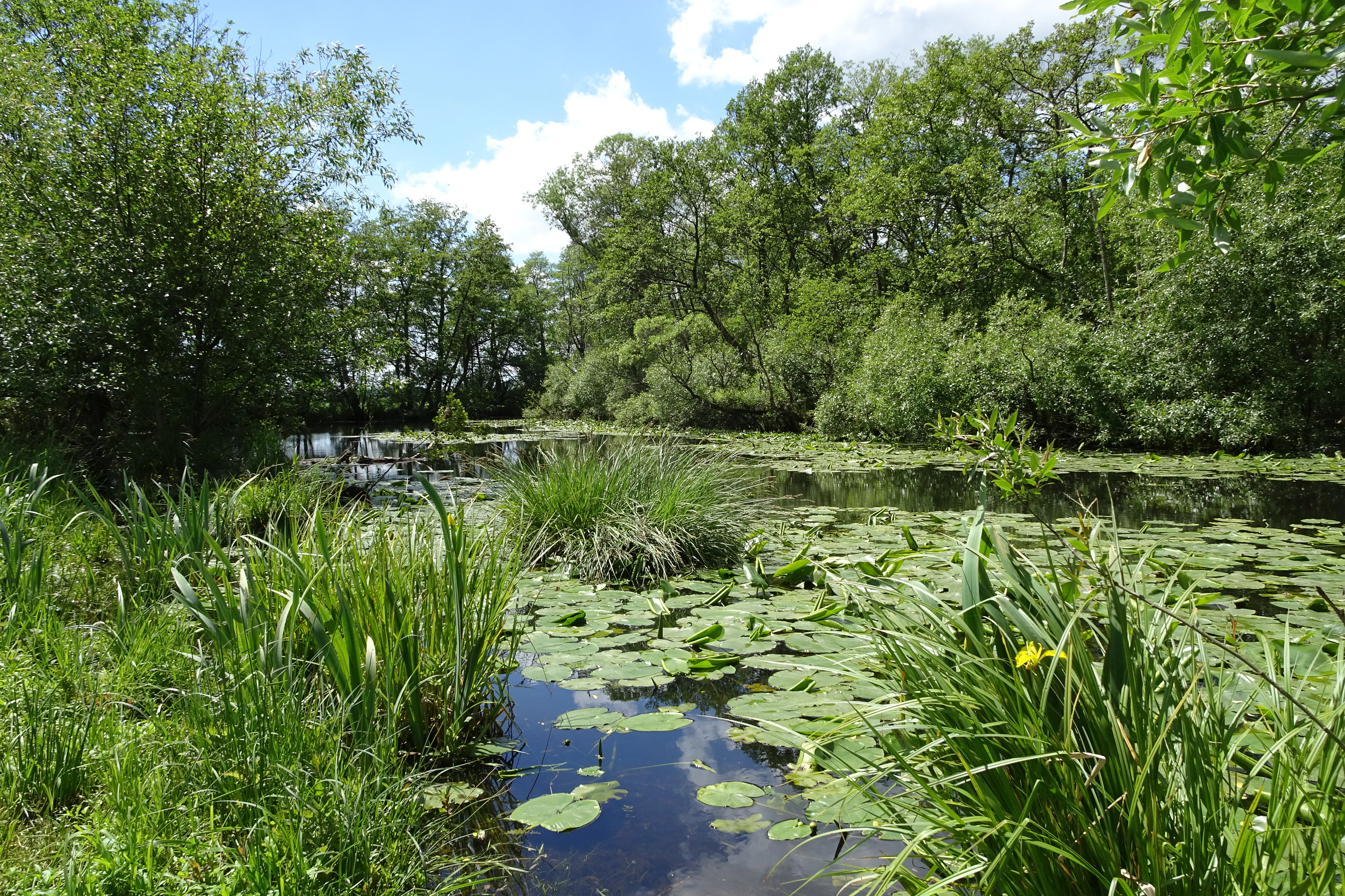
An oxbow lake covered in water lily pads, surrounded by dense green trees and tall marsh grasses on a bright day.
A view of the oxbow lake at the Alte Fulda bei Asbach nature reserve, featuring water lilies and lush riparian vegetation.

Alte Fulda bei Asbach Nature Reserve history and protected-area timeline

The protected area has a relatively recent administrative history but a much older ecological one. The oxbow that gives the reserve its name was gradually cut off from the Fulda's main course as the river shifted and as meanders lost their connection to the active channel. Over centuries, the still water filled with aquatic plants, reed encroached from the margins, and a softwood floodplain of willows and alders developed along its banks.

The surrounding landscape was already heavily altered by the early Middle Ages. Deforestation, settlement expansion, and the spread of grazing land into the swampy floodplain reduced the original Auwald, while soil erosion from cleared slopes washed metres of sediment into the lowlands. By the High Middle Ages the maximum extent of cultivated land was reached; agriculture in the floodplain has remained roughly the same in extent ever since, though its intensity has grown with modern machinery and silage production.

In modern times, the ecological significance of the old arm and its meadows drew sustained attention from conservation authorities. On 10 January 1984, the Bezirksdirektion für Forsten und Naturschutz at the Kassel regional government issued a formal regulation declaring the Alte Fulda bei Asbach a Naturschutzgebiet. The purpose was to safeguard the oxbow, its rich flora and fauna, and the population of endangered bird and aquatic plant species it supported, while keeping the surrounding grasslands as a buffer. In 2008 the site's status was further strengthened when it became part of the larger Natura 2000 FFH site Obere und Mittlere Fuldaaue.

Alte Fulda bei Asbach Nature Reserve landscape and geographic character

The reserve sits in the lowlands of the middle Fulda valley, where the Fulda river, on its long course toward the Weser, has cut through layers of Lower and Middle Bunter Sandstone. The river still defines the eastern edge of the protected area; during flood events the Fulda connects to the oxbow through a shallow flood channel, briefly reasserting its relationship with the older channel.

The floodplain sediments tell the story of an evolving landscape. Cold-phase gravel terraces were laid down during the ice ages when the river ran low, while warmer periods saw the Fulda cut down again into its own deposits. From the Neolithic onward, renewed soil erosion from newly cleared farmland produced the thick loam blankets, or Auenlehm, that now dominate the surface. Small depressions where groundwater lies near the surface have developed Gley soils, and the prevailing soil type across much of the floodplain is the Braune Auenboden, also called Vega.

The topography is gentle but pronounced enough to shape local climate. Because the valley floor stays slightly cooler and damper than the surrounding hills, the average temperature is only about one degree higher than the surrounding uplands, while calm autumn and winter nights can trap cold air in low pockets, leading to early and late frosts. The relief around the reserve, namely the Kirchheimer Bergland to the west and the Buchenauer Hochfläche to the east, frames a quiet, low-lying basin that has long been shaped by water.

Alte Fulda bei Asbach Nature Reserve ecosystems, habitats, and plant life

Ecologically, the reserve is a small but exceptionally complete example of a Central European river floodplain. At its heart is the Alte Fulda, a partially silted oxbow whose remaining open water is dominated by floating-leaf communities including the Yellow Water-lily and small duckweed species. The wet fringes support Purple Willow thickets and reedbeds of Water Sweet-grass, while the banks carry the classic softwood floodplain forest of willows and alders.

Beyond the water, the floodplain meadows are equally important. The Hessian biotope survey classifies the grassland here into moderately dry meadows, wet meadows, and abandoned wet fallows overgrown with tall herb vegetation. Although intensive silage-oriented farming has expanded, traditionally managed wet meadows still survive, and on land no longer profitable to farm, wet fallows and tall-herb communities are actually gaining space. Together with the Auenlehm soils, these meadows support several plant species that are considered endangered in Hesse, including the Sedge-Carex sedge group and other moisture-loving specialists.

The reserve illustrates a classic hydrosere, that is, the natural slow infilling of a still water body. Aquatic plants reduce the open water surface, dead plant material accumulates into a thickening humus layer, reed and sedge encroach from the margins, woody species establish themselves, and if left undisturbed, the sequence would end in closed floodplain forest. At Alte Fulda, this succession has already converted much of the original channel into marsh and willow scrub, and the protected area captures several stages at once.

Alte Fulda bei Asbach Nature Reserve wildlife and species highlights

More than ninety bird species have been recorded in or near the reserve. Protected under the EU Birds Directive are species such as Hen Harrier, Black Kite, Common Tern, Kingfisher, and Red-backed Shrike, which have been seen resting or feeding in the area. In the reeds and softwood fringes breed Water Rail, Lesser Spotted Woodpecker, Grasshopper Warbler, and Icterine Warbler, while the meadows and fallows support Grey Partridge and Skylark.

In the grasslands, the meadows' tall Great Burnet plants sustain a particularly important population of the Dark Large Blue butterfly, a species considered threatened across Europe and treated as a key indicator for conservation. Because this butterfly depends entirely on the presence of its specific food plant and the right mowing regime, the reserve is regarded as a significant reproduction site for the species.

Information panels at the site also record fourteen butterfly species, twelve dragonfly species, three amphibian species, and eight grasshopper species confirmed in 1996. The reserve is therefore a notable hotspot for invertebrates as well as birds, reflecting the diversity of habitats fitting into a very small area.

Alte Fulda bei Asbach Nature Reserve conservation status and protection priorities

The reserve's conservation significance lies in the layered protection of a representative Middle Fulda floodplain. Designation in 1984 as a Naturschutzgebiet gave it core legal protection, and the surrounding meadows were included as a buffer, although limited traditional agricultural use continues. Pesticide use is prohibited, but mowing and grazing on the established grasslands are still permitted within existing limits.

Integration into three larger conservation frameworks greatly extends the site's importance. As part of the Obere und Mittlere Fuldaaue Fauna-Flora-Habitat site, it contributes to the European Natura 2000 network, supporting floodplain dynamics, species-rich meadows, near-natural bankside woodlands, and the characteristic still waters of the Fulda floodplain across more than 2,500 hectares. The Fuldatal zwischen Rotenburg und Niederaula EU Bird Protection Area links it to roughly 1,700 hectares of bird habitat along the river, with the Alte Fulda itself acting as a core zone alongside other neighbouring reserves. Finally, the Auenverbund Fulda landscape protection area, designated in 1993, ties the site into a wider strategy of preserving diverse moisture-dependent meadow and riverside vegetation and converting arable land back into extensively managed grassland.

For species like the Dark Large Blue butterfly, Kingfisher, Hen Harrier, and several endangered plant species of wet meadows, the reserve is a small but reliable refuge and breeding ground. It preserves not only individual species but also the ecological processes of the floodplain.

Alte Fulda bei Asbach Nature Reserve cultural meaning and human context

The reserve does not contain notable buildings, monuments, or settlements, and its cultural dimension is primarily that of a long-standing agricultural floodplain rather than a place of historical buildings. The Auenlehm soils and the wet meadows, however, carry the imprint of centuries of farming: clearance of the original Auwald in the early Middle Ages, soil erosion from newly deforested slopes, and the gradual expansion of pasture and, later, silage production that intensified management from the modern era onward.

This quiet valley near Asbach, a village that today belongs to Bad Hersfeld, has therefore long been a place where human activity and natural floodplain dynamics have coexisted, if unevenly. The decision to protect the Alte Fulda in 1984 reflects a regional recognition that the surviving patch of old channel and species-rich meadows has cultural as well as ecological value, because it preserves a glimpse of how the Fulda valley once looked before modern intensive land use took hold.

Top sights and standout views in Alte Fulda bei Asbach Nature Reserve

The reserve's most striking features include the still half-open oxbow with extensive floating-leaf vegetation and the surrounding banks of willow and alder, which together form one of the few near-natural still waters in the middle Fulda valley. The wet meadows and tall herb fallows add a second dimension, supporting endangered plant species and important insects like the Dark Large Blue butterfly.

Birdlife is another highlight: more than ninety species have been recorded here, including Annex I species such as Kingfisher, Black Kite, and Hen Harrier, and breeders such as Water Rail and Lesser Spotted Woodpecker. Combined with the site's position at the centre of a layered network of Natura 2000, bird protection, and landscape protection areas, the reserve functions as a concentrated chapter of Fulda floodplain conservation.

Best time to visit Alte Fulda bei Asbach Nature Reserve

The reserve is best appreciated from late spring through summer, when the floating-leaf communities on the open water, the purple willow thickets, and the wet meadows are most visible and the bird activity around the reedbeds and softwood fringe is at its peak. Early summer also offers the best chance to see butterflies such as the Dark Large Blue in flight over the meadows. Late autumn and winter can also reward visitors with concentrations of waterfowl and raptors using the broader Fulda floodplain as a roost and feeding area, though the site itself is quiet and low-key outside the warm season.


Monthly climate preview

Examine representative monthly temperature ranges and precipitation averages for Hesse

Alte Fulda bei Asbach Climate Normals and Annual Temperature Patterns

Long-term NASA measurements establish the baseline temperature progression and daily precipitation rates recorded at representative coordinates within Alte Fulda bei Asbach. Reviewing the complete twelve-month climatology profile provides deeper analytical insight into annual meteorological trends.
Annual mean9 °C
-1 °C19 °C
Jan-1°
Feb
Mar
Apr
May12°
Jun16°
Jul19°
Aug18°
Sep14°
Oct
Nov
Dec
Warmest month
July

18.6 °C

Coolest month
January

-0.8 °C

Wettest month
July

2.5 mm/day

Driest month
April

1.4 mm/day

Park location guide

Geography guide, regional context, and park location map for Alte Fulda bei Asbach Nature Reserve

Alte Fulda bei Asbach Nature Reserve park geography, regions, and map view in Germany

Understand where Alte Fulda bei Asbach Nature Reserve sits in Germany through a broader geographic reading of the surrounding landscape, nearby location context, and its mapped position within the national park landscape.

How Alte Fulda bei Asbach Nature Reserve fits into Germany

Germany is a federal republic in Western and Central Europe with a population of over 83 million across sixteen constituent states. It is Europe's largest economy by nominal GDP and a major global exporter and importer. The capital is Berlin, and the country borders Denmark, Poland, Czech Republic, Austria, Switzerland, France, Luxembourg, Belgium, and the Netherlands.

Wider geography shaping Alte Fulda bei Asbach Nature Reserve in Germany

Germany is located in Western and Central Europe, spanning 357,022 km². It borders Denmark to the north, Poland and the Czech Republic to the east, Austria and Switzerland to the south, and France, Luxembourg, Belgium, and the Netherlands to the west. The country has coastlines on the Baltic Sea and North Sea to the north, with the Alps located in the southern region.

Map view of Alte Fulda bei Asbach Nature Reserve

Use this park location map to pinpoint Alte Fulda bei Asbach Nature Reserve in Germany, understand its exact geographic position, and read its mapped placement within the surrounding landscape more clearly.

Pigeon | © OpenStreetMap contributors

Location context for Alte Fulda bei Asbach Nature Reserve

Hesse

Explore detailed visual references of the oxbow, wet meadows, and riparian habitats.

Alte Fulda bei Asbach Photos and Scenery: Visualizing the Protected River Floodplain

Examine high-resolution imagery capturing the distinctive terrain, river oxbows, and softwood floodplain forests of Alte Fulda bei Asbach. Visual documentation reveals the ecological structure of the protected wet meadows and riparian habitats across the valley floor.

An oxbow lake covered in water lily pads, surrounded by dense green trees and tall marsh grasses on a bright day.

An oxbow lake covered in floating green water lily pads, surrounded by thick green deciduous trees and bushes.

Park atlas

Compare adjacent river valleys, wetland reserves, and regional floodplain habitats.

Other Parks Near Alte Fulda bei Asbach and Connected Protected Landscapes

Continue exploring protected areas near Alte Fulda bei Asbach to compare surrounding river valleys and wetland habitats. Examining adjacent reserves provides deeper geographic context for regional floodplain ecosystems and lowland conservation networks.
A watercolor painting showing a soft, minimalist landscape with rolling green hills, patches of grass in the foreground, and a distant line of trees under a light, warm-toned sky.
Nature reserveMengshausen
About 4.5 km away#1 closest

Southwest

Bruchwiesen bei Mengshausen: A Protected Nature Reserve in the Fulda River Floodplain

Geography, floodplain terrain, and protected wetland habitat overview

Bruchwiesen bei Mengshausen serves as a critical wetland enclave within the Fulda valley. This nature reserve, located near the village of Mengshausen, safeguards a vital stretch of marshland, reed beds, and wet pastures. Through careful conservation grazing, the area provides essential habitat for endangered bird species, acting as a representative fragment of the natural floodplain landscape in eastern Hesse.

Area
0.104 km²
Established
1987
IUCN
IV
Relief
Lowland
A soft, impressionistic watercolor painting of a serene landscape featuring rolling green hills, lush vegetation, and a calm, reflective lake in the foreground.
Nature reserveHesse
About 14 km away#2 closest

Northeast

In den Weiden bei Blankenheim: A Protected Wetland Sanctuary in the Hessian Fulda Valley

Mapping riparian floodplains and bird migration corridors in central Germany.

The In den Weiden bei Blankenheim nature reserve preserves a compact yet ecologically dense floodplain lake environment. Managed as a crucial component of the regional Fulda valley river corridor, it demonstrates the successful conversion of post-industrial gravel pits into a stable habitat for waterbirds, songbirds, and diverse riparian flora within the Hessian landscape.

Area
0.045 km²
Established
1983
IUCN
IV
Relief
Lowland
Watercolor painting of a river landscape with lush green vegetation and soft pink hills in the background.
Nature reserveLandkreis Hersfeld-Rotenburg
About 15 km away#3 closest

Northeast

Alte Fulda bei Blankenheim Nature Reserve: Mapping the Fulda Valley Floodplain Ecosystem

Protected riparian landscapes in Landkreis Hersfeld-Rotenburg

Alte Fulda bei Blankenheim is a vital nature reserve featuring a restored oxbow, wet meadows, and secondary flood channels. This site showcases the intersection of traditional land management and modern wetland conservation within the broader landscape of the Fulda valley. Explore the boundaries, terrain, and regional geography of this important Hessian bird sanctuary and floodplain habitat.

Area
0.236 km²
Established
1981
IUCN
IV
Relief
Lowland
A horizontal watercolor painting showing a calm lake or pond with grassy banks and pine trees in the background, with soft mountain silhouettes under a pale sky.
Nature reserveHessen
About 15 km away#4 closest

South

Sandgrube am Mahlertshof Nature Reserve: Geography and Protected Area Context

A compact wetland sanctuary in the Hessen region of Germany.

Explore the structured landscape of Sandgrube am Mahlertshof, where former sand extraction pits have evolved into a complex of four ponds. This protected area in the municipality of Burghaun offers a prime example of ecological restoration, blending open water and marshy shorelines into a dense woodland environment that supports diverse amphibian and avian life.

Area
0.044 km²
Established
1992
Relief
Lowland
Climate
Temperate
A soft watercolor illustration of rolling green hills under a sparse, light sky.
Nature reserveHessen
About 15 km away#5 closest

East

Landecker Berg: A Detailed Look at the Nature Reserve and Mountain Geography in Hessen

Exploration of the Rhön table mountain and protected landscape.

Landecker Berg presents a classic example of a Triassic limestone massif in the northern Kuppenrhön. This nature reserve, located in the German state of Hessen, offers significant geographic interest due to its flat-topped plateau and dense forest mantle. Navigate the mapped boundaries of this protected area, which features unique geological formations, surrounding castle ruins, and an integral role in the local watershed systems.

Area
1.044 km²
Established
1992
Relief
Mountain
Climate
Temperate
A soft, painterly watercolor landscape showing a green grassy meadow beside a calm lake with a stand of trees and rolling hills in the background.
Nature reserveLandkreis Hersfeld-Rotenburg
About 17 km away#6 closest

North

Forbachsee bei Bebra Nature Reserve: Mapped Protected Landscape in Landkreis Hersfeld-Rotenburg

River-connected gravel-pit lake and floodplain geography

Analyze the protected boundaries of Forbachsee bei Bebra, a nature reserve defined by its active connection to the River Fulda. The site features an evolving shoreline of gravel banks and softwood forest, showcasing how industrial extraction areas mature into essential refuges for migratory waterbirds within the larger regional valley system.

Area
0.219 km²
Established
1985
IUCN
IV
Relief
Lowland
Nature reserveHessen
About 19 km away#7 closest

East

Buchenberg, Grisselborner Wäldchen und Taftgrund bei Soisdorf Nature Reserve Geography

A protected habitat complex in the Hessian Kuppenrhön.

The Buchenberg, Grisselborner Wäldchen und Taftgrund bei Soisdorf reserve serves as a prime example of a balanced protected landscape. It spans deciduous woodlands, hedge-row mosaics, and valley stream habitats. This data set provides a clear view of its structured boundaries and its importance as a refuge within the northern Rhön foothills, illustrating the interplay between hilltop forest and stream-side meadow ecosystems.

Area
0.826 km²
Established
1994
Relief
Upland
Climate
Temperate
A watercolor painting showing a wide, panoramic view of soft, rolling hills with patches of forest, rendered in muted pastel colors.
Protected landscapeHesse
About 19 km away#8 closest

Northwest

Naturpark Knüll: Geography, Basalt Formations, and Protected Areas of Northern Hesse

An expansive cultural landscape defined by volcanic ridges and riverine habitats

Naturpark Knüll offers a deep look into the geological and structural diversity of the Knüllgebirge. By mapping the transitions between bunter sandstone, basalt hilltops, and fertile floodplains, this resource highlights the region's role in biodiversity conservation and sustainable land management across the Schwalm-Eder and Hersfeld-Rotenburg districts.

Area
832.58 km²
Established
2021
Relief
Mountain
Climate
Temperate

Common questions about visiting, size, designation, and location context for Alte Fulda bei Asbach Nature Reserve

Alte Fulda bei Asbach Nature Reserve FAQs for park facts, access, geography, and protected area context

Find quick answers about Alte Fulda bei Asbach Nature Reserve, including protected-area facts, park geography, trail and visitor context, and how the park fits into its surrounding country and regional landscape.
MoriAtlas Explorer

Continue Your Protected Areas Search Across the Global Atlas

Deepen your exploration by continuing the structured search for national parks and protected areas worldwide. Utilize the comprehensive filtering capabilities to compare different conservation landscapes and refine your understanding of global park geography. Discover more about the distribution and characteristics of protected natural areas.

Global natural geography