Mori Atlas logo
Nature reserveBagholt Mose

A rare mosaic of raised bog remnants and chalk-rich fen habitats within the Munkeskov forest landscape.

Bagholt Mose Nature Reserve: Mapped Protected Landscapes and Peatland Geography in Faxe Municipality

Bagholt Mose stands as a vital protected peatland locality in Faxe Municipality, Denmark. Occupying a shallow basin within the Munkeskov forest, the area preserves a complex surface of bog hummocks, regenerating peat cuttings, and diverse fen communities. This geographic site provides an essential window into the ecological transition between nutrient-poor raised bogs and calcareous, mineral-rich wetlands that sustain a rare concentration of orchids and specialized bryophyte species.

raised bogpeatlandlowland bogNatura 2000 habitat areaprotected nature areafen communities

Bagholt Mose

Nature reserve

Park overview

Structured park overview, official facts, and landscape profile for Bagholt Mose

Bagholt Mose park facts, protected area profile, and essential visitor context

Review the core facts for Bagholt Mose, including designation, size, terrain, visitor scale, habitats, and operating context in one park-focused overview.

About Bagholt Mose

Bagholt Mose is a small but ecologically rich protected peatland on the island of Zealand in eastern Denmark. The bog lies embedded in the Munkeskov forest, near the town of Haslev in Faxe Municipality, in a region of southern Zealand characterized by forest patches, low-lying terrain, and a long history of human management. Although the surviving bog fragment is modest in size, it preserves ecological conditions that have largely disappeared from the surrounding landscape, making it disproportionately significant for conservation.

The site's present character is the result of both natural processes and a layered history of human use. A raised bog once occupied this part of Munkeskov, but during the First World War and the subsequent years, peat was cut extensively from the bog for domestic fuel. This removed much of the original peat mass and left a network of peat cuttings cutting across the former bog surface. Over time, vegetation has begun to recolonize these cuttings, with floating and trailing bog communities forming in the wetter parts. The combination of uncut raised bog remnants and regenerating cuttings has produced the habitat mosaic that defines the site today.

Ecologically, Bagholt Mose is valued for the diversity of bog and fen community types concentrated within a compact area. The lagg, or wet outer edge of the raised bog, supports nutrient-rich fen and alder carr communities, while the bog interior retains classic raised bog character. In places where peat cutting cut down through the peat layer into the underlying calcareous substrate, chalk-rich soils have been exposed, allowing nutrient-demanding rich-fen species to occur alongside the more typical nutrient-poor bog flora. The site is recognized as a habitat area within the Natura 2000 network and was originally placed under Danish nature protection in 1985, with a further ruling of the Overfredningsnævnet in 1987 confirming the protection.

Quick facts and research context for Bagholt Mose

Bagholt Mose is a protected raised bog located in Munkeskov forest near Haslev on southern Zealand, Denmark. Designated under Danish nature protection law by a ruling of the Overfredningsnævnet in 1987 and originally protected in 1985, the protected area covers approximately 17 hectares, including about 12 hectares of bog and 5 hectares of surrounding mixed forest. The site coincides with Natura 2000 area number 159, Bagholt Mose, and is designated as a habitat area within the European network. It is regarded as one of Zealand's most valuable bog localities.

Protection and recognition

Explore terrestrial protection metrics and Natura 2000 records for Bagholt Mose

Bagholt Mose Protection Status and International Recognition Data

Bagholt Mose maintains documented terrestrial protection status supported by official Natura 2000 recognition records. Structured conservation attributes detail management scope and international designations across the protected area.

International recognition

Protection details

Protection scope
Terrestrial
Park context

Deeper park guide and search-rich context for Bagholt Mose

Bagholt Mose history, landscape, wildlife, and travel context

Explore Bagholt Mose through its history, landscape character, ecosystems, wildlife, conservation priorities, cultural context, and seasonal travel timing in a structured park guide built for atlas discovery and search intent.

Why Bagholt Mose stands out

Bagholt Mose is most noted for its unusual mosaic of peatland habitats, where old peat cuttings, raised bog remnants, and edge fens combine to support a rare concentration of bog and fen species. The site is particularly recognized for its light-demanding lowland flora, including orchids, rare flowering plants documented from 1980s surveys, and a species-rich bryophyte community. The combination of nutrient-poor raised bog, nutrient-rich lagg communities, and chalk-influenced soils exposed by historical peat cutting gives the site its distinctive ecological character within the Danish Natura 2000 network.

Bagholt Mose history and protected-area timeline

Bagholt Mose originated as part of a much larger raised bog occupying part of the Munkeskov forest on southern Zealand. The historical record preserved on the site shows extensive peat cutting during the First World War and in the years that followed, when peat was removed as a domestic fuel and the original peat mass was largely excavated, leaving a network of peat cuttings across the former bog surface.

In the decades that followed peat cutting ceased, the old cuttings began to refill and revegetate, with floating and trailing bog communities gradually establishing in the rewetted areas. The combination of surviving raised bog fragments and these regenerating communities shaped the modern character of the site.

The area was first placed under Danish nature protection in 1985, and that protection was again confirmed by a formal ruling of the Overfredningsnævnet in 1987. The protected area covers approximately 17 hectares in total. The site has since been recognized internationally as part of the European Natura 2000 network, designated as habitat area number 159, Bagholt Mose.

Bagholt Mose landscape and geographic character

Bagholt Mose occupies a shallow basin within the Munkeskov forest, the geological and topographic setting in which the original raised bog developed. The basin itself still defines the broader landform context of the site, while within the basin the present-day surface is shaped by the historical patterns of peat cutting rather than by an undisturbed bog dome.

The dominant landscape features are the raised bog remnants and the network of old peat cuttings that cut across them. Where the peat cutter's spade or machine cut deeper than the remaining peat thickness, the underlying chalk-rich subsoil has been exposed at the surface. These cuts have responded differently to drainage, waterlogging, and revegetation, producing an uneven surface of bog hummocks, younger bog communities in rewetted cuttings, and locally flushed zones where calcareous groundwater or subsoil influences vegetation.

A drainage ditch runs through the bog area, carrying water away from other low-lying parts of the surrounding forest and from a nearby flat, or low, bog, and linking the different wetland elements of the wider Munkeskov landscape. Around the edge of the raised bog, in the lagg zone, the terrain transitions into wet woodland and fen communities dominated by alder. Outside the strictly bog-influenced area, the protected landscape continues into roughly five hectares of mixed forest bordering the open peatland, framing the open bog communities in a wooded setting.

Bagholt Mose ecosystems, habitats, and plant life

Bagholt Mose is ecologically defined by the coexistence of several distinct peatland community types within a small area. The site includes classic raised bog vegetation on the surviving peat remnants, where nutrient-poor conditions support typical raised bog flora. Alongside these remnants, the rewetted peat cuttings have developed younger bog communities in which trailing and floating vegetation is gradually rebuilding bog-like structure.

Around the outer edge of the raised bog, the lagg zone supports a contrasting set of wetland types. Nutrient-rich fen communities and alder carr woodland occupy the wetter, more mineral-influenced margins. Where historical peat cutting has exposed the underlying chalk-rich substrate, locally calcareous conditions have produced small areas with the character of extremely rich fen communities, sometimes known in Danish terminology as ekstremrigkær. Transitional poor fen and extremely poor fen communities complete the mosaic, linking the rich-fen edges to the raised bog interior and producing a continuum of peatland habitats unusual for such a compact site.

The flora is dominated by light-demanding lowland bog species adapted to the open, wet conditions of the surviving bog surface and the regenerating cuttings. A botanical survey from the 1980s documented around twenty rare and biotope-typical plant species from the site, and the bog has also supported a notably diverse moss flora. Several orchid species, including the spotted orchid, have been recorded on the site, together with a documented hybrid between two of these orchids, an indication of the unusual co-occurrence of multiple orchid species within the same habitat mosaic.

Bagholt Mose wildlife and species highlights

The wildlife profile of Bagholt Mose is shaped chiefly by its invertebrate and botanical communities rather than by large or charismatic vertebrates. The combination of nutrient-poor bog vegetation, nutrient-rich fen edges, and chalk-influenced microhabitats supports a varied community of specialist bog and fen invertebrates tied to particular plant hosts, and the open, wet structure of the regenerating cuttings provides habitat for dragonflies, moths, and other groups associated with open peatland.

The site is particularly meaningful for its botanical diversity, which underpins much of its conservation value. Rare flowering plants documented from 1980s surveys, several orchid species, and a species-rich moss flora collectively make the bog a notable site for plant rarity in the Zealand region. The documented hybridization between two orchid species present on the site is an indicator of the unusual co-occurrence of compatible orchid species within a small area.

The mix of open bog, alder carr along the lagg, and surrounding mixed forest also supports typical woodland and wetland birdlife of southern Zealand. While the site is not primarily recognized as a birding destination, the structural diversity of habitats within a compact area gives it value for species associated with open peatland, wet woodland, and forest edge.

Bagholt Mose conservation status and protection priorities

Bagholt Mose is valued in conservation terms for its combination of habitat diversity within a compact area, its role in the Danish Natura 2000 network, and its significance within the regional context of Zealand. The site was first placed under Danish nature protection in 1985, with a further ruling of the Overfredningsnævnet in 1987 confirming the protection over approximately 17 hectares. It is formally designated as habitat area number 159, Bagholt Mose, within the Natura 2000 network, recognizing its importance under the European Union Habitats Directive.

The conservation interest of the site centers on the rare combination of nutrient-poor raised bog, transitional poor fen and extremely poor fen communities, and extremely rich fen communities developed on chalk-rich subsoil. All of these habitats are priorities within European peatland conservation, and the close coexistence of such contrasting peatland types in one site increases its conservation value beyond what its modest size would otherwise suggest.

The site's protected status also addresses the legacy of historical peat cutting during and after the First World War. By formal protection and habitat area designation, ongoing management aims to allow natural regeneration processes in the old cuttings to continue, preserving the mosaic of bog fragments and revegetating peat cuttings as a single coherent peatland system embedded within the surrounding Munkeskov forest.

Bagholt Mose cultural meaning and human context

Although Bagholt Mose itself is a small natural site, its setting within the broader agricultural, forestry, and settlement landscape of southern Zealand gives it a clear cultural context. The surrounding Munkeskov forest, the nearby town of Haslev, and the wider region of southern Zealand, or Sydsjælland, all reflect a long history of human use of the landscape for farming, forestry, fuel cutting, and settlement. The peat landscape itself is part of this story: the extensive peat cutting of Bagholt Mose during and after the First World War reflects a period when domestic fuel scarcity drove small-scale, labor-intensive peat extraction across rural Denmark.

The site does not carry a strong indigenous, ritual, or built-heritage dimension, but the cultural layer most relevant to its present identity is the continuity between its historical human use, as a fuel source, and its modern role as a protected nature area. The transition of Bagholt Mose from a worked peatland to a protected bog mirrors the broader shift in Danish land management from extraction toward conservation in the late twentieth century.

Top sights and standout views in Bagholt Mose

One of Zealand's most valuable bog localities, with a rare concentration of distinct peatland community types within a small protected area. Notable for the combination of surviving raised bog fragments, regenerating peat cuttings, and chalk-rich fens exposed by historical peat cutting. Recognized for a rich flora that includes rare light-demanding bog plants, several orchid species, a documented orchid hybrid, and a species-rich moss community. Formally protected under Danish nature protection law and designated as habitat area number 159, Bagholt Mose, within the Natura 2000 network.

Best time to visit Bagholt Mose

Bagholt Mose is a lowland peatland in southern Zealand, with a temperate climate that supports open bog vegetation throughout much of the year. The spring and early summer months, roughly from May through early July, are typically the period when bog and fen flowering plants, including orchids, are easiest to observe, while late summer and early autumn bring a different expression of the site through seed heads, bryophyte growth, and more muted colors across the bog mosaic. As a small, ecologically sensitive site without extensive visitor infrastructure beyond its location within Munkeskov forest, broader seasonal weather conditions and ground conditions in the bog are more relevant to planning a visit than any specific event calendar. Visitors interested in bog flora will generally find the late spring through mid-summer period most rewarding, while those interested in the structural and moss diversity of the peatland may find the late summer and autumn equally appealing.
Monthly climate preview

Long-term representative records detailing monthly averages across Faxe Municipality

Bagholt Mose Climate Normals: Measured Annual Temperature and Precipitation Rhythm

Bagholt Mose exhibits a measured annual temperature and precipitation rhythm spanning long-term averages from NASA POWER data records. Opening the complete monthly profile provides detailed baseline measurements for comparative environmental analysis.
Annual mean9 °C
1 °C18 °C
Jan
Feb
Mar
Apr
May11°
Jun15°
Jul18°
Aug18°
Sep14°
Oct10°
Nov
Dec
Warmest month
July

17.6 °C

Coolest month
February

0.9 °C

Wettest month
August

2.4 mm/day

Driest month
April

1.3 mm/day

Park location guide

Geography guide, regional context, and park location map for Bagholt Mose

Bagholt Mose park geography, regions, and map view in Denmark

Understand where Bagholt Mose sits in Denmark through a broader geographic reading of the surrounding landscape, nearby location context, and its mapped position within the national park landscape.

How Bagholt Mose fits into Denmark

Denmark is a constitutional monarchy and Nordic country in Northern Europe. It is the southernmost of the Scandinavian countries, bordering Germany to the south, Norway to the north, and Sweden to the southwest. The country consists of the Jutland peninsula and an archipelago of islands, with Copenhagen as its capital and largest city. Denmark has a population of over 6 million and is characterized by flat, arable land, sandy coasts, and a temperate climate.

Wider geography shaping Bagholt Mose in Denmark

Denmark occupies the Jutland peninsula and roughly 406 islands in Northern Europe. It is situated between the North Sea to the west and the Baltic Sea to the east. The country borders Germany to the south and is connected to Sweden via the Øresund Bridge. Denmark is predominantly flat terrain with low elevation, the highest point being Møllehøj at 170.86 meters.

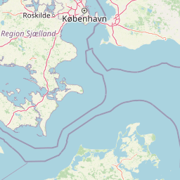
Map view of Bagholt Mose

Use this park location map to pinpoint Bagholt Mose in Denmark, understand its exact geographic position, and read its mapped placement within the surrounding landscape more clearly.

Pigeon | © OpenStreetMap contributors

Location context for Bagholt Mose

Faxe Municipality
Recorded earthquake history

Explore the Historical Earthquake Records and Seismic Data for Bagholt Mose

Examine the seismic history of Bagholt Mose through a detailed catalogue of recorded events. Review event data and epicentre proximity to understand the documented seismic context of this significant Danish nature reserve.

Bagholt Mose Earthquake History

Catalogued events

1 event

Strongest magnitude

Magnitude 3.5

Most recent event

May 20, 2026

This history includes earthquakes recorded inside the park or within 50 km of its borders

Park atlas

Compare regional wetland reserves and connected southern Zealand protected landscapes.

Explore Protected Areas and Other Parks Near Bagholt Mose

Continue geographic comparison by discovering other protected areas and wetland reserves located near Bagholt Mose. Analyzing surrounding regional park geography provides deeper context into the diverse natural landscapes of southern Zealand.
Nature reserveSolrød Kommune
About 19 km away#1 closest

Northeast

Staunings Ø Nature Reserve: Exploring the Coastal Geomorphology of Solrød Kommune

A mapped barrier spit and wetland habitat on the eastern Zealand shoreline.

Staunings Ø functions as a textbook example of a coastal sand bar accretion in the shallow waters of Køge Bugt. This nature reserve protects a vital sequence of dunes, lagoons, and reedbeds that provide a clear view of coastal succession. Located near the urban edge of Solrød Kommune, it serves as a key site for understanding the interaction between natural coastal landforms and maritime environments in eastern Denmark.

Area
0.6 km²
Established
1999
Relief
Lowland
Climate
Temperate
Wildlife reserveDenmark
About 32 km away#2 closest

Southwest

Dybsø Fjord Wildlife Reserve: Coastal Geography and Protected Wetland Map in Denmark

A shallow fjord system on the southwestern coast of Zealand

Dybsø Fjord represents a primary protected landscape in Denmark, featuring a broad and exceptionally shallow lagoon environment. By tracing its boundaries and surrounding peninsulas, users can analyze a critical wetland habitat that supports international bird protection networks and reflects the unique coastal scenery of the Baltic region.

Area
17 km²
Established
1940
Relief
Lowland
Scope
Mixed
A horizontal watercolor painting showing a soft green shoreline in the foreground and rolling hills across the water in the distance.
Nature reserveNaestved Municipality
About 33 km away#3 closest

Southwest

Dybsø Nature Reserve: Protected Coastal Landscape in Naestved Municipality

Geographic atlas of a protected Danish barrier island

Dybsø is a distinct barrier island situated off the coast of Zealand. Its protected landscape consists of open grasslands, coastal reed beds, and freshwater ponds that shelter the shallow waters of the fjord system. As a designated nature reserve, the area represents a critical wildlife refuge, maintained through traditional grazing to preserve its unique maritime terrain and geological history.

Area
1.34 km²
Established
1978
Relief
Lowland
Climate
Temperate
A horizontal watercolor painting depicting a soft, light-filled meadow landscape with scattered trees, low vegetation, and patches of water.
Nature reserveCopenhagen
About 46 km away#4 closest

Northeast

Amager Fælled Nature Reserve: Mapping Copenhagen's Distinctive Protected Landscape

Explore pioneer plant habitats and coastal meadow geography

Amager Fælled functions as a 223-hectare nature reserve that borders the urban development of Copenhagen. The landscape offers a study in contrasts, featuring thin drought-prone soils, historical military and landfill substrates, and protected coastal meadow strips. This site remains a vital geographical reference for understanding urban-edge conservation and the long-term layering of human land use.

Area
2.23 km²
Established
1992
Relief
Lowland
Climate
Temperate
Nature reserveDenmark
About 49 km away#5 closest

West

Stigsnæs-Borreby-Basnæs Nor Nature Reserve: Mapped Geography and Coastal Landscape Context

Protected wetlands and migration corridors in southern Denmark

Stigsnæs-Borreby-Basnæs Nor encompasses a complex interplay of manor-influenced farmland, reed-fringed shallows, and essential marshlands. This nature reserve functions as a critical funnel for migratory raptors and waterfowl on the southwestern edge of the Zealand coast. The area integrates deep cultural history with internationally recognized habitats, offering a clear window into the coastal terrain and wetland structure of the region.

Area
12.15 km²
Established
1978
Relief
Lowland
Scope
Mixed
A pale watercolor painting depicting a marshy landscape with rolling green hills, tall grasses in the foreground, and a calm body of water, rendered in soft pastel tones.
Protected areaDenmark
About 49 km away#6 closest

Northeast

Smør- og Fedtmosen: Glacial Tunnel Valley and Protected Mire Geography in Denmark

A key hydrological watershed site and managed meadow reserve

Examine the topographic features of Smør- og Fedtmosen, where groundwater-fed mires and dead-ice depressions create a distinct wetland system. This protected area showcases a transition from saturated reed beds to grazed meadows, illustrating the intersection of long-term conservation and the natural geography of a former tunnel valley.

Area
1.5 km²
Established
1943
Relief
Lowland
Scope
Terrestrial
A watercolor illustration of a soft rolling landscape with green forests, gentle hills in shades of yellow and pink, and a winding waterway.
Protected landscapeDenmark
About 50 km away#7 closest

North

Naturpark Mølleåen: A Protected Glacial Landscape and Tunnel Valley Map in Denmark

Glacial landforms and conserved nature corridors near Copenhagen

Naturpark Mølleåen spans fifty square kilometers of protected forests, lake districts, and ice-margin ridges in northern Zealand. This glacial terrain represents a nationally recognized geological area, offering a rare density of tunnel valleys and meltwater channels that serve as an essential ecological refuge within the broader Danish landscape.

Area
50 km²
Established
1942
Relief
Upland
Climate
Temperate
Nature reserveGentofte Kommune
About 52 km away#8 closest

Northeast

Brobæk Mose Nature Reserve: Protected Wetland and Glacial Geography in Gentofte Kommune

Mapped wetland habitat and natural terrain analysis.

Brobæk Mose serves as a primary example of a spring-fed wetland within the glacial landscapes of Gentofte Kommune. The area preserves rich fens and developing natural forest, offering a clear view of post-glacial valley geography and protected ecological zones surrounded by the Copenhagen suburban environment.

Established
1988
Water
Major water bodies

Common questions about visiting, size, designation, and location context for Bagholt Mose

Bagholt Mose FAQs for park facts, access, geography, and protected area context

Find quick answers about Bagholt Mose, including protected-area facts, park geography, trail and visitor context, and how the park fits into its surrounding country and regional landscape.
MoriAtlas Explorer

Continue Your Protected Areas Search Across the Global Atlas

Deepen your exploration by continuing the structured search for national parks and protected areas worldwide. Utilize the comprehensive filtering capabilities to compare different conservation landscapes and refine your understanding of global park geography. Discover more about the distribution and characteristics of protected natural areas.

Global natural geography