Mori Atlas logo
Nature reserveBrobæk Mose

A rare urban-edge wetland habitat featuring spring-fed fens, natural forest, and historic water sources.

Brobæk Mose Nature Reserve: Mapped Protected Landscapes and Glacial Valley Geography in Gentofte Kommune

Brobæk Mose sits within a glacial meltwater valley near Gentofte Kommune, preserving a mosaic of open bog pools, scrubby thickets, and deciduous woodland. This protected nature reserve provides a critical ecological window into the region, showcasing spring-fed water quality and rich fen habitats on the edge of the Copenhagen metropolitan area. The area illustrates how post-glacial geological formations continue to shape local terrain and conservation priorities.

wetlandbogspring mirerich fennatural forestdeciduous woodland

Brobæk Mose

Nature reserve

Park overview

Structured park overview, official facts, and landscape profile for Brobæk Mose

Brobæk Mose park facts, protected area profile, and essential visitor context

Review the core facts for Brobæk Mose, including designation, size, terrain, visitor scale, habitats, and operating context in one park-focused overview.

About Brobæk Mose

Brobæk Mose is a small but ecologically distinctive wetland on the northern outskirts of the Copenhagen urban area, in the municipality of Gentofte. It forms part of a wider natural complex centered on Gentofte Sø, with which it shares a common geological origin as a meltwater valley carved at the end of the last Ice Age. Today the bog presents a layered landscape: open water-filled hollows at its center, scrubby thickets surrounding them, and a stretch of deciduous forest in the north where Brobækken, the small stream that gives the area its name, flows toward the lake.

The wetland's ecological importance comes largely from its combination of spring mires, rich fens, and naturally developing woodland. Spring water in the area emerges clean, and only takes on a rusty appearance as iron compounds oxidize on contact with the air in the streambed. Several named springs, including Helligkilden and Vangede kilde, are part of this hydrological picture, and the protected area is managed with the explicit goal of maintaining a near-natural bog and forest landscape without active forestry intervention.

Beyond its natural values, Brobæk Mose has an unusual cultural footprint. Its water quality made it part of Copenhagen's drinking-water supply for more than two centuries, and in the twentieth century the bog was owned by Nordisk Insulinlaboratorium, which used a portion of the area for recreation by diabetes patients. This pharmaceutical ownership has survived in local memory through the affectionate nickname 'Insulinmosen', even though the area today simply belongs to Gentofte Kommune.

As part of Natura 2000 area number 141, the bog has cross-border ecological recognition, and ongoing management focuses on controlling invasive plants, keeping the rich fen communities open, and allowing the existing deciduous stands to evolve toward a more natural forest state.

Quick facts and research context for Brobæk Mose

Brobæk Mose is a small protected wetland in Gentofte Kommune, north of Copenhagen, Denmark, forming a Natura 2000 habitat area together with the adjacent Gentofte Sø. The area lies in a glacial meltwater valley from the end of the last Ice Age, around 11,000 years ago, and combines open bog, scrub, and deciduous woodland. A northern section has been under formal nature protection since 1988, and the site is recognized for its clean spring water, peatland history, and rich fen and spring mire habitats.

Protection and recognition

Documented conservation status, official designation timeline, and recognition records for Brobæk Mose

Brobæk Mose Protection Status and 1988 Protected Area Designation History

Brobæk Mose preserves documented protection status and designation history stemming from its established 1988 establishment year. Structured conservation records provide clear insight into the official governance and protected area timeline associated with the landscape.

Protection details

Designated year
1988
Park context

Deeper park guide and search-rich context for Brobæk Mose

Brobæk Mose history, landscape, wildlife, and travel context

Explore Brobæk Mose through its history, landscape character, ecosystems, wildlife, conservation priorities, cultural context, and seasonal travel timing in a structured park guide built for atlas discovery and search intent.

Why Brobæk Mose stands out

Brobæk Mose is best known for its spring-fed wetland character, including the historic Helligkilden and Vangede kilde springs whose water appears reddish due to natural iron compounds oxidizing in the stream. It is also recognized for its rich fens (rigkær), spring mires, and the developing natural forest in the area's northern section. The unusual drinking-water history of the wetland and its past ownership by Nordisk Insulinlaboratorium add a distinctive cultural layer to its ecological profile.
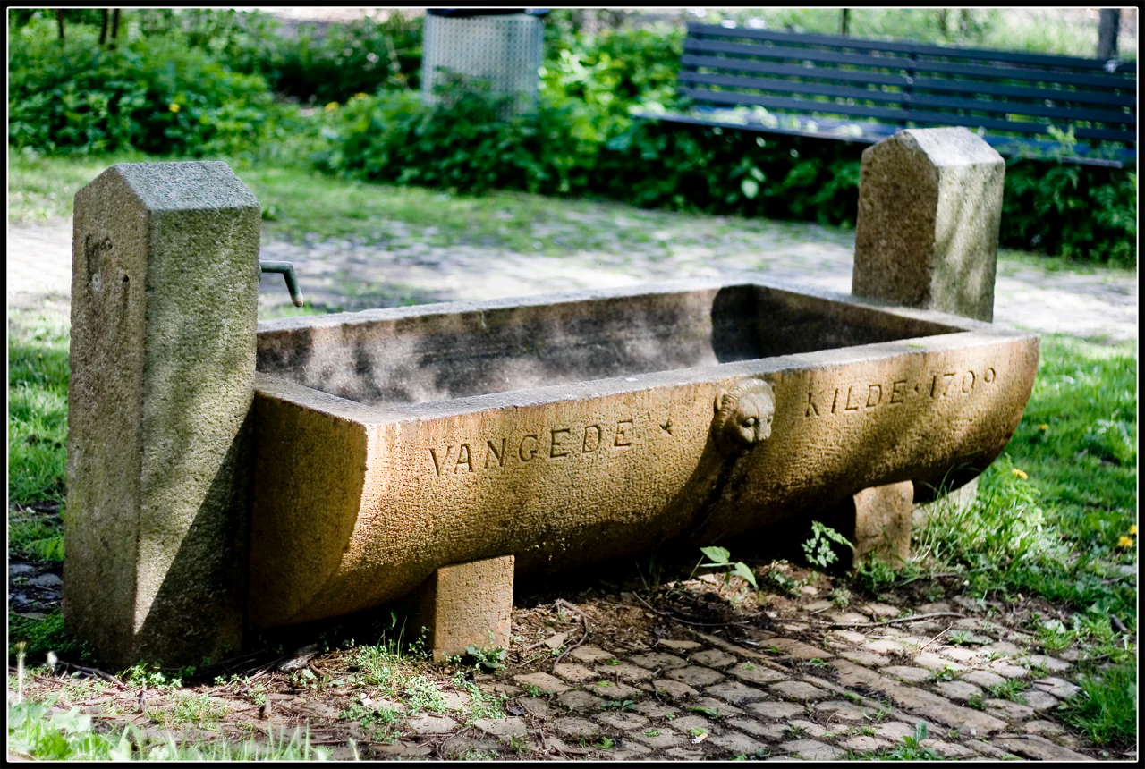
A historic stone water trough or spring fountain with the text Vangede Kilde 1709 carved into the side, situated on a stone paved path with a park bench in the background.
The historic Vangede Kilde fountain, dating back to 1709, located in Brobæk Mose.

Brobæk Mose history and protected-area timeline

The physical history of Brobæk Mose begins with the withdrawal of the last Ice Age ice, roughly 11,000 years ago, when meltwater carved the valley in which both the bog and Gentofte Sø now lie. Over the following millennia, natural changes in water level, combined with peat cutting and various planting efforts, shaped the mosaic of open bog, scrub, and woodland seen today. The forest in the northern section has now been left undisturbed for around fifty years.

In human terms, the water from Brobæk Mose and the nearby lake was considered clean enough to be used as drinking water for Copenhagen from 1717 until 1959, a span of more than two centuries. After the land reforms associated with the enclosure movement reached the area in 1776, the bog came under the ownership of Brobæk Gård.

In the twentieth century the wetland passed to Nordisk Insulinlaboratorium, the Danish pharmaceutical company that produced insulin. The company used part of the bog as a recreational area for diabetes patients, embedding the site in the history of early diabetes care in Denmark and giving the place the popular name 'Insulinmosen'. Nordisk Insulinlaboratorium sold the area in 1983, after which ownership passed to Gentofte Kommune.

The northern part of the bog, covering around 12.4 hectares, was formally placed under nature protection in 1988. Its inclusion in the Natura 2000 network as part of habitat area 141, Brobæk Mose og Gentofte Sø, cemented its role as a formally recognized European conservation site as well as a local one.

Brobæk Mose landscape and geographic character

Brobæk Mose lies in a glacial meltwater valley formed at the end of the last Ice Age, about 11,000 years ago. This geological inheritance determines much of the area's present-day appearance, since the valley's gentle basin retains water and supports the wetland conditions that define the bog. The same valley continues southward and eastward into Gentofte Sø.

The bog displays a clear zonation between open bog hollows in its central parts, scrubby thickets around those hollows, and a stretch of deciduous forest at the northern end. Brobækken, the small stream named in the bog's title, runs through this northern section. The water appears rusty or ochre-colored in the stream, but this is purely an iron-based coloration from natural compounds in the spring water oxidizing on contact with air; the water itself is very clean.

The broader setting is highly urbanized. Brobæk Mose is surrounded by the built-up northern suburbs of Copenhagen, and visible geological and ecological contrasts between the urban surroundings and the natural valley floor are part of the area's character. Although small, the landscape features a surprising concentration of named springs, including Helligkilden and Vangede kilde.

Brobæk Mose ecosystems, habitats, and plant life

Ecologically, Brobæk Mose is recognized for its spring mires, rich fens, and patchy woodland on peat and mineral soils. Spring water rising through the system is unusually clean, and it has shaped both the chemistry and the vegetation of the area. Where springs emerge, small mires (kildevæld) and rich fen communities (rigkær) have historically developed, though many of the spring sites are now overgrown and largely hidden within the developing forest.

The northernmost section of the bog has been allowed to develop into forest without forestry intervention, and stands are now broadly classified as natural forest (naturskov). This makes the area valuable as a reference site for understanding how a near-natural forest can establish itself on former wetland land in a Danish setting.

At the open center of the bog, common reed (tagrør) historically dominated, and continues to do so where reeds are still harvested for management. Surrounding the central feature known locally as 'blomsterengen' (the flower meadow), a ring of rich fen vegetation is considered one of the area's most important habitats. Management efforts aim to keep this ring open by removing reed encroachment and suppressing aggressive tall herbs.

Habitat variety within this small area, including open water in bog pools, peat substrate, mineral-rich spring outflows, and developing deciduous forest, is a major reason the bog and Gentofte Sø together qualify as a Natura 2000 habitat area.

Brobæk Mose wildlife and species highlights

The wildlife interest of Brobæk Mose is closely linked to its small-scale variety of habitats: bog pools, reeds, rich fens, spring mires, and deciduous woodland. Wetland birdlife associated with reedbeds, open water, and transition zones between bog and forest is a natural feature of the area, while invertebrates tied to calcareous seepage and rich fen vegetation form an important, though less visible, component of its ecological value.

The forest section, which has been undisturbed for several decades, supports woodland species typical of naturally regenerating Danish deciduous cover. The presence of mature trees alongside younger growth, deadwood, and wet microsites creates conditions for a range of woodland invertebrates, fungi, and breeding birds.

Specific fauna inventories are not extensively documented in the available source, but management plans highlight that the area's continued ecological function depends heavily on maintaining open rich fen vegetation for the species that depend on it, particularly in the ring of rigkær around the central flower meadow.

Brobæk Mose conservation status and protection priorities

Brobæk Mose is protected at multiple levels. A 12.4-hectare northern section has been formally protected under Danish nature conservation law since 1988, and the broader Brobæk Mose and Gentofte Sø complex has been designated as habitat area number 141 within the European Natura 2000 network. These designations recognize the area as a regionally and internationally important site for spring mires, rich fens, and naturally regenerating deciduous forest.

The overarching conservation goal is to preserve the existing natural forest and bog character with minimal interference. This includes allowing natural forest dynamics to continue in the northern woodland and protecting the hydrology of springs and fens, which are highly sensitive to changes in water quality and flow.

Active management is focused on a few targeted interventions. Reed is regularly harvested in parts of the bog, and efforts are being intensified around the central rich-fen ring surrounding the 'blomsterengen' to remove reed encroachment and counteract woody and tall-herb succession. The most significant threat identified by managers is overgrowth of spring mires and rich fens by trees, shrubs, and tall herbs, which would gradually eliminate the open vegetation those habitats depend on.

A second priority is invasive species. Surveys have recorded several invasive plants in the bog, including giant hogweed (kæmpe bjørneklo), Japanese knotweed (japanpileurt), and late goldenrod (sildig gyldenris). These are tracked as a long-term threat to multiple habitat types and species, and ongoing control is part of the conservation approach.

Brobæk Mose cultural meaning and human context

The cultural layer of Brobæk Mose reflects both its long utility as a source of clean water and its more recent role in Danish medical history. From 1717 to 1959, water from the bog and adjacent lake was used as part of Copenhagen's drinking-water supply, embedding the wetland in the everyday infrastructure of the capital for more than two centuries.

After the Danish enclosure changes of 1776, the bog fell under the farm Brobæk Gård, leaving a lasting imprint in the local toponymy. In the twentieth century, ownership passed to Nordisk Insulinlaboratorium, a pioneering Danish insulin producer, which used part of the mose as recreation space for patients with diabetes. This pharmaceutical chapter survives in local memory through the soft, informal name 'Insulinmosen', which remains a recognizable alternative reference for the site today, even though Nordisk Insulinlaboratorium sold the land in 1983 and it is now owned by Gentofte Kommune.

The cultural landscape around Brobæk Mose also includes named springs such as Helligkilden, which carry their own small traditions of folklore and local memory. One of the spring stones in the bog is dated to 1709, hinting at older practices of marking and venerating these water sources.

Top sights and standout views in Brobæk Mose

A compact wetland with rare spring-fed water quality and a striking heritage: drinking water for Copenhagen from 1717 to 1959, a Natura 2000 designation together with Gentofte Sø, and the unusual twentieth-century chapter as 'Insulinmosen' under Nordisk Insulinlaboratorium. Ecologically, the area stands out for its combination of clean spring outflows, rich fens, developing natural forest, and named springs such as Helligkilden and Vangede kilde, all pressed up against the urban edge of northern Copenhagen.

Best time to visit Brobæk Mose

Brobæk Mose can be appreciated year-round, but late spring and early summer are typically the best periods to experience the open rich-fen communities and the central 'blomsterengen', when the flowers and rich fen vegetation around the bog's open areas are most visible and reed management is actively under way. Autumn offers a quieter atmosphere with the deciduous stands in the northern section putting on seasonal color, and the call of waterfowl over the bogs and adjacent lake is more noticeable in the cooler months. Winter visits can also be rewarding for observing the wetland's hydrology clearly, with fewer leaves on the trees making brooks and spring areas easier to see.
Monthly climate preview

Long-term temperature ranges and monthly precipitation patterns sampled across representative coordinates

Brobæk Mose Climate Normals, Average Temperatures, and Monthly Precipitation

Brobæk Mose records long-term monthly temperature averages ranging from near freezing to warm summer highs alongside consistent precipitation rates. Examining the full twelve-month climate profile reveals complete seasonal temperature swings and multi-year precipitation normals.
Annual mean9 °C
1 °C18 °C
Jan
Feb
Mar
Apr
May11°
Jun15°
Jul18°
Aug17°
Sep14°
Oct
Nov
Dec
Warmest month
July

17.5 °C

Coolest month
February

0.6 °C

Wettest month
August

2.6 mm/day

Driest month
April

1.4 mm/day

Park location guide

Geography guide, regional context, and park location map for Brobæk Mose

Brobæk Mose park geography, regions, and map view in Denmark

Understand where Brobæk Mose sits in Denmark through a broader geographic reading of the surrounding landscape, nearby location context, and its mapped position within the national park landscape.

How Brobæk Mose fits into Denmark

Denmark is a constitutional monarchy and Nordic country in Northern Europe. It is the southernmost of the Scandinavian countries, bordering Germany to the south, Norway to the north, and Sweden to the southwest. The country consists of the Jutland peninsula and an archipelago of islands, with Copenhagen as its capital and largest city. Denmark has a population of over 6 million and is characterized by flat, arable land, sandy coasts, and a temperate climate.

Wider geography shaping Brobæk Mose in Denmark

Denmark occupies the Jutland peninsula and roughly 406 islands in Northern Europe. It is situated between the North Sea to the west and the Baltic Sea to the east. The country borders Germany to the south and is connected to Sweden via the Øresund Bridge. Denmark is predominantly flat terrain with low elevation, the highest point being Møllehøj at 170.86 meters.

Map view of Brobæk Mose

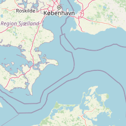
Use this park location map to pinpoint Brobæk Mose in Denmark, understand its exact geographic position, and read its mapped placement within the surrounding landscape more clearly.

Pigeon | © OpenStreetMap contributors

Location context for Brobæk Mose

Gentofte Kommune

Explore photographic records of spring-fed bogs, rich fens, and deciduous woodland habitats.

Brobæk Mose Photos and Landscape Scenery: Visualizing Protected Wetland Terrain

Visual records reveal the complex glacial meltwater valley terrain, open bog pools, and dense thickets defining the protected wetland environment. Photographic documentation provides clear insight into the ecological character, spring formations, and urban-edge natural habitats preserved across the reserve.

A historic stone water trough or spring fountain with the text Vangede Kilde 1709 carved into the side, situated on a stone paved path with a park bench in the background.

Park atlas

Compare adjacent wetland habitats, glacial valleys, and regional reserves

Explore Other Parks Near Brobæk Mose and Surrounding Protected Landscapes

Browsing other parks near Brobæk Mose allows visitors to examine similar glacial meltwater valleys and urban wetland ecosystems across the wider region. Comparing these connected protected landscapes reveals broader patterns in regional park geography and spring-fed natural habitats.
A pale watercolor painting depicting a marshy landscape with rolling green hills, tall grasses in the foreground, and a calm body of water, rendered in soft pastel tones.
Protected areaDenmark
About 5.7 km away#1 closest

West

Smør- og Fedtmosen: Glacial Tunnel Valley and Protected Mire Geography in Denmark

A key hydrological watershed site and managed meadow reserve

Examine the topographic features of Smør- og Fedtmosen, where groundwater-fed mires and dead-ice depressions create a distinct wetland system. This protected area showcases a transition from saturated reed beds to grazed meadows, illustrating the intersection of long-term conservation and the natural geography of a former tunnel valley.

Area
1.5 km²
Established
1943
Relief
Lowland
Scope
Terrestrial
A watercolor illustration of a serene lakeside landscape with green hills, foliage, and calm water, painted in soft pastel colors.
Protected areaNorth Zealand
About 8.9 km away#2 closest

Northwest

Furesø Protected Area: Mapping the Deepest Glacial Lake and Wetland Systems of North Zealand

Glacial tunnel valley landscapes and Natura 2000 protected waters.

Spanning deep basins and shallow shorelines, Furesø represents a significant protected freshwater body within the North Zealand region. The surrounding mosaic of peatlands and alder swamps highlights a legacy of glacial activity and ongoing conservation efforts. This area remains a focal point for understanding the interplay between metropolitan geography and preserved natural terrain.

Area
9.41 km²
Relief
Lowland
Climate
Temperate
Access
Easy access
A horizontal watercolor painting depicting a soft, light-filled meadow landscape with scattered trees, low vegetation, and patches of water.
Nature reserveCopenhagen
About 12 km away#3 closest

South

Amager Fælled Nature Reserve: Mapping Copenhagen's Distinctive Protected Landscape

Explore pioneer plant habitats and coastal meadow geography

Amager Fælled functions as a 223-hectare nature reserve that borders the urban development of Copenhagen. The landscape offers a study in contrasts, featuring thin drought-prone soils, historical military and landfill substrates, and protected coastal meadow strips. This site remains a vital geographical reference for understanding urban-edge conservation and the long-term layering of human land use.

Area
2.23 km²
Established
1992
Relief
Lowland
Climate
Temperate
A watercolor illustration of a soft rolling landscape with green forests, gentle hills in shades of yellow and pink, and a winding waterway.
Protected landscapeDenmark
About 20 km away#4 closest

West

Naturpark Mølleåen: A Protected Glacial Landscape and Tunnel Valley Map in Denmark

Glacial landforms and conserved nature corridors near Copenhagen

Naturpark Mølleåen spans fifty square kilometers of protected forests, lake districts, and ice-margin ridges in northern Zealand. This glacial terrain represents a nationally recognized geological area, offering a rare density of tunnel valleys and meltwater channels that serve as an essential ecological refuge within the broader Danish landscape.

Area
50 km²
Established
1942
Relief
Upland
Climate
Temperate
Nature reserveSolrød Kommune
About 33 km away#5 closest

Southwest

Staunings Ø Nature Reserve: Exploring the Coastal Geomorphology of Solrød Kommune

A mapped barrier spit and wetland habitat on the eastern Zealand shoreline.

Staunings Ø functions as a textbook example of a coastal sand bar accretion in the shallow waters of Køge Bugt. This nature reserve protects a vital sequence of dunes, lagoons, and reedbeds that provide a clear view of coastal succession. Located near the urban edge of Solrød Kommune, it serves as a key site for understanding the interaction between natural coastal landforms and maritime environments in eastern Denmark.

Area
0.6 km²
Established
1999
Relief
Lowland
Climate
Temperate
Watercolor illustration of green hills, a body of water, and vegetation
National parkDenmark
About 35 km away#6 closest

Northwest

Kongernes Nordsjælland National Park: Protected Landscape Geography and Map Context

Explore North Zealand's protected natural terrain.

Delve into the protected landscape of Kongernes Nordsjælland National Park, a significant national park in Denmark's North Zealand region. This section provides a structured overview of its mapped boundaries and geographic setting, allowing for a detailed atlas-style discovery of its natural terrain. Understand how this protected area contributes to the region's conservation landscape and mapped geography.

IUCN
II
National parkSweden
About 50 km away#7 closest

Northeast

Söderåsen National Park: A Protected Ridge Landscape in Southern Sweden's Geography

Mapped protected area with varied terrain and dense forest cover.

Delve into the protected landscape of Söderåsen National Park, a national park in Southern Sweden distinguished by its unique ridge topography, steep slopes, and extensive forests. This site serves as a key point for atlas-based exploration of natural terrain and regional geography, offering a clear view of its mapped boundaries and ecological significance within the Southern Swedish highlands. Understand the character of this protected area and its place in the broader mapped landscape.

Established
2001
IUCN
II
Scope
Terrestrial
Watercolor painting of green trees on rolling hills under a pink and orange sunset
National parkSweden
About 51 km away#8 closest

East

Dalby Söderskog National Park: Explore Southern Sweden's Smallest Protected Deciduous Forest

Unique limestone geology, spring flowers, and mapped terrain.

Dalby Söderskog National Park, though only 36 hectares, offers exceptional botanical discovery rooted in its fertile limestone soils. This protected area in Scania, Sweden, showcases a dense deciduous forest ecosystem with remarkable diversity, particularly evident in its vibrant spring wildflower displays. Use MoriAtlas to explore the park's mapped boundaries and understand its significant role within the regional geography and broader protected landscape atlas.

Area
0.36 km²
Established
1918
IUCN
II
Relief
Lowland

Common questions about visiting, size, designation, and location context for Brobæk Mose

Brobæk Mose FAQs for park facts, access, geography, and protected area context

Find quick answers about Brobæk Mose, including protected-area facts, park geography, trail and visitor context, and how the park fits into its surrounding country and regional landscape.
MoriAtlas Explorer

Continue Your Protected Areas Search Across the Global Atlas

Deepen your exploration by continuing the structured search for national parks and protected areas worldwide. Utilize the comprehensive filtering capabilities to compare different conservation landscapes and refine your understanding of global park geography. Discover more about the distribution and characteristics of protected natural areas.

Global natural geography