Mori Atlas logo
National parkSöderåsen National Park

Discover the mapped boundaries and natural terrain of this unique national park in Southern Sweden.

Söderåsen National Park: Explore Sweden's Protected Ridge Landscape and Geography

Söderåsen National Park represents a significant protected area in Southern Sweden, safeguarding a distinctive ridge landscape shaped by steep terrain and dense forests. Established to preserve this unique geological formation, the park offers an invaluable resource for understanding regional geography and protected land distribution. Explore its mapped boundaries and varied natural terrain to appreciate its ecological and recreational importance within the Southern Swedish highlands.

national parkSwedenprotected areanature reserveforest protectionhills and ridges

Söderåsen National Park

National park

Park overview

Structured park overview, official facts, and landscape profile for Söderåsen National Park

Söderåsen National Park park facts, protected area profile, and essential visitor context
Review the core facts for Söderåsen National Park, including designation, size, terrain, visitor scale, habitats, and operating context in one park-focused overview.

About Söderåsen National Park

Söderåsen National Park is a protected area located in southern Sweden. The park encompasses a distinctive ridge landscape characterized by steep terrain, dense forests, and varied topography. Established to preserve this unique hill formation in the southern Swedish highlands, the area represents an important ecological and recreational resource within the region.

Park location guide

Geography guide, regional context, and park location map for Söderåsen National Park

Söderåsen National Park park geography, regions, and map view in Sweden
Understand where Söderåsen National Park sits in Sweden through a broader geographic reading of the surrounding landscape, nearby location context, and its mapped position within the national park landscape.

How Söderåsen National Park fits into Sweden

Sweden, formally the Kingdom of Sweden, is a highly developed Nordic country on the Scandinavian Peninsula in Northern Europe. With a population of 10.6 million and an area of 450,295 km², it is the largest Nordic country by both area and population. Sweden is a constitutional monarchy with Stockholm as its capital and largest city, known for its advanced economy, social welfare system, and membership in the European Union and NATO.

Wider geography shaping Söderåsen National Park in Sweden

Sweden occupies the eastern portion of the Scandinavian Peninsula in Northern Europe. It borders Norway to the west and north, Finland to the east, and shares a maritime border with Denmark to the southwest across the Øresund. The country has an extensive coastline along the Baltic Sea and Gulf of Bothnia, dotted with thousands of islands. The terrain varies from mountainous regions in the northwest to low-lying coastal areas and inland lakes in the south and central parts.

Map view of Söderåsen National Park

Use this park location map to pinpoint Söderåsen National Park in Sweden, understand its exact geographic position, and read its mapped placement within the surrounding landscape more clearly.

Pigeon | © OpenStreetMap contributors

Location context for Söderåsen National Park

Skåne County
Park atlas

Trace the regional spread of conserved landscapes and compare park geography in southern Sweden.

Explore Other National Parks and Protected Areas Near Söderåsen National Park
After viewing Söderåsen National Park, browse an expanded list of national parks and protected areas across southern Sweden, tracing their mapped geography and unique conservation landscapes. Compare key features, terrain, and protected status to understand the broader regional context of these conserved natural spaces.
Watercolor painting of green trees on rolling hills under a pink and orange sunset
National park

Dalby Söderskog National Park: Explore Southern Sweden's Smallest Protected Deciduous Forest

Unique limestone geology, spring flowers, and mapped terrain.

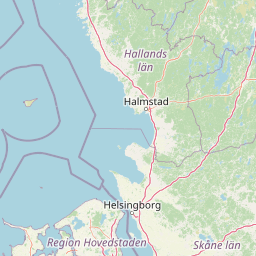
Dalby Söderskog National Park, though only 36 hectares, offers exceptional botanical discovery rooted in its fertile limestone soils. This protected area in Scania, Sweden, showcases a dense deciduous forest ecosystem with remarkable diversity, particularly evident in its vibrant spring wildflower displays. Use MoriAtlas to explore the park's mapped boundaries and understand its significant role within the regional geography and broader protected landscape atlas.

Area
0.36 km²
Established
1918
IUCN
II
Relief
Lowland
Watercolor illustration of green hills, a body of water, and vegetation
National park

Kongernes Nordsjælland National Park: Protected Landscape Geography and Map Context

Explore North Zealand's protected natural terrain.

Delve into the protected landscape of Kongernes Nordsjælland National Park, a significant national park in Denmark's North Zealand region. This section provides a structured overview of its mapped boundaries and geographic setting, allowing for a detailed atlas-style discovery of its natural terrain. Understand how this protected area contributes to the region's conservation landscape and mapped geography.

IUCN
II
Watercolor illustration of a landscape with green hills, water, and vegetation
National parkSkåne County

Stenshuvud National Park: Discover Skåne County's Distinctive Baltic Headland National Park

Explore broadleaf forests, heathlands, and panoramic coastal geography.

Stenshuvud National Park is a notable national park in Sweden's Skåne County, characterized by a prominent hill that rises 97 meters above the Baltic Sea. This protected landscape offers a rich diversity of habitats within a small area, including dense broadleaf forests, open heathlands, and coastal terrains. Its unique geographic position and varied ecosystems make it a key destination for exploring protected natural areas, mapped terrain, and regional landscape context within the MoriAtlas platform.

Area
3.9 km²
Established
1986
IUCN
II
Relief
Lowland
Watercolor painting of a landscape featuring mountains, wetland, and forest
National parkJönköping County

Store Mosse National Park: Explore Sweden's Largest Bog Landscape & Protected Area

Detailed park map, geography, and peatland ecosystem context.

Delve into Store Mosse National Park, a significant protected landscape in Jönköping County, Sweden, celebrated for its vast peat bog, the largest south of Lapland. This page provides detailed geographic context, mapping its unique wetland terrain, interspersed lakes like Kävsjön, and surrounding pine forests. Understand the park's ecological importance as a Ramsar site and its place within the South Småland peneplain for structured natural area discovery.

Area
78.5 km²
Established
1982
IUCN
II
Relief
Lowland
Watercolor illustration showing rolling hills, a lake, pink flowering trees, and distant mountains
National park

Mols Bjerge National Park: Protected Landscape and Geographic Atlas

Explore Denmark's second national park, a mosaic of glacial terrain and coast.

Mols Bjerge National Park offers a unique exploration of Denmark's glacial past through its mapped protected landscape. This 180 square kilometre national park on the Djursland peninsula is characterized by the prominent Mols Hills, rising to 137 metres, and diverse coastal environments along the Kattegat. The park preserves a rich mosaic of heath, woodlands, pastures, bogs, meadows, and coastal habitats, alongside significant prehistoric human heritage. Understanding Mols Bjerge National Park's protected boundaries and its place within the regional geography is key to appreciating its atlas value.

Area
180 km²
Established
2009
IUCN
II
Relief
Upland
Watercolor painting showing chalk cliffs along a coastline with calm water and distant hills
National parkMecklenburg-Vorpommern

Jasmund National Park: Germany's Coastal Chalk Cliffs and Primeval Forest Landscape

Explore the protected geography of Mecklenburg-Vorpommern's Rügen island.

Jasmund National Park showcases one of Northern Europe's most dramatic natural formations, defined by its striking white chalk cliffs plunging into the Baltic Sea and its UNESCO-recognized primeval beech forests. This protected area offers a profound look into geological heritage and undisturbed forest ecosystems. Navigate its mapped boundaries and understand its unique landscape context within the Mecklenburg-Vorpommern region through detailed atlas exploration on MoriAtlas.

Area
30 km²
Established
1990
IUCN
II
Visitors
300K annual
Watercolor illustration showing a coastal lagoon with sandy shoreline, calm water, sand dunes, and sparse vegetation including trees and grasses
National parkMecklenburg-Vorpommern

Western Pomerania Lagoon Area National Park: Detailed Geographic and Protected Landscape Context

Explore its mapped boundaries and unique Baltic Sea coastal geography.

Western Pomerania Lagoon Area National Park is a vital protected landscape in Mecklenburg-Vorpommern, renowned for its complex network of peninsulas, islands, and extremely shallow brackish 'bodden' waters. This page serves as an atlas entry, detailing the park's geographic features, its distinctive wind-driven water level fluctuations, and its ecological importance as a major migratory bird staging area. Users can investigate the mapped extent of this significant German national park and understand its unique place within the regional geography.

Area
805 km²
Established
1990
IUCN
II
Relief
Lowland
Watercolor illustration of a lake surrounded by trees and hills
National parkKalmar County

Norra Kvill National Park: Ancient Coniferous Forest Protected Landscape in Kalmar County

Discover its unique mapped terrain and natural forest heritage.

Norra Kvill National Park safeguards a remarkable old-growth coniferous forest ecosystem, a rarity in southern Sweden. This park is characterized by ancient pines, some dating back over 350 years, thriving on steep fault-formed terrain and amid boulder fields. Its protected status ensures the preservation of this unique natural landscape, providing invaluable insight into forest ecology and regional geography within Kalmar County. MoriAtlas offers a structured approach to understanding its mapped boundaries and ecological significance.

Area
1.14 km²
Established
1927
IUCN
II
Relief
Highland

Common questions about visiting, size, designation, and location context for Söderåsen National Park

Söderåsen National Park FAQs for park facts, access, geography, and protected area context
Find quick answers about Söderåsen National Park, including protected-area facts, park geography, trail and visitor context, and how the park fits into its surrounding country and regional landscape.
MoriAtlas Explorer

Continue Your Protected Areas Search Across the Global Atlas

Deepen your exploration by continuing the structured search for national parks and protected areas worldwide. Utilize the comprehensive filtering capabilities to compare different conservation landscapes and refine your understanding of global park geography. Discover more about the distribution and characteristics of protected natural areas.

Global natural geography
Söderåsen National Park: Explore Sweden's Protected Ridge Landscape