
Mori Atlas logo
Protected landscapeNaturpark Mølleåen

Mapping the tunnel valley terrain, glacial lakes, and conserved natural corridors

Naturpark Mølleåen Protected Landscape and Glacial Geography in Northern Zealand, Denmark

(Naturparken mellem Farum og Slangerup)

Naturpark Mølleåen defines a continuous protected landscape in northern Zealand, Denmark, characterized by its intricate tunnel valley topography and glacial landforms. Shaped by the retreat of the Weichselian ice sheet, this region features an alternating series of narrow meltwater channels, moraine ridges, and clear glacial lakes. Beyond its natural terrain, the area integrates preserved historic villages and long-standing conservation corridors into a unified ecological and geological site.

ice age landscapetunnel valleyglacial landformsprotected forestNatura 2000 sitelake district
A digital illustration of a scenic valley landscape featuring mountains, pine trees, a meandering river, and a waterfall under a soft sun.

Naturpark Mølleåen

Protected landscape

Park overview

Structured park overview, official facts, and landscape profile for Naturpark Mølleåen

Naturpark Mølleåen park facts, protected area profile, and essential visitor context

Review the core facts for Naturpark Mølleåen, including designation, size, terrain, visitor scale, habitats, and operating context in one park-focused overview.

About Naturpark Mølleåen

Naturpark Mølleåen, certified under its current name in 2016, occupies a continuous stretch of countryside north of Copenhagen in North Zealand. It is built around the upper Mølleå valley, where the river, also known locally as Hestetangså between Bastrup Sø and Farum Sø, has carved through one of the clearest tunnel valley landscapes in eastern Denmark. Because most of this territory is continuously protected forest or nature reserve, the park reads as a single, intact natural landscape rather than a patchwork of small reserves.

The park's character is a mixture of glacial landforms and historic North Zealand village land. Open lake scenery around Buresø, Bastrup Sø and Farum Sø alternates with dense forest on the ridges and larger slopes, including Sperrestrup Skov, Uggeløse Skov, Slagslunde Skov, Krogenlund, Ganløse Eged, Ganløse Ore, Terkelskov, Farum Lillevang, Ryget Skov and parts of Nørreskoven. Streams such as Græse Å, Bundså, Damvad Å and Jørlunde Å tie the wider landscape into the Værebro Å system. Visible cultural elements, including medieval churches, surviving small farms at Ganløse Mørke and traces of historic watermills at Hestetang and Kratmøllen, complete the park's identity.

Although modest in Danish park terms, the park has unusually strong ecological profile. Its central corridor is an EU Habitat Area and bird protection area, and the surrounding forest, lake and valley system provides refuge for a wide range of species characteristic of the eastern Danish lake and forest landscape. As a recreational area, the park supports an unusually extensive trail network for the Copenhagen region, linking the historic villages that are surrounded by but not absorbed into the park's protected interior.

Quick facts and research context for Naturpark Mølleåen

Naturpark Mølleåen lies in North Zealand, Denmark, between Farum and Slangerup, and concentrates around the upper Mølleå valley. It is administered through cooperation between the municipalities of Allerød, Egedal, Frederikssund and Furesø (formerly Farum). The park was formally certified by the Danish Nature Parks national committee on 9 December 2016, although its planning concept dates back to 1942.

The park's surface area is around 50 square kilometers, and approximately 1,240 hectares, around 75% of that area, are protected as nature reserves or as protected forest. The central axis of the park, the upper Mølleå valley with Furesø and Frederiksdal Skov, is designated as Natura 2000 site number 139 and protects 15 Danish habitat types and five species.

Protection and recognition

Explore terrestrial protected area records, designation years, and management scope.

Naturpark Mølleåen Protection Status and Official Designation History

Naturpark Mølleåen holds documented terrestrial protection status established in the year 2016 for regional conservation oversight. Official protected area records compile designation history, management scope, and recognition data for geographical analysis.

Protection details

Protection scope
Terrestrial
Designated year
2016
Transboundary protection
No
Core area
12.4 km²
Park context

Deeper park guide and search-rich context for Naturpark Mølleåen

Naturpark Mølleåen history, landscape, wildlife, and travel context

Explore Naturpark Mølleåen through its history, landscape character, ecosystems, wildlife, conservation priorities, cultural context, and seasonal travel timing in a structured park guide built for atlas discovery and search intent.

Why Naturpark Mølleåen stands out

Naturpark Mølleåen is best known for its tunnel valley landscape, a network of elongated glacial valleys, lakes and ice-margin ridges, formed beneath and in front of the Weichselian ice sheet around 13,000 years ago. The park's visual identity is shaped by alternating steep valley sides, narrow meltwater channels and clear lakes such as Buresø, Bastrup Sø and Farum Sø. It is also known as the oldest nature park idea in Denmark, conceived during the 1940s as a way to bring nature close to Copenhagen residents and supported by figures including Prime Minister Thorvald Stauning and Nobel laureate Johannes V. Jensen. This long planning history, together with its large continuous protected area and Natura 2000 designation, gives the park a recognized national significance.
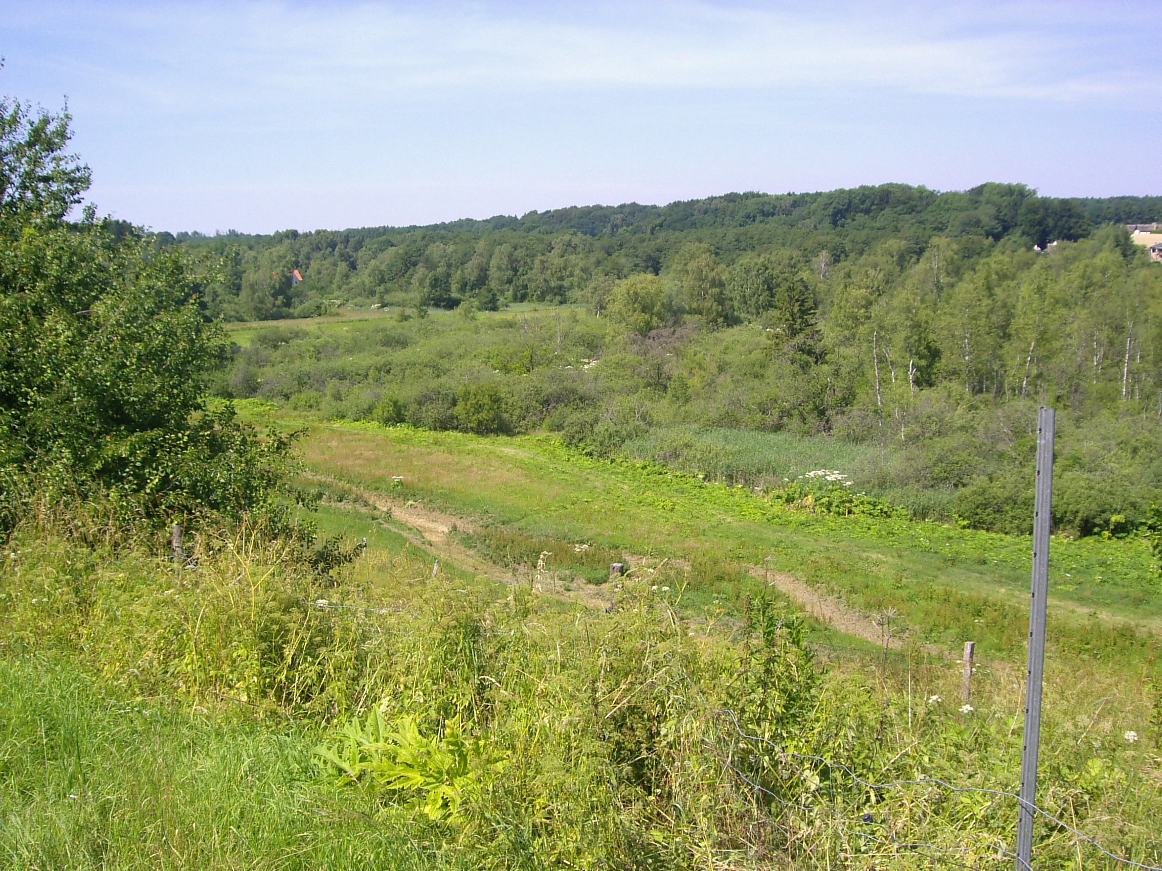
A wide view of a green valley with a dirt path winding through tall grasses and shrubs, surrounded by a dense forest under a clear sky.
View across the Mølleådalen valley in Naturpark Mølleåen, Denmark.

Naturpark Mølleåen history and protected-area timeline

The idea of a protected nature park north of Copenhagen was first articulated in March 1942 by cigar sorter Thorvald Vognsen, who held discussions with Prime Minister Thorvald Stauning and the Nobel Prize winning author Johannes V. Jensen. Vognsen had been inspired by his home region near Viborg, but the practical foundation came from the 1936 Greater Copenhagen Green Areas Report and the subsequent preservation and path plans of 1938 and 1940, both personally supported by Stauning. The København-Slangerup Banen railway, which began operating in 1906, had already promoted the region as a recreational destination.

The site selection was carried out by a scientific committee from the University of Copenhagen and Denmark's Lærerhøjskole, including state geologist Sigurd Hansen, who continued to be active in the area for two decades. The plans were presented publicly on 3 October 1942. After delays caused by Stauning's death, the Second World War and the post-war Finger Plan, conservation of the final major area in Staunings fredningsplan was not confirmed until 23 December 2010 by the Naturklagenævnet.

In 1967, Foreningen Naturparkens Venner was founded to continue the work of the original planning committee, with the aim of preserving and increasing awareness of the park. The 1965 book NATURPARKEN mellem Farum og Slangerup, edited by Carl Tscherning, became the standard reference for early public understanding of the area. The park's modern certification was completed on 9 December 2016, with the nature park plan adopted by the municipalities of Allerød, Egedal, Frederikssund and Furesø.

Naturpark Mølleåen landscape and geographic character

Naturpark Mølleåen is defined by a tunnel valley landscape, a glacial landform pattern in which long, narrow valleys, parallel ridges and isolated hills were eroded by pressurized water beneath the ice sheet and by later meltwater streams. The most recent glaciation retreated from the area roughly 13,000 years ago, and its erosional and depositional traces dominate the present topography.

The principal valley axis follows the upper Mølleå river corridor. From Klokkekildebakker, west of Ganløse and Slagslunde, to the lakes of Bastrup Sø and Farum Sø, the terrain alternates between steep valley sides, broad valley floors and elevated sandy ridges. Mølleådalen itself is interpreted by most researchers as an ancient meltwater channel that ran toward Slangerup at the end of the Ice Age. The lakes fill deeper sections of these glacial channels, while the surrounding forests grow on the higher, drier moraine and outwash surfaces.

Near Buresø, a small summerhouse area and the hamlet of Ryet mark the transition between protected interior and fringe land use, while Ganløse Mørke preserves a typical North Zealand small-farm landscape. Together, these landforms create a varied scenery that is rare in Denmark for both the density and continuity of its glacial features.

Naturpark Mølleåen ecosystems, habitats, and plant life

The park's ecological identity rests on a continuous mosaic of glacial forest, valley lakes and small streams, situated within a landscape that has been formally protected for the better part of a century. The high share of protected forest and protected nature has allowed ecosystems to maintain coherence and resist fragmentation despite the park's proximity to the Copenhagen metropolitan area. Many of the protected areas within the park date back to the earliest fredningsplaner of the 1940s, and this long continuity has shaped both the structure and species composition of the forests and lakes.

The lakes and surrounding water bodies, including Buresø, Bastrup Sø and Farum Sø, together with the streams feeding into them, create a habitat gradient that runs from open water through reed fringes into damp woodland and upslope dry forest. The valley of Farum Sø and the wetland area of Farum Sortemose is designated as a bird protection area, while the broader valley axis is recognized as a national geological interest area in addition to its Natura 2000 status. The protected area covers 15 Danish habitat types and five species, including forest types, lake habitats and mire communities typical of eastern Denmark.

Naturpark Mølleåen wildlife and species highlights

The protected landscape of Naturpark Mølleåen supports a wildlife profile typical of intact North Zealand forest and lake systems, with birdlife closely linked to the lakes, wetlands and surrounding deciduous and mixed forests. The Farum Sø and Farum Sortemose area functions as a designated bird protection area, recognizing its importance for waterbirds and wetland species in a region otherwise dominated by farmland and suburban land use.

Forest fauna benefits from the large blocks of protected forest such as Ganløse Eged, Ryget Skov and Farum Lillevang, where long uninterrupted forest age creates conditions for typical woodland birds and mammals of the Danish eastern forest belt. The streams and smaller watercourses add further habitat variety for amphibians and invertebrates adapted to clean, cool water. Although specific species lists are not part of the source material, the combination of Natura 2000 habitat and bird protection status indicates a high level of formal ecological importance for the wider Copenhagen region.

Naturpark Mølleåen conservation status and protection priorities

Naturpark Mølleåen is a landmark in Danish conservation planning. Approximately three quarters of its land area, roughly 1,240 hectares, is protected as nature reserve or protected forest, leaving only the area immediately along surrounding roads and a small summerhouse zone near Buresø outside the formal protection framework. As a result, the park functions as a single, unfragmented natural area embedded in an actively used cultural landscape.

The park's central axis was protected already in 1948 and was designated as an EU Habitat Area in 1995, today numbered as Natura 2000 area 139 Øvre Mølleådal, Furesø og Frederiksdal Skov. This site protects 15 Danish habitat types and five species. The valley of Farum Sø and the Farum Sortemose wetland are additionally designated as a bird protection area. The park as a whole is recognized as a national geological interest area, reflecting the value of its glacial landforms as a reference for Danish Quaternary geology.

Naturpark Mølleåen cultural meaning and human context

The park is closely tied to the traditional villages of North Zealand, including Farum, Vassingerød, Lynge-Uggeløse, Slangerup, Jørlunde, Ølstykke, Slagslunde, Ganløse, Kirke Værløse and Lille Værløse, most of which lie at the margin of the protected landscape but are functionally connected to it. This creates a cultural setting in which medieval villages, parish churches and traces of older watermill agriculture coexist with active small farming, as is visible at Ganløse Mørke, Ryet and around Buresø.

Cultural heritage within the park includes old timber roads in Ryget Skov and Ganløse Eged, numerous burial mounds including those at Farum Lillevang and Ryet, traces of medieval watermills at Hestetang and Kratmøllen, and important medieval monuments. These include Bastruptårnet, dated to around 1130 and recognized as Denmark's oldest secular stone ruin, Bure Voldsted, mentioned in 1274 in connection with Erik Klipping and the Hvide family, and Farumgård, first recorded in 1370. The Myrestenen, a 60-ton erratic block covering 16 square meters and the largest known boulder in northeast Zealand, sits within Ganløse Eged.

Top sights and standout views in Naturpark Mølleåen

Naturpark Mølleåen combines glacial scenery, large protected forests, a string of glacial lakes and a historic village fringe into one of Denmark's most continuous nature park landscapes. Its tunnel valley topography, exemplified at Klokkekildebakker and along the Mølleå valley toward Slangerup, gives the park a distinctive landform identity that supports both ecological and scenic value.

The park's long conservation history, reaching back to early 1940s planning and to a 1948 protection of its central axis, gives it a unique status among Danish nature parks. Combined with its Natura 2000 designation, its nationally recognized geological importance and the presence of cultural monuments such as the Bastruptårnet and the Myrestenen erratic, the park stands out as an area where nature, geology and North Zealand cultural heritage meet in a coherent, well documented landscape.

Best time to visit Naturpark Mølleåen

Naturpark Mølleåen produces a fairly typical North Zealand seasonal cycle, in which spring brings fresh leaf canopy and active waterfowl display around lakes such as Farum Sø and Bastrup Sø, summer offers the most straightforward walking conditions along the extensive trail network, and autumn reveals layered color across forests such as Ganløse Eged, Ryget Skov and Farum Lillevang. Winter, with its bare deciduous canopy, exposes the park's glacial landforms much more clearly, making the tunnel valley ridges and lake basins easier to read in the landscape.

Monthly climate preview

Measured monthly climate patterns and average temperature trends across the protected landscape

Naturpark Mølleåen Climate Normals, Long-Term Temperature and Precipitation Rhythm

Naturpark Mølleåen exhibits a measured annual rhythm ranging from sub-zero winter minimums to warm summer maximums alongside consistent multi-millimeter daily precipitation averages. Examining the complete twelve-month climate profile provides deeper analytical context for long-term temperature variations and monthly precipitation totals across the representative coordinate.
Annual mean9 °C
1 °C18 °C
Jan
Feb
Mar
Apr
May11°
Jun15°
Jul18°
Aug17°
Sep14°
Oct
Nov
Dec
Warmest month
July

17.5 °C

Coolest month
February

0.6 °C

Wettest month
August

2.6 mm/day

Driest month
April

1.4 mm/day

Park location guide

Geography guide, regional context, and park location map for Naturpark Mølleåen

Naturpark Mølleåen park geography, regions, and map view in Denmark

Understand where Naturpark Mølleåen sits in Denmark through a broader geographic reading of the surrounding landscape, nearby location context, and its mapped position within the national park landscape.

How Naturpark Mølleåen fits into Denmark

Denmark is a constitutional monarchy and Nordic country in Northern Europe. It is the southernmost of the Scandinavian countries, bordering Germany to the south, Norway to the north, and Sweden to the southwest. The country consists of the Jutland peninsula and an archipelago of islands, with Copenhagen as its capital and largest city. Denmark has a population of over 6 million and is characterized by flat, arable land, sandy coasts, and a temperate climate.

Wider geography shaping Naturpark Mølleåen in Denmark

Denmark occupies the Jutland peninsula and roughly 406 islands in Northern Europe. It is situated between the North Sea to the west and the Baltic Sea to the east. The country borders Germany to the south and is connected to Sweden via the Øresund Bridge. Denmark is predominantly flat terrain with low elevation, the highest point being Møllehøj at 170.86 meters.

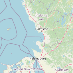
Map view of Naturpark Mølleåen

Use this park location map to pinpoint Naturpark Mølleåen in Denmark, understand its exact geographic position, and read its mapped placement within the surrounding landscape more clearly.

Pigeon | © OpenStreetMap contributors

Examine glacial valley terrain, protected forest habitats, and lake views across the protected area.

Naturpark Mølleåen Photos and Landscape Scenery Visual Exploration

Visual documentation reveals the tunnel valley terrain, steep glacial ridges, and clear lake waters that define the protected landscape. Examining these photographs helps observers understand the geological formations, forest habitats, and conservation character preserved within the region.

A wide view of a green valley with a dirt path winding through tall grasses and shrubs, surrounded by a dense forest under a clear sky.

Park atlas

Compare adjacent glacial valleys and connected nature reserves across northern Zealand.

Parks Near Naturpark Mølleåen: Explore Related Protected Landscapes and Regional Geography

Browse other parks near Naturpark Mølleåen to examine similar glacial valley networks, protected forests, and regional conservation corridors. Continuing across surrounding protected landscapes reveals broader geological patterns and connects individual reserves into a complete regional park network.
A watercolor illustration of a serene lakeside landscape with green hills, foliage, and calm water, painted in soft pastel colors.
Protected areaNorth Zealand
About 12 km away#1 closest

East

Furesø Protected Area: Mapping the Deepest Glacial Lake and Wetland Systems of North Zealand

Glacial tunnel valley landscapes and Natura 2000 protected waters.

Spanning deep basins and shallow shorelines, Furesø represents a significant protected freshwater body within the North Zealand region. The surrounding mosaic of peatlands and alder swamps highlights a legacy of glacial activity and ongoing conservation efforts. This area remains a focal point for understanding the interplay between metropolitan geography and preserved natural terrain.

Area
9.41 km²
Relief
Lowland
Climate
Temperate
Access
Easy access
A pale watercolor painting depicting a marshy landscape with rolling green hills, tall grasses in the foreground, and a calm body of water, rendered in soft pastel tones.
Protected areaDenmark
About 15 km away#2 closest

Southeast

Smør- og Fedtmosen: Glacial Tunnel Valley and Protected Mire Geography in Denmark

A key hydrological watershed site and managed meadow reserve

Examine the topographic features of Smør- og Fedtmosen, where groundwater-fed mires and dead-ice depressions create a distinct wetland system. This protected area showcases a transition from saturated reed beds to grazed meadows, illustrating the intersection of long-term conservation and the natural geography of a former tunnel valley.

Area
1.5 km²
Established
1943
Relief
Lowland
Scope
Terrestrial
Nature reserveGentofte Kommune
About 20 km away#3 closest

East

Brobæk Mose Nature Reserve: Protected Wetland and Glacial Geography in Gentofte Kommune

Mapped wetland habitat and natural terrain analysis.

Brobæk Mose serves as a primary example of a spring-fed wetland within the glacial landscapes of Gentofte Kommune. The area preserves rich fens and developing natural forest, offering a clear view of post-glacial valley geography and protected ecological zones surrounded by the Copenhagen suburban environment.

Established
1988
Water
Major water bodies
Watercolor illustration of green hills, a body of water, and vegetation
National parkDenmark
About 21 km away#4 closest

North

Kongernes Nordsjælland National Park: Protected Landscape Geography and Map Context

Explore North Zealand's protected natural terrain.

Delve into the protected landscape of Kongernes Nordsjælland National Park, a significant national park in Denmark's North Zealand region. This section provides a structured overview of its mapped boundaries and geographic setting, allowing for a detailed atlas-style discovery of its natural terrain. Understand how this protected area contributes to the region's conservation landscape and mapped geography.

IUCN
II
A horizontal watercolor painting depicting a soft, light-filled meadow landscape with scattered trees, low vegetation, and patches of water.
Nature reserveCopenhagen
About 29 km away#5 closest

Southeast

Amager Fælled Nature Reserve: Mapping Copenhagen's Distinctive Protected Landscape

Explore pioneer plant habitats and coastal meadow geography

Amager Fælled functions as a 223-hectare nature reserve that borders the urban development of Copenhagen. The landscape offers a study in contrasts, featuring thin drought-prone soils, historical military and landfill substrates, and protected coastal meadow strips. This site remains a vital geographical reference for understanding urban-edge conservation and the long-term layering of human land use.

Area
2.23 km²
Established
1992
Relief
Lowland
Climate
Temperate
Nature reserveSolrød Kommune
About 34 km away#6 closest

South

Staunings Ø Nature Reserve: Exploring the Coastal Geomorphology of Solrød Kommune

A mapped barrier spit and wetland habitat on the eastern Zealand shoreline.

Staunings Ø functions as a textbook example of a coastal sand bar accretion in the shallow waters of Køge Bugt. This nature reserve protects a vital sequence of dunes, lagoons, and reedbeds that provide a clear view of coastal succession. Located near the urban edge of Solrød Kommune, it serves as a key site for understanding the interaction between natural coastal landforms and maritime environments in eastern Denmark.

Area
0.6 km²
Established
1999
Relief
Lowland
Climate
Temperate
Nature reserveFaxe Municipality
About 50 km away#7 closest

South

Bagholt Mose: Protected Peatland Mosaic and Fen Geography in Faxe Municipality, Denmark

A high-value Natura 2000 protected wetland and bog habitat.

Bagholt Mose is a significant nature reserve situated within the Munkeskov forest of southern Zealand. The landscape features a distinct combination of historical peat cuttings and raised bog remnants, which together form a rare mosaic of nutrient-poor and calcareous fen communities that support an exceptional diversity of lowland bog flora.

Area
0.17 km²
Established
1985
Relief
Lowland
Scope
Terrestrial
Watercolor painting of the island of Nekselø showing green hills rising above a pale sea against a light sky.
Nature reserveKalundborg Kommune
About 59 km away#8 closest

West

Nekselø Nature Reserve: An Atlas Entry for the Unique Steppe-Climate Island in Denmark

Coastal geography and protected wetland terrain in Kalundborg Kommune

Nekselø represents a distinctive protected area in Denmark, where a unique microclimate creates favorable conditions for diverse, warmth-loving flora and fauna. As a managed nature reserve in Kalundborg Kommune, it offers a compelling study in island geography and small-scale, community-led conservation efforts within the international Ramsar and Natura 2000 protected frameworks.

Area
2.2 km²
Established
1951
Relief
Lowland
Scope
Mixed

Common questions about visiting, size, designation, and location context for Naturpark Mølleåen

Naturpark Mølleåen FAQs for park facts, access, geography, and protected area context

Find quick answers about Naturpark Mølleåen, including protected-area facts, park geography, trail and visitor context, and how the park fits into its surrounding country and regional landscape.
MoriAtlas Explorer

Continue Your Protected Areas Search Across the Global Atlas

Deepen your exploration by continuing the structured search for national parks and protected areas worldwide. Utilize the comprehensive filtering capabilities to compare different conservation landscapes and refine your understanding of global park geography. Discover more about the distribution and characteristics of protected natural areas.

Global natural geography