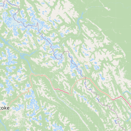
Peaks
Mount Mercer
2,970 m

A comprehensive analysis of mountain terrain, glacial systems, and regional geography
Banff National Park covers a vast mountainous region in Alberta, Canada, spanning over 6,641 square kilometers. This geographic record details the park's diverse terrain, including high-altitude peaks reaching 3,612 meters, expansive glacial systems like the Saskatchewan Glacier, and complex river and lake networks that define the landscape.
Related tags
Canada's first national park, a UNESCO World Heritage Site protecting iconic Rocky Mountain landscapes, glaciers, and diverse ecosystems
Banff National Park is Canada's first national park, established in 1885 as the Banff Hot Springs Reserve and later expanded through the Rocky Mountains Park Act of 1887. Located in Alberta's Rocky Mountains approximately 110-180 kilometres west of Calgary, the park encompasses 6,641 square kilometres of mountainous terrain featuring glaciers, ice fields, dense coniferous forests, and alpine landscapes. The park is part of the larger Canadian Rocky Mountain Parks World Heritage Site, recognized by UNESCO in 1984 for outstanding natural universal values including mountain peaks, glaciers, lakes, waterfalls, canyons, and fossil beds. The main commercial centre is the town of Banff in the Bow River valley, while the village of Lake Louise serves as another key access point. The park shares boundaries with Yoho National Park to the west, Kootenay National Park to the south, and Jasper National Park to the north, creating a contiguous protected corridor through the Canadian Rockies.
Regional placement and provincial boundaries within Canada
Mapping the 6,641 square kilometer land area and geographic footprint
Recorded mountain relief facts and internal natural water features
Peaks
2,970 m
Viewpoints
Peaks
3,210 m
Peaks
2,588 m
Peaks
2,940 m
Peaks
3,088 m
Subpolar relief, major watersheds, and diverse alpine habitats
Mountains · Valleys · Canyon · Forest · Wetland · Lakes · Rivers · Waterfalls · Glacier · Cave · Karst · Cliffs · Tundra
Alpine meadow · Boreal forest · Glacial habitat · Karst habitat · Lacustrine habitat · Riverine habitat · Wetland
Compare adjacent protected landscapes and trace the broader regional spread of conservation areas throughout the Canadian Rockies.
Northwest

Explore Alberta's regional park context and natural terrain.
Jasper National Park is a key protected national park in Alberta, Canada, offering extensive natural landscapes. This park page details its precise geographic location, outlines its protected boundaries, and provides context within the regional geography of Western Canada. Discover the mapped terrain and the park's significance as a protected area within a broader atlas perspective.
South
Explore Kootenay National Park's mapped terrain and regional geography.
Kootenay National Park is a protected national park located in British Columbia, Canada. This dedicated detail page provides an atlas-style exploration of its geographic identity, focusing on its mapped boundaries and the surrounding natural terrain. Understand how Kootenay National Park fits into the larger regional geography, offering rich context for protected landscape discovery and analysis.
West
Exploring the park's protected boundaries and terrain.
Yoho National Park is presented here as a distinct national park within British Columbia's vast geographic framework. This page provides a structured view of its protected land status, allowing for detailed exploration of its mapped boundaries and surrounding natural landscapes. Understand Yoho National Park's place in the Canadian atlas through its specific geographic features and protected area context.
West
Explore its mapped boundaries and regional geography.
Glacier National Park represents a significant protected area entity within the broader Canadian geography. This page offers an atlas-oriented perspective on its identity as a national park, focusing on its mapped geographic spread and role as a conservation landscape. Users can explore the park's place within the Columbia-Shuswap Regional District and understand its distinct contribution to the national protected area framework.
East
Protected riparian ecosystems along the Bow River in Alberta.
Analyze the geography of the Inglewood Migratory Bird Sanctuary, a federal wildlife reserve in Calgary, Alberta. This site preserves rare cottonwood floodplain forest and river habitats that serve as a critical stopover for migratory birds, offering a unique look at how protected landscapes persist within urban environments.
West
British Columbia's National Park Atlas Entry
Delve into the protected landscape of Mount Revelstoke National Park, a critical national park located in British Columbia. This entry provides a detailed look at its mapped geographic extent and protected area identity, offering valuable context for regional atlas exploration. Understand the park's distinct contribution to the mapped natural landscapes of Canada.
Northwest
Glacial cascades and North Thompson River valley terrain
This protected area centers on a vertical, two-stage waterfall spilling from a hanging valley high above the North Thompson River. Characterized by its glacier-fed creek and steep forested slopes, the park functions as a key geological landmark within the rugged, mountainous interior of British Columbia.
Northeast
Aspen Parkland terrain in central Alberta, Canada
The Red Deer Migratory Bird Sanctuary preserves a key wetland corridor defined by the Gaetz Lakes oxbows. This protected reserve offers a look at the native Aspen Parkland ecoregion, blending shrubland and forest patches that provide essential sanctuary for migratory waterfowl. The mapped area illustrates how this federal reserve maintains a natural landscape mosaic amidst the surrounding urban geography of central Alberta.
Delve deeper into the mapped geography and protected area specifics of Banff National Park. Understanding its unique landscape context within Canada offers valuable insights for regional geographic exploration and detailed atlas-based study. Continue your discovery of Banff National Park's natural terrain and its role as a protected national park.