
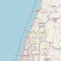
Discover the mapped boundaries and geographic context of Beit She'an National Park.
Beit She'an National Park stands as a key protected area, offering a distinct entry into Israel's rich geographic tapestry. This national park provides critical context for understanding the distribution of conservation lands and the mapped terrain of the region. As part of MoriAtlas, it serves as a focal point for exploring the specific landscape features and protected boundaries that define this important national park within the Middle East's atlas.
Beit She'an National Park
National park
Structured park overview, official facts, and landscape profile for Beit She'an National Park
Geography guide, regional context, and park location map for Beit She'an National Park
Israel is a parliamentary republic in the Southern Levant, established in 1948 as a Jewish homeland. It borders Lebanon, Syria, Jordan, and Egypt, with Mediterranean coastline and access to the Red Sea. Jerusalem is the capital, though its status is contested, while Tel Aviv is the largest urban area. The country has a high-income economy with strong technology and innovation sectors.
Israel occupies the Southern Levant region of West Asia. It is bordered by Lebanon to the north, Syria to the northeast, Jordan to the east, and Egypt to the southwest. The western coast lies on the Mediterranean Sea, while the southern tip reaches the Red Sea. The eastern border includes the Dead Sea, Earth's lowest point. The country occupies the West Bank, Gaza Strip, and Golan Heights.
Common questions about visiting, size, designation, and location context for Beit She'an National Park
Deepen your exploration by continuing the structured search for national parks and protected areas worldwide. Utilize the comprehensive filtering capabilities to compare different conservation landscapes and refine your understanding of global park geography. Discover more about the distribution and characteristics of protected natural areas.


