
Mori Atlas logo
Nature reserveBennhäuser Teich und Rothbalzer Teich bei Immenhausen

Examining the ecological landscape, historic pond hydrology, and woodland corridors of Northern Hessen.

Bennhäuser Teich und Rothbalzer Teich bei Immenhausen: Protected Nature Reserve and Wetland Geography

(Naturschutzgebiet Bennhäuser Teich und Rothbalzer Teich bei Immenhausen)

Bennhäuser Teich und Rothbalzer Teich bei Immenhausen encompasses a mosaic of near-natural woodland, sixteenth-century fish ponds, and spring-fed brook systems within the broader Reinhardswald landscape of central Germany. This protected nature reserve provides essential habitat for specialized wetland species while functioning as a focal point for regional hydrology. The site maps a distinct transition between dense forest slopes and lowland swamp environments, offering insights into long-term habitat development and conservation in Hessen.

nature reservepondforestwetlandswamp woodlanddragonfly habitat
A flat-design vector illustration of a lake landscape with pine trees, deciduous trees, and mountains in the background under a pale sun, with ducks swimming on the water.

Bennhäuser Teich und Rothbalzer Teich bei Immenhausen

Nature reserve

Park overview

Structured park overview, official facts, and landscape profile for Bennhäuser Teich und Rothbalzer Teich bei Immenhausen

Bennhäuser Teich und Rothbalzer Teich bei Immenhausen park facts, protected area profile, and essential visitor context

Review the core facts for Bennhäuser Teich und Rothbalzer Teich bei Immenhausen, including designation, size, terrain, visitor scale, habitats, and operating context in one park-focused overview.

About Bennhäuser Teich und Rothbalzer Teich bei Immenhausen

Bennhäuser Teich und Rothbalzer Teich bei Immenhausen is a compact but ecologically distinctive nature reserve in northern Hesse, situated at the transition between settled land around Immenhausen and the extensive woodlands of the Reinhardswald. Despite its modest size, the protected area captures an unusually varied mosaic of habitats in a small footprint: structured forest communities, swampy and waterlogged sections, spring brooks, and two old impoundment ponds.

The reserve has the official code NSG 1633044 and has been under formal protection since July 1998. It lies north of the city of Kassel and east of the Reinhardswald, in a region where forest, farmland, and small stream valleys interweave. The site's defining feature is the upper course of the Holzkape stream, along with its source brooks, which feed the Bennhäuser Teich and the Rothbalzer Teich. Together, the ponds and their feeder streams anchor both the landscape and the ecological value of the reserve.

Beyond the water bodies, the protected area preserves the surrounding damp forest stands, creating a continuum between aquatic and terrestrial habitats. Management interventions, including the creation of additional wet depressions on former spruce stands at the Bennhäuser Teich in 2011, have aimed to encourage the development of further wetland and carr woodland communities. The result is a reserve whose significance lies as much in its habitat mosaic as in any single feature.

Quick facts and research context for Bennhäuser Teich und Rothbalzer Teich bei Immenhausen

The Bennhäuser Teich und Rothbalzer Teich bei Immenhausen nature reserve lies in Hesse, in the Landkreis Kassel north of the city of Kassel, immediately northeast of the town of Immenhausen and partly within the unincorporated area of Gutsbezirk Reinhardswald. The protected area covers about 31.5 hectares and has been legally protected since 21 July 1998 under the designation NSG 1633044. The site borders the Naturpark Reinhardswald and protects a network of streams, two historic fish ponds, and surrounding damp woodlands.

Protection and recognition

Examine documented protection records and official conservation data entries.

Bennhäuser Teich und Rothbalzer Teich bei Immenhausen Protection Status

Protected area records provide structured insights into the official conservation status and management data for Bennhäuser Teich und Rothbalzer Teich bei Immenhausen. Global database entries compile verified administrative details to support environmental research and geographic analysis.

Protection details

WDPA ID
318184
Park context

Deeper park guide and search-rich context for Bennhäuser Teich und Rothbalzer Teich bei Immenhausen

Bennhäuser Teich und Rothbalzer Teich bei Immenhausen history, landscape, wildlife, and travel context

Explore Bennhäuser Teich und Rothbalzer Teich bei Immenhausen through its history, landscape character, ecosystems, wildlife, conservation priorities, cultural context, and seasonal travel timing in a structured park guide built for atlas discovery and search intent.

Why Bennhäuser Teich und Rothbalzer Teich bei Immenhausen stands out

The reserve is best known for its long-established fish ponds, the Bennhäuser Teich and Rothbalzer Teich, which were originally created in the sixteenth century and have since developed into ecologically valuable near-natural ponds. It is also notable as a refuge for the Große Moosjungfer, a dragonfly species whose only documented occurrence in the Regierungsbezirk Kassel is within this protected area.
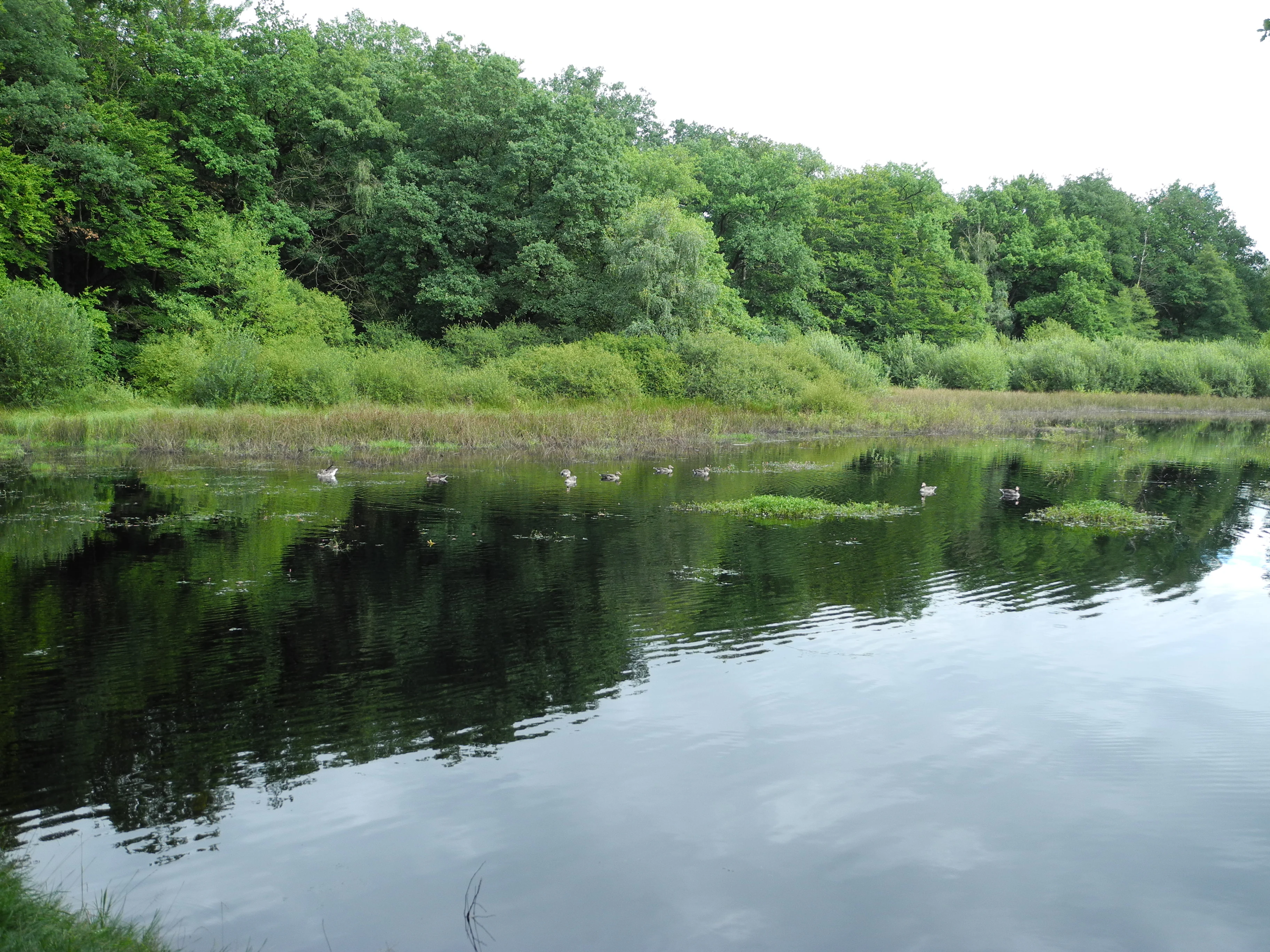
A calm, dark-surfaced pond surrounded by lush green deciduous forest and marshy vegetation, reflecting the sky and trees.
The tranquil waters of Rothbalzer Teich in the Bennhäuser Teich und Rothbalzer Teich nature reserve.

Bennhäuser Teich und Rothbalzer Teich bei Immenhausen history and protected-area timeline

The water bodies that define the reserve have a long human history. Both the Bennhäuser Teich and the Rothbalzer Teich were originally created in the sixteenth century as fish ponds, reflecting the historical role of small impoundments as sources of freshwater fish in the rural Hessian landscape. Over the following centuries, the ponds gradually lost their purely utilitarian character and developed into more natural standing waters.

Formal conservation recognition came much later. On 21 July 1998 the area was designated as the nature reserve (Naturschutzgebiet) with the official number 1633044, securing long-term protection for the ponds, the surrounding damp woodlands, and the headwaters of the Holzkape. In 2011 the reserve was further enhanced through a habitat improvement project at the Bennhäuser Teich, where depressions were created on ground previously planted with spruce to expand the wetland area and promote the development of carr woodland.

Bennhäuser Teich und Rothbalzer Teich bei Immenhausen landscape and geographic character

The landscape of the reserve is shaped by the meeting of lowland forest and small-scale valley hydrology. The protected area sits on the margins of the Reinhardswald, where the broader forested terrain gives way to gently sloping valley ground and shaded stream corridors. The terrain is not dramatic, but it is structurally rich, with alternating hillocks, damp hollows, and the slow-moving reaches of the Holzkape and its feeders.

The two ponds are the visual anchors of the reserve. The Bennhäuser Teich and the Rothbalzer Teich are historic impoundments that now read as near-natural waters, fringed by damp woodland and swampy transitions rather than by engineered embankments. Where the ponds meet the forest edge, swamp vegetation and waterlogged ground create soft, partially open scenery that contrasts with the denser woodland stands on the surrounding slopes.

Bennhäuser Teich und Rothbalzer Teich bei Immenhausen ecosystems, habitats, and plant life

Ecologically, the reserve is defined by the interplay between forest, springs, and standing water. The protected forests include structurally diverse stands that incorporate swampy and waterlogged sections, an unusual habitat combination in this part of Hesse. The presence of stagnant and slow-flowing water, along with seepage zones, supports a range of wetland vegetation types and transitional communities between forest and open water.

The hydrological backbone of the site is the upper Holzkape and its source brooks, which flow through the reserve and feed the two ponds. This network of small streams creates a sequence of microhabitats, from shaded brook margins to open pond edges. Habitat improvement work, including the 2011 creation of additional wet depressions at the Bennhäuser Teich, has been designed to encourage the development of carr woodland (Bruchwald) and to expand the area of suitable wetland habitat.

Bennhäuser Teich und Rothbalzer Teich bei Immenhausen wildlife and species highlights

The reserve is particularly notable for its amphibian and dragonfly fauna. The ponds and the surrounding damp woodland provide breeding and hunting habitat for several amphibian species, while the still waters and sedge margins support a diverse community of dragonflies. The reserve's standout wildlife value is the presence of the Große Moosjungfer, a dragonfly for which this is the only known site within the entire Regierungsbezirk Kassel, making the area of regional importance for the species' conservation.

Beyond these flagship species, the mosaic of ponds, brooks, wet woodland, and forest creates conditions for a broader community of wetland-associated fauna, including invertebrates tied to standing and slow-flowing waters, as well as forest birds and small mammals moving between the dense woodland and the more open wetland edges.

Bennhäuser Teich und Rothbalzer Teich bei Immenhausen conservation status and protection priorities

From a conservation perspective, the reserve's importance is disproportionate to its size. By protecting the headwaters of the Holzkape, two historic pond systems, and the surrounding damp forest in a single designated area, it secures a habitat mosaic that would otherwise be vulnerable to forestry changes, drainage, or changes in land use. The presence of the Große Moosjungfer, with its only known Regierungsbezirk Kassel occurrence here, gives the site an outsized regional significance for invertebrate conservation.

Active management has reinforced the reserve's value. The 2011 project at the Bennhäuser Teich, which converted former spruce monoculture into additional wetland depressions designed to support carr woodland development, illustrates the kind of targeted intervention used to expand habitat availability and improve connectivity between the aquatic and forest systems.

Top sights and standout views in Bennhäuser Teich und Rothbalzer Teich bei Immenhausen

The reserve's highlights include the pair of sixteenth-century fish ponds, the Bennhäuser Teich and the Rothbalzer Teich, which have evolved from utilitarian impoundments into ecologically valuable near-natural waters. Equally noteworthy is the upper course of the Holzkape stream, whose source brooks thread through the protected forest and feed both ponds.

The site is also distinguished by its rare dragonfly fauna, especially the Große Moosjungfer, recorded here as the only known population in the Regierungsbezirk Kassel, and by ongoing habitat restoration work that has converted former spruce stands into expanding wetland and carr woodland.

Monthly climate preview

Long-term annual temperature and precipitation patterns from representative coordinates

Bennhäuser Teich und Rothbalzer Teich bei Immenhausen Climate and Temperature Normals

Representative coordinates for Bennhäuser Teich und Rothbalzer Teich bei Immenhausen record long-term temperature swings alongside steady monthly precipitation averages from 1991 through 2020. Examining the complete twelve-month statistical profile reveals broader shifts across seasonal temperature maximums and minimums.
Annual mean8 °C
-1 °C18 °C
Jan-1°
Feb
Mar
Apr
May12°
Jun16°
Jul18°
Aug18°
Sep14°
Oct
Nov
Dec
Warmest month
July

18 °C

Coolest month
January

-0.6 °C

Wettest month
July

2.5 mm/day

Driest month
April

1.5 mm/day

Park location guide

Geography guide, regional context, and park location map for Bennhäuser Teich und Rothbalzer Teich bei Immenhausen

Bennhäuser Teich und Rothbalzer Teich bei Immenhausen park geography, regions, and map view in Germany

Understand where Bennhäuser Teich und Rothbalzer Teich bei Immenhausen sits in Germany through a broader geographic reading of the surrounding landscape, nearby location context, and its mapped position within the national park landscape.

How Bennhäuser Teich und Rothbalzer Teich bei Immenhausen fits into Germany

Germany is a federal republic in Western and Central Europe with a population of over 83 million across sixteen constituent states. It is Europe's largest economy by nominal GDP and a major global exporter and importer. The capital is Berlin, and the country borders Denmark, Poland, Czech Republic, Austria, Switzerland, France, Luxembourg, Belgium, and the Netherlands.

Wider geography shaping Bennhäuser Teich und Rothbalzer Teich bei Immenhausen in Germany

Germany is located in Western and Central Europe, spanning 357,022 km². It borders Denmark to the north, Poland and the Czech Republic to the east, Austria and Switzerland to the south, and France, Luxembourg, Belgium, and the Netherlands to the west. The country has coastlines on the Baltic Sea and North Sea to the north, with the Alps located in the southern region.

Map view of Bennhäuser Teich und Rothbalzer Teich bei Immenhausen

Use this park location map to pinpoint Bennhäuser Teich und Rothbalzer Teich bei Immenhausen in Germany, understand its exact geographic position, and read its mapped placement within the surrounding landscape more clearly.

Pigeon | © OpenStreetMap contributors

Location context for Bennhäuser Teich und Rothbalzer Teich bei Immenhausen

Hessen

Visualizing the historic impoundment ponds, spring brooks, and damp woodland habitats

Bennhäuser Teich und Rothbalzer Teich bei Immenhausen Landscapes and Scenery

Photographic records reveal the distinct valley terrain and forest edge environments of Bennhäuser Teich und Rothbalzer Teich bei Immenhausen. Visual documentation highlights the protected wetlands, shaded watercourses, and rich ecological structure of the northern Hessian nature reserve.

A calm, dark-surfaced pond surrounded by lush green deciduous forest and marshy vegetation, reflecting the sky and trees.

Park atlas

Discover adjacent forest reserves, wetland habitats, and regional nature parks

Explore Protected Areas Near Bennhäuser Teich und Rothbalzer Teich bei Immenhausen

Compare Bennhäuser Teich und Rothbalzer Teich bei Immenhausen with nearby protected landscapes, forest reserves, and valley wetlands across the northern Hessian countryside. Expanding your regional search reveals connected woodland ecosystems and diverse natural habitats throughout the surrounding terrain.
A soft watercolor illustration depicting a green, marshy landscape with small pools of water, a line of forest, and rolling hills in the background under a pale sky.
Nature reserveHesse
About 3.8 km away#1 closest

East

Bruch an der Eichkanzel im Reinhardswald: Protected Nature Reserve Geography in Hesse

Mapped birch swamp forests and highland bog terrain

Examine the geographic profile of Bruch an der Eichkanzel im Reinhardswald, a nature reserve in Hesse defined by its upland plateau. Learn about the interaction between its birch swamp forests and open moorland habitats, characterized by sphagnum mosses and aquatic features, within the broader context of the Reinhardswald forest region.

Area
0.175 km²
Established
1992
Relief
Upland
Scope
Terrestrial
Watercolor painting of a calm wetland landscape with soft green trees along the water edge under a light, misty sky.
Nature reserveHessen
About 3.9 km away#2 closest

West

Rothenberg bei Burguffeln Protected Wetland Landscape and Nature Reserve in Hessen

A specialized pond and meadow mosaic in the Hessian lowlands

Rothenberg bei Burguffeln preserves a vital wetland complex near Immenhausen, structured across three distinct sections, including the Rothenküler Teich and Tonkaule. The area represents a significant example of culturally shaped lowland geography, blending historic aquaculture with contemporary habitat management. Its protected status reflects a commitment to maintaining intricate riparian corridors and meadow ecosystems within the wider Hessian countryside.

Area
0.278 km²
Established
1983
Watercolor painting of a soft landscape featuring green trees and rolling hills in muted tones against a white background.
Nature reserveGermany
About 5.3 km away#3 closest

East

Bruchwald am Gahrenberg Nature Reserve: A Protected Wetland Atlas of the Reinhardswald

Mapped terrain, bog woodland, and hydrological headwaters in Hessen

Located in the Reinhardswald forest massif, Bruchwald am Gahrenberg protects critical marsh and bog woodland habitats. The area serves as a primary source for regional streams, offering a dense, spring-fed landscape that stands out within the broader northern German wilderness.

Area
0.41 km²
Established
1992
Relief
Upland
Climate
Temperate
A soft watercolor illustration of a winding stream flowing through a green meadow with rolling hills in the background and a small cluster of pine trees in the foreground.
Nature reserveHessen
About 7.2 km away#4 closest

Southwest

Jungfernbach und Brandteich bei Calden: Protected Forest and Stream Valley Geography

Regional nature reserve landscape located in northern Hessen

Examine the mapped boundaries and natural terrain of Jungfernbach und Brandteich bei Calden. This nature reserve offers a detailed look at lowland stream corridors, pond ecosystems, and riparian forest patches nestled within the rolling landscape of northern Hessen, reflecting the region's diverse protected land character.

Area
0.343 km²
Established
1985
A horizontal watercolor illustration depicting rolling green hills, patches of forest, and a calm river in the foreground, rendered in soft, pastel tones.
Nature reserveHesse
About 8.5 km away#5 closest

South

Kragenhof bei Fuldatal Nature Reserve: Mapped Floodplain Landscapes in Hesse, Germany

Protected riparian ecosystems and river meander geography

Located in the state of Hesse, Kragenhof bei Fuldatal is a significant nature reserve protecting a complex mosaic of Fulda River floodplain habitats. The area features shifting currents, small wooded islands, and open grassland within a distinctive meander-driven landscape. Explore the geographic boundaries and ecological structure of this important regional waterbird refuge.

Area
0.077 km²
Established
1981
Nature reserveHesse
About 8.7 km away#6 closest

West

Kelzer Teiche Nature Reserve: Mapped Geography and Protected Wetland Boundaries in Hesse

A historic managed fishpond landscape in the Kassel region of northern Germany.

Kelzer Teiche encompasses 18.5 hectares of lowland countryside defined by its twin fishponds and fringe habitats. This nature reserve plays a recognizable role in the regional network of protected sites in Hesse, offering essential shelter for reed dwelling and migratory birds within a broader agricultural setting.

Area
0.185 km²
Established
1977
Water
Major water bodies
A horizontal watercolor painting showing a soft, hazy landscape with green hills, patches of grass, and purple-tinted distant mountains under a white sky.
Nature reserveLandkreis Kassel
About 11 km away#7 closest

Southwest

Keischel bei Weimar: Nature Reserve Protected Area and Regional Geography

A calcareous grassland mosaic in the Landkreis Kassel district

Keischel bei Weimar preserves a 19.7-hectare landscape defined by Muschelkalk limestone bedrock and traditional agricultural practices. This nature reserve serves as a critical refuge for specialized flora and insect species, showcasing the value of integrated land management within the broader West Hessian Depression and northern Hesse regional geography.

Area
0.197 km²
Established
1992
Relief
Upland
Climate
Temperate
A soft watercolor painting of rolling green and yellow hills under a clear sky, featuring sparse shrubbery and a gentle, layered horizon.
Nature reserveHessen
About 11 km away#8 closest

Northwest

Mittelberg bei Hofgeismar: Nature Reserve and Protected Calcareous Grassland Site

A high-quality conservation landscape located in northern Hessen, Germany.

This nature reserve protects an ecologically rich slope habitat west of Hofgeismar. Defined by its sun-exposed calcareous soil and dry grassland, the site supports ten orchid species and a diverse assemblage of Red List butterflies. It stands as a textbook example of a small, high-density biodiversity hotspot embedded within the broader agricultural geography of the Kassel district.

Area
0.432 km²
Established
1991
Relief
Upland
Climate
Temperate

Common questions about visiting, size, designation, and location context for Bennhäuser Teich und Rothbalzer Teich bei Immenhausen

Bennhäuser Teich und Rothbalzer Teich bei Immenhausen FAQs for park facts, access, geography, and protected area context

Find quick answers about Bennhäuser Teich und Rothbalzer Teich bei Immenhausen, including protected-area facts, park geography, trail and visitor context, and how the park fits into its surrounding country and regional landscape.
MoriAtlas Explorer

Continue Your Protected Areas Search Across the Global Atlas

Deepen your exploration by continuing the structured search for national parks and protected areas worldwide. Utilize the comprehensive filtering capabilities to compare different conservation landscapes and refine your understanding of global park geography. Discover more about the distribution and characteristics of protected natural areas.

Global natural geography