Mori Atlas logo
Protected areaBokak Atoll

Mapping the undisturbed reef structures and drought adapted scrublands of a remote Pacific island ecosystem

Bokak Atoll: A Remote Protected Landscape and Coral Atoll Geography in the Marshall Islands

Bokak Atoll stands as the most northerly and isolated coral structure within the Marshall Islands, offering a rare glimpse into a minimally disturbed Pacific ecosystem. This remote protected area features a crescent shaped reef ring enclosing a unique perched lagoon, which sits higher than the surrounding ocean surface due to the atoll's specific geography. The land is characterized by arid adapted shrublands and dense seabird colonies that remain free from nonnative plant and animal species, providing critical insights into the pristine natural terrain of the northern Ratak Chain.

uninhabited atollcoral atollremote Pacificpristine ecosystemseabird breeding colonynorthern Ratak Chain

Bokak Atoll

Protected area

Park overview

Structured park overview, official facts, and landscape profile for Bokak Atoll

Bokak Atoll park facts, protected area profile, and essential visitor context

Review the core facts for Bokak Atoll, including designation, size, terrain, visitor scale, habitats, and operating context in one park-focused overview.

About Bokak Atoll

Bokak Atoll is one of the most remarkable natural areas in the Marshall Islands, defined as much by what is absent as by what is present. There are no residents, no coconut forests, no developed freshwater resources, and no invasive mammals such as the black rat, even though wrecked fishing vessels litter the reefs. What remains is a nearly intact coral atoll ecosystem, set in the far northern reaches of the Ratak Chain and surrounded by deep ocean.

The atoll takes the form of a rough crescent of low islets on an otherwise continuous reef, broken only by a single narrow channel on the western side. The dry land totals little more than three square kilometers across roughly 36 islets, while the lagoon inside the ring covers about 78 square kilometers. Because prevailing winds drive seawater over the windward reef faster than it can drain out through the single westerly passage, the lagoon sits as a perched body of water, a few feet above the surrounding tide, with a famously calm surface. This unusual hydrology shapes the entire biological character of the atoll.

The vegetation of Bokak is sparse, low, and unusually intact. Only nine native plant species grow here, and none are exotics. Drought, rapid drainage, and the absence of a Ghyben-Herzberg freshwater lens prevent coconut palms from establishing. Instead, the islets are clothed in open scrub of tree heliotrope, with dense shoreline stands of beach naupaka, scattered ʻihi, ʻilima, alena, and rare patches of Pisonia grandis on the larger islands. Birdlife is the atoll's most striking feature: enormous colonies of seabirds breed on the northern islets, with Christmas shearwaters relying on Bokak as their only known breeding ground, and migratory shorebirds joining the resident species in season.

Bokak also has a strongly human story, even though no one lives on it today. Traditional Marshallese chiefs treated it as hunting and gathering grounds for seabirds and turtles, Spanish explorers charted it in the sixteenth century, and successive colonial administrations in the German and Japanese periods left barely any imprint because the atoll could not truly support settlement. Twentieth-century episodes, including wartime outposts, a failed proposal to use the lagoon as a massive waste dump, and its place in the saga of a missing Hawaiian sailor, all reinforce the impression of a place whose isolation protected it more effectively than any policy could have. In 2025, Bokak was included in the Marshall Islands' first designated marine sanctuary.

Quick facts and research context for Bokak Atoll

Bokak Atoll lies in the northern Ratak Chain of the Marshall Islands, about 685 kilometers north of Majuro and around 560 kilometers south-southeast of Wake Island. It is the most remote atoll in the country and remains entirely uninhabited. The atoll consists of around 36 islets on an approximately 129 square kilometer reef platform, of which only about 3 square kilometers is dry land. The lagoon, around 78 square kilometers in area, sits slightly above the mean ocean tide because of wind-driven water inflow and a single narrow reef passage. The climate is semi-arid, with mean annual rainfall under 1,000 millimeters, which prevents the formation of a freshwater lens and eliminates coconut palms from the landscape.

Protection and recognition

Documented protection scope and international recognition records for Bokak Atoll

Bokak Atoll Protection Status and Designated Conservation History

Bokak Atoll maintains a mixed protection scope established through designated conservation measures enacted in 2025. Official records outline the formal designation history and management framework associated with the protected landscape.

Protection details

Protection scope
Mixed
Designated year
2025
Transboundary protection
No
Park context

Deeper park guide and search-rich context for Bokak Atoll

Bokak Atoll history, landscape, wildlife, and travel context

Explore Bokak Atoll through its history, landscape character, ecosystems, wildlife, conservation priorities, cultural context, and seasonal travel timing in a structured park guide built for atlas discovery and search intent.

Why Bokak Atoll stands out

Bokak is best known for being one of the least disturbed tropical Pacific ecosystems, with vegetation, birdlife, and reefs that have been shielded from invasive species by the atoll's sheer remoteness. It supports only about nine native plant species, none of them introduced, and the shrublands and bunchgrass savannas here are considered among the finest examples of such vegetation in the entire Pacific region. The atoll is also notable for hosting major seabird colonies, including breeding populations of boobies, frigatebirds, terns, and shearwaters, and for its healthy but low-diversity reef fauna dominated by giant clams, sharks, snapper, and an estimated hundred stony coral species.
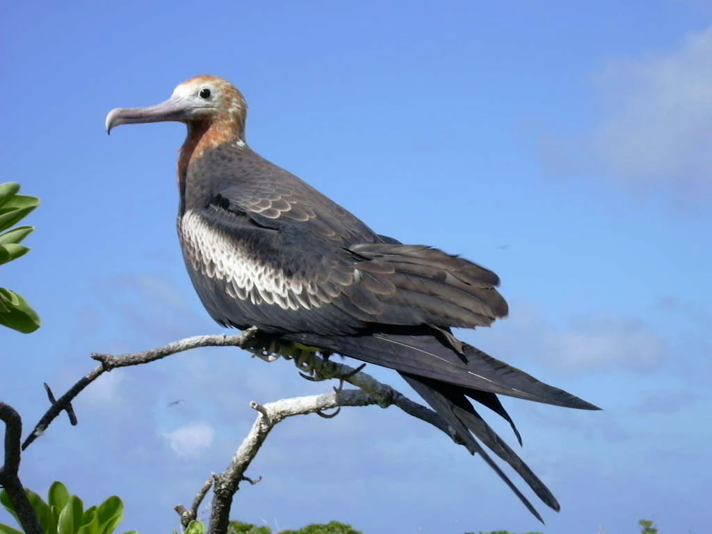
A medium close-up shot of a female frigatebird with a white throat and dark brown plumage perched on a bare, thin tree branch against a clear blue sky.
A female frigatebird perched on a branch in Bokak Atoll.

Bokak Atoll history and protected-area timeline

Although humans reached the Marshall Islands around two thousand years ago, Bokak appears to have no traditional Marshallese artifacts associated with long-term settlement. Its climate and soils are simply too harsh to support habitation. Instead, the atoll was used as a hunting and gathering territory, especially for seabirds and their eggs, by inhabitants of other northern Ratak atolls. Together with the neighboring uninhabited atolls of Bikar and Toke, Bokak was the hereditary property of the Iroji Lablab, or paramount chiefs, of the Ratak chain, and exploitation of its wildlife was governed by customary rules.

The first European sighting is recorded in 1526, when the Spanish explorer Toribio Alonso de Salazar, commanding the Loaisa expedition after its original leaders had died, charted the atoll as San Bartolome. Spanish naval officer Fernando Quintano returned to explore it in 1795, and a parade of other Western ships passed over the following three centuries, none of which attempted settlement, perhaps because more fertile atolls lay nearby.

In 1885, the German Empire took possession of the Marshall Islands and incorporated them into German New Guinea in 1906. Treating uninhabited atolls as unclaimed territory, the Germans seized Bokak as government property despite the protests of the local paramount chiefs. With Japanese expansion in the Meiji era, the German administration noted Marshallese complaints of Japanese bird poaching more as a violation of the protectorate's sovereignty than as a concern for the islanders themselves. In 1914, Japan occupied the Marshall Islands and inherited Bokak as government property, but again did not attempt to develop it.

The only sustained physical development came during World War II, when Japan built a small seaplane and communications outpost on Sibylla Island. In March 1943, the garrison was withdrawn to Wake Island in part because the troops could not feed themselves, and the abandoned facility was bombed by US air elements in April 1944. After the war, the Marshall Islands fell under American administration, and a landing party from Kwajalein searched Bokak in September 1945 for any surviving Japanese personnel without finding any.

The atoll's mid-twentieth-century history was shaped by nuclear testing elsewhere in the Marshalls. Aerial surveys after the Castle Bravo test on Bikini Atoll in 1954 measured residual radiation on Sibylla Island, and Bokak itself was seriously surveyed in 1957 as a candidate site for Operation Hardtack tests, only to be passed over in favor of reusing Bikini, Enewetak, and the Nevada Test Site. In 1953, the USS Steuben County also stopped at Bokak while en route from the United States to Asia to look for rumored Japanese holdouts, finding only wartime debris.

In 1979, Bokak figured in the disappearance of Scott Moorman and four companions from Maui, Hawaii, whose small boat was eventually recovered on the atoll with Moorman's buried remains in 1988. In 1988, a U.S. company briefly proposed using the Bokak lagoon as a dumpsite for millions of tons of solid waste, a plan that did not proceed. In 2003, two Texas amateur radio operators camped on Sibylla Island and inaugurated the first Taongi ham station, V73T, under the IOTA reference OC-263. Today the atoll bears the visible remnants of this stratified history: an abandoned camp, several wrecked vessels, and the corroding skeleton of a former Japanese landing craft. In 2025, the atoll was included in the Marshall Islands' first designated marine sanctuary.

Bokak Atoll landscape and geographic character

Bokak is a classic example of a remote central Pacific coral atoll, its form a rough crescent stretching roughly 18 kilometers from north to south and about 9 kilometers across. The reef ring is almost unbroken, with the only serious gap a narrow channel about 20 meters wide on the leeward western side. Ten named islets lie along the eastern and southeastern arc of the reef, and these, together with additional unnamed cays, make up the only dry land in the entire atoll. The largest is Sibylla, a long, narrow islet of around 7 kilometers in length but only a few hundred meters wide, while Kamwome to its northeast and Bokak Island to its south are the next most significant.

Geologically, the reef platform is thought to rest on a deep column of reef material atop an ancient basalt base, the eroded summit of a long-extinct submarine volcano rising some 3,000 meters above the surrounding seafloor. Inland from the shorelines, high ridges of boulders and sand record the atoll's long history of severe storms, while the central parts of the wider islets are floored by sand and rubble flats. Soils are immature and coarsely textured, dominated by coral sand and gravel with almost no organic accumulation, which prevents the growth of trees such as coconut palms.

The lagoon is shallow, generally not exceeding about 30 meters in depth, and dotted with coral heads and small patch reefs. Its most striking physical feature is its perched water surface: inflow over the windward reef is greater than outflow through the single leeward channel, so the lagoon actually sits up to a meter above the surrounding tide, producing an unusually calm mirror-like surface.

Climatically, Bokak is the driest of all the Marshall Islands atolls, semi-arid in character despite its tropical setting. Mean annual temperature is around 28 degrees Celsius, while mean annual rainfall is below 1,000 millimeters and falls mainly in late summer. Prevailing winds are north to north-easterly, and they play a major role in shaping both the reef itself and the perched lagoon.
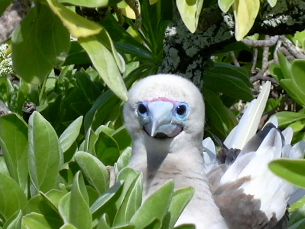
Close-up of a white Red-footed Booby with a bright blue beak nestled among lush green, waxy leaves.
A Red-footed Booby nesting within the native Beach Naupaka vegetation on Bokak Atoll.

Bokak Atoll ecosystems, habitats, and plant life

The natural environment of Bokak is shaped almost entirely by drought. With insufficient rainfall, very free-draining coral soils, and high temperatures, the atoll has no freshwater Ghyben-Herzberg lens beneath it, and so it cannot support coconut palms or any of the dense broadleaf forests typical of better-watered Pacific atolls. What survives instead is a thin but carefully adapted plant community of only nine native species, none of them introduced.

The most widespread formation is a low, open scrub of tree heliotrope, generally two to six meters tall, with occasional taller individuals. Beneath it lies a sparse understory of beach maupaka near the shores, while inland one finds bunchgrass, the small succulents ʻihi and ʻilima, and the sprawling alena, especially on broken coral gravel. The northern and central islets carry some of the finest examples of these Heliotropium, Scaevola, and Sida-dominated shrublands, as well as extremely rare, very small stands of Pisonia grandis, a tree normally associated with much richer Pacific forests. Pure, dense stands of beach naupaka shrubland, locally mixed with tree heliotrope, cover much of southern Sibylla and almost the entirety of its northeastern portion, and these dense shrublands represent the best examples of this vegetation type in the Marshall Islands and arguably across the broader Pacific.

The aquatic vegetation of the lagoon edge is also minimal: sparse coralline algae, encrusting coral fragments and shells, and scattered patches of green seaweed.
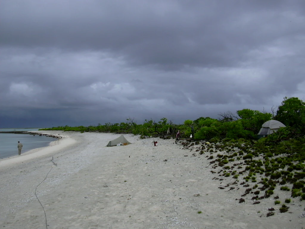
A sandy beach shoreline at Bokak Atoll with two small camping tents set up among coastal vegetation under a dark, cloudy sky.
A remote campsite on the sandy shoreline of Sibylla Island in Bokak Atoll, under overcast skies.

Bokak Atoll wildlife and species highlights

Bokak's wildlife is dominated by seabirds, whose colonies are among the largest and least disturbed in the central Pacific. Roughly 26 species of sea and shorebirds have been recorded, and the atoll supports breeding populations of brown boobies and red-footed boobies, great frigatebirds, red-tailed tropicbirds, sooty terns, white terns, and brown noddies, with the reef heron possibly breeding as well. The densest seabird colonies are concentrated on the three northernmost islets of North, Kamwome, and one unnamed cay.

Bokak's isolation also gives it singular ornithological importance: it is the only known breeding ground of the Christmas shearwater and possibly of Bulwer's petrel. Migratory shorebirds such as the bristle-thighed curlew, turnstone, wandering tattler, golden plover, and sanderling visit regularly. The most common terrestrial fauna is limited: the Polynesian rat is present on Sibylla, but the more aggressive black rat, common on many Pacific islands, does not appear to be established here despite numerous wrecked fishing vessels on the eastern reef. Snake-eyed skinks and large hermit crabs are common.

Marine life is healthy but low in diversity, again likely a function of isolation. The lagoon and its reef flats hold abundant giant clams of the family Tridacnidae, although the largest species, Tridacna gigas, is notably rare. Smaller bivalves are present but few in number. The reef fish community is dominated by emperor breams, parrotfish, and red snappers, accompanied by moray eels and grey reef sharks. Marine turtles are assumed by traditional custom to have once been present and harvested, although modern observers have not confirmed current populations. Approximately 100 stony coral species and two soft coral species have been recorded around the atoll, supporting the rich reef framework visible from satellite and from the surface alike.
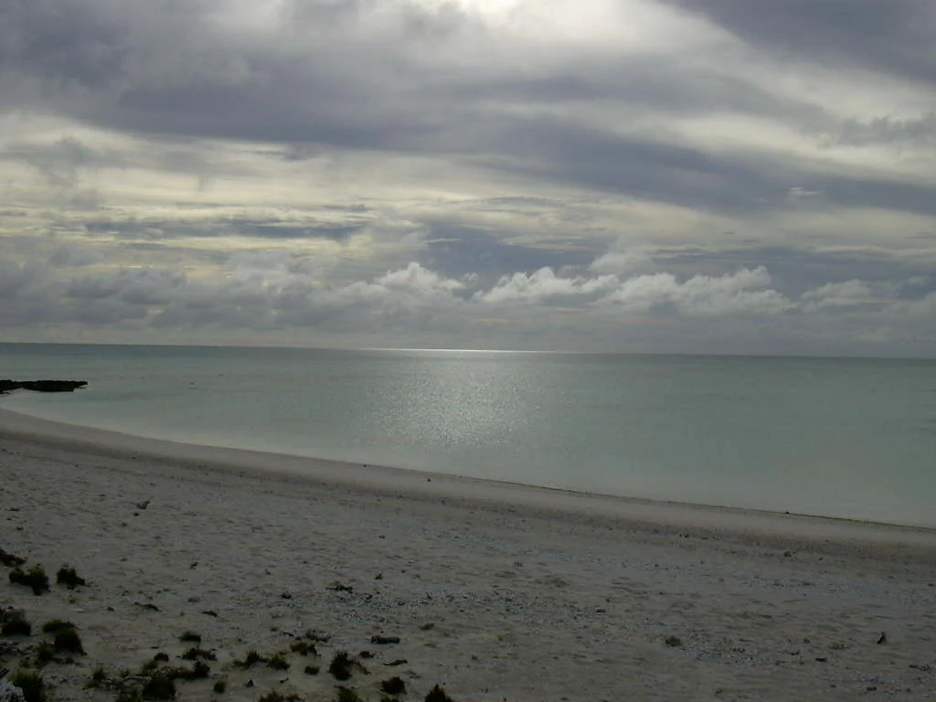
A wide angle view of a white sandy beach meeting the calm, shallow waters of a lagoon under a cloudy sky.
A view of the beach and lagoon at Bokak Atoll.

Bokak Atoll conservation status and protection priorities

The principal conservation value of Bokak is its pristine character, a condition that has been maintained not by deliberate management but by the atoll's extraordinary physical isolation. Because no humans live on it and because invasive species such as the black rat and exotic plants have not reached it, the atoll offers one of the most intact tropical Pacific island ecosystems in existence. The vegetation communities present here, especially the dense Heliotropium and naupaka shrublands and the native bunchgrass savannas, have been described as among the finest surviving examples in the entire Pacific region.

The seabird populations are similarly undisturbed by introduced predators, allowing Bokak to retain globally significant breeding populations, including the only known breeding site for Christmas shearwater and likely Bulwer's petrel. The marine environment also remains ecologically intact, with healthy predator populations such as grey reef sharks and abundant giant clams, alongside approximately 100 species of stony corals.

Bokak's conservation profile has been tested by proposals that would have profoundly altered it, including a 1988 plan by Admiralty Pacific to use the lagoon as a regional solid-waste dump, which foresaw millions of tons of waste and a fleet of garbage ships arriving each year. That proposal did not proceed. In 2025, the atoll was formally included in the Marshall Islands' first designated marine sanctuary, providing institutional recognition of the conservation significance that geography and isolation have long protected.

Bokak Atoll cultural meaning and human context

Although uninhabited, Bokak has an important place in traditional Marshallese cultural geography. Together with the neighboring uninhabited atolls of Bikar and Toke, it was the hereditary property of the Iroji Lablab, or paramount chiefs, of the Ratak chain. Hunting of seabirds and turtles and gathering of eggs from the atoll were governed by customary rules enforced by these chiefs, making Bokak a significant cultural-natural resource in the regional customary system rather than simply a remote and empty place.

European contact with Bokak dates to the Spanish maritime expeditions in the 1520s, when Toribio Alonso de Salazar charted it as San Bartolome, and the atoll was revisited by Fernando Quintano in 1795. Successive colonial administrations under the German Empire and then Japan treated Bokak essentially as unoccupied government property, with minor episodes of Japanese bird poaching prompting German complaints about sovereignty rather than local resource rights. World War II brought a small Japanese seaplane and communications outpost on Sibylla Island, abandoned in 1943, and later American military surveys, while postwar visitors included American servicemen looking for rumored Japanese stragglers. Today the cultural landscape of Bokak includes the loose mixture of stories, customary tenure, and physical remains that mark it as a place where Pacific island traditions and twentieth-century global history overlapped without ever producing a settled community.

Top sights and standout views in Bokak Atoll

Bokak Atoll stands out as one of the last essentially untouched coral atolls in the central Pacific, with a vegetation cover of only nine native species and no introduced plants or mammals of note. Its perched lagoon, sitting about a meter above the surrounding ocean thanks to a single narrow reef passage, gives it an unusually calm and visually striking interior water body. The atoll is globally important for seabirds, hosting the only known breeding ground of the Christmas shearwater and supporting dense colonies of boobies, frigatebirds, and terns across its northern islets. Its reef ecosystem is healthy if relatively low in diversity, with abundant giant clams, grey reef sharks, parrotfish, and about 100 stony coral species. The atoll's 2025 inclusion in the Marshall Islands' first designated marine sanctuary formalizes its status as a place whose protection begins with its geography.

Best time to visit Bokak Atoll

Bokak is uninhabited and not a typical visitor destination in the conventional sense, so general seasonal guidance is more appropriate than precise scheduling. Rainfall is concentrated in late summer, and mean annual totals are under 1,000 millimeters, so dryer conditions tend to prevail outside this wetter window. Prevailing winds are north to north-easterly throughout the year, and severe storms have historically shaped the boulder and sand ridges that run across the islets. For anyone considering a visit, the calmer conditions typically found outside the late-summer rainfall peak, combined with awareness that the lagoon is exceptionally sheltered because of its perched water level, tend to favor the drier months for any landing, exploration, or wildlife observation.

Monthly climate preview

Long-term representative records tracking monthly temperature and rainfall patterns

Bokak Atoll Climate Normals: Annual Temperature and Precipitation Rhythm

Bokak Atoll records sustained warm temperatures alongside distinct monthly precipitation variations across the year. Reviewing the comprehensive monthly climate normals reveals detailed long-term thermal and moisture rhythms for this protected location.
Annual mean27 °C
26 °C28 °C
Jan26°
Feb26°
Mar26°
Apr27°
May27°
Jun28°
Jul28°
Aug28°
Sep28°
Oct28°
Nov28°
Dec27°
Warmest month
August

28.1 °C

Coolest month
February

26.1 °C

Wettest month
October

4 mm/day

Driest month
January

0.5 mm/day

Park location guide

Geography guide, regional context, and park location map for Bokak Atoll

Bokak Atoll park geography, regions, and map view in Marshall Islands

Understand where Bokak Atoll sits in Marshall Islands through a broader geographic reading of the surrounding landscape, nearby location context, and its mapped position within the national park landscape.

How Bokak Atoll fits into Marshall Islands

The Marshall Islands is a sovereign island nation in Oceania, located in the Micronesia region of the Northwestern Pacific Ocean. The territory consists of 29 coral atolls and five main islands plus over 1,200 very small ones, divided across two island chains: Ratak in the east and Ralik in the west. The country gained independence from the United States in 1979 and maintains a Compact of Free Association with the US. It is notable for having the highest proportion of water to land of any sovereign state, at 98.62%.

Wider geography shaping Bokak Atoll in Marshall Islands

The Marshall Islands is located in the Micronesia region of the Northwestern Pacific Ocean, west of the International Date Line and north of the equator. The territory is composed of 29 coral atolls and five main islands, plus approximately 1,220 very small islets, divided into two island chains: Ratak (eastern) and Ralik (western). Maritime boundaries are shared with Wake Island to the north, Kiribati to the southeast, Nauru to the south, and the Federated States of Micronesia to the west.

Map view of Bokak Atoll

Use this park location map to pinpoint Bokak Atoll in Marshall Islands, understand its exact geographic position, and read its mapped placement within the surrounding landscape more clearly.

Pigeon | © OpenStreetMap contributors

Explore photographic records of coral reefs, scrub vegetation, and pristine protected terrain.

Bokak Atoll Photos and Landscape Scenery: Visualizing Remote Pacific Habitats

Visual documentation captures the remote coral islets, perched lagoons, and undisturbed shrublands defining this isolated marine sanctuary. Examining authentic park imagery reveals the distinct terrain, sparse drought-adapted flora, and protected coastal habitats shaping the region.

A medium close-up shot of a female frigatebird with a white throat and dark brown plumage perched on a bare, thin tree branch against a clear blue sky.

A grey reef shark swimming horizontally through turquoise, open water.

Close-up of a white Red-footed Booby with a bright blue beak nestled among lush green, waxy leaves.

A sandy beach shoreline at Bokak Atoll with two small camping tents set up among coastal vegetation under a dark, cloudy sky.

A wide angle view of a white sandy beach meeting the calm, shallow waters of a lagoon under a cloudy sky.

Park atlas

Compare remote Pacific island ecosystems and regional coral atolls.

Explore Other Parks Near Bokak Atoll and Protected Marine Sanctuaries

Browse related protected areas and marine reserves to examine how isolated coral atolls compare across the wider Pacific region. Extended regional mapping places Bokak Atoll within a broader network of pristine island wildlife habitats and remote conservation zones.
Protected areaMarshall Islands
About 283 km away#1 closest

Southeast

Bikar Atoll Protected Area: Geographic Overview of a Remote Marshall Islands Coral Atoll

A pristine, uninhabited coral sanctuary and critical Pacific marine habitat.

Bikar Atoll is a remote, diamond-shaped coral ring located in the Ratak Chain of the Marshall Islands. Defined by its shallow lagoon, continuous reef structure, and arid islets, the atoll serves as a vital nesting site for seabirds and green turtles. This protected area remains one of the most ecologically undisturbed sites in the Pacific, offering rare insight into natural atoll morphology and island conservation.

Area
0.5 km²
Established
2025
Relief
Lowland
Climate
Tropical
Protected areaMarshall Islands
About 392 km away#2 closest

Southwest

Rongerik Atoll Protected Area: Mapping the Marshall Islands Coral Landscape

Remote coral atoll geography and lagoon structures in the Ralik Chain.

Rongerik Atoll presents a textbook example of Pacific atoll geography, where a cluster of small islets encloses an expansive lagoon. As a protected area located in the remote Marshall Islands, this site serves as a vital point of study for understanding coral reef systems and the isolated island terrain of the Ralik Chain. The landscape provides clear insights into the physical contrast between narrow coral landmasses and the deep interior waters characteristic of the region.

Area
1.68 km²
Relief
Lowland
Climate
Tropical
Access
Remote access
A minimalist watercolor painting featuring soft, light green hills in the foreground and faded, purple-toned mountains in the distant background, all set against a white backdrop.
Protected areaMarshall Islands
About 429 km away#3 closest

Southwest

Rongelap Atoll Protected Area: Geography, Reef Structure, and Marshall Islands Context

Coral atoll terrain in the Pacific Ralik Chain

Located in the Ralik Chain of the Marshall Islands, Rongelap Atoll consists of 61 low-lying coral motus that enclose a lagoon covering 2,600 square kilometers. The atoll serves as a significant geographic study area, known for its distinct reef-built structure and its enduring role in Pacific history. This protected area continues to represent the ecological and cultural complexity of the Micronesian archipelago.

Area
21 km²
Relief
Lowland
Climate
Tropical
Access
Remote access
Protected areaMarshall Islands
About 472 km away#4 closest

Southwest

Ailinginae Atoll Protected Area: Geographic Overview and Mapped Lagoon Systems

Remote coral atoll landscape in the Marshall Islands

Uncover the geographic structure of Ailinginae Atoll, an uninhabited coral ring in the Marshall Islands characterized by its expansive internal lagoon and narrow island segments. This protected area offers significant insight into the terrain of low-lying Pacific atoll ecosystems and their role within the Ralik Chain geographic framework.

Area
2.8 km²
Relief
Lowland
Water
Water-dominated
Protected areaMarshall Islands
About 476 km away#5 closest

South

Ailuk Atoll Protected Area: Geography and Mapped Coral Landscapes in the Marshall Islands

Pacific atoll terrain, lagoon systems, and island geography

Study the geographic composition of Ailuk Atoll, featuring its classic ring of coral islets, deep-water reef passes, and vast central lagoon. This protected area offers insight into the subsidence-driven formation of Marshallese island chains and the enduring human reliance on traditional maritime navigation within a fragile Pacific ecosystem.

Area
5.4 km²
Relief
Lowland
Climate
Tropical
Access
Remote access
Watercolor painting of a landscape showing a body of water surrounded by green land with trees and distant hills, with soft pink and purple washes on the sides
Protected areaMarshall Islands
About 513 km away#6 closest

South

Likiep Atoll: A Mapped Protected Area in the Marshall Islands Ratak Chain

Coral atoll geography and historical colonial landscape features

Likiep Atoll consists of 65 islands encircling a 424 square kilometer lagoon. As a protected area in the Marshall Islands, it offers insight into low lying atoll topography, unique marine environments, and the cultural remnants of successive colonial administrations.

Area
10.26 km²
Relief
Lowland
Climate
Tropical
Access
Remote access
A pale, soft watercolor illustration depicting distant islands or atoll ridges across a calm lagoon, with silhouetted palm trees in the foreground on the left and right.
Protected areaMarshall Islands
About 658 km away#7 closest

South

Kwajalein Atoll Protected Area and Marshall Islands Geographic Landscape Mapping

Pacific coral atoll structure and lagoon geography

Kwajalein Atoll represents a mature coral formation encompassing an immense lagoon within the Ralik Chain. The landscape consists of low-lying islets and interconnected reef structures that define the maritime geography of the Marshall Islands. This assessment provides a focus on the structural, mapped, and physical attributes that distinguish this protected site within the wider Pacific regional context.

Area
16.4 km²
Relief
Lowland
Climate
Tropical
Access
Highly restricted
A watercolor painting showing a panoramic view of soft, green rolling hills, a cluster of trees, and a calm water surface in a light, muted palette.
Protected areaMarshall Islands
About 864 km away#8 closest

South

Majuro: Mapping the Protected Coral Atoll Landscapes and Island Geography of the Marshall Islands

Regional atoll atlas and protected lagoon geography.

Majuro serves as the primary administrative and geographic anchor within the Marshall Islands. This detailed mapping showcases the atoll's signature structure, characterized by 64 narrow islets enclosing a massive, sheltered 295 square kilometer lagoon. Delve into the specific landforms and regional marine geography that define this Pacific protected environment.

Area
9.7 km²
Relief
Lowland
Climate
Tropical
Access
Moderate access

Common questions about visiting, size, designation, and location context for Bokak Atoll

Bokak Atoll FAQs for park facts, access, geography, and protected area context

Find quick answers about Bokak Atoll, including protected-area facts, park geography, trail and visitor context, and how the park fits into its surrounding country and regional landscape.
MoriAtlas Explorer

Continue Your Protected Areas Search Across the Global Atlas

Deepen your exploration by continuing the structured search for national parks and protected areas worldwide. Utilize the comprehensive filtering capabilities to compare different conservation landscapes and refine your understanding of global park geography. Discover more about the distribution and characteristics of protected natural areas.

Global natural geography