Mori Atlas logo
Protected landscapeBoston Harbor Islands National and State Park

Trace the geography of this historic urban archipelago across Massachusetts Bay tidal waters

Boston Harbor Islands National and State Park: Mapping a Unique Coastal Protected Landscape

Boston Harbor Islands National and State Park is a sprawling coastal protected landscape situated just offshore from the city of Boston. This unique archipelago features more than 30 islands and peninsulas, each offering distinct terrain ranging from rocky headlands and sandy beaches to salt marshes and forested uplands. The park serves as a bridge between deep maritime history, including Civil War era fortifications and colonial lighthouses, and a vibrant coastal habitat that supports significant avian populations and marine life.

coastal islandsurban harbornational recreation areastate parkpartnership parkhistoric forts

Boston Harbor Islands National and State Park

Protected landscape

Park overview

Structured park overview, official facts, and landscape profile for Boston Harbor Islands National and State Park

Boston Harbor Islands National and State Park park facts, protected area profile, and essential visitor context

Review the core facts for Boston Harbor Islands National and State Park, including designation, size, terrain, visitor scale, habitats, and operating context in one park-focused overview.

About Boston Harbor Islands National and State Park

Boston Harbor Islands National and State Park represents a distinctive approach to protected landscapes in the United States: a national recreation area woven into an active urban harbor and shared with a state park system. The park stretches across 34 islands and peninsulas in Boston Harbor, from the open outer islands that face Massachusetts Bay to the sheltered inner rocks and peninsulas closer to downtown Boston. Together, these pieces of land form a necklace of small environments that vary significantly in size, exposure, and use.

What sets the park apart is its unusual governance and its unusually dense layering of history. Management is handled by the Boston Harbor Islands Partnership, a body that brings together the National Park Service, the U.S. Coast Guard, Massachusetts agencies, the City of Boston, and nonprofit partners to coordinate care of lands the federal government does not own outright. Day-to-day stewardship is distributed among these partners, allowing each island to be managed by the agency best suited to its character, while the partnership ensures the system as a whole retains a consistent identity.

The park's identity is shaped by centuries of overlapping human presence. Native peoples used the islands seasonally for thousands of years before colonization, drawing on shellfish, migratory birds, fish, and seals, and leaving behind an archaeological footprint that supports a National Register historic district covering 21 islands. After European colonization, the islands were repurposed for coastal defense, quarantine hospitals, almshouses, reform schools, lighthouses, resorts, and industrial uses, and many of these structures remain as visible layers of the contemporary landscape. Today the islands serve as a recreational escape, a heritage corridor, and an ecological refuge within one of America's oldest metropolitan harbors.

Quick facts and research context for Boston Harbor Islands National and State Park

Boston Harbor Islands National and State Park consists of 34 islands and peninsulas scattered across Boston Harbor, within sight of downtown Boston. The park was established on November 12, 1996, combining a federal national recreation area designation with Massachusetts state park lands. It is governed through the Boston Harbor Islands Partnership, which links the National Park Service with state, city, and nonprofit agencies, and the federal government does not own the underlying land.

The park includes three National Historic Landmarks, with Fort Warren, Boston Light, and Long Wharf among its most recognizable heritage sites. Designated an Important Bird Area by Massachusetts, it supports more than 200 bird species and a wide range of coastal and intertidal habitats. The Boston Harbor Islands Archeological District preserves evidence of thousands of years of Indigenous use of the islands, while nearby waters occasionally host humpback, fin, minke, and North Atlantic right whales.

Protection and recognition

Examine the documented protection status and management scope of Boston Harbor Islands.

Boston Harbor Islands National and State Park Protection Status and Recognition

Boston Harbor Islands National and State Park holds a mixed protection scope governed by structured conservation frameworks. Review official designation details and recorded international recognition sources for this protected coastal landscape.

Protection details

Protection scope
Mixed
Transboundary protection
No
Park context

Deeper park guide and search-rich context for Boston Harbor Islands National and State Park

Boston Harbor Islands National and State Park history, landscape, wildlife, and travel context

Explore Boston Harbor Islands National and State Park through its history, landscape character, ecosystems, wildlife, conservation priorities, cultural context, and seasonal travel timing in a structured park guide built for atlas discovery and search intent.

Why Boston Harbor Islands National and State Park stands out

Boston Harbor Islands is best known for being a working urban harbor archipelago where multiple islands, forts, and lighthouses cluster within sight of a major American city. The park's signature attractions include Fort Warren on Georges Island, the still-active Boston Light on Little Brewster Island, and the seasonal ferry landings that bring day visitors to Spectacle Island and Peddocks Island. Equally distinctive is the park's deep archaeological record, which documents continuous Indigenous use of the islands for thousands of years alongside later colonial, military, and institutional histories. The combination of an Important Bird Area designation with sites like the Boston Harbor Islands Archeological District, a National Register historic district, gives the park a layered identity that blends ecology, colonial-era coastal defense, and Indigenous heritage on a single coastal stage.
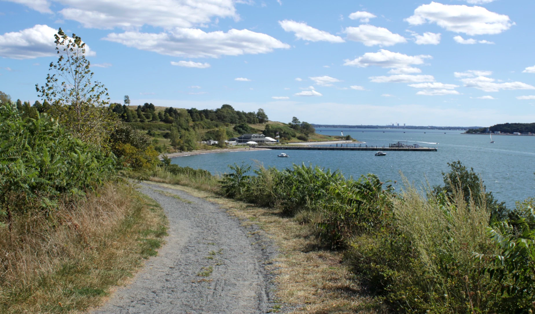
A dirt and gravel path curves through coastal vegetation toward a pier and small building on the shoreline of a bay under a clear blue sky.
A gravel trail on Spectacle Island overlooking the pier, visitor area, and Boston Harbor.

Boston Harbor Islands National and State Park history and protected-area timeline

Human history on the Boston Harbor Islands extends far beyond the park's 1996 establishment, beginning with long Indigenous use that shaped both the islands and the surrounding harbor. The Massachusett Tribe at Ponkapoag, the Mashpee Wampanoag Tribe, the Wampanoag Tribe of Gay Head (Aquinnah), the Nipmuc Nation, and the Narragansett Indian Tribe all have deep historical connections to these islands. People began visiting the islands on a seasonal basis during the Middle Archaic period and intensified their use throughout the Late Archaic and Woodland periods, harvesting shellfish, fish, migratory birds, seals, deer, and raccoon and practicing controlled burning and careful plant management.

During King Philip's War in the 17th century, English colonists forcibly removed hundreds of Native American women, children, and elders from praying towns and interned them on Deer Island, Long Island, Peddocks Island, and Great Brewster Island under harsh conditions. Roughly half of those interned died from starvation or exposure, while others were sold into slavery in the West Indies. Descendants of the affected Tribal Nations still gather on Deer Island each year to commemorate their ancestors.

After colonization, the islands became central to the operation of one of colonial America's busiest ports. They hosted coastal defense installations used during the Revolutionary War, the Civil War, and the two world wars, and they accumulated a complex institutional history that included quarantine hospitals, almshouses, reform schools, military prisons, and internment facilities. Businesses ranging from resorts to waste processing plants operated on individual islands, and key navigation landmarks such as Boston Light were built to guide ships into the harbor. By the 1970s, the islands were largely privately owned, at which point the Commonwealth of Massachusetts began purchasing them to protect their natural resources and develop them for public recreation.

On November 12, 1996, Boston Harbor Islands National Recreation Area was established, creating a federal designation layered over state-owned land and managed through the Boston Harbor Islands Partnership rather than through direct federal ownership. The park's 21-island archaeological district was added to the National Register of Historic Places in 1985, and additional recognition has followed for landmarks such as Fort Warren, Boston Light, and Long Wharf.

Boston Harbor Islands National and State Park landscape and geographic character

The park's landscape is defined by the geology and climate of a temperate Atlantic harbor. The islands and peninsulas sit in a dynamic coastal setting shaped by glaciation, ongoing erosion, and the daily rhythm of tides. Their shorelines take many forms, including rocky headlands, sheltered coves, sandy beaches, low coastal bluffs, and salt marshes tucked into tidal creeks. Together the park includes more than 35 miles of coastline, providing a rich variety of marine and terrestrial edge habitats.

Inner harbor islands tend to be smaller, more altered, and closer to the urban shoreline, while outer islands such as the Brewsters face the open Atlantic and feel wilder and more exposed. Spectacle Island, one of the park's signature ferry destinations, combines elevated drumlin-like terrain with sandy shores, a visitor center, and walking trails that frame sweeping views back toward the city. Peddrocks Island, accessible by ferry from Hingham, offers a mix of forested uplands, beaches, and historic military remains, while places like World's End in Hingham present rolling, open headlands with panoramic harbor views.

The landscapes are continuously reshaped by wind, wave action, and human use. Some islands retain visible scars from quarrying and historic grazing, while others have recovered into meadow, shrub thicket, and woodland. This combination of working harbor geography and recovering natural terrain gives the park a landscape character that is neither fully wild nor fully built, but distinctly coastal and continuously evolving.

Boston Harbor Islands National and State Park ecosystems, habitats, and plant life

Ecologically, the park is a mosaic of small but unusually varied habitats. The islands include intertidal and subtidal zones, rocky and sandy beaches, coastal bluffs, salt marshes, freshwater wetlands, grassy meadows, successional shrublands, and patches of woodland. Because each island has its own size, exposure, and history of human use, plant communities vary significantly from one landmass to the next, producing an unusually high diversity of ecological conditions for a relatively small total area.

Native trees such as eastern cottonwood, quaking aspen, northern red oak, bitternut hickory, and sassafras anchor the wooded areas, while herbaceous plants and shrubs fill meadows, forest understories, and coastal margins. The flora is a mix of native, non-native, and invasive species, with the balance depending on an island's history of disturbance and management. Salt marshes serve as particularly important habitat, filtering water, sheltering young fish, and supporting migratory and resident birds.

Below the tideline, the park's marine environment adds another ecological layer. Mollusks, including mussels, snails, clams, and oysters, are abundant in intertidal and subtidal areas, alongside marine arthropods such as crabs and lobsters. The surrounding waters are part of a larger marine system that supports seals, porpoises, and seasonally visiting large whales, linking the islands ecologically to the broader North Atlantic.

Boston Harbor Islands National and State Park wildlife and species highlights

Wildlife on the Boston Harbor Islands reflects both the harbor's urban setting and its position along major Atlantic flyways. Terrestrial mammals include coyote, common raccoon, and white-tailed deer, whose presence is shaped by the islands' proximity to the mainland and the connectivity of some sites by bridge or causeway. Smaller mammals, reptiles, and a wide variety of terrestrial arthropods fill out the land-based fauna.

The park's birdlife is among its most celebrated natural assets. More than 200 bird species have been documented across the islands, taking advantage of beaches, marshes, meadows, and woodlands for nesting, migrating, and wintering. The abundance and diversity of shorebird habitat led to the park's designation as a Massachusetts Important Bird Area, and ongoing bird surveys are used as indicators of the park's broader ecological health.

The surrounding marine environment adds whales, porpoises, dolphins, and seals to the wildlife picture. Humpback, fin, minke, and North Atlantic right whales are occasional visitors to the harbor, using the deeper channels as they move along the coast. Several species in the park are tracked through the Massachusetts Natural Heritage Program, including barn owl, common tern, least tern, and Northern harrier among birds, and sea beach dock and American sea blite among plants, giving the park a particular conservation focus on species at the edge of their range or vulnerable to coastal disturbance.

Boston Harbor Islands National and State Park conservation status and protection priorities

Conservation at Boston Harbor Islands is structured around the idea of protecting a working harbor landscape rather than a single wilderness block. Because the islands were privately owned and used for centuries, much of the conservation work centers on restoring natural habitats that have been altered by quarrying, grazing, dumping, or development, while still preserving the cultural and historical features layered on top of them. The Boston Harbor Islands Partnership coordinates this work across multiple agencies and property owners, allowing conservation to be tailored to each island while maintaining a shared baseline of ecological monitoring.

Recognition of the park's ecological importance has come through formal designations and ongoing monitoring programs. Its Massachusetts Important Bird Area status reflects the value of its beaches, marshes, and open spaces for nesting and migratory shorebirds, and the park uses bird surveys as a key indicator of ecosystem health. The Boston Harbor Islands Archeological District preserves a different, but equally important, set of values: archaeological evidence of thousands of years of Indigenous occupation, protected through eighteen hundred and eighty-five National Register status across twenty-one of the islands.

Six species in the park are tracked through the Massachusetts Natural Heritage Program, including four bird species and two plant species, and the park's varied habitats support everything from salt marsh specialist plants to large marine mammals that pass through adjacent waters. Together, these features give the conservation work at Boston Harbor Islands a broad scope that links terrestrial restoration, marine habitat protection, and the stewardship of irreplaceable cultural resources.

Boston Harbor Islands National and State Park cultural meaning and human context

The Boston Harbor Islands carry a layered cultural meaning that stretches from ancient Indigenous presence to the modern metropolitan harbor. Native peoples, including the Massachusett Tribe at Ponkapoag and other Tribal Nations named in the park's documentation, used the islands seasonally for thousands of years for subsistence, ceremony, and burial. The internment of Native Americans on Deer Island and other islands during King Philip's War remains a central and painful part of this history, and contemporary descendants gather on Deer Island each year to commemorate their ancestors' suffering.

After European colonization, the islands became entangled with the institutions of a major seaport. Quarantine hospitals, almshouses, reform schools, military prisons, and internment facilities were established on various islands, reflecting changing social attitudes toward poverty, illness, immigration, and punishment. Fort Warren, built in the mid-19th century, became a Coastal defense post during the Civil War and remains an iconic marker of the islands' military past, while Boston Light and other navigation aids shaped how the harbor itself was experienced for generations of mariners.

In the modern era, the islands sit within sight of one of America's oldest cities and form part of how Bostonians relate to their harbor. The park's literature, programs, and partner organizations, including the Cathleen Stone Island Outward Bound Education Center and The Trustees of Reservations, use the islands for outdoor education, stewardship, and community engagement. The harbor islands have also entered popular culture through writers and filmmakers, including Dennis Lehane's novel Shutter Island, which drew on childhood visits to Long Island.

Top sights and standout views in Boston Harbor Islands National and State Park

Within Boston Harbor Islands National and State Park, a handful of signature places anchor the overall visitor experience. Georges Island, home to Fort Warren, is a centerpiece of the park's Civil War-era coastal defense history and a major ferry destination. Spectacle Island, with its visitor center, pier, and trails, offers some of the most accessible hiking and views in the park, and its drumlin profile stands out across the harbor skyline.

Peddocks Island, reached by ferry from Hingham, combines forested terrain, beaches, and historic military structures in a more expansive setting, while World's End in Hingham provides rolling, open headlands with broad harbor panoramas. Boston Light on Little Brewster Island remains a working lighthouse and a direct link to the park's maritime heritage, and places like Bumpkin Island, Lovells Island, and Thompson Island round out a roster of destinations that each carry their own blends of ecology, archaeology, and history.

Best time to visit Boston Harbor Islands National and State Park

The character of a visit to Boston Harbor Islands shifts significantly with the seasons, and most ferry service and visitor facilities are concentrated in the warmer months. Late spring through early fall is generally the most rewarding period for park exploration, when ferries run to Georges, Spectacle, and Peddocks Islands, swimming beaches are usable, and hiking trails are at their most pleasant. Summer brings the warmest water and longest days, but also the busiest conditions at popular ferry landings.

Late spring and early fall can be especially appealing for visitors who want quieter trails, active bird migration, and softer light over the harbor. Migratory shorebirds and songbirds move through the islands during these shoulder seasons, and the park's Important Bird Area status means birdwatching can be productive outside of peak summer. Winter visits are possible for the road-accessible sites such as Deer Island, Nut Island, and World's End, but many of the outer islands become much harder to reach, and stormy weather can change the experience of the harbor dramatically.
Monthly climate preview

Examine measured long-term temperature swings and precipitation averages across the protected area coordinate.

Boston Harbor Islands National and State Park Climate Normals and Annual Weather Patterns

Boston Harbor Islands National and State Park exhibits measured monthly temperatures spanning from sub-zero winter minimums to warm summer maximums alongside steady year-round precipitation. Reviewing the complete twelve-month climatological record provides deeper analytical insight into long-term environmental patterns across the representative point.
Annual mean9 °C
-4 °C22 °C
Jan-4°
Feb-3°
Mar
Apr
May13°
Jun19°
Jul22°
Aug22°
Sep18°
Oct11°
Nov
Dec
Warmest month
July

22.2 °C

Coolest month
January

-3.6 °C

Wettest month
October

3.8 mm/day

Driest month
May

2.9 mm/day

Park location guide

Geography guide, regional context, and park location map for Boston Harbor Islands National and State Park

Boston Harbor Islands National and State Park park geography, regions, and map view in United States of America

Understand where Boston Harbor Islands National and State Park sits in United States of America through a broader geographic reading of the surrounding landscape, nearby location context, and its mapped position within the national park landscape.

How Boston Harbor Islands National and State Park fits into United States of America

The United States of America is a federal presidential republic and one of the world's largest countries by area and population. It consists of 50 states across a vast territory spanning multiple time zones, with its capital in Washington, D.C. and largest city in New York City. The nation has a diverse economy, influential political system, and significant cultural and military presence globally.

Wider geography shaping Boston Harbor Islands National and State Park in United States of America

The United States occupies a vast territory in North America, bordered by Canada to the north and Mexico to the south. The 48 contiguous states stretch from the Atlantic to the Pacific Ocean, while Alaska occupies the northwestern region and Hawaii is an archipelago in the Pacific. The country encompasses diverse terrain including the Rocky Mountains, Appalachian Mountains, Great Plains, and extensive river systems.

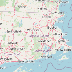
Map view of Boston Harbor Islands National and State Park

Use this park location map to pinpoint Boston Harbor Islands National and State Park in United States of America, understand its exact geographic position, and read its mapped placement within the surrounding landscape more clearly.

Pigeon | © OpenStreetMap contributors

Location context for Boston Harbor Islands National and State Park

Massachusetts

Visualizing coastal terrain, maritime scenery, and urban island habitats

Boston Harbor Islands National and State Park Photos and Landscapes

Visual documentation captures the varied coastal terrain, maritime architecture, and sheltered salt marshes defining Boston Harbor Islands National and State Park. Examining these protected area photographs reveals how urban harbor geography and recovering natural ecosystems intersect across the Massachusetts coast.

A dirt and gravel path curves through coastal vegetation toward a pier and small building on the shoreline of a bay under a clear blue sky.

Park atlas

Compare regional coastal geography and surrounding protected areas in Massachusetts

Parks Near Boston Harbor Islands National and State Park and Protected Landscapes

Continue exploring nearby national parks and protected areas to compare regional coastal terrain and Atlantic island ecosystems. Broader protected-landscape browsing reveals connected habitats across the surrounding Massachusetts shoreline.
A horizontal watercolor painting showing a wide coastal estuary with gentle hills in the background, a winding body of water in the middle ground, and soft green trees and shrubs in the foreground.
Nature reserveNew Hampshire
About 82 km away#1 closest

North

Great Bay National Estuarine Research Reserve: Protected Coastal and Estuarine Geography

Regional tidal habitat and protected watershed in New Hampshire

Great Bay National Estuarine Research Reserve protects a vital coastal landscape characterized by broad tidal basins, fringing salt marshes, and inland woodlands. Located in southeastern New Hampshire, this nature reserve serves as an essential site for studying the intersection of freshwater and saltwater ecosystems, preserving a mosaic of land and water that illustrates the complex geography of the Atlantic coast.

Area
41.42 km²
Established
1989
Relief
Lowland
Climate
Temperate
Marine protected areaRhode Island
About 87 km away#2 closest

Southwest

Narragansett Bay National Estuarine Research Reserve: Island and Marine Protected Area Overview

A coastal research landscape in Rhode Island

Discover the geographic composition of the Narragansett Bay National Estuarine Research Reserve. This marine protected area spans the terrestrial and aquatic zones of three major islands within the Narragansett Bay system, providing a deep look at estuarine habitat conservation and regional island geography.

Area
15.9 km²
Established
1980
Relief
Lowland
Climate
Temperate
Watercolor painting of a lush green landscape featuring rolling hills in the distance, a meandering stream in the midground, and wetlands with cattails in the foreground.
Protected landscapeVermont
About 169 km away#3 closest

Northwest

Green Mountain National Forest: Mapped Geography and Protected Landscape Analysis

Examining the wilderness backbone of Vermont's mountainous terrain

Gain insight into the expansive boundaries of Green Mountain National Forest, an essential protected area spanning the Green Mountains of Vermont. This profile details the forest's composition, ranging from high-elevation spruce-fir zones to mixed hardwood slopes and extensive federal wilderness corridors, providing a foundational geographic understanding of this vital northeastern landscape.

Area
1,615.31 km²
Established
1932
Relief
Mountain
Climate
Temperate
Protected landscapeNew Hampshire
About 173 km away#4 closest

North

White Mountain National Forest: Protected Landscape Atlas and Geographic Boundary Context

Mapping the alpine ridges and river valleys of New Hampshire

Delve into the geography of White Mountain National Forest, a primary federal protected landscape in the eastern United States. This overview details the mountainous terrain, including the Presidential Range and Pemigewasset Wilderness, providing a clear window into its spatial scale, watershed boundaries, and regional prominence within the New England landscape.

Area
3,038.59 km²
Established
1918
Relief
Mountain
Climate
Temperate
Wildlife reserveBennington County
About 179 km away#5 closest

West

George D. Aiken Wilderness: Protected Forest Landscapes and Ridgelines in Vermont

Detailed geographic overview of a Green Mountain wilderness reserve

Spanning over 4,800 acres in Bennington County, the George D. Aiken Wilderness stands as a significant protected area within the southern Green Mountains. The terrain features narrow ridgelines, steep valleys, and a dense canopy of northern hardwoods that remain unmanaged to maintain wilderness standards. This area serves as a primary geographic anchor for Eastern wilderness preservation efforts in the United States.

Area
19 km²
Established
1984
IUCN
Ib
Relief
Mountain
A horizontal watercolor painting depicting a winding river flowing through a lush, forested valley with rolling hills in the background.
Wildlife reserveVermont
About 185 km away#6 closest

Northwest

Lye Brook Wilderness: Protected High Plateau and Forest Geography in Southern Vermont

Mapped wilderness boundaries within the Green Mountain National Forest

Spanning nearly 18,000 acres, Lye Brook Wilderness offers a deep dive into southern Vermont's natural geography. The area features a high forested plateau, complex brook valleys, and elevated ridgelines that characterize this established wilderness reserve. Ideal for those studying the regional landscape and its protected ecosystem, this record provides essential context on the forest cover, glacial terrain, and the geographic significance of this Vermont backcountry unit.

Area
73.34 km²
Established
1975
IUCN
Ib
Protected landscapeVermont
About 200 km away#7 closest

Northwest

Robert T. Stafford White Rocks National Recreation Area: Protected Landscape and Regional Geography

Southern Vermont wilderness, quartzite formations, and Appalachian Trail corridors.

Robert T. Stafford White Rocks National Recreation Area represents a unique fusion of protected forest and rugged geological character in southern Vermont. Known for the quartzite rockslides of Chaos Canyon and its inclusion of two distinct wilderness areas, this territory offers a complex terrain profile. Spanning over 36,000 acres, it serves as a central hub for regional backcountry exploration, blending dense hardwood ecosystems with the prominent rocky outcrops that define its distinct mountainous identity.

Area
147 km²
Established
1984
Water
Major water bodies
Protected landscapeNew York
About 228 km away#8 closest

Southwest

Fire Island National Seashore: Geography and Protected Area Exploration

Barrier island ecosystems and coastal wilderness in New York

Fire Island National Seashore spans a narrow, thirty-mile barrier island corridor, protecting a mosaic of maritime pine forest, expansive Atlantic beaches, and quiet bay-side salt marshes. This protected landscape includes the Otis Pike Fire Island High Dune Wilderness and the maritime holly canopy of the Sunken Forest, offering an essential reference for exploring coastal geography in New York.

Area
79.23 km²
Established
1964
IUCN
V
Visitors
393.7K annual

Common questions about visiting, size, designation, and location context for Boston Harbor Islands National and State Park

Boston Harbor Islands National and State Park FAQs for park facts, access, geography, and protected area context

Find quick answers about Boston Harbor Islands National and State Park, including protected-area facts, park geography, trail and visitor context, and how the park fits into its surrounding country and regional landscape.
MoriAtlas Explorer

Continue Your Protected Areas Search Across the Global Atlas

Deepen your exploration by continuing the structured search for national parks and protected areas worldwide. Utilize the comprehensive filtering capabilities to compare different conservation landscapes and refine your understanding of global park geography. Discover more about the distribution and characteristics of protected natural areas.

Global natural geography