
Mori Atlas logo
Nature reserveBrackenbruch bei Hergershausen

Mapping the natural geography and wetland mosaic along the Lache stream

Brackenbruch bei Hergershausen: A Protected Floodplain Landscape in Landkreis Darmstadt-Dieburg

(Naturschutzgebiet „Brackenbruch bei Hergershausen”)

Brackenbruch bei Hergershausen represents a significant nature reserve within the Untermainebene region of southern Hesse. This protected floodplain landscape features a dynamic mosaic of regularly inundated meadows, shallow standing waters, and reed beds along the Lache stream. Managed to sustain oak-hornbeam forest development, the reserve serves as a vital ecological corridor embedded within the broader Natura 2000 network.

nature reservefloodplainwet meadowsreed bedsshallow watersoak-hornbeam forest
An illustration of a tranquil river winding through a grassy valley surrounded by forests, tall cliffs, and pink-toned sunset clouds.

Brackenbruch bei Hergershausen

Nature reserve

Park overview

Structured park overview, official facts, and landscape profile for Brackenbruch bei Hergershausen

Brackenbruch bei Hergershausen park facts, protected area profile, and essential visitor context

Review the core facts for Brackenbruch bei Hergershausen, including designation, size, terrain, visitor scale, habitats, and operating context in one park-focused overview.

About Brackenbruch bei Hergershausen

Brackenbruch bei Hergershausen is one of many smaller nature reserves within the Darmstadt-Dieburg district in southern Hesse, but it stands out for its clear focus on floodplain ecology. The reserve lies in the Untermainebene natural region, in the Gersprenzniederung subunit defined by the course of the Gersprenz river and its tributary the Lache. At roughly 52 hectares, the area is compact, yet it captures many of the structural elements that characterize traditional lowland floodplain landscapes: shallow standing waters, wet meadows that are seasonally inundated by the Lache, reed and sedge stands, fallow wet scrub, and adjoining forest.

The reserve was established by decree on 25 October 1999 with the explicit goal of preserving a characteristic, regularly flooded floodplain area with diverse water body types, extensively used wet grassland, wet fallow land, and adjacent forest stands in various stages of succession. These habitats collectively provide refuge for many threatened species of plants and animals that depend on the dynamic interplay of water, meadow, and woodland.

A central part of the reserve's identity is its connection to larger European conservation efforts. Since 2008, the reserve has been integrated into the Natura 2000 network, both as part of the Untere Gersprenz site under the EU Habitats Directive and as the Hergershausen sub-area of the Untere Gersprenzaue site under the EU Birds Directive. This dual designation reflects the area's importance not only for general floodplain biodiversity but also for bird species of European conservation concern.

Quick facts and research context for Brackenbruch bei Hergershausen

Brackenbruch bei Hergershausen is a nature reserve in the Darmstadt-Dieburg district of southern Hesse, Germany, located between the villages of Sickenhofen and Hergershausen near Babenhausen. The reserve lies in the Untermainebene natural region within the Gersprenz lowland and extends along the Lache stream.

Designated by official decree on 25 October 1999, the protected area covers approximately 52 hectares of floodplain meadows, shallow waters, reed beds, and mixed forest. It forms part of the Natura 2000 network, integrated into both the Untere Gersprenz Habitats Directive site and the Untere Gersprenzaue Birds Directive site.

Protection and recognition

Documented protection history, management scope, and verified registry data

Brackenbruch bei Hergershausen Protection Status and Designated Area Records

Brackenbruch bei Hergershausen maintains official protected area records and designated status details sourced directly from global conservation databases. Verified registry entries outline the official designation framework and international recognition context associated with the protected landscape.

Protection details

WDPA ID
318227
Park context

Deeper park guide and search-rich context for Brackenbruch bei Hergershausen

Brackenbruch bei Hergershausen history, landscape, wildlife, and travel context

Explore Brackenbruch bei Hergershausen through its history, landscape character, ecosystems, wildlife, conservation priorities, cultural context, and seasonal travel timing in a structured park guide built for atlas discovery and search intent.

Why Brackenbruch bei Hergershausen stands out

The reserve is best known for preserving a small but ecologically rich floodplain mosaic, where regularly inundated meadows, shallow standing water bodies, reed beds, and patches of near-natural forest occur side by side. Its location along the Lache stream makes it a representative example of the southern Hessian lowland floodplain ecosystems that have become increasingly rare in the intensively farmed Rhine-Main region. Management aims at maintaining extensive meadow use and developing the woodland toward a site-typical oak-hornbeam forest, while leaving certain areas unmanaged to serve as habitat for species associated with old-growth and decay-phase woodland.
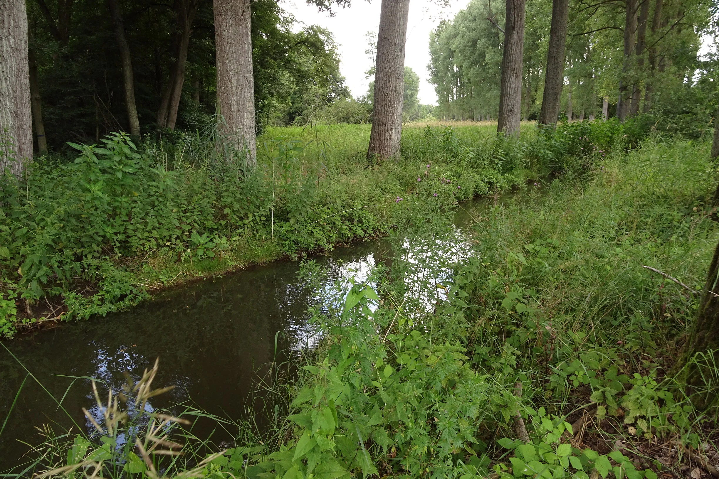
A small, quiet stream flows through a lush green floodplain area bordered by tall trees and dense vegetation.
The Lache stream flowing through the landscape of the Brackenbruch bei Hergershausen nature reserve.

Brackenbruch bei Hergershausen history and protected-area timeline

The history of Brackenbruch bei Hergershausen as a protected area is relatively recent, beginning with its formal designation as a Naturschutzgebiet on 25 October 1999. The decree recognized the value of an existing floodplain landscape that, despite its small size, retained much of the structural character of the traditional southern Hessian river lowlands, including extensive wet meadows, shallow waters, and accompanying woodland.

Following its initial protection, the reserve gained wider ecological significance in 2008 when it became integrated into the Natura 2000 network as part of the Untere Gersprenz site designated under the EU Habitats Directive, with a further update in 2016. It is also recognized as the Hergershausen sub-area of the Untere Gersprenzaue EU Birds Directive site, linking local Hessian conservation efforts to broader European biodiversity policy.

Management planning has emphasized a combination of extensive grassland use and close-to-nature forestry, with the explicit aim of allowing parts of the forest to develop toward a site-typical oak-hornbeam forest and leaving selected areas unmanaged to support species associated with woodland decay and natural structural diversity.

Brackenbruch bei Hergershausen landscape and geographic character

The landscape of Brackenbruch bei Hergershausen is shaped by the gentle topography of the Untermainebene and the hydrology of the small Lache stream, which runs along the western edge of the reserve. The terrain is largely flat to very gently undulating, typical of the southern Hessian lowland between the Main and the northern edge of the Odenwald. The Lache's seasonal flooding creates a dynamic floodplain mosaic at the heart of the reserve.

Visible landscape elements include open wet meadows with shallow standing waters, reed and sedge beds, wet fallow land transitioning into scrub, and adjoining taller woodland. The combination of open water, marsh vegetation, and forest edge creates a varied mosaic that shifts visually with the seasons, especially during the wet periods when the meadows turn into temporary shallow lakes. Forest patches within the reserve reflect the intention to develop them toward a site-typical oak-hornbeam forest, characteristic of the region's potential natural vegetation.
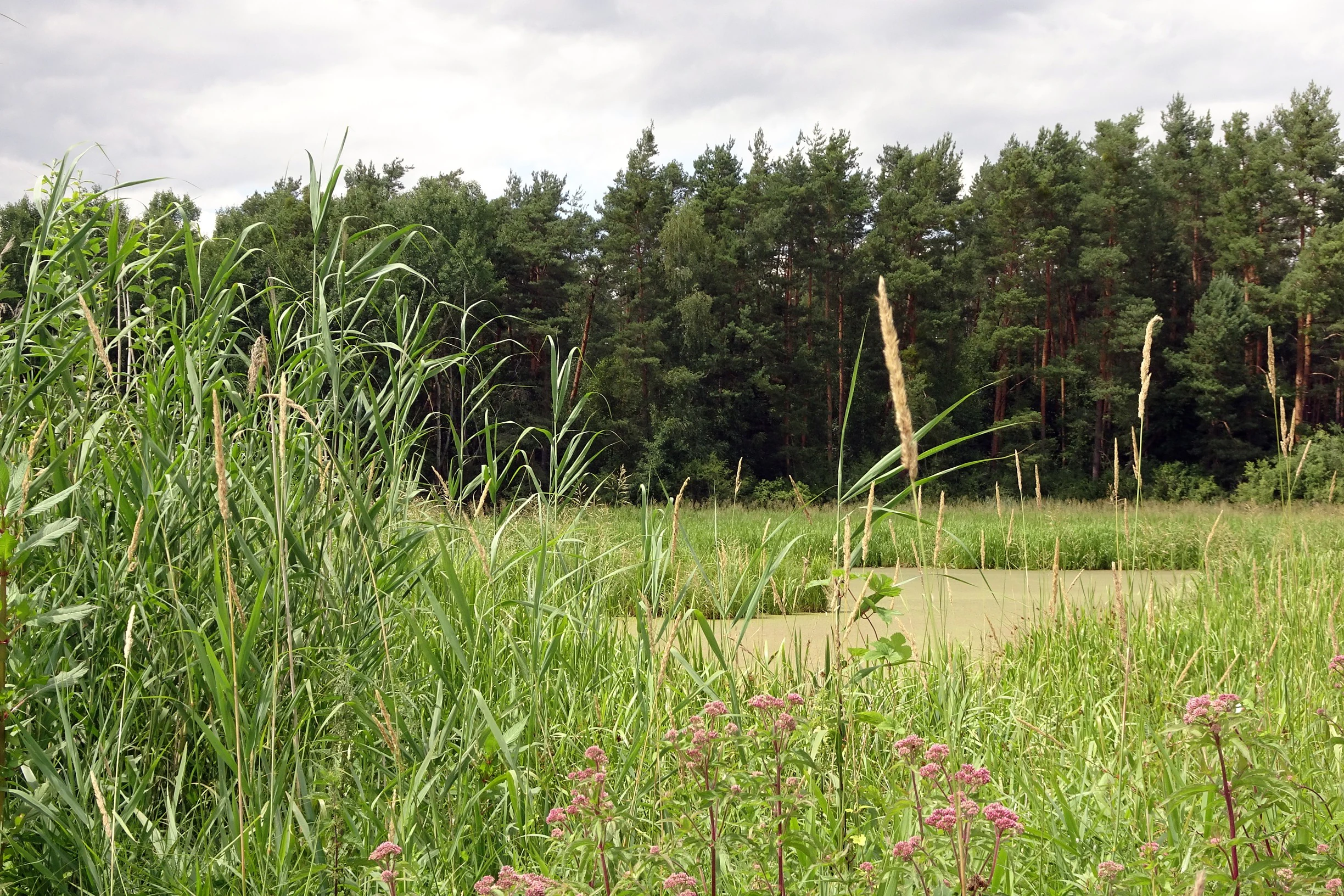
A wetland area with tall reeds and wildflowers in the foreground, leading to a calm pool of water, with a dense coniferous forest in the background under a cloudy sky.
A view of the wetland and forest edge within the Brackenbruch bei Hergershausen nature reserve.

Brackenbruch bei Hergershausen ecosystems, habitats, and plant life

Ecologically, Brackenbruch bei Hergershausen is defined by the interplay of open water, wet grassland, and woodland, producing a habitat mosaic with high ecological value per unit area. The regularly flooded meadows and shallow standing waters support reed and sedge communities, while the wet fallow land provides transitional habitats for species that benefit from a mix of open and encroaching vegetation.

The adjoining forest represents the second pillar of the reserve's ecological character. Management aims at close-to-nature forestry with development toward a standorttypischen Stieleichen-Hainbuchen-Wald, a pedunculate oak and hornbeam forest typical of the region's loamy soils. Notably, parts of the forest are deliberately left unmanaged to provide habitat for species associated with decay and old-growth conditions.

The combination of floodplain dynamics, extensive grassland use, and near-natural forest management positions the reserve as a representative example of lowland floodplain ecosystems in the Rhine-Main area, an ecological context that has been heavily diminished by intensive agriculture and settlement in surrounding regions.

Brackenbruch bei Hergershausen conservation status and protection priorities

From a conservation perspective, Brackenbruch bei Hergershausen is significant primarily as a small but well-structured refuge for floodplain-associated species in a region where such habitats have become fragmented by agriculture and development. The reserve's designation as a Naturschutzgebiet in 1999 was specifically intended to protect a regularly flooded floodplain area with diverse water body types, extensively used wet grassland, wet fallow land, and adjacent forest, recognized as habitat for numerous threatened plant and animal species.

Management objectives explicitly combine extensive meadow use with close-to-nature forestry, aiming to maintain habitat diversity and develop the forest toward a site-typical oak-hornbeam community while leaving selected areas to progress naturally for the benefit of species tied to decay and structural complexity. The reserve's inclusion, since 2008, in the Natura 2000 network as part of both the Untere Gersprenz FFH site and the Untere Gersprenzaue EU Birds Directive site further underlines its role in maintaining habitats and bird populations of European conservation interest.

Top sights and standout views in Brackenbruch bei Hergershausen

The reserve's highlights center on its compact but representative floodplain mosaic, anchored along the Lache stream within the larger Gersprenz lowland. Notable features include the regularly inundated meadows, reed and sedge beds, shallow standing waters, and adjoining forest stands managed toward oak-hornbeam woodland.

Its integration into the Natura 2000 network, both under the Habitats Directive and the Birds Directive, places the small local reserve within a broader framework of European nature conservation, strengthening its significance beyond its modest footprint.

Best time to visit Brackenbruch bei Hergershausen

As a small lowland floodplain reserve, Brackenbruch bei Hergershausen offers different impressions throughout the year. Spring and early summer are typically the most rewarding seasons for observing the wet meadows in full vegetation growth, with shallow waters attracting waterfowl and the reed beds becoming most active with birdsong.

Late autumn and winter often reveal the hydrological character of the site more clearly, as the Lache stream and floodplain meadows expand into broader wet areas, while the deciduous forest sections lose their leaf cover and make woodland structure easier to appreciate. Summer visits offer lush greenery but also bring more insect activity, especially around the reed beds and water bodies.

Monthly climate preview

Long-term representative point measurements tracking monthly averages and precipitation patterns.

Brackenbruch bei Hergershausen Climate Normals and Annual Temperature Rhythm

Representative coordinate measurements document measured long-term temperature swings alongside steady daily precipitation rates across the annual cycle for Brackenbruch bei Hergershausen. Analyzing the full twelve-month statistical profile clarifies how monthly temperature extremes and precipitation averages develop over time.
Annual mean10 °C
0 °C21 °C
Jan
Feb
Mar
Apr10°
May14°
Jun18°
Jul21°
Aug20°
Sep15°
Oct10°
Nov
Dec
Warmest month
July

20.6 °C

Coolest month
January

0.2 °C

Wettest month
July

2.2 mm/day

Driest month
April

1.4 mm/day

Park location guide

Geography guide, regional context, and park location map for Brackenbruch bei Hergershausen

Brackenbruch bei Hergershausen park geography, regions, and map view in Germany

Understand where Brackenbruch bei Hergershausen sits in Germany through a broader geographic reading of the surrounding landscape, nearby location context, and its mapped position within the national park landscape.

How Brackenbruch bei Hergershausen fits into Germany

Germany is a federal republic in Western and Central Europe with a population of over 83 million across sixteen constituent states. It is Europe's largest economy by nominal GDP and a major global exporter and importer. The capital is Berlin, and the country borders Denmark, Poland, Czech Republic, Austria, Switzerland, France, Luxembourg, Belgium, and the Netherlands.

Wider geography shaping Brackenbruch bei Hergershausen in Germany

Germany is located in Western and Central Europe, spanning 357,022 km². It borders Denmark to the north, Poland and the Czech Republic to the east, Austria and Switzerland to the south, and France, Luxembourg, Belgium, and the Netherlands to the west. The country has coastlines on the Baltic Sea and North Sea to the north, with the Alps located in the southern region.

Map view of Brackenbruch bei Hergershausen

Use this park location map to pinpoint Brackenbruch bei Hergershausen in Germany, understand its exact geographic position, and read its mapped placement within the surrounding landscape more clearly.

Pigeon | © OpenStreetMap contributors

Location context for Brackenbruch bei Hergershausen

HessenLandkreis Darmstadt-Dieburg

Visual reference of floodplain habitats, wet meadows, and protected terrain

Brackenbruch bei Hergershausen Photos and Landscape Scenery

Visual records reveal the diverse floodplain mosaic and seasonal wetland habitats defining Brackenbruch bei Hergershausen. Photographic documentation captures the flat lowland terrain, shallow standing waters, and protected vegetation patterns across the reserve.

A small, quiet stream flows through a lush green floodplain area bordered by tall trees and dense vegetation.

A wide view of a grassy wetland area with tall reeds in the foreground and a line of deciduous trees in the background under a cloudy sky.

A wetland area with tall reeds and wildflowers in the foreground, leading to a calm pool of water, with a dense coniferous forest in the background under a cloudy sky.

Park atlas

Discover surrounding Hessian lowland nature reserves and connected floodplain habitats.

Parks Near Brackenbruch bei Hergershausen and Regional Protected Landscapes to Compare

Compare Brackenbruch bei Hergershausen with other protected areas located across the surrounding southern Hessian river valleys. Examining adjacent lowland ecosystems provides broader geographic context for regional wetland conservation.
A soft watercolor painting showing a tranquil wetland landscape with calm water, grassy shores, and hazy mountains in the background.
Nature reserveHessen
About 2 km away#1 closest

North

Kies- und Sandgrube von Dudenhofen: Regional Nature Reserve and Wetland Mapping

Protected post-extraction landscape in the Hessen region

Kies- und Sandgrube von Dudenhofen protects a distinct network of shallow-water habitats and open-ground terrain near Rodgau. Managed as a nature reserve, this area serves as an essential regional hub for wetland biodiversity, mapping the transition between industrial remnants and regenerated forest ecosystems within the Rhine-Main lowlands.

Area
0.173 km²
Established
1995
IUCN
IV
A soft watercolor illustration depicting a meadow landscape with a winding stream, distant hills, and foreground wildflowers.
Nature reserveHessen
About 2.6 km away#2 closest

Southwest

Die kleine Qualle von Hergershausen Nature Reserve and Protected Floodplain Landscapes

A preserved wetland fragment in the Hessen region

Die kleine Qualle von Hergershausen stands as a key protected area within the Gersprenz floodplain. This site offers a unique look at remnant wet meadow terrain, serving as an essential breeding and stopover ground for waterbirds in the Darmstadt-Dieburg district. Its geography provides a clear contrast to the surrounding agricultural fields, highlighting the impact of long-term conservation and habitat restoration efforts.

Area
0.27 km²
Established
1984
IUCN
IV
A horizontal watercolor painting depicting a soft-focus landscape with green fields, patches of wildflowers, and distant low hills.
Nature reserveHessen
About 2.7 km away#3 closest

South

Auf dem Sand zwischen Hergershausen und Altheim Protected Nature Reserve in Hessen

Inland dune and floodplain landscape mapping

Explore the geography of Auf dem Sand zwischen Hergershausen und Altheim, a nature reserve in Hessen. The area serves as a critical habitat mosaic, featuring sandy inland dunes, expansive wet grasslands, and renaturalized floodplain terrain within the Gersprenz valley.

Area
0.233 km²
Established
1998
IUCN
IV
Nature reserveLandkreis Offenbach
About 3.2 km away#4 closest

Northwest

Niederrodener Lache: A Protected Nature Reserve in Landkreis Offenbach, Germany

Brook-side habitat mosaic and regional landscape geography

Niederrodener Lache encompasses 124 hectares of protected woodland and grassland in the Landkreis Offenbach district. Centered on the Lache brook, the reserve hosts a dense interweaving of alder-fringed streams and varied meadow types. Its landscape profile provides a vital refuge for threatened vegetation and wetland biotopes within the suburbanizing Rhine-Main metropolitan area.

Area
1.246 km²
Established
1986
IUCN
IV
A soft watercolor painting of a winding stream through a green wetland with trees and distant hills in the background.
Nature reserveHessen
About 5.1 km away#5 closest

Southwest

Faulbruch von Münster Nature Reserve: Hessen Wetland and Forest Geography

Mapped protected landscapes in southern Germany.

Discover the geographic composition of Faulbruch von Münster, a protected nature reserve in Hessen. This area features a distinctive mix of alder swamp forest and wet meadows, providing a valuable habitat within the Rhine-Main region. Analyze the terrain, forest patches, and wetland boundaries through our detailed regional atlas.

Area
0.77 km²
Established
1985
IUCN
IV
Nature reserveHessen
About 5.5 km away#6 closest

Northeast

Mooskiefernwald von Dudenhofen: Mapped Nature Reserve and Protected Pine Woodland in Hessen

Regional landscape context and protected area boundaries

Study the geographic composition of Mooskiefernwald von Dudenhofen, a specialized nature reserve in Hessen. This 36-hectare site features a rare moss-pine woodland environment and sandy soil habitats, offering a distinct contrast to the industrial and suburban landscape of the Rodgau area.

Area
0.361 km²
Established
1999
IUCN
IV
A watercolor painting of a flat, marshy landscape with soft green trees, grassy plains, and subtle pink tones against a white background.
Nature reserveHessen
About 5.5 km away#7 closest

Northwest

Rodauwiesen bei Rollwald Nature Reserve: Protected Lowland Landscapes in Hessen

Mapping floodplain meadows and reed habitats in the Rodau valley

The Rodauwiesen bei Rollwald nature reserve protects a distinct 32-hectare stretch of lowland floodplain along the Rodau stream in Hessen. This site serves as a vital green refuge, featuring expansive open grassland and significant common reed stands that mirror the historic character of the Untermainebene. Use this geographic reference to study the area's protected boundaries, hydrological terrain, and surviving wet meadow ecosystems within a rapidly developing urban corridor.

Area
0.327 km²
Established
1999
IUCN
IV
Relief
Lowland
A soft watercolor illustration depicting a calm wetland scene with distant rolling hills, foreground reeds, and overhanging tree branches.
Nature reserveHesse
About 5.6 km away#8 closest

West

Rallenteich von Eppertshausen Nature Reserve: Protected Landscape and Regional Geography

Wetland and forest mosaic in the Hesse region

Examine the geographic footprint of Rallenteich von Eppertshausen, a significant nature reserve in Hesse, Germany. This 12-hectare protected area showcases a dense mosaic of pond, reedbed, and acidic oak forest that evolved from historical clay mining. Understanding the park's topography and internal landscape zones offers insight into the evolution of post-industrial protected lands.

Area
0.12 km²
Established
1976
IUCN
IV
Relief
Lowland

Common questions about visiting, size, designation, and location context for Brackenbruch bei Hergershausen

Brackenbruch bei Hergershausen FAQs for park facts, access, geography, and protected area context

Find quick answers about Brackenbruch bei Hergershausen, including protected-area facts, park geography, trail and visitor context, and how the park fits into its surrounding country and regional landscape.
MoriAtlas Explorer

Continue Your Protected Areas Search Across the Global Atlas

Deepen your exploration by continuing the structured search for national parks and protected areas worldwide. Utilize the comprehensive filtering capabilities to compare different conservation landscapes and refine your understanding of global park geography. Discover more about the distribution and characteristics of protected natural areas.

Global natural geography