

Mori Atlas logo
Wildlife reserveBura Chapori Wildlife Sanctuary

Examining the floodplain grasslands and riverine ecosystems of this vital Brahmaputra buffer zone.

Bura Chapori Wildlife Sanctuary: Mapped Landscapes and Protected Geography in Assam, India

Bura Chapori Wildlife Sanctuary represents a crucial protected landscape along the southern banks of the Brahmaputra River in Assam, India. This sanctuary serves as a key grassland ecosystem and a notified buffer for the nearby Kaziranga Tiger Reserve, maintaining an essential corridor for wildlife movement. Through its mosaic of floodplain grasslands, seasonal wetlands, and riverine woodlands, the area provides a sanctuary for diverse mammal populations and threatened bird species within the larger Brahmaputra valley terrain.

Brahmaputra floodplaingrassland sanctuarywildlife sanctuaryIndiaAssambuffer to Kaziranga

Bura Chapori Wildlife Sanctuary

Wildlife reserve

Park overview

Structured park overview, official facts, and landscape profile for Bura Chapori Wildlife Sanctuary

Bura Chapori Wildlife Sanctuary park facts, protected area profile, and essential visitor context

Review the core facts for Bura Chapori Wildlife Sanctuary, including designation, size, terrain, visitor scale, habitats, and operating context in one park-focused overview.

About Bura Chapori Wildlife Sanctuary

Bura Chapori Wildlife Sanctuary lies within the upper Brahmaputra floodplain in Assam, a region shaped by the great river's seasonal flooding and long history of dynamic land use. The sanctuary occupies a strip of grassland and associated woodland close to the river's southern bank, within the Sonitpur district. Because of its compact size and direct connection with the broader floodplain, the park plays an important role in conservation beyond its own borders.

Ecologically, Bura Chapori is a textbook example of a Brahmaputra valley grassland sanctuary. The landscape is dominated by open expanses of tall grassland, interspersed with patches of woodland, wetlands, and water bodies that fill with water during the monsoon. This combination of habitats supports a mix of grassland-dependent birds, large floodplain mammals, reptiles, and resident and migratory waterbirds. The sanctuary's location alongside the Brahmaputra, and its role as part of the Laokhowa-Burachapori ecosystem, place it within a wider network of floodplain reserves that allow wildlife to move and respond to seasonal flooding patterns.

Bura Chapori is often discussed in the context of conservation of the Bengal florican, a critically threatened bird that requires large areas of undisturbed grassland for breeding. The sanctuary's open habitat and relatively low levels of dense forest cover make it particularly valuable for florican conservation. At the same time, the same landscape supports populations of Indian rhinoceros, wild buffalo, and other large mammals typical of Assam's floodplain ecosystem. The sanctuary's position as a notified buffer to the Kaziranga Tiger Reserve further increases its importance to long-term rhino and tiger conservation across the region.

Quick facts and research context for Bura Chapori Wildlife Sanctuary

Bura Chapori Wildlife Sanctuary is a small protected area in Assam, India, located on the south bank of the Brahmaputra River in Sonitpur district. It covers approximately 44 square kilometers of floodplain habitat and lies near Tezpur. The sanctuary was first declared a reserved forest in 1974 and received wildlife sanctuary status in 1995. It functions as a notified buffer of the Kaziranga Tiger Reserve and is part of the broader Laokhowa-Burachapori ecosystem managed by the Assam Department of Environment and Forests. Its grassland landscape supports significant populations of Bengal florican and Indian rhinoceros, along with a wide range of other wildlife species.

Protection and recognition

Documented terrestrial protection history and management scope details

Bura Chapori Wildlife Sanctuary Protection Status and Designation Records

Bura Chapori Wildlife Sanctuary maintains a documented terrestrial protection status established in 1995. Official records outline the verified designation history and administrative scope without external international recognition sources.

Protection details

Protection scope
Terrestrial
Designated year
1995
Transboundary protection
No
Park context

Deeper park guide and search-rich context for Bura Chapori Wildlife Sanctuary

Bura Chapori Wildlife Sanctuary history, landscape, wildlife, and travel context

Explore Bura Chapori Wildlife Sanctuary through its history, landscape character, ecosystems, wildlife, conservation priorities, cultural context, and seasonal travel timing in a structured park guide built for atlas discovery and search intent.

Why Bura Chapori Wildlife Sanctuary stands out

Bura Chapori is best known for its importance to the Bengal florican, a globally threatened grassland bird that depends on the open floodplain habitat maintained within the sanctuary. Few protected areas in India are specifically associated with such strong florican conservation focus, and the sanctuary's open terrain and seasonal wetlands make it especially valuable for this species. Alongside its birdlife, Bura Chapori is recognized for its role in protecting floodplain mammal populations, particularly Indian rhinoceros, wild buffalo, and tiger. The sanctuary is also valued as a notified buffer to Kaziranga Tiger Reserve, allowing wildlife to move between the two protected complexes along the Brahmaputra floodplain.
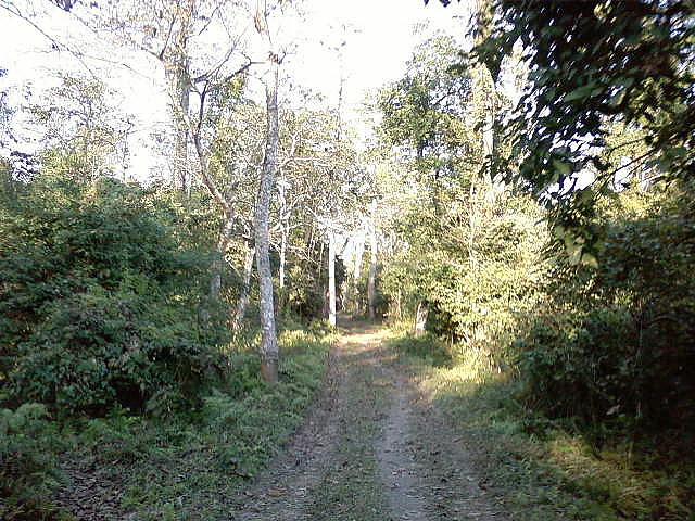
A narrow dirt track leads through a dense, green forest in Bura Chapori Wildlife Sanctuary with tall trees and leafy undergrowth on both sides.
A narrow dirt path winding through the dense vegetation of Bura Chapori Wildlife Sanctuary.

Bura Chapori Wildlife Sanctuary history and protected-area timeline

The landscape that today forms Bura Chapori Wildlife Sanctuary was first brought under formal protection in 1974, when it was declared a reserved forest under the Assam Forest Department. At that stage, the area was primarily recognized for its resource value rather than as a designated wildlife conservation unit.

In 1995, the area was upgraded and officially notified as a wildlife sanctuary, marking a significant shift toward biodiversity conservation as a primary management objective. This status change placed the sanctuary within India's broader protected area framework and aligned it with the conservation priorities being implemented elsewhere in the Brahmaputra valley.

Over time, Bura Chapori has come to be regarded as an important component of the Laokhowa-Burachapori ecosystem and as a notified buffer to the Kaziranga Tiger Reserve. This integration reflects a wider conservation recognition that grassland habitats adjacent to Kaziranga are essential for the long-term viability of species such as the Indian rhinoceros, the Bengal florican, and the tiger.

Bura Chapori Wildlife Sanctuary landscape and geographic character

Bura Chapori occupies part of the Brahmaputra floodplain in northern Assam, a region characterized by low elevation, flat terrain, and wide seasonal shifts between dry and flooded states. The sanctuary's geography is closely tied to the behavior of the Brahmaputra River, with the river's southern bank forming a defining edge to the protected area.

The sanctuary itself is dominated by open grassland, with varying stretches of savannah-like terrain supporting tall grass species typical of the region. Within this grassland matrix, scattered patches of riverine woodland and tree cover occur along watercourses and slightly elevated ground. Wetland depressions and water bodies, often seasonal in character, dot the landscape and contribute to the habitat mosaic that supports both resident and migratory wildlife.

The terrain lacks dramatic relief, and the visual character of Bura Chapori is defined less by elevation than by the interplay between land, water, and grass. During the dry season, the open landscape dominates; during the monsoon, floodwater reshapes accessibility and visibility, turning much of the area into a wetland environment.

Bura Chapori Wildlife Sanctuary ecosystems, habitats, and plant life

The ecological identity of Bura Chapori is defined by its floodplain grassland ecosystems, which are among the most threatened and biodiverse habitat types in South Asia. The sanctuary supports a mosaic of grasslands, wetlands, and open woodland, all driven by the seasonal rhythm of the Brahmaputra River and the local climate.

Vegetation in the sanctuary is primarily tall grassland, with various grass species adapted to the alternating wet and dry conditions of the floodplain. Dispersed trees and scrub patches add structural diversity, while aquatic and semi-aquatic vegetation populates the sanctuary's wetlands and pools. This mixed habitat structure creates the conditions needed to support a wide range of species, particularly those that depend on open landscapes rather than dense forest.

From an ecological perspective, Bura Chapori belongs to the Indo-Burmese grassland system, and its habitats share much in common with those of nearby Kaziranga. These grasslands support unique breeding habitat for threatened bird species, foraging and movement corridors for large mammals, and seasonal habitat for migratory waterbirds. The continued availability of these habitats, despite significant pressures on floodplain environments elsewhere in Assam, gives the sanctuary strong ecological value.

Bura Chapori Wildlife Sanctuary wildlife and species highlights

The wildlife profile of Bura Chapori is shaped by its open grassland character and connection to the wider Brahmaputra floodplain. The sanctuary is widely recognized for its importance to the Bengal florican, a globally endangered bird that depends heavily on extensive, undisturbed grassland. Bura Chapori is considered an ideal habitat for this species and supports its year-round presence during the appropriate seasons.

The sanctuary also supports significant populations of large mammals typical of the Brahmaputra valley. Indian rhinoceros are present, along with wild buffalo, tiger, leopard, hog deer, and wild pig. From time to time, herds of elephants move through the area, extending their range from neighboring protected landscapes. Reptiles and freshwater fish are also documented within the sanctuary's habitats.

The birdlife at Bura Chapori extends well beyond the Bengal florican. The wetlands and open waters of the sanctuary attract a variety of migratory waterbirds, including black-necked stork, openbill stork, mallard, teal, and whistling duck, along with other species not always individually named in basic records. The combination of resident grassland species and seasonal migratory visitors makes the sanctuary an important site for birdwatching within the Brahmaputra valley.

Bura Chapori Wildlife Sanctuary conservation status and protection priorities

From a conservation perspective, Bura Chapori holds importance that extends beyond its modest size. Its designation as a notified buffer to the Kaziranga Tiger Reserve reflects the understanding that small protected areas adjacent to Kaziranga can play a critical role in maintaining habitat connectivity, supporting species that range widely across the floodplain. The sanctuary helps extend the effective conservation landscape of the upper Brahmaputra valley.

The sanctuary is particularly significant for the conservation of the Bengal florican, one of the most threatened bird species in South Asia. By preserving an area of undisturbed floodplain grassland, Bura Chapori provides a refuge for florican populations and helps maintain breeding habitat that has been lost in many other parts of the species' range. The protected status of the area is an important safeguard against habitat conversion, which has been a major driver of florican decline.

Bura Chapori also contributes to conservation of large floodplain mammals, particularly Indian rhinoceros and tiger. As part of the Laokhowa-Burachapori ecosystem, the sanctuary supports wildlife movement and population dynamics that are critical for the long-term viability of these species. The protected area is managed by the Department of Environment and Forests, Government of Assam, and benefits from integration with broader regional conservation strategies aimed at preserving the integrity of the Brahmaputra floodplain ecosystem.

Top sights and standout views in Bura Chapori Wildlife Sanctuary

Bura Chapori Wildlife Sanctuary stands out for its combination of compact area size and remarkable ecological concentration. Its open floodplain grasslands are among the most important habitats in Northeast India for the Bengal florican, while its floodplain mammal community links directly to the larger populations found in Kaziranga National Park. The sanctuary's role as a notified buffer to the Kaziranga Tiger Reserve elevates its conservation significance beyond its own boundaries.

The mix of large mammals, endangered grassland birds, reptiles, and migratory waterbirds gives Bura Chapori a distinctive wildlife profile. For visitors interested in the upper Brahmaputra floodplain, the sanctuary offers a focused, grassland-centered experience that complements the broader, more widely known Kaziranga landscape.

Best time to visit Bura Chapori Wildlife Sanctuary

The most comfortable period for a visit to Bura Chapori generally falls within the dry, cooler season, when the grasslands are accessible and floodwaters have receded. This period offers better wildlife visibility across open terrain, and seasonal wetlands can still attract good populations of waterbirds without restricting movement.

During the monsoon, much of the sanctuary becomes flooded or difficult to access, and visibility is reduced by tall grass growth and high water levels. Wildlife observation can become more challenging, although the landscape takes on a deeply seasonal character. Visitors oriented to migratory waterbirds may find the cooler months especially rewarding, while those specifically interested in the Bengal florican typically benefit from periods when grass height is moderate rather than at its annual peak.

Monthly climate preview

Long-term monthly temperature and precipitation rhythm for Assam protected areas

Bura Chapori Wildlife Sanctuary Climate Normals and Annual Temperature Patterns

Bura Chapori Wildlife Sanctuary exhibits measured monthly variations in long-term temperature and precipitation norms based on representative coordinate data. Examining the complete twelve-month climatology profile reveals comprehensive variations across temperature and precipitation cycles.
Annual mean24 °C
16 °C29 °C
Jan16°
Feb19°
Mar23°
Apr27°
May28°
Jun29°
Jul29°
Aug29°
Sep28°
Oct25°
Nov21°
Dec17°
Warmest month
June

29.1 °C

Coolest month
January

15.9 °C

Wettest month
June

9.5 mm/day

Driest month
December

0.3 mm/day

Park location guide

Geography guide, regional context, and park location map for Bura Chapori Wildlife Sanctuary

Bura Chapori Wildlife Sanctuary park geography, regions, and map view in India

Understand where Bura Chapori Wildlife Sanctuary sits in India through a broader geographic reading of the surrounding landscape, nearby location context, and its mapped position within the national park landscape.

How Bura Chapori Wildlife Sanctuary fits into India

India is a South Asian country bordered by the Indian Ocean, Arabian Sea, and Bay of Bengal. It shares land borders with Pakistan, China, Nepal, Bhutan, Bangladesh, and Myanmar. The country has a population of over 1.4 billion people and operates as a federal parliamentary republic with its capital in New Delhi.

Wider geography shaping Bura Chapori Wildlife Sanctuary in India

India occupies the Indian subcontinent in South Asia, bordered by the Arabian Sea to the southwest, the Bay of Bengal to the southeast, and the Indian Ocean to the south. It shares land borders with Pakistan to the west, China, Nepal, and Bhutan to the north, and Bangladesh and Myanmar to the east. The territory also includes the Andaman and Nicobar Islands in the Indian Ocean.

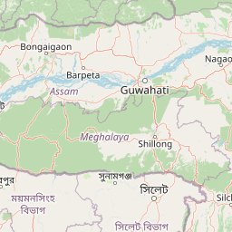
Map view of Bura Chapori Wildlife Sanctuary

Use this park location map to pinpoint Bura Chapori Wildlife Sanctuary in India, understand its exact geographic position, and read its mapped placement within the surrounding landscape more clearly.

Pigeon | © OpenStreetMap contributors

Location context for Bura Chapori Wildlife Sanctuary

Assam

Visual reference of floodplain grasslands, riverine habitats, and terrain across Assam

Bura Chapori Wildlife Sanctuary Photos, Landscapes, and Protected Scenery

Browse detailed photography capturing the open floodplain grasslands, riverine woodlands, and seasonal wetland habitats of Bura Chapori Wildlife Sanctuary. Visual records reveal the flat terrain and distinct environmental character of this protected Assam reserve along the Brahmaputra River.

A narrow dirt track leads through a dense, green forest in Bura Chapori Wildlife Sanctuary with tall trees and leafy undergrowth on both sides.

Park atlas

Compare adjacent floodplain protected areas across the surrounding region

Explore Parks Near Bura Chapori Wildlife Sanctuary and Connected Regional Reserves

Browse nearby national parks and connected protected landscapes linked to the surrounding valley ecosystem. Expanding geographic comparison helps place regional floodplain habitats and wildlife reserves into a wider conservation context.
Watercolor painting of green hills, fields, and a body of water
National parkAssam
About 32 km away#1 closest

East

Kaziranga National Park National Park: Protected Landscape and Geographic Atlas

Mapped boundaries and regional landscape context for this Assam natural area.

Delve into the detailed geographic profile of Kaziranga National Park, a prominent National Park located in Assam, India. This section focuses on its mapped protected area extent, its unique landscape characteristics within the Brahmaputra valley, and its role as a key natural landmark in northeastern India's atlas. Understand the structured geographic data and protected land identity that makes Kaziranga National Park a distinct entity for exploration.

Area
1,090 km²
Established
1905
IUCN
II
Relief
Lowland
National parkAssam
About 37 km away#2 closest

West

Orang National Park: Assam's Key Floodplain Protected Landscape

Explore mapped boundaries and terrain context of this national park.

Orang National Park, located in Assam, India, is a significant protected area celebrated for its unique alluvial floodplain terrain and critical role in conservation. This national park provides a focused atlas-style view of grassland and wetland ecosystems, essential habitats for iconic species like the great Indian one-horned rhinoceros and Bengal tiger. Its geographical setting along the Brahmaputra River contributes to a dynamic landscape, offering rich context for understanding protected area distribution and regional natural features. Discover the mapped boundaries and ecological significance of this important protected land.

Area
78.81 km²
Established
1985
IUCN
II
Relief
Lowland
National parkSonitpur
About 56 km away#3 closest

North

Nameri National Park: A Protected Landscape within Sonitpur's Geography

Explore the mapped terrain and national park boundaries.

Nameri National Park represents a significant protected natural area, contributing to the regional geography of Sonitpur, India. This page offers an atlas-oriented perspective, detailing the park's mapped landscape and its designation as a national park. Understand the geographic context and the protected land's specific identity within this mapped region.

Area
200 km²
Established
1978
IUCN
II
Relief
Mountain
Wildlife reserveWest Kameng
About 71 km away#4 closest

Northwest

Eaglenest Wildlife Sanctuary: Geography and Protected Forest Atlas

Mapping the Eastern Himalayan foothills in West Kameng

Eaglenest Wildlife Sanctuary stands as a landmark of Indo-Burmese biodiversity conservation, spanning a dramatic altitudinal range that anchors the West Kameng forest complex. This wildlife reserve features dense bamboo stands, temperate ridges, and foothill forest corridors that provide a crucial environment for diverse mammal and bird species. The sanctuary remains a primary site for understanding the interaction between mountain topography and ecological connectivity in the Eastern Himalayas.

Area
218 km²
Established
1989
IUCN
IV
Visitors
75 annual
Wildlife reserveArunachal Pradesh
About 78 km away#5 closest

North

Sessa Orchid Sanctuary: Himalayan Foothills Wildlife Reserve and Mapped Protected Landscape

High-altitude forest geography in Arunachal Pradesh

Sessa Orchid Sanctuary is a pivotal wildlife reserve spanning the rugged Himalayan foothills of West Kameng, Arunachal Pradesh. Defined by deep gorges and high ridges, the sanctuary protects one of the most significant orchid habitats in India, featuring over 200 distinct species within its closed-canopy monsoon forests. This protected area stands as a central link in the Kameng Protected Area Complex, representing a critical region for scientific research, endemic flora, and continuous forest conservation.

Area
100 km²
Established
1989
IUCN
IV
Relief
Mountain
Wildlife reserveAssam
About 95 km away#6 closest

Southeast

East Karbi-Anglong Wildlife Sanctuary: Geographic Overview and Hill Forest Map

Protected wildlife reserve within the Karbi Anglong district of Assam.

The East Karbi-Anglong Wildlife Sanctuary occupies a significant portion of the Karbi Anglong plateau, encompassing 222 square kilometers of rolling hills and narrow valleys. This protected area supports a mosaic of forest habitats, ranging from moist evergreen patches to drier deciduous ridges. It functions as an essential refuge for tigers, elephants, and primates, while maintaining a rich avian community of approximately 250 recorded species.

Area
221.81 km²
Established
2000
IUCN
IV
Relief
Upland
Wildlife reserveAssam
About 100 km away#7 closest

West

Bornadi Wildlife Sanctuary: Geographic Atlas and Protected Area Context in Assam

Mapping Himalayan foothill terrain and Indo-Bhutan border ecosystems.

Spanning the rolling foothills of Assam, Bornadi Wildlife Sanctuary represents a significant protected area focused on Himalayan fringe habitats. This geographic overview highlights the reserve's unique riverine corridors, mixed forest cover, and transitional grasslands that function as essential nodes in the broader conservation geography of northeastern India.

Area
26.22 km²
Established
1980
IUCN
IV
Relief
Upland
Wildlife reserveArunachal Pradesh
About 108 km away#8 closest

Northeast

Itanagar Wildlife Sanctuary: Hill Forest Reserve and Protected Landscape in Arunachal Pradesh

Exploring the dense evergreen geography of a key Indian wildlife reserve

Spanning 140 square kilometres, Itanagar Wildlife Sanctuary preserves a vital mosaic of tropical semi-evergreen and wet evergreen forest within the foothills of Arunachal Pradesh. Bounded by the Pachin, Pam, Neorochi, and Chingke streams, this protected area offers a unique juxtaposition of dense hill forest and urban edges, functioning as a significant biodiversity habitat in northeastern India.

Area
140.3 km²
Established
1978
IUCN
IV
Relief
Upland

Common questions about visiting, size, designation, and location context for Bura Chapori Wildlife Sanctuary

Bura Chapori Wildlife Sanctuary FAQs for park facts, access, geography, and protected area context

Find quick answers about Bura Chapori Wildlife Sanctuary, including protected-area facts, park geography, trail and visitor context, and how the park fits into its surrounding country and regional landscape.
MoriAtlas Explorer

Continue Your Protected Areas Search Across the Global Atlas

Deepen your exploration by continuing the structured search for national parks and protected areas worldwide. Utilize the comprehensive filtering capabilities to compare different conservation landscapes and refine your understanding of global park geography. Discover more about the distribution and characteristics of protected natural areas.

Global natural geography