Mori Atlas logo
Wildlife reserveEast Karbi-Anglong Wildlife Sanctuary

A detailed look at the 222 square kilometer upland reserve, its topography, and regional forest ecology.

East Karbi-Anglong Wildlife Sanctuary: Mapping the Protected Hill Forests of Assam India

East Karbi-Anglong Wildlife Sanctuary serves as a crucial habitat for large mammals, primates, and forest-dependent bird species across the central hills of Assam. This protected reserve, characterized by a mix of deciduous and evergreen forest types, ranges from low-lying valleys at 80 meters to ridges reaching 500 meters in elevation. By examining the sanctuary boundaries and terrain, one gains insight into the critical role this managed habitat plays within the broader landscape of northeast India.

wildlife sanctuaryhill forestAssamKarbi Anglongtigerselephants

East Karbi-Anglong Wildlife Sanctuary

Wildlife reserve

Park overview

Structured park overview, official facts, and landscape profile for East Karbi Anglong Wildlife Sanctuary

East Karbi Anglong Wildlife Sanctuary park facts, protected area profile, and essential visitor context

Review the core facts for East Karbi Anglong Wildlife Sanctuary, including designation, size, terrain, visitor scale, habitats, and operating context in one park-focused overview.

About East Karbi Anglong Wildlife Sanctuary

East Karbi Anglong Wildlife Sanctuary is a state-protected habitat reserve in central Assam, occupying a stretch of forested hill country between the towns of Diphu and the wider Karbi Anglong plateau. The sanctuary's identity is shaped by its combination of sizeable low-to-mid elevation forests, moderate rainfall, and the ecological transition between hill forest and surrounding valley landscapes, which together support a wide range of mammals, birds, and reptiles.

The area sits within one of the key forested corridors of the Karbi Anglong plateau, a region of long-standing importance for conservation in Assam because of its unusually diverse mammal fauna compared to the plains of the Brahmaputra valley. East Karbi Anglong's protection status came relatively recently in conservation terms. Although the forest had existed for generations as a working landscape for surrounding communities, it was only formally designated as a wildlife sanctuary on 27 July 2000 by the Government of Assam, giving it formal recognition as a habitat and species management area.

The sanctuary's terrain rises and falls across approximately 80 to 500 meters of elevation, producing a mosaic of hill slopes, ravines, valley bottoms, and stream systems. These varied conditions support mixed deciduous and evergreen forest types, which in turn sustain populations of large herbivores, predators, primates, and reptiles. Two ecological themes stand out: the presence of significant populations of tigers and Asian elephants in a hill-forest setting, and the survival of primate species such as the hoolock gibbon, India's only ape species, alongside the pig-tailed macaque.

Birdlife is another defining element of the park's identity. Roughly 250 bird species have been recorded, including forest specialists such as the great hornbill and a variety of pigeons, orioles, and drongos. The sanctuary also hosts reptiles such as the king cobra and the monitor lizard, reinforcing its role as a habitat reserve rather than an area defined by a single species. Together, these characteristics position East Karbi Anglong as a meaningful component of Assam's broader network of hill-forest protected areas.

Quick facts and research context for East Karbi Anglong Wildlife Sanctuary

East Karbi Anglong Wildlife Sanctuary lies in the Karbi Anglong district of Assam, in northeastern India, about 35 kilometers from the town of Diphu. It was designated as a wildlife sanctuary on 27 July 2000 and is managed by the Government of Assam as a state-level protected area.

The sanctuary spans roughly 222 square kilometers of hilly terrain, with elevations ranging from about 80 meters to about 500 meters above sea level. The climate is warm and seasonal, with annual rainfall around 1,800 millimeters and temperatures that vary from cool winter lows near 6 degrees Celsius to summer highs near 34 degrees Celsius. It is classified as an IUCN Category IV (habitat and species management area) protected area, supporting populations of large mammals, primates, reptiles, and a notable bird fauna.

Protection and recognition

Review documented terrestrial protection scope and international recognition records for East Karbi-Anglong Wildlife Sanctuary.

East Karbi-Anglong Wildlife Sanctuary Protection Status and Formal Designation Facts

East Karbi-Anglong Wildlife Sanctuary maintains a documented terrestrial protection scope within its regional conservation framework. Official records compile formal designation details and international recognition data to support accurate protected-area analysis.

Protection details

Protection scope
Terrestrial
Transboundary protection
No
Park context

Deeper park guide and search-rich context for East Karbi Anglong Wildlife Sanctuary

East Karbi Anglong Wildlife Sanctuary history, landscape, wildlife, and travel context

Explore East Karbi Anglong Wildlife Sanctuary through its history, landscape character, ecosystems, wildlife, conservation priorities, cultural context, and seasonal travel timing in a structured park guide built for atlas discovery and search intent.

Why East Karbi Anglong Wildlife Sanctuary stands out

East Karbi Anglong Wildlife Sanctuary is best known as a hill-forest refuge for some of northeast India's most characteristic large mammals and primates. The reserve is notable for the continued presence of tigers and elephants in a relatively compact protected landscape, alongside primate species such as the hoolock gibbon and the pig-tailed macaque. The sanctuary is also recognized for its rich birdlife, with around 250 bird species recorded within its forested terrain. Species such as the great hornbill, common green pigeon, lesser racket-tailed drongo, and black-hooded oriole highlight the area's importance for forest-dependent bird communities and elevate its standing among birding sites in Assam's hill tracts.

East Karbi Anglong Wildlife Sanctuary history and protected-area timeline

The forests of the Karbi Anglong region were historically a working landscape shaped by the Karbi communities inhabiting the surrounding hills, where forest resources formed part of the local economy and cultural life. Pressure on these hill forests grew as the surrounding plains of Assam became more developed and fragmented, raising concerns about the long-term integrity of habitats for large mammals and primates.

Formal recognition of the area as a protected habitat arrived on 27 July 2000, when the Government of Assam declared the forest area as East Karbi Anglong Wildlife Sanctuary. This designation gave the area a defined administrative and conservation purpose under Indian state wildlife protection frameworks, anchoring it within the wider protected-area system of Assam.

Since its establishment, the sanctuary has functioned as a habitat and species management area rather than a strict nature reserve, reflecting its location near human settlements and the need to balance conservation with the realities of the surrounding Karbi Anglong hill tracts. Its continued importance for species such as tigers, elephants, and hoolock gibbons has shaped its post-2000 role as a piece of central Assam's wildlife conservation landscape.

East Karbi Anglong Wildlife Sanctuary landscape and geographic character

The sanctuary's landscape is dominated by the rolling hill terrain typical of the Karbi Anglong plateau. Elevation within the protected area ranges from around 80 meters in the lower valleys up to approximately 500 meters along the higher ridges, creating a varied topography across roughly 222 square kilometers of reserve.

Hill slopes form the dominant visual character of the reserve, often steepening into narrow valleys cut by seasonal streams. These valley bottoms collect moisture and create conditions favorable to denser evergreen patches, while the drier ridges tend to support more open deciduous cover. The result is a patchwork of forest types shaped by slope, drainage, and elevation.

The climate reinforces the seasonal rhythm of the landscape. With annual rainfall of around 1,800 millimeters and temperatures ranging from cool winter lows near 6 degrees Celsius to warm summer highs near 34 degrees Celsius, the forest oscillates between moist green cover in the monsoon and drier, more open conditions during the cooler months. This seasonality influences both the appearance of the forest and the visibility of its animal residents throughout the year.

East Karbi Anglong Wildlife Sanctuary ecosystems, habitats, and plant life

The protected area supports a mosaic of mixed deciduous and evergreen hill forests, characteristic of the central Assam uplands. Within this forested envelope, vegetation structure varies from closed-canopy evergreen patches along the wetter valleys to more open deciduous stands on drier slopes, creating habitat heterogeneity that supports a wide range of species.

Moisture conditions shaped by elevation, slope, and rainfall of around 1,800 millimeters per year support relatively dense understorey growth in many parts of the sanctuary. The combination of canopy diversity and varied terrain underpins the area's ecological richness, allowing different forest types to coexist across short distances and providing niches for mammals, birds, and reptiles with differing habitat preferences.

East Karbi Anglong Wildlife Sanctuary wildlife and species highlights

East Karbi Anglong is a stronghold for large mammals and primates within the Karbi Anglong hill forests. Tigers and Asian elephants roam the reserve, demonstrating its importance for two of India's most iconic species, while other large mammals such as leopards and clouded leopards contribute to a notable predator presence. Bears are also part of the mammal community, and the forest supports ungulates such as sambar and barking deer, which together maintain the herbivore base for these predators.

Primates are one of the sanctuary's most distinctive wildlife features. Hoolock gibbons, India's only species of ape, occupy the canopy along with pig-tailed macaques, while other small mammals like the Indian pangolin, the small Indian civet, the leopard cat, the porcupine, and various mongoose species round out the ground and understorey fauna.

Reptiles add another layer to the area's wildlife profile. The king cobra is one of the most charismatic reptile residents, and the sanctuary also hosts monitor lizards and pythons. Birdlife completes the sanctuary's biodiversity picture, with around 250 species recorded to date, including the great hornbill, common green pigeon, lesser racket-tailed drongo, and black-hooded oriole, marking East Karbi Anglong as a significant bird area within Assam.

East Karbi Anglong Wildlife Sanctuary conservation status and protection priorities

East Karbi Anglong Wildlife Sanctuary is recognized as a habitat and species management area under the IUCN's Category IV framework, reflecting its role in maintaining viable populations of wildlife rather than preserving untouched wilderness. The sanctuary represents an important piece of the protected-area network in central Assam, contributing to the long-term survival of species that depend on hill-forest landscapes in a region where such forests have historically been reduced and fragmented.

The reserve matters particularly for large mammal conservation. Its tigers and elephants place it within a limited set of protected habitats capable of supporting viable populations of both species in this part of India. The presence of hoolock gibbons adds a primate-specific conservation dimension, since gibbons are among Asia's most threatened primates and require intact canopy forest to survive over the long term.

The sanctuary's ecological value is also tied to its birdlife, with around 250 recorded species including forest-dependent hornbills and other birds that respond sensitively to forest degradation. By maintaining a sizeable block of hill forest under formal protection, East Karbi Anglong contributes both to mammal conservation and to broader forest ecosystem integrity in the Karbi Anglong district.

East Karbi Anglong Wildlife Sanctuary cultural meaning and human context

The sanctuary sits in the heart of the Karbi Anglong hills, a region long inhabited by Karbi communities whose lives, livelihoods, and traditions are closely intertwined with the surrounding forested landscape. The forests have traditionally formed part of the cultural and economic world of these hill communities, and the establishment of the wildlife sanctuary in 2000 took place within a landscape with deep, pre-existing local meaning.

This cultural backdrop shapes the contemporary character of conservation in East Karbi Anglong. Managing the sanctuary effectively requires balancing the ecological function of the protected area with the continued presence and customs of the Karbi people living around its edges, making the reserve as much a product of regional human geography as of ecological zoning.

Top sights and standout views in East Karbi Anglong Wildlife Sanctuary

East Karbi Anglong stands out for combining large mammal presence, primate richness, and impressive bird diversity within a relatively compact hill-forest reserve. The presence of tigers, elephants, leopards, and clouded leopards alongside hoolock gibbons and pig-tailed macaques underlines the sanctuary's value as a habitat for both charismatic mammals and the more specialized primates of northeast India.

An additional highlight is the area's bird fauna, with around 250 recorded species including emblematic forest birds such as the great hornbill. The sanctuary's formal recognition as an IUCN Category IV protected area reinforces its status as a deliberately managed habitat reserve within Assam's broader network of hill-forest protections.

Best time to visit East Karbi Anglong Wildlife Sanctuary

The character of a visit to East Karbi Anglong shifts meaningfully with the seasons. The cooler months, when temperatures drop toward their lower range and the forest understorey is relatively open and dry, can bring more comfortable walking conditions and larger congregations of wildlife around water sources. Cooler temperatures also tend to make the sanctuary's hill-forest air especially fresh and clear.

The warmer and wetter months, when the annual monsoon delivers around 1,800 millimeters of rainfall, transform the forest into a lush green landscape with denser foliage and active breeding conditions for many species. While this period brings more atmospheric and scenic richness, the heavier rains can make forest trails and hill slopes harder to traverse. Wildlife observation across either season is shaped by the balance between forest density, water availability, and animal movement typical of central Assam's hill forests.

Monthly climate preview

Long-term temperature and precipitation averages for a representative coordinate

East Karbi-Anglong Wildlife Sanctuary Climate Normals and Weather by Month

Representative point measurements for East Karbi-Anglong Wildlife Sanctuary trace a measured annual rhythm of shifting monthly temperatures and precipitation rates. Reviewing the complete twelve-month climatology dataset clarifies long-term baseline conditions across the protected terrain.
Annual mean24 °C
16 °C29 °C
Jan16°
Feb19°
Mar24°
Apr27°
May28°
Jun29°
Jul28°
Aug28°
Sep27°
Oct25°
Nov21°
Dec17°
Warmest month
June

28.7 °C

Coolest month
January

16.3 °C

Wettest month
June

7.8 mm/day

Driest month
January

0.3 mm/day

Park location guide

Geography guide, regional context, and park location map for East Karbi Anglong Wildlife Sanctuary

East Karbi Anglong Wildlife Sanctuary park geography, regions, and map view in India

Understand where East Karbi Anglong Wildlife Sanctuary sits in India through a broader geographic reading of the surrounding landscape, nearby location context, and its mapped position within the national park landscape.

How East Karbi Anglong Wildlife Sanctuary fits into India

India is a South Asian country bordered by the Indian Ocean, Arabian Sea, and Bay of Bengal. It shares land borders with Pakistan, China, Nepal, Bhutan, Bangladesh, and Myanmar. The country has a population of over 1.4 billion people and operates as a federal parliamentary republic with its capital in New Delhi.

Wider geography shaping East Karbi Anglong Wildlife Sanctuary in India

India occupies the Indian subcontinent in South Asia, bordered by the Arabian Sea to the southwest, the Bay of Bengal to the southeast, and the Indian Ocean to the south. It shares land borders with Pakistan to the west, China, Nepal, and Bhutan to the north, and Bangladesh and Myanmar to the east. The territory also includes the Andaman and Nicobar Islands in the Indian Ocean.

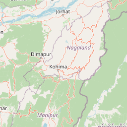
Map view of East Karbi Anglong Wildlife Sanctuary

Use this park location map to pinpoint East Karbi Anglong Wildlife Sanctuary in India, understand its exact geographic position, and read its mapped placement within the surrounding landscape more clearly.

Pigeon | © OpenStreetMap contributors

Location context for East Karbi Anglong Wildlife Sanctuary

Assam
Park atlas

Compare regional protected areas, rolling hill terrain, and connected wildlife habitats

Explore Parks Near East Karbi-Anglong Wildlife Sanctuary and Surrounding Hill Forests

Continue geographic discovery by comparing East Karbi-Anglong Wildlife Sanctuary with other protected areas across the surrounding regional uplands. Expanding the search reveals connected hill-forest reserves and similar wildlife habitats spanning the broader landscape.
National parkIndia
About 40 km away#1 closest

South

Intanki National Park: An Atlas Perspective on India's Protected Landscape

Mapping the boundaries and regional geography of this national park.

Delve into Intanki National Park, a significant protected area within India, through an atlas and map-focused lens. This detail page provides insights into its protected landscape identity, geographic setting, and the broader context of natural terrain found in India. Understand its specific placement and role within the national park system, offering a foundation for detailed geographic study and exploration.

Watercolor painting of green hills, fields, and a body of water
National parkAssam
About 73 km away#2 closest

North

Kaziranga National Park National Park: Protected Landscape and Geographic Atlas

Mapped boundaries and regional landscape context for this Assam natural area.

Delve into the detailed geographic profile of Kaziranga National Park, a prominent National Park located in Assam, India. This section focuses on its mapped protected area extent, its unique landscape characteristics within the Brahmaputra valley, and its role as a key natural landmark in northeastern India's atlas. Understand the structured geographic data and protected land identity that makes Kaziranga National Park a distinct entity for exploration.

Area
1,090 km²
Established
1905
IUCN
II
Relief
Lowland
Wildlife reserveAssam
About 95 km away#3 closest

Northwest

Bura Chapori Wildlife Sanctuary: Protected Grassland Geography in the Brahmaputra Valley

A vital wildlife reserve and buffer area within Assam's floodplain ecosystem.

Located in the Sonitpur district of Assam, Bura Chapori Wildlife Sanctuary offers a focused look at the Brahmaputra valley's dynamic floodplain environment. This protected area supports an essential mosaic of open grasslands and riverine woodlands, serving as a critical corridor for large mammals and endangered grassland birds. Its geography is deeply influenced by the seasonal rhythms of the Brahmaputra River, shaping the sanctuary as both a wetland habitat and a key conservation link.

Area
44.06 km²
Established
1974
IUCN
IV
Relief
Lowland
Wildlife reserveAssam
About 117 km away#4 closest

Southwest

Borail Wildlife Sanctuary: Protected Evergreen Forest Landscapes in the Barail Range

Exploring the terrain and habitat boundaries of southern Assam

Borail Wildlife Sanctuary spans the transition from the Surma valley floor to the hill country of the Barail range. This protected area serves as a critical refuge for primates, hornbills, and endemic plant species. The sanctuary offers a mapped look at one of the most ecologically significant, forest-covered landscapes in the Barak valley region, defined by steep ridges and monsoon-fed stream networks.

Area
326.24 km²
Established
2004
IUCN
IV
Relief
Mountain
National parkAssam
About 127 km away#5 closest

Northwest

Orang National Park: Assam's Key Floodplain Protected Landscape

Explore mapped boundaries and terrain context of this national park.

Orang National Park, located in Assam, India, is a significant protected area celebrated for its unique alluvial floodplain terrain and critical role in conservation. This national park provides a focused atlas-style view of grassland and wetland ecosystems, essential habitats for iconic species like the great Indian one-horned rhinoceros and Bengal tiger. Its geographical setting along the Brahmaputra River contributes to a dynamic landscape, offering rich context for understanding protected area distribution and regional natural features. Discover the mapped boundaries and ecological significance of this important protected land.

Area
78.81 km²
Established
1985
IUCN
II
Relief
Lowland
Wildlife reserveArunachal Pradesh
About 129 km away#6 closest

North

Itanagar Wildlife Sanctuary: Hill Forest Reserve and Protected Landscape in Arunachal Pradesh

Exploring the dense evergreen geography of a key Indian wildlife reserve

Spanning 140 square kilometres, Itanagar Wildlife Sanctuary preserves a vital mosaic of tropical semi-evergreen and wet evergreen forest within the foothills of Arunachal Pradesh. Bounded by the Pachin, Pam, Neorochi, and Chingke streams, this protected area offers a unique juxtaposition of dense hill forest and urban edges, functioning as a significant biodiversity habitat in northeastern India.

Area
140.3 km²
Established
1978
IUCN
IV
Relief
Upland
National parkSonitpur
About 134 km away#7 closest

Northwest

Nameri National Park: A Protected Landscape within Sonitpur's Geography

Explore the mapped terrain and national park boundaries.

Nameri National Park represents a significant protected natural area, contributing to the regional geography of Sonitpur, India. This page offers an atlas-oriented perspective, detailing the park's mapped landscape and its designation as a national park. Understand the geographic context and the protected land's specific identity within this mapped region.

Area
200 km²
Established
1978
IUCN
II
Relief
Mountain
Watercolor painting of Loktak Lake featuring green floating vegetation, calm water, and soft, distant rolling hills.
Wildlife reserveManipur
About 157 km away#8 closest

South

Loktak Lake Wildlife Reserve in Manipur: Mapping Floating Wetland Geography

Explore the unique terrain, mapped boundaries, and freshwater ecology of India's largest floating wetland

Loktak Lake Wildlife Reserve presents a distinctive landscape of shifting phumdi islands and expansive freshwater marshes within the Manipur Valley. This protected area offers deep geographic insight into a complex wetland system that pulses with the monsoon season, providing a critical refuge for biodiversity and maintaining hydrological balance in Northeast India.

Area
287 km²
Established
1990
Relief
Lowland
Climate
Tropical

Common questions about visiting, size, designation, and location context for East Karbi Anglong Wildlife Sanctuary

East Karbi Anglong Wildlife Sanctuary FAQs for park facts, access, geography, and protected area context

Find quick answers about East Karbi Anglong Wildlife Sanctuary, including protected-area facts, park geography, trail and visitor context, and how the park fits into its surrounding country and regional landscape.
MoriAtlas Explorer

Continue Your Protected Areas Search Across the Global Atlas

Deepen your exploration by continuing the structured search for national parks and protected areas worldwide. Utilize the comprehensive filtering capabilities to compare different conservation landscapes and refine your understanding of global park geography. Discover more about the distribution and characteristics of protected natural areas.

Global natural geography