Mori Atlas logo
Wildlife reserveBorail Wildlife Sanctuary

Tracing the elevation gradients and protected forest boundaries of this southern Assam wilderness refuge

Borail Wildlife Sanctuary: A Geographic Analysis of Tropical Forest Landscapes in Assam

Borail Wildlife Sanctuary encompasses a continuous expanse of moist tropical evergreen and semi-evergreen forest within the foothills of the Barail range. This protected area connects historic reserved forests to sustain a significant primate habitat and diverse hornbill populations across varying terrain. By integrating complex ridges and valleys into a single managed landscape, the sanctuary preserves essential ecological corridors within the broader geography of the Barak valley in southern Assam.

wildlife sanctuaryevergreen forestsemi-evergreen foresttropical foresthill forestprimate habitat

Borail Wildlife Sanctuary

Wildlife reserve

Park overview

Structured park overview, official facts, and landscape profile for Borail Wildlife Sanctuary

Borail Wildlife Sanctuary park facts, protected area profile, and essential visitor context

Review the core facts for Borail Wildlife Sanctuary, including designation, size, terrain, visitor scale, habitats, and operating context in one park-focused overview.

About Borail Wildlife Sanctuary

Borail Wildlife Sanctuary occupies a substantial forested block in the southern part of Assam, in northeastern India, situated within the Cachar district. It was created in 2004 through the merger of the long-standing North Cachar Reserved Forest and Barail Reserved Forest, bringing together two connected tracts of hill and valley forest into a single administratively protected area. The sanctuary lies roughly 40 kilometers from Silchar, the principal town of the Barak valley, making it one of the main natural areas accessible from this part of Assam.

Physically, the sanctuary spans a distance from about 55 meters to 1,500 meters above mean sea level, producing a vertical gradient that supports distinct forest types at different elevations. The Dima Hasao portion of the Barail range, while adjacent, is not part of the sanctuary. Rainfall is high, ranging from around 2,500 to 4,000 millimeters per year, and humidity stays substantial across most months, supporting persistently moist forest conditions.

Ecologically, Borail is significant because it preserves moist tropical evergreen and semi-evergreen forests that have largely disappeared from many parts of the Barak valley. These forests shelter an unusually rich mix of primates, large forest birds such as hornbills and pheasants, smaller carnivores, and an intriguing assemblage of endemic plants. The combination of varied elevation, intact canopy cover, and historical protected status has made Borail an important refuge for Indo-Burmese biodiversity in the southern Brahmaputra-Barak transition zone of northeast India.

For travelers, the sanctuary offers a relatively approachable forest experience through trekking and birdwatching, allowing visitor-focused recreation without the higher infrastructure of better-known national parks in the region.

Quick facts and research context for Borail Wildlife Sanctuary

Borail Wildlife Sanctuary is an IUCN Category IV protected area established in 2004 in the Cachar district of southern Assam. It spans roughly 326 square kilometers and combines the formerly separate North Cachar and Barail Reserved Forests into one continuous habitat block. The terrain stretches from low-lying forest at about 55 meters elevation up to higher slopes near 1,500 meters, creating a gradient from tropical valley forest to montane-influenced hill forest.

The climate is strongly monsoonal, receiving between roughly 2,500 and 4,000 millimeters of rainfall annually, with temperatures spanning cool winter lows to hot summer highs. The sanctuary is recognized as a significant conservation area for primates, hornbills, and endemic plant species of northeast India, and it lies within easy reach of the regional hub of Silchar.

Park context

Deeper park guide and search-rich context for Borail Wildlife Sanctuary

Borail Wildlife Sanctuary history, landscape, wildlife, and travel context

Explore Borail Wildlife Sanctuary through its history, landscape character, ecosystems, wildlife, conservation priorities, cultural context, and seasonal travel timing in a structured park guide built for atlas discovery and search intent.

Why Borail Wildlife Sanctuary stands out

Borail Wildlife Sanctuary is best known for its populations of primates and hornbills set within extensive moist tropical evergreen and semi-evergreen forest. The sanctuary supports species such as the hoolock gibbon, capped langur, clouded leopard, and several hornbills including the great pied, oriental pied, rufous-necked, wreathed, and Austen's brown hornbill. It is also notable as a botanical area where several endemic plant species of northeast India, including orchids, ginger relatives, and trees of the ebony and laurel families, were first described from within the sanctuary's forests.

Borail Wildlife Sanctuary history and protected-area timeline

The idea of protecting the forests of the Barail range dates back to the 1980s, when field surveys proposed the area for designation as either a national park or a wildlife sanctuary. Although the full Barail range straddles administrative boundaries, the Cachar portion, formed by the historically recognized North Cachar Reserved Forest and Barail Reserved Forest, was later selected for protected-area status.

In 2004, both reserved forests were formally merged under the new designation of Borail Wildlife Sanctuary, creating a unified protected area of approximately 326 square kilometers within the Cachar district of southern Assam. The consolidation brought together previously separate administrative forest units into a single sanctuary with consistent habitat management.

Since its establishment, Borail Wildlife Sanctuary has been recognized for its role in conserving primate populations, hornbills, and endemic plant species, while also serving as a recreational forest destination for residents and visitors to the Barak valley region. The sanctuary's foundation combined older colonial-era forest protection frameworks with modern wildlife conservation priorities.

Borail Wildlife Sanctuary landscape and geographic character

Borail Wildlife Sanctuary is set within the foothills and slopes of the Barail range, where terrain rises from the broader plains of the Surma valley system into hill country bordering Dima Hasao. Elevations span an impressive range, from approximately 55 meters above mean sea level along the lower forest valleys to around 1,500 meters on the higher slopes, producing a varied topography of ridges, stream valleys, and forested hillsides.

The landscape is shaped by heavy monsoon rainfall, which feeds numerous streams and supports dense vegetation cover across most of the sanctuary. Lower elevations carry more tropical evergreen character, while higher slopes show a shift toward semi-evergreen and montane-influenced forest, reflecting the climatic gradient created by altitude. Steep forested slopes, narrow valleys, and persistent humidity give the sanctuary a deeply wooded, layered appearance.

Although not a typical tourism-focused landscape, Borail presents the kind of visually undisturbed forest scenery that is increasingly rare in the Barak valley, with continuous canopy broken only by rivers, ridges, and the occasional clearing.

Borail Wildlife Sanctuary ecosystems, habitats, and plant life

The sanctuary protects extensive tracts of moist tropical evergreen and semi-evergreen forest, a habitat type that has become increasingly fragmented across the southern Assam landscape. These forests are characterized by tall canopy trees, multilayered understory, and abundant epiphytes that thrive in the persistently humid conditions.

Botanically, Borail is significant as a refuge for several endemic species of northeast India. The epiphytic orchid Ornithochilus cacharensis, the terrestrial ginger relative Larsenianthus assamensis, the small deciduous tree Diospyros cacharensis of the ebony family, and the large tree Alseodaphne keenanii of the laurel family were all described as new species based on material from within the sanctuary. This level of botanical novelty highlights how poorly explored and biologically distinctive the forests of the Barak valley remain.

Faunal diversity mirrors the habitat complexity. Primate species dominate the canopy across multiple elevations, while ground-dwelling mammals, large forest birds, and reptiles occupy different layers of the ecosystem. The combination of high rainfall, varied terrain, and continuous forest cover creates conditions favorable for an unusually rich mix of Indo-Burmese plant and animal species.

Borail Wildlife Sanctuary wildlife and species highlights

Borail Wildlife Sanctuary supports a notably diverse mammal community for an area of its size. Primates are particularly well represented, with records of slow loris, hoolock gibbon, capped langur, Assamese macaque, pig-tailed macaque, stump-tailed macaque, and rhesus monkey. Carnivores documented in the sanctuary include the Himalayan black bear, Malayan sun bear, leopard cat, jungle cat, golden cat, and clouded leopard. Other mammals of note include barking deer, red serow, and wild pig.

Birdlife is one of the sanctuary's strongest features, with more than 300 recorded species making it a significant destination for birdwatchers in northeast India. Among its most distinctive birds are the white-backed vulture, slender-billed vulture, rufous-throated and white-cheeked hill partridges, grey peacock pheasant, kaleej pheasant, great pied hornbill, oriental pied hornbill, rufous-necked hornbill, wreathed hornbill, and Austen's brown hornbill. The presence of multiple hornbill species, in particular, signals the integrity of the sanctuary's tall evergreen canopy.

Reptile life also contributes to the sanctuary's biodiversity, with species such as the Burmese rock python and king cobra recorded within its boundaries. The combination of primates, forest carnivores, hornbills, pheasants, vultures, and large reptiles underscores Borail's role as a multi-layered wildlife refuge in southern Assam.

Borail Wildlife Sanctuary conservation status and protection priorities

Borail Wildlife Sanctuary has conservation significance that extends well beyond its protected-area designation. By merging the North Cachar and Barail Reserved Forests into a single block, the sanctuary preserved forest connectivity that would otherwise have been vulnerable to encroachment, fragmentation, and shifting land use in the Barak valley. The resulting continuous habitat supports species that require large, undisturbed forest ranges, including the hoolock gibbon, capped langur, clouded leopard, and several hornbill species.

The sanctuary's documented role as a habitat for threatened and endemic species adds to its conservation value. Newly described endemic plant species, combined with important populations of primates and large forest birds, mark Borail as a priority site for understanding and protecting the biodiversity of northeast India. Its recognition as an IUCN Category IV area reflects its purpose as a managed habitat for species conservation rather than a strictly restricted nature reserve.

Ongoing significance lies in maintaining the integrity of its moist tropical evergreen forest cover, protecting water sources that originate within the sanctuary, and supporting regional biodiversity pipelines between Assam's southern hill forests and adjacent protected landscapes.

Top sights and standout views in Borail Wildlife Sanctuary

Borail Wildlife Sanctuary stands out as one of southern Assam's most ecologically significant protected areas, distinguished by its combination of primate-rich evergreen forest, abundant hornbill populations, and endemic plant discoveries. Its merger of two historic reserved forests into a single sanctuary in 2004 preserved a continuous habitat block that supports more than 300 bird species and a wide range of mammals.

Just as importantly, Borail represents a relatively accessible entry point into the natural landscape of the Barak valley for visitors based in or near Silchar, offering trekking and birdwatching opportunities within a forest that retains strong ecological character despite the pressures affecting much of the surrounding region.

Best time to visit Borail Wildlife Sanctuary

The best time to visit Borail Wildlife Sanctuary generally falls outside the heaviest monsoon months, when rainfall can limit access and make forest trails difficult. The cooler and drier months of late autumn through early spring are typically the most comfortable period, offering more stable weather for trekking and improved visibility for birdwatching.

Spring can be a rewarding season for observing hornbills and other forest birds, while winter often brings cooler nights and pleasant daytime temperatures in the lower elevations of the sanctuary. Visitors should generally expect high humidity throughout much of the year, given the area's heavy annual rainfall.
Monthly climate preview

Long-term representative point measurements of monthly temperature and precipitation rhythms in Assam

Borail Wildlife Sanctuary Climate Normals and Annual Temperature Patterns

Borail Wildlife Sanctuary records measured monthly temperature and precipitation averages from representative coordinate datasets spanning 1991 through 2020. Examining the complete twelve-month climate profile reveals detailed patterns across daily minimum and maximum temperature ranges.
Annual mean24 °C
16 °C27 °C
Jan16°
Feb19°
Mar24°
Apr26°
May27°
Jun27°
Jul27°
Aug27°
Sep27°
Oct25°
Nov21°
Dec17°
Warmest month
June

27.5 °C

Coolest month
January

16.2 °C

Wettest month
June

15.4 mm/day

Driest month
January

0.3 mm/day

Park location guide

Geography guide, regional context, and park location map for Borail Wildlife Sanctuary

Borail Wildlife Sanctuary park geography, regions, and map view in India

Understand where Borail Wildlife Sanctuary sits in India through a broader geographic reading of the surrounding landscape, nearby location context, and its mapped position within the national park landscape.

How Borail Wildlife Sanctuary fits into India

India is a South Asian country bordered by the Indian Ocean, Arabian Sea, and Bay of Bengal. It shares land borders with Pakistan, China, Nepal, Bhutan, Bangladesh, and Myanmar. The country has a population of over 1.4 billion people and operates as a federal parliamentary republic with its capital in New Delhi.

Wider geography shaping Borail Wildlife Sanctuary in India

India occupies the Indian subcontinent in South Asia, bordered by the Arabian Sea to the southwest, the Bay of Bengal to the southeast, and the Indian Ocean to the south. It shares land borders with Pakistan to the west, China, Nepal, and Bhutan to the north, and Bangladesh and Myanmar to the east. The territory also includes the Andaman and Nicobar Islands in the Indian Ocean.

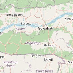
Map view of Borail Wildlife Sanctuary

Use this park location map to pinpoint Borail Wildlife Sanctuary in India, understand its exact geographic position, and read its mapped placement within the surrounding landscape more clearly.

Pigeon | © OpenStreetMap contributors

Location context for Borail Wildlife Sanctuary

Assam
Park atlas

Compare regional hill forests, wildlife habitats, and surrounding protected landscapes

Explore Protected Areas and Parks Near Borail Wildlife Sanctuary

Browse neighboring protected areas and regional reserves to compare the tropical evergreen terrain surrounding Borail Wildlife Sanctuary. Extending geographic research across nearby hill forests reveals the broader ecological spread of northeast India.
Watercolor painting showing grasses in the foreground, a body of water, and hilly terrain under a pale sky
National parkSylhet District
About 76 km away#1 closest

West

Khadim Nagar National Park: Bangladesh National Park with Sylhet District Geographic Context

Mapped protected landscape and regional park identity.

Khadim Nagar National Park stands as a significant national park within Sylhet District, Bangladesh, offering a focused point for understanding protected land distribution and geographic features. This entry serves as a resource for exploring the park's specific boundaries and its role within the larger atlas of natural landscapes. Users can gain a clear view of its protected status and its place within the regional geography, facilitating detailed park exploration.

Area
6.79 km²
Established
2006
IUCN
II
Relief
Mixed relief
National parkIndia
About 94 km away#2 closest

Northeast

Intanki National Park: An Atlas Perspective on India's Protected Landscape

Mapping the boundaries and regional geography of this national park.

Delve into Intanki National Park, a significant protected area within India, through an atlas and map-focused lens. This detail page provides insights into its protected landscape identity, geographic setting, and the broader context of natural terrain found in India. Understand its specific placement and role within the national park system, offering a foundation for detailed geographic study and exploration.

Wildlife reserveAssam
About 117 km away#3 closest

Northeast

East Karbi-Anglong Wildlife Sanctuary: Geographic Overview and Hill Forest Map

Protected wildlife reserve within the Karbi Anglong district of Assam.

The East Karbi-Anglong Wildlife Sanctuary occupies a significant portion of the Karbi Anglong plateau, encompassing 222 square kilometers of rolling hills and narrow valleys. This protected area supports a mosaic of forest habitats, ranging from moist evergreen patches to drier deciduous ridges. It functions as an essential refuge for tigers, elephants, and primates, while maintaining a rich avian community of approximately 250 recorded species.

Area
221.81 km²
Established
2000
IUCN
IV
Relief
Upland
National parkMoulvibazar District
About 124 km away#4 closest

Southwest

Lawachara National Park: Protected National Park Landscape in Moulvibazar District

Mapped Terrain and Endangered Primate Habitat Exploration

Delve into the protected landscape of Lawachara National Park, a key national park located in the distinct undulating terrain of Moulvibazar District, Bangladesh. This area is recognized for its ecological significance, particularly as a sanctuary for endangered primates, including the critically important western hoolock gibbon population. Users can explore the park's mapped boundaries, understand its semi-evergreen forest ecosystem, and appreciate its geological features like sandstone hillocks and sandy-bedded streams, making it a valuable point of discovery for regional geography and conservation landscapes.

Area
12.5 km²
Established
1996
IUCN
II
Relief
Upland
Watercolor painting of Loktak Lake featuring green floating vegetation, calm water, and soft, distant rolling hills.
Wildlife reserveManipur
About 126 km away#5 closest

Southeast

Loktak Lake Wildlife Reserve in Manipur: Mapping Floating Wetland Geography

Explore the unique terrain, mapped boundaries, and freshwater ecology of India's largest floating wetland

Loktak Lake Wildlife Reserve presents a distinctive landscape of shifting phumdi islands and expansive freshwater marshes within the Manipur Valley. This protected area offers deep geographic insight into a complex wetland system that pulses with the monsoon season, providing a critical refuge for biodiversity and maintaining hydrological balance in Northeast India.

Area
287 km²
Established
1990
Relief
Lowland
Climate
Tropical
National parkManipur
About 128 km away#6 closest

Southeast

Keibul Lamjao National Park: Mapped Boundaries and Protected Landscape Identity

Explore Manipur's unique national park geography and terrain.

Keibul Lamjao National Park represents a key protected area within the state of Manipur, India, offering critical insights into regional geography and protected landscape dynamics. This national park's unique environmental setting provides an excellent opportunity for structured atlas exploration, allowing users to understand its mapped boundaries and its significance within the subcontinent's network of conservation areas. Discover the specific geographic context and natural terrain that define Keibul Lamjao National Park.

Area
40 km²
Established
1977
IUCN
II
Relief
Lowland
Wildlife reserveAssam
About 159 km away#7 closest

North

Bura Chapori Wildlife Sanctuary: Protected Grassland Geography in the Brahmaputra Valley

A vital wildlife reserve and buffer area within Assam's floodplain ecosystem.

Located in the Sonitpur district of Assam, Bura Chapori Wildlife Sanctuary offers a focused look at the Brahmaputra valley's dynamic floodplain environment. This protected area supports an essential mosaic of open grasslands and riverine woodlands, serving as a critical corridor for large mammals and endangered grassland birds. Its geography is deeply influenced by the seasonal rhythms of the Brahmaputra River, shaping the sanctuary as both a wetland habitat and a key conservation link.

Area
44.06 km²
Established
1974
IUCN
IV
Relief
Lowland
National parkHabiganj District
About 164 km away#8 closest

Southwest

Satchari National Park: Mapped Protected Landscape in Habiganj District

Discover regional geography and park boundaries.

Satchari National Park represents a significant protected area within Bangladesh, situated in Habiganj District. This entry focuses on its identity as a national park, detailing its geographic footprint and landscape context. Explore the mapped dimensions of this protected land to better understand its role in the regional atlas and its specific natural terrain.

Area
2.43 km²
Established
2005
IUCN
II
Relief
Highland

Common questions about visiting, size, designation, and location context for Borail Wildlife Sanctuary

Borail Wildlife Sanctuary FAQs for park facts, access, geography, and protected area context

Find quick answers about Borail Wildlife Sanctuary, including protected-area facts, park geography, trail and visitor context, and how the park fits into its surrounding country and regional landscape.
MoriAtlas Explorer

Continue Your Protected Areas Search Across the Global Atlas

Deepen your exploration by continuing the structured search for national parks and protected areas worldwide. Utilize the comprehensive filtering capabilities to compare different conservation landscapes and refine your understanding of global park geography. Discover more about the distribution and characteristics of protected natural areas.

Global natural geography