Mori Atlas logo
National parkKeibul Lamjao National Park

Discover the unique protected area boundaries and natural terrain within Manipur's national park.

Keibul Lamjao National Park: Protected Landscape and Mapped Geography in Manipur

Keibul Lamjao National Park stands as a significant protected area within the region of Manipur, India. This national park offers a distinct geographic landscape, serving as a crucial element for understanding the protected territories of the subcontinent. MoriAtlas provides detailed mapping and regional context, allowing for a comprehensive exploration of Keibul Lamjao National Park's unique terrain and its place within the broader atlas of Indian protected lands.

Floating National ParkWetland EcosystemEndangered Species ConservationRamsar SitePhumdi EcosystemSangai Deer Habitat

Keibul Lamjao National Park

National park

Park overview

Structured park overview, official facts, and landscape profile for Keibul Lamjao National Park

Keibul Lamjao National Park park facts, protected area profile, and essential visitor context
Review the core facts for Keibul Lamjao National Park, including designation, size, terrain, visitor scale, habitats, and operating context in one park-focused overview.

About Keibul Lamjao National Park

Keibul Lamjao National Park represents one of India's most ecologically unique protected areas, situated in the heart of Manipur's wetland landscape. The park's foundation rests upon the extraordinary phumdi ecosystem, where layers of decomposing vegetation, biomass, and soil particles have consolidated into floating islands that rise and fall with the water levels of Loktak Lake. These phumdis cover approximately two-thirds to three-quarters of the park's total area and vary in thickness from one to four feet, with about twenty percent of their mass floating above the water surface, sufficient to support the weight of large mammals like the Sangai deer. The park encompasses three prominent hills—Pabot, Toya, and Chingjao—which provide crucial refuge for wildlife during the monsoon season when water levels rise substantially. The park's designation as an integral part of the Loktak Lake system, itself a Ramsar wetland site, underscores its international ecological significance. It is currently on the tentative list for UNESCO World Heritage status under the title Keibul Lamjao Conservation Area, a designation that would recognize its outstanding universal value. The park is managed jointly by the Government of India and the Government of Manipur, though its boundary and size have fluctuated over the years due to various pressures, including reductions from the original 4,000 hectares to 2,160 hectares in 1998.

Quick facts and research context for Keibul Lamjao National Park

Keibul Lamjao National Park covers 40 square kilometers in Bishnupur district, Manipur, in Northeast India. Established on 28 March 1977 as a national park (originally declared as a wildlife sanctuary in 1966), it is the world's only floating national park and forms part of the Loktak Lake system. The park is centered on phumdis, a unique floating mass of organic vegetation that varies in thickness and creates a distinctive ecosystem supporting the endangered Sangai deer. The park is on UNESCO's tentative list for World Heritage status as the Keibul Lamjao Conservation Area, which also encompasses the buffer zones of Loktak Lake and Pumlen Pat.

Park context

Deeper park guide and search-rich context for Keibul Lamjao National Park

Keibul Lamjao National Park history, landscape, wildlife, and travel context
Explore Keibul Lamjao National Park through its history, landscape character, ecosystems, wildlife, conservation priorities, cultural context, and seasonal travel timing in a structured park guide built for atlas discovery and search intent.

Why Keibul Lamjao National Park stands out

Keibul Lamjao National Park is world-renowned as the only floating national park on Earth, a distinction that sets it apart among protected areas globally. The park's defining feature is the phumdi, a thick mat of decomposed vegetation and organic matter that floats on the lake surface, creating a buoyant landscape capable of supporting large mammals. However, the park's most celebrated resident is the Sangai, or brow-antlered deer, an endangered subspecies of Eld's deer that exists nowhere else in the world. This deer population, which once declined to just 14 individuals in 1975, has recovered to approximately 260 animals through conservation efforts. The park also hosts significant bird populations including the threatened hooded crane and the Burmese sarus crane, making it a vital habitat for both migratory and resident avian species.

Keibul Lamjao National Park history and protected-area timeline

The establishment of Keibul Lamjao National Park is inextricably linked to the conservation story of the brow-antlered deer, a species that has captured both scientific and cultural attention in Manipur. The brow-antlered deer, first discovered in Manipur in 1839 and formally described as Cervus eldi eldi in 1844 in honor of British officer Lt. Percy Eld, was tragically reported as extinct in 1951. The species was subsequently rediscovered in the Keibul Lamjao area by the renowned environmentalist and photographer E.P. Gee, a discovery that catalyzed the protection of this unique habitat. The area was initially declared a wildlife sanctuary in 1966 specifically to preserve the natural habitat of this endangered deer subspecies. Recognizing the critical importance of the ecosystem, the reserve was elevated to national park status and gazetted in 1977. Throughout its conservation history, the Sangai population has served as both a symbol and a measure of success. From a precarious population of just 14 individuals in 1975, conservation efforts helped grow the herd to 155 by 1995, and the latest wildlife census conducted in March 2016 recorded approximately 260 individuals. The park has also gained recognition through cultural mediums, including the documentary The Return of Sangai (Sangai Hallakpa) produced by the Manipur Forest Department in both English and Manipuri languages.

Keibul Lamjao National Park landscape and geographic character

The landscape of Keibul Lamjao National Park is defined by its extraordinary floating ecosystem, a phenomenon found nowhere else in the world's protected areas. The park occupies the south-eastern region of Loktak Lake, a vast freshwater lake that forms the largest wetland in Northeast India. The most distinctive feature of the park is the phumdi, a complex mat of organic detritus and biomass that has accumulated and thickened over time into a solid but floating mass. These phumdis are not merely surface vegetation but are substantial structures that extend from the lake bed in some areas while floating buoyantly in others. The vegetation on these floating mats includes dense stands of Phragmites karka (common reed), elephant grass, Saccharum species, and the wild rice Zizania latifolia, which is particularly relished by the Sangai deer. Three hills—Pabot, Toya, and Chingjao—rise from within the park boundary, providing terrestrial refuge zones that become especially important during the monsoon flooding. The park exhibits a unique hydrological character described as "too deep to be marsh, too shallow to be a lake," reflecting its intermediate nature in the wetland classification. The water depths and phumdi thickness fluctuate seasonally, with the park's overall extent varying considerably between the wet monsoon months and the drier winter period.

Keibul Lamjao National Park ecosystems, habitats, and plant life

The ecological character of Keibul Lamjao National Park represents a remarkable blend of aquatic, wetland, and terrestrial ecosystems within a floating landscape. The park's vegetation is primarily classified as moist semi-evergreen forest, though the floating phumdi communities form the most distinctive ecological element. The phumdi vegetation has been structurally analyzed and contains a diverse assemblage of plant species, with Phragmites karka dominating at approximately 45 percent, followed by elephant grass at 25 percent, and various Saccharum species contributing to the remaining composition. The park supports two distinct types of phumdi: the phumdi ataoba, which floats on the surface and supports emergent vegetation, and the phumdi aruppa, which has sunk to the lake bed but continues to support rich growth of reeds and grasses. The aquatic environment contains numerous species including the water hyacinth (Eichhornia crassipes), the sacred lotus (Nelumbo nucifera), and various submerged and emergent macrophytes. The three hills surrounding the park, once covered in vegetation, have become increasingly denuded over time, though they continue to serve important ecological functions as wildlife refugia. The park's location within the broader Loktak Lake Ramsar site further emphasizes its role as a critical wetland ecosystem of international importance.

Keibul Lamjao National Park wildlife and species highlights

The wildlife of Keibul Lamjao National Park is centered on the preservation of the brow-antlered deer, known locally as the Sangai, which serves as the park's flagship species. This endangered subspecies of Eld's deer exists in only this single location globally, making the park irreplaceable for its survival. Beyond the Sangai, the park supports a diverse mammalian community including hog deer, wild boar, large Indian civet, common otter, jungle cat, Asian golden cat, sambar deer, and various smaller mammals including bamboo rats, muskrats, and flying foxes. The reptilian fauna is particularly diverse, with species including various kraits, cobras, the Asian rock python, Russell's viper, and the checkered garter snake. Amphibians and aquatic reptiles include the keelback tortoise and several other turtle species. The park's avifauna is especially notable, with both migratory and resident bird species recorded. Significant bird species include the threatened hooded crane, the Burmese sarus crane, spotbill duck, blue-winged teal, ruddy shell duck, and various kingfishers, mynas, drongos, and woodpeckers. The fish population includes species such as Channa striata, common carp, Wallago attu, and pool barb, which support both ecological functions and local livelihoods.

Keibul Lamjao National Park conservation status and protection priorities

The conservation significance of Keibul Lamjao National Park extends beyond its role as a refuge for the Sangai deer to encompass broader wetland ecosystem preservation and cultural heritage protection. The park's inclusion on UNESCO's tentative list for World Heritage status as the Keibul Lamjao Conservation Area recognizes its outstanding universal value, with the designation also encompassing the Loktak Lake buffer zone and Pumlen Pat. However, the park faces significant conservation challenges, primarily stemming from the construction of the Ithai Barrage under the Loktak Multi-Purpose Project in 1983. This hydroelectric infrastructure altered the natural water level cycles that historically governed the floating and sinking dynamics of the phumdi, leaving them permanently floating and reducing their thickness and ecological function. Conservation measures implemented include a perimeter fence spanning 2,281 meters, a cattle-proof trench along 870 meters of the boundary, and the establishment of seven canoes and four checkpoints for security. The park is staffed with dedicated personnel including an Assistant Conservator of Forests, a veterinary surgeon, rangers, field assistants, foresters, and forest guards. Conservation priorities include habitat monitoring, strict protection of core areas, water level management, prevention of phumdi theft, and community engagement through ecotourism and educational programs.

Keibul Lamjao National Park cultural meaning and human context

Keibul Lamjao National Park holds profound cultural significance for the people of Manipur, extending far beyond its ecological value as a protected area. The Sangai deer occupies a sacred place in Meitei folklore and culture, representing not merely a wildlife species but a symbol of state identity recognized officially as the state animal of Manipur. The park and the broader Loktak Lake ecosystem have provided sustenance for local communities for generations, with fishing, vegetable cultivation, and resource collection from the phumdis forming traditional livelihoods. The Meitei language name for the park, Keibul Lamjao Leipakki Lampak, reflects the deep connection between the landscape and local identity. The park's cultural importance is further emphasized through documentary productions like The Return of Sangai, created by the Manipur Forest Department in both English and Manipuri languages. Traditional land use practices, including the collection of resources from phumdis, have shaped the human-environment relationship in this landscape for centuries, though modern conservation needs and traditional practices sometimes come into tension.

Top sights and standout views in Keibul Lamjao National Park

Keibul Lamjao National Park stands as a singular natural phenomenon, the world's only floating national park, where visitors can witness an ecosystem built on buoyant islands of decomposing vegetation supporting a population of the endangered Sangai deer. The park offers a distinctive visitor experience through boat trips along labyrinthine water routes that wind through colorful aquatic vegetation and floating phumdi formations. The optimal times for wildlife viewing are during the early morning hours between 0600 and 1000 and in the afternoon from 1530 to 1800, when the Sangai deer emerge from the phumdi to feed in herds. The recovery of the Sangai population from just 14 individuals in 1975 to approximately 260 in 2016 represents one of India's most successful conservation stories. The park's position within the Loktak Lake Ramsar site and its tentative UNESCO World Heritage status underscore its international ecological importance.

Best time to visit Keibul Lamjao National Park

The best time to visit Keibul Lamjao National Park coincides with the seasons when wildlife viewing is most productive and the park's unique floating landscape is most accessible. The ideal visiting periods are during the early morning hours between 0600 and 1000 and in the afternoon from 1530 to 1800, when the Sangai deer leave the shelter of the phumdi vegetation to feed in visible herds. The park can be experienced year-round, though visitors should be aware that the monsoon season brings significant flooding that changes the park's character and may temporarily affect accessibility. During the dry season, the phumdi conditions stabilize and wildlife viewing opportunities improve. The climate of Manipur ranges from hot summers with temperatures reaching 34.4°C to cool winters with minimum temperatures around 1.7°C, with the monsoon months of July and August receiving the heaviest rainfall. Visitors interested in birdwatching should consider the migratory bird seasons when species like the hooded crane visit the park.

Park location guide

Geography guide, regional context, and park location map for Keibul Lamjao National Park

Keibul Lamjao National Park park geography, regions, and map view in India
Understand where Keibul Lamjao National Park sits in India through a broader geographic reading of the surrounding landscape, nearby location context, and its mapped position within the national park landscape.

How Keibul Lamjao National Park fits into India

India is a South Asian country bordered by the Indian Ocean, Arabian Sea, and Bay of Bengal. It shares land borders with Pakistan, China, Nepal, Bhutan, Bangladesh, and Myanmar. The country has a population of over 1.4 billion people and operates as a federal parliamentary republic with its capital in New Delhi.

Wider geography shaping Keibul Lamjao National Park in India

India occupies the Indian subcontinent in South Asia, bordered by the Arabian Sea to the southwest, the Bay of Bengal to the southeast, and the Indian Ocean to the south. It shares land borders with Pakistan to the west, China, Nepal, and Bhutan to the north, and Bangladesh and Myanmar to the east. The territory also includes the Andaman and Nicobar Islands in the Indian Ocean.

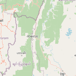
Map view of Keibul Lamjao National Park

Use this park location map to pinpoint Keibul Lamjao National Park in India, understand its exact geographic position, and read its mapped placement within the surrounding landscape more clearly.

Pigeon | © OpenStreetMap contributors

Location context for Keibul Lamjao National Park

Bishnupur DistrictManipur
Park atlas

Compare regional park geography and trace connected protected landscapes near Keibul Lamjao National Park.

Discover Other National Parks and Protected Areas Near Keibul Lamjao National Park
Browse additional national parks and protected areas located in the region surrounding Keibul Lamjao National Park, exploring diverse wetland ecosystems and local conservation efforts. Expanding your geographic view provides deeper understanding of connected protected landscapes and regional park patterns across Northeast India.
National parkManipur

Shirui National Park: Detailed Protected Landscape and Regional Geography in Manipur

Mapped boundaries and atlas context for this national park.

Shirui National Park serves as a vital protected area within the state of Manipur, offering a unique focal point for geographic exploration. This profile details its identity as a national park, emphasizing its mapped boundaries and landscape context. For users interested in atlas-based discovery and understanding the distribution of protected lands, Shirui National Park provides critical data on regional geography and conservation. Examine its position within India's natural terrain and protected area network.

Area
41.3 km²
Established
1982
IUCN
II
Relief
Mountain
National parkChamphai

Murlen National Park: Mapped Protected Landscape and Regional Geographic Context

National Park discovery in Champhai, India.

Delve into the specifics of Murlen National Park, a key protected area situated in the Champhai region. This entry focuses on its identity as a National Park, providing critical information about its geographic placement and mapped boundaries. Understanding Murlen National Park within its regional landscape context is fundamental for comprehensive atlas-based exploration of India's protected areas.

Area
200 km²
Established
1991
IUCN
II
Relief
Mountain
Watercolor painting showing grasses in the foreground, a body of water, and hilly terrain under a pale sky
National parkSylhet District

Khadim Nagar National Park: Bangladesh National Park with Sylhet District Geographic Context

Mapped protected landscape and regional park identity.

Khadim Nagar National Park stands as a significant national park within Sylhet District, Bangladesh, offering a focused point for understanding protected land distribution and geographic features. This entry serves as a resource for exploring the park's specific boundaries and its role within the larger atlas of natural landscapes. Users can gain a clear view of its protected status and its place within the regional geography, facilitating detailed park exploration.

Area
6.79 km²
Established
2006
IUCN
II
Relief
Mixed relief
National parkMoulvibazar District

Lawachara National Park: Protected National Park Landscape in Moulvibazar District

Mapped Terrain and Endangered Primate Habitat Exploration

Delve into the protected landscape of Lawachara National Park, a key national park located in the distinct undulating terrain of Moulvibazar District, Bangladesh. This area is recognized for its ecological significance, particularly as a sanctuary for endangered primates, including the critically important western hoolock gibbon population. Users can explore the park's mapped boundaries, understand its semi-evergreen forest ecosystem, and appreciate its geological features like sandstone hillocks and sandy-bedded streams, making it a valuable point of discovery for regional geography and conservation landscapes.

Area
12.5 km²
Established
1996
IUCN
II
Relief
Upland
National parkIndia

Phawngpui National Park: An Indian National Park's Protected Landscape and Geography

Explore its mapped boundaries and regional natural terrain.

Phawngpui National Park stands as a distinct protected area within India, contributing significantly to the nation's atlas of natural landscapes. Its designation as a national park underscores its importance for understanding regional geography and mapped terrain. This profile focuses on the park's specific protected-area identity and its role in the broader geographic context of India, offering clear insights for landscape and park map discovery.

Area
50 km²
Established
1992
IUCN
II
Visitors
469 annual
National parkHabiganj District

Satchari National Park: Mapped Protected Landscape in Habiganj District

Discover regional geography and park boundaries.

Satchari National Park represents a significant protected area within Bangladesh, situated in Habiganj District. This entry focuses on its identity as a national park, detailing its geographic footprint and landscape context. Explore the mapped dimensions of this protected land to better understand its role in the regional atlas and its specific natural terrain.

Area
2.43 km²
Established
2005
IUCN
II
Relief
Highland
Watercolor painting of green hills, fields, and a body of water
National parkAssam

Kaziranga National Park National Park: Protected Landscape and Geographic Atlas

Mapped boundaries and regional landscape context for this Assam natural area.

Delve into the detailed geographic profile of Kaziranga National Park, a prominent National Park located in Assam, India. This section focuses on its mapped protected area extent, its unique landscape characteristics within the Brahmaputra valley, and its role as a key natural landmark in northeastern India's atlas. Understand the structured geographic data and protected land identity that makes Kaziranga National Park a distinct entity for exploration.

Area
1,090 km²
Established
1905
IUCN
II
Relief
Lowland
National parkSagaing Region

Alaungdaw Kathapa National Park: National Park with Mapped Boundaries in Sagaing Region

Explore its protected landscape and regional geography.

Alaungdaw Kathapa National Park is a protected natural area situated in Myanmar's Sagaing Region. This national park is defined by its specific geographic boundaries and serves as a key component within the regional landscape atlas. Its designation highlights its importance for conservation and offers insights into the natural terrain and protected area distribution, providing a focused entry for geographic study.

Area
1,403 km²
Established
1989
IUCN
II
Relief
Mountain

Common questions about visiting, size, designation, and location context for Keibul Lamjao National Park

Keibul Lamjao National Park FAQs for park facts, access, geography, and protected area context
Find quick answers about Keibul Lamjao National Park, including protected-area facts, park geography, trail and visitor context, and how the park fits into its surrounding country and regional landscape.
MoriAtlas Explorer

Continue Your Protected Areas Search Across the Global Atlas

Deepen your exploration by continuing the structured search for national parks and protected areas worldwide. Utilize the comprehensive filtering capabilities to compare different conservation landscapes and refine your understanding of global park geography. Discover more about the distribution and characteristics of protected natural areas.

Global natural geography