

Mori Atlas logo
National parkShirui National Park

Trace the mapped boundaries and geographic context of this national park in Manipur.

Shirui National Park: National Park Protected Landscape and Manipur Geography Atlas

Shirui National Park represents a distinct protected landscape within the geographic region of Manipur, India. As a designated national park, its core value lies in understanding its mapped boundaries and its contribution to the regional geography. This MoriAtlas entry focuses on providing an atlas-oriented perspective, detailing the park's setting and its role as a protected area, crucial for comprehensive geographic discovery. Explore the natural terrain and protected lands that define this significant Indian conservation landscape.

Himalayan national parksEndemic flower habitatsBirdwatching destinationsTropical and temperate forestsNortheast India parksMountain ecosystems

Shirui National Park

National park

Park overview

Structured park overview, official facts, and landscape profile for Shirui National Park

Shirui National Park park facts, protected area profile, and essential visitor context

Review the core facts for Shirui National Park, including designation, size, terrain, visitor scale, habitats, and operating context in one park-focused overview.

About Shirui National Park

Shirui National Park occupies a significant position among India's protected areas as a sanctuary for the unique biodiversity of the eastern Himalayan region. The park is located in the Ukhrul district of Manipur, a state that sits at the crossroads of Indian and Southeast Asian ecological zones. The terrain is dominated by steep, forested slopes that rise from the valley floors to the alpine zones near the summit of Shirui Kashong Peak. This dramatic elevational gradient creates distinct ecological zones within the park, supporting both tropical forest species in the lower valleys and temperate forest communities on the cooler hilltops. The peak itself, at 2,835 meters, is both a geographic landmark and an important hydrological feature, with numerous rivers originating from its slopes to feed the surrounding landscape. The park's establishment in 1982 reflected growing recognition of the need to protect the region's endemic species and unique ecosystems from development pressures and habitat loss. Today, Shirui remains an important destination for nature enthusiasts, botanists, and those interested in experiencing the natural heritage of Manipur's Himalayan frontier.

Quick facts and research context for Shirui National Park

Shirui National Park is situated in Ukhrul district, Manipur, at the eastern edge of India near the border with Myanmar. The park was established in 1982 and covers roughly 41 square kilometers of mountainous terrain. The highest point is Shirui Kashong Peak at 2,835 meters elevation. The park is classified as an IUCN Category II protected area. It is famous for the Shirui lily, a endemic flower species that grows naturally within the park boundaries.

Protection and recognition

Mapping the terrestrial scope and official conservation frameworks within global database networks.

Documented Protection Status and Legal Designation of Shirui National Park

The terrestrial classification of Shirui National Park establishes its boundary as a dedicated conservation landscape under regional environmental frameworks. Verifying official terrestrial protection statuses helps researchers map regional conservation networks and evaluate ecological corridors across the global atlas.

Protection details

Protection scope
Terrestrial
Transboundary protection
No
Park context

Deeper park guide and search-rich context for Shirui National Park

Shirui National Park history, landscape, wildlife, and travel context

Explore Shirui National Park through its history, landscape character, ecosystems, wildlife, conservation priorities, cultural context, and seasonal travel timing in a structured park guide built for atlas discovery and search intent.

Why Shirui National Park stands out

Shirui National Park is best known for the Shirui lily (Lilium mackliniae), a distinctive pink-flowered lily that grows nowhere else in the world and is found only in this region of Manipur. The park is also distinguished by its altitudinal range spanning tropical forests at lower elevations to temperate forests and alpine meadows near the summit. Rare Himalayan bird species including Blyth's Tragopan and Mrs. Hume's bar-backed pheasant inhabit the higher reaches. The panoramic view from Shirui Kashong Peak, which serves as a watershed for several rivers, is considered a major scenic attraction.

Shirui National Park history and protected-area timeline

Shirui National Park was established in 1982 as part of India's expanding network of protected areas during the latter decades of the twentieth century. The creation of the park responded to growing conservation concerns about the unique ecosystems found in the northeastern Himalayan region of India, an area known for high levels of endemism and significant biodiversity. The selection of this particular area for protection reflected the presence of the endemic Shirui lily and the desire to conserve the watershed function of Shirui Kashong Peak. Manipur's protected area network grew substantially during this period, with Shirui joining other significant conservation spaces in the state. The park's management has focused on maintaining the biological integrity of the forest ecosystems while accommodating controlled visitor access to the area's natural attractions.

Shirui National Park landscape and geographic character

The physical landscape of Shirui National Park is defined by its mountainous character and the dramatic elevational range contained within its boundaries. The terrain rises steeply from lower valleys through increasingly steep slopes to reach the summit of Shirui Kashong Peak at 2,835 meters above sea level. The hillsides are heavily forested, with the forest cover varying with elevation from dense tropical forests in the lower reaches to temperate forest communities at higher elevations. Near the peak, the vegetation transitions to alpine meadows and shrubland characteristic of high-elevation Himalayan environments. The peak itself serves as a significant geographic feature, acting as a watershed from which several rivers originate to flow down through the surrounding landscape. The combination of forested slopes, rocky outcrops, grassy meadows, and river corridors creates a diverse scenic environment typical of Himalayan mountain parks.

Shirui National Park ecosystems, habitats, and plant life

The natural environment of Shirui National Park exhibits the ecological diversity characteristic of the eastern Himalayan region. The park contains both tropical forest ecosystems in its lower elevations and temperate forest communities as the terrain rises toward the summit. The tropical forests are dense and evergreen, while the temperate forests on the hilltops feature different tree species adapted to cooler conditions. This vertical zonation of vegetation supports a corresponding diversity of wildlife and creates a mosaic of habitats within a relatively compact protected area. The undisturbed nature of the biological system within the park has allowed natural ecological processes to continue relatively unimpeded. The Shirui lily, the park's most famous botanical resident, represents the endemic character of the region's flora and serves as an indicator species for the unique ecological conditions found in this part of Manipur.

Shirui National Park wildlife and species highlights

Shirui National Park is home to several notable animal species, including tigers and leopards among its larger predators. The park is particularly significant for its population of tragopans, a genus of pheasants that are prized for their colorful plumage. Blyth's Tragopan, a species of Himalayan mountain pheasant, inhabits the higher elevations of the park, as does Mrs. Hume's bar-backed pheasant. These bird species are among the park's most notable wildlife attractions, drawing attention from ornithologists and birdwatching enthusiasts. The diverse forest habitats support additional wildlife species, though the primary significance lies in the presence of these rare Himalayan bird species and the larger predator species that occupy the forested terrain.

Shirui National Park conservation status and protection priorities

Shirui National Park serves as an important conservation space for the unique biodiversity of Manipur's Himalayan region. The protection of this area preserves habitats for endemic species including the Shirui lily, which is found nowhere else on Earth, and rare Himalayan bird species such as Blyth's Tragopan. The park's location at the interface between tropical and temperate ecological zones means it contains a cross-section of species from different biogeographic origins. The watershed function of Shirui Kashong Peak adds ecological importance beyond biodiversity conservation, as the rivers originating from the peak support downstream ecosystems and local communities. As an IUCN Category II protected area, the park is managed with the goal of maintaining natural ecosystems while allowing for compatible human uses and environmental education.

Shirui National Park cultural meaning and human context

Shirui National Park is situated in the territory of the Tangkhul Naga people, an indigenous community with deep historical connections to the land of Manipur. The region around Ukhrul has been inhabited by Tangkhul villages for generations, and the relationship between local communities and the mountainous landscape is an important part of the area's cultural context. The park's establishment in 1982 occurred within this broader cultural landscape, and the area retains significance for local communities beyond its conservation value. The natural features of the park, including Shirui Kashong Peak, are part of the cultural geography of the region.

Top sights and standout views in Shirui National Park

Shirui National Park offers several standout features that distinguish it within India's protected area network. The rare Shirui lily, endemic to this single location, represents a unique botanical treasure and serves as the park's most recognizable symbol. The summit of Shirui Kashong Peak provides sweeping views across the mountainous terrain and is a major attraction for visitors. The presence of rare Himalayan bird species, particularly Blyth's Tragopan and Mrs. Hume's bar-backed pheasant, makes the park significant for ornithological interest. The altitudinal range from tropical forest to alpine meadow creates a compressed version of Himalayan ecological diversity that can be experienced within a single hike. The rivers originating from the peak add hydrological significance to the park's conservation value.

Best time to visit Shirui National Park

The optimal time to visit Shirui National Park coincides with the flowering season of the Shirui lily, which typically blooms during the monsoon period from May to July. This is also when the landscape is at its most verdant, with fresh forest growth and cascading streams from seasonal rains. The post-monsoon months of September through November offer another favorable period with clearer skies and comfortable temperatures for trekking and wildlife viewing. Winter months from December to February can bring cold conditions and limited accessibility, while the pre-monsoon spring season from March to April offers pleasant weather before the heavy rains arrive.
Monthly climate preview

Long term average temperature and precipitation cycles in the Manipur region

Shirui National Park Climate Normals and Monthly Weather Patterns

Long term climatology at the representative coordinate shows monthly mean temperatures spanning from 18.02 degrees Celsius in January up to 29.28 degrees Celsius in June, accompanied by varied precipitation levels. Comparing the complete monthly climate normals for Shirui National Park provides deeper insight into the seasonal temperature ranges and daily rainfall rhythms.
Annual mean25 °C
18 °C29 °C
Jan18°
Feb21°
Mar25°
Apr28°
May29°
Jun29°
Jul29°
Aug29°
Sep28°
Oct26°
Nov23°
Dec19°
Warmest month
June

29.3 °C

Coolest month
January

18 °C

Wettest month
June

3.9 mm/day

Driest month
January

0.2 mm/day

Park location guide

Geography guide, regional context, and park location map for Shirui National Park

Shirui National Park park geography, regions, and map view in India

Understand where Shirui National Park sits in India through a broader geographic reading of the surrounding landscape, nearby location context, and its mapped position within the national park landscape.

How Shirui National Park fits into India

India is a South Asian country bordered by the Indian Ocean, Arabian Sea, and Bay of Bengal. It shares land borders with Pakistan, China, Nepal, Bhutan, Bangladesh, and Myanmar. The country has a population of over 1.4 billion people and operates as a federal parliamentary republic with its capital in New Delhi.

Wider geography shaping Shirui National Park in India

India occupies the Indian subcontinent in South Asia, bordered by the Arabian Sea to the southwest, the Bay of Bengal to the southeast, and the Indian Ocean to the south. It shares land borders with Pakistan to the west, China, Nepal, and Bhutan to the north, and Bangladesh and Myanmar to the east. The territory also includes the Andaman and Nicobar Islands in the Indian Ocean.

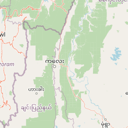
Map view of Shirui National Park

Use this park location map to pinpoint Shirui National Park in India, understand its exact geographic position, and read its mapped placement within the surrounding landscape more clearly.

Pigeon | © OpenStreetMap contributors

Location context for Shirui National Park

Manipur
Park atlas

Compare the surrounding Himalayan landscapes and diverse conservation areas in Northeast India.

Explore Other National Parks and Protected Areas Near Shirui National Park

Browse additional national parks and protected areas geographically connected to Shirui National Park and its unique Himalayan ecosystems. This exploration allows for comparison of diverse conservation landscapes across Northeast India, revealing broader regional patterns and natural heritage.
National parkManipur
About 56 km away#1 closest

Northwest

Keibul Lamjao National Park: Mapped Boundaries and Protected Landscape Identity

Explore Manipur's unique national park geography and terrain.

Keibul Lamjao National Park represents a key protected area within the state of Manipur, India, offering critical insights into regional geography and protected landscape dynamics. This national park's unique environmental setting provides an excellent opportunity for structured atlas exploration, allowing users to understand its mapped boundaries and its significance within the subcontinent's network of conservation areas. Discover the specific geographic context and natural terrain that define Keibul Lamjao National Park.

Area
40 km²
Established
1977
IUCN
II
Relief
Lowland
Wildlife reserveManipur
About 58 km away#2 closest

Northwest

Loktak Lake Wildlife Reserve in Manipur: Mapping Floating Wetland Geography

Explore the unique terrain, mapped boundaries, and freshwater ecology of India's largest floating wetland

Loktak Lake Wildlife Reserve presents a distinctive landscape of shifting phumdi islands and expansive freshwater marshes within the Manipur Valley. This protected area offers deep geographic insight into a complex wetland system that pulses with the monsoon season, providing a critical refuge for biodiversity and maintaining hydrological balance in Northeast India.

Area
287 km²
Established
1990
Relief
Lowland
Climate
Tropical
National parkChamphai
About 117 km away#3 closest

Southwest

Murlen National Park: Mapped Protected Landscape and Regional Geographic Context

National Park discovery in Champhai, India.

Delve into the specifics of Murlen National Park, a key protected area situated in the Champhai region. This entry focuses on its identity as a National Park, providing critical information about its geographic placement and mapped boundaries. Understanding Murlen National Park within its regional landscape context is fundamental for comprehensive atlas-based exploration of India's protected areas.

Area
200 km²
Established
1991
IUCN
II
Relief
Mountain
National parkIndia
About 167 km away#4 closest

Northwest

Intanki National Park: An Atlas Perspective on India's Protected Landscape

Mapping the boundaries and regional geography of this national park.

Delve into Intanki National Park, a significant protected area within India, through an atlas and map-focused lens. This detail page provides insights into its protected landscape identity, geographic setting, and the broader context of natural terrain found in India. Understand its specific placement and role within the national park system, offering a foundation for detailed geographic study and exploration.

Wildlife reserveAssam
About 183 km away#5 closest

Northwest

Borail Wildlife Sanctuary: Protected Evergreen Forest Landscapes in the Barail Range

Exploring the terrain and habitat boundaries of southern Assam

Borail Wildlife Sanctuary spans the transition from the Surma valley floor to the hill country of the Barail range. This protected area serves as a critical refuge for primates, hornbills, and endemic plant species. The sanctuary offers a mapped look at one of the most ecologically significant, forest-covered landscapes in the Barak valley region, defined by steep ridges and monsoon-fed stream networks.

Area
326.24 km²
Established
2004
IUCN
IV
Relief
Mountain
National parkSagaing Region
About 206 km away#6 closest

South

Alaungdaw Kathapa National Park: National Park with Mapped Boundaries in Sagaing Region

Explore its protected landscape and regional geography.

Alaungdaw Kathapa National Park is a protected natural area situated in Myanmar's Sagaing Region. This national park is defined by its specific geographic boundaries and serves as a key component within the regional landscape atlas. Its designation highlights its importance for conservation and offers insights into the natural terrain and protected area distribution, providing a focused entry for geographic study.

Area
1,403 km²
Established
1989
IUCN
II
Relief
Mountain
Wildlife reserveAssam
About 206 km away#7 closest

Northwest

East Karbi-Anglong Wildlife Sanctuary: Geographic Overview and Hill Forest Map

Protected wildlife reserve within the Karbi Anglong district of Assam.

The East Karbi-Anglong Wildlife Sanctuary occupies a significant portion of the Karbi Anglong plateau, encompassing 222 square kilometers of rolling hills and narrow valleys. This protected area supports a mosaic of forest habitats, ranging from moist evergreen patches to drier deciduous ridges. It functions as an essential refuge for tigers, elephants, and primates, while maintaining a rich avian community of approximately 250 recorded species.

Area
221.81 km²
Established
2000
IUCN
IV
Relief
Upland
National parkIndia
About 211 km away#8 closest

Southwest

Phawngpui National Park: An Indian National Park's Protected Landscape and Geography

Explore its mapped boundaries and regional natural terrain.

Phawngpui National Park stands as a distinct protected area within India, contributing significantly to the nation's atlas of natural landscapes. Its designation as a national park underscores its importance for understanding regional geography and mapped terrain. This profile focuses on the park's specific protected-area identity and its role in the broader geographic context of India, offering clear insights for landscape and park map discovery.

Area
50 km²
Established
1992
IUCN
II
Visitors
469 annual

Common questions about visiting, size, designation, and location context for Shirui National Park

Shirui National Park FAQs for park facts, access, geography, and protected area context

Find quick answers about Shirui National Park, including protected-area facts, park geography, trail and visitor context, and how the park fits into its surrounding country and regional landscape.
MoriAtlas Explorer

Continue Your Protected Areas Search Across the Global Atlas

Deepen your exploration by continuing the structured search for national parks and protected areas worldwide. Utilize the comprehensive filtering capabilities to compare different conservation landscapes and refine your understanding of global park geography. Discover more about the distribution and characteristics of protected natural areas.

Global natural geography
