
Mori Atlas logo
Protected landscapeChełmiński Park Krajobrazowy

Analyzing the glacial moraine uplands and riverine floodplain geography of Northern Poland

Chełmiński Park Krajobrazowy: Mapped Protected Landscapes along the Lower Vistula River Valley

Chełmiński Park Krajobrazowy spans a significant corridor along the right bank of the Lower Vistula in the Kuyavian-Pomeranian Voivodeship. This protected landscape encompasses a distinct transition between the wide fluvial valley and the undulating moraine plateaus of the Chełmno Lake District. Through its structured nature reserves and varied terrain, the area provides a definitive cross-section of post-glacial landforms, including kettle holes, lake basins, and floodplain forests.

landscape parklower vistulavistula valleymoraine landscapeglacial terrainfloodplain forest
A digital illustration of a waterfall flowing down a rocky cliff into a river, surrounded by pine trees, with mountains in the background and a bright sun in the sky.

Chełmiński Park Krajobrazowy

Protected landscape

Park overview

Structured park overview, official facts, and landscape profile for Chełmiński Landscape Park

Chełmiński Landscape Park park facts, protected area profile, and essential visitor context

Review the core facts for Chełmiński Landscape Park, including designation, size, terrain, visitor scale, habitats, and operating context in one park-focused overview.

About Chełmiński Landscape Park

Chełmiński Landscape Park occupies a long, north-south running strip on the right bank of the Lower Vistula in the Kuyavian-Pomeranian Voivodeship. The protected area begins near Unisław in the south and continues northward toward Grudziądz, following both the river's valley edge and the adjacent uplands of the Chełmno Lake District. Roughly 223 square kilometers of terrain fall under its protection, making it one of the more substantial landscape parks in the region.

The park's territory spans two adjacent physical-geographical mesoregions: the Fordon Valley (Dolina Fordońska) associated with the Lower Vistula, and the Chełmno Lake District (Pojezierze Chełmińskie), a classic area of young glacial morphology. This positioning gives the park a layered topography in which flat floodplain, river terrace, valley slope, and moraine upland sit close together. The visual character shifts accordingly, from open river-bottom landscapes near the Vistula to forested hills and small lake basins further inland.

Five nature reserves lie entirely within the park, each safeguarding a distinctive element of this landscape: the Góra św. Wawrzyńca reserve on a prominent moraine hill, the floodplain forests of Łęgi na Ostrowiu Panieńskim and Ostrów Panieński, and the lakeside and slope habitats of Płutowo and Zbocza Płutowskie. These reserves reflect the park's role as a refuge for habitats that, elsewhere along the Lower Vistula, have been heavily modified by agriculture and development.

Administratively, Chełmiński Landscape Park has gone through several reorganizations since its creation in 1998. It was briefly merged with the Nadwiślański Landscape Park on the opposite bank of the Vistula, an arrangement that was later struck down by administrative courts and reverted. Today it operates together with the Nadwiślański Landscape Park and the Góry Łosiowe Landscape Park under the umbrella of the Lower Vistula Landscape Parks Complex, headquartered in Świecie. This administrative structure reflects the ecological continuity of the valley, even though each park remains legally a separate entity.

Quick facts and research context for Chełmiński Landscape Park

Chełmiński Landscape Park is a Polish protected landscape category (park krajobrazowy) located in the Kuyavian-Pomeranian Voivodeship. It lies along the right bank of the Lower Vistula valley and falls within the Fordon Valley and Chełmno Lake District mesoregions. Established on 15 May 1998 under regulation of the Toruń Voivode, the park covers approximately 223 square kilometers and contains five nature reserves within its boundaries. It is jointly administered with neighboring landscape parks through the Lower Vistula Landscape Parks Complex based in Świecie.

Protection and recognition

Examine the official terrestrial conservation boundaries and designation framework.

Chełmiński Park Krajobrazowy Protection Status and Conservation Scope

Chełmiński Park Krajobrazowy maintains a documented terrestrial protection scope within the regional landscape registry. Conservation records outline the established designation framework and administrative management boundaries without external international listings.

Protection details

Protection scope
Terrestrial
Park context

Deeper park guide and search-rich context for Chełmiński Landscape Park

Chełmiński Landscape Park history, landscape, wildlife, and travel context

Explore Chełmiński Landscape Park through its history, landscape character, ecosystems, wildlife, conservation priorities, cultural context, and seasonal travel timing in a structured park guide built for atlas discovery and search intent.

Why Chełmiński Landscape Park stands out

Chełmiński Landscape Park is best known for its position along the right bank of the Lower Vistula, where glacial features of the Chełmno Lake District meet the river's wide lowland valley. The park preserves a continuous belt of moraine uplands, post-glacial lake basins, valley slopes, and fragments of floodplain forest, offering a compact cross-section of the post-glacial landscape that defines much of northern Poland. Its five nature reserves are central to the park's identity, protecting especially valuable fragments such as the Góra św. Wawrzyńca hill, riverine floodplain forests on Ostrów Panieński, and the slope habitats of Zbocza Płutowskie. Together they highlight the variety of geological and ecological patterns concentrated within a relatively narrow zone next to the Vistula.
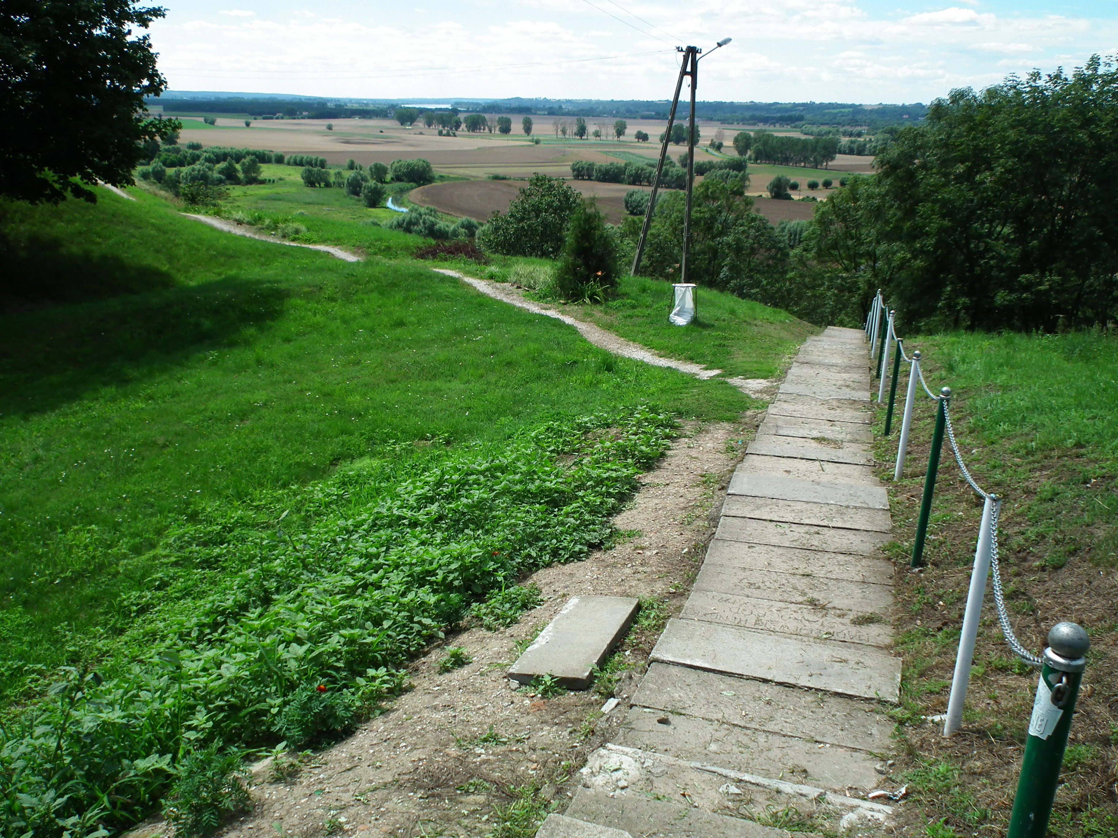
A downward sloping concrete staircase with a rope railing leads from a grassy hill overlooking a valley with fields and trees in Poland.
A scenic overlook in Starogrod within Chełmiński Park Krajobrazowy.

Chełmiński Landscape Park history and protected-area timeline

Chełmiński Landscape Park was established by Regulation No. 11/98 of the Toruń Voivode, dated 15 May 1998, as a landscape park within the Kuyavian-Pomeranian Voivodeship. From the outset it was conceived not as an isolated protected area but as part of a longer corridor of conservation along the Lower Vistula.

In March 1999 the park was merged with the Nadwiślański Landscape Park on the opposite bank to form a single Lower Vistula Valley Landscape Park (renamed in 2003 the Combined Landscape Parks of Chełmiński and Nadwiślański). The merger was later invalidated by the Supreme Administrative Court, and the parks were separated again. By September 2005 the combined structure was formally dissolved and both parks resumed functioning independently, while still sharing a common management unit bearing the original combined name.

In 2018 the management entity was further reorganized when the newly created Góry Łosiowe Landscape Park was added to the group, and the entire structure was renamed the Lower Vistula Landscape Parks Complex (Zespół Parków Krajobrazowych nad Dolną Wisłą), headquartered in Świecie. This remains the current administrative framework under which Chełmiński Landscape Park operates.

Chełmiński Landscape Park landscape and geographic character

The landscape of Chełmiński Landscape Park is defined by the contrast between the broad, flat valley of the Lower Vistula and the higher, undulating terrain of the Chełmno Lake District on its eastern side. The park sits on the right bank, so its topography rises gradually inland from the river toward the moraine uplands. Viewers traveling through the park encounter a sequence of clearly different landscape types within short horizontal distances.

Along the Vistula edge, the terrain consists of low floodplain and river terrace landforms shaped by the river's lateral migration. Moving east, the land rises through valley slopes and kame-like features toward the moraine plateaus, kettle holes, and small post-glacial lakes that characterize the Chełmno Lake District. This transition between fluvial and glacial landforms is one of the park's defining physical traits.

The five nature reserves capture some of the most distinctive landforms in the area. Góra św. Wawrzyńca protects a prominent isolated hill rising above the surrounding plain, while Zbocza Płutowskie and Płutowo focus on valley slopes and lake basins. The two Ostrów Panieński reserves preserve island-like sections of floodplain forest within the river's channel corridor, providing a rare illustration of the Vistula's natural floodplain dynamics.

Chełmiński Landscape Park ecosystems, habitats, and plant life

Ecologically, the park functions as a transitional zone between the aquatic and riparian habitats of the Vistula and the terrestrial communities of the moraine uplands. Floodplain forests along the river, including the willow and alder stands preserved in the Ostrów Panieński reserves, represent one of the habitats most threatened by river regulation across Poland and are therefore a focal point of conservation within the park.

Away from the river, the moraine hills and kettle holes of the Chełmno Lake District support mixed deciduous and mixed coniferous forests, small lake and pond ecosystems, and a network of meadow and slope communities. The transition zones between these habitats, particularly along the valley slopes, hold important concentrations of botanical diversity, which is part of the rationale behind the Płutowo and Zbocza Płutowskie reserves.

Taken as a whole, the park protects a compact mosaic of lowland habitats rather than a single large ecosystem. This habitat diversity, compressed into a relatively narrow band along the Lower Vistula, is what gives Chełmiński Landscape Park its ecological significance within the broader Kuyavian-Pomeranian landscape.

Chełmiński Landscape Park wildlife and species highlights

Chełmiński Landscape Park supports a characteristic lowland central European fauna, with animal communities shaped by the juxtaposition of riverine, wetland, farmland, and forest habitats. The floodplain forest remnants and river edge environments preserved in the Ostrów Panieński reserves are particularly important for birds associated with large lowland rivers, including species dependent on natural or semi-natural riparian conditions that have become rare elsewhere in the region.

The lake and pond systems associated with the glacial terrain in the eastern part of the park attract typical waterbird and wetland species, while the surrounding mixed forests support the usual range of central European woodland mammals and breeding birds. The slopes and meadows along the transition between valley and upland host additional insect and plant communities that contribute to overall habitat heterogeneity.

While the park is not primarily known as a single charismatic species destination, its value for wildlife lies in the persistence of habitat mosaics that remain functional amid a heavily modified agricultural and urban landscape, giving many species a refuge within the Lower Vistula corridor.

Chełmiński Landscape Park conservation status and protection priorities

Chełmiński Landscape Park was established to protect the geological, scenic, and ecological values of a representative stretch of the Lower Vistula right bank, including its glacial, fluvial, and biological features. Within the Polish protected-area framework, the park krajobrazowy status provides protection for landscape character and ecological function, while the five embedded nature reserves add a stricter layer of conservation for specific sites of particular scientific or natural value.

The reserves are concentrated in landscape elements most vulnerable to loss: the isolated moraine hill of Góra św. Wawrzyńca, the rare riverine floodplain forests of Ostrów Panieński, and the lake and slope habitats of Płutowo and Zbocza Płutowskie. By grouping these reserves within a single landscape park, the protection system links landscape-scale conservation with site-level safeguards.

The park's integration into the larger Lower Vistula Landscape Parks Complex also reflects a conservation strategy at the valley scale. Coordinating management across the right and left banks of the Vistula and adjacent upland parks allows for a more coherent approach to riverine habitats, ecological corridors, and the long-term preservation of landscape character along one of Poland's major rivers.

Chełmiński Landscape Park cultural meaning and human context

The park's landscape is closely tied to the historical and cultural geography of the Chełmno region, an area long associated with agriculture, small towns, and the Vistula as a transport and communication corridor. Villages such as Unisław and the broader Chełmno surroundings have shaped and been shaped by the river valley for centuries, leaving a pattern of settlements, field systems, and routes that still frames the protected landscape today.

The depiction of the park on the Wikipedia page features the village of Starogród near Chełmno, illustrating the close coexistence of rural communities and protected natural values. This human presence, including traditional land use and the cultural heritage of the Chełmno area, forms part of the broader context within which the park operates and is managed.

Top sights and standout views in Chełmiński Landscape Park

Chełmiński Landscape Park stands out for combining a long, narrow protected corridor along the Lower Vistula with five distinct nature reserves embedded within it. The juxtaposition of glacial moraine landscapes and a major lowland river valley gives the park unusually compact ecological and scenic diversity.

Its particular highlights include the protected moraine hill Góra św. Wawrzyńca, the Vistula floodplain forests of Ostrów Panieński, and the slope and lake habitats of Płutowo and Zbocza Płutowskie. The park's role within the Lower Vistula Landscape Parks Complex also makes it a key element of conservation strategy for the entire Lower Vistula valley.

Best time to visit Chełmiński Landscape Park

Chełmiński Landscape Park has the character of a lowland Polish landscape park, with the most rewarding visits typically associated with the warmer half of the year. Late spring and early summer bring active vegetation and birdlife to the floodplain forests, slopes, and lake margins, while early autumn softens the light across the moraine uplands and is often a calmer time for walking the park's trails.

Winter visits offer a quieter but distinctly different experience, with forests, hill reserves, and river-edge landscapes taking on a colder, more austere atmosphere. Because the park spans both riverine and glacial terrain, conditions can vary noticeably across short distances, so visitors should be prepared for locally muddy ground after thaw or rainfall at any time of year.
Monthly climate preview

Long-term representative point measurements for monthly temperature and precipitation variation

Chełmiński Park Krajobrazowy Climate Normals and Annual Temperature Rhythm

Representative point records from 1991 to 2020 outline the measured long-term temperature and precipitation rhythm across twelve recorded months in Chełmiński Park Krajobrazowy. Detailed monthly breakdowns provide complete analytical depth for comparing seasonal variations across this protected area coordinate.
Annual mean8 °C
-3 °C19 °C
Jan-3°
Feb-2°
Mar
Apr
May13°
Jun17°
Jul19°
Aug19°
Sep14°
Oct
Nov
Dec-1°
Warmest month
July

19.4 °C

Coolest month
January

-3.2 °C

Wettest month
July

2.6 mm/day

Driest month
April

1.3 mm/day

Park location guide

Geography guide, regional context, and park location map for Chełmiński Landscape Park

Chełmiński Landscape Park park geography, regions, and map view in Poland

Understand where Chełmiński Landscape Park sits in Poland through a broader geographic reading of the surrounding landscape, nearby location context, and its mapped position within the national park landscape.

How Chełmiński Landscape Park fits into Poland

Poland, officially the Republic of Poland, is a Central European country spanning from the Baltic Sea in the north to the Carpathian Mountains in the south. It borders Germany, Czech Republic, Slovakia, Ukraine, Belarus, Lithuania, and Kaliningrad Oblast. The country has a temperate climate, diverse landscapes, and is known for its rich history, cultural heritage, and strong economic position within the EU.

Wider geography shaping Chełmiński Landscape Park in Poland

Poland occupies 312,696 km2 in Central Europe, extending from the Baltic Sea coast in the north to the Sudetes and Carpathian Mountains in the south. It borders Germany to the west, Czech Republic and Slovakia to the south, Ukraine and Belarus to the east, and Lithuania and Kaliningrad Oblast to the northeast. The landscape includes lowland plains, uplands, and mountain ranges.

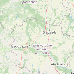
Map view of Chełmiński Landscape Park

Use this park location map to pinpoint Chełmiński Landscape Park in Poland, understand its exact geographic position, and read its mapped placement within the surrounding landscape more clearly.

Pigeon | © OpenStreetMap contributors

Location context for Chełmiński Landscape Park

Kuyavian-Pomeranian Voivodeship

Explore protected habitats, moraine terrain, and river valley scenery across the reserve.

Chełmiński Park Krajobrazowy Photos and Scenery: Visualizing Vistula Valley Landscapes

Visual records capture the distinctive contrast between the broad Vistula river valley and the undulating glacial moraine uplands of Chełmiński Park Krajobrazowy. Detailed photography reveals slope habitats, floodplain forests, and post-glacial landforms across the protected landscape.

A downward sloping concrete staircase with a rope railing leads from a grassy hill overlooking a valley with fields and trees in Poland.

Park atlas

Compare adjacent river valley reserves, glacial terrain, and regional lowland geography.

Explore Parks Near Chełmiński Park Krajobrazowy and Surrounding Protected Landscapes

Browse protected areas near the surrounding region to compare glacial moraine plateaus and river valley reserves adjacent to Chełmiński Park Krajobrazowy. Expanding the search reveals broader ecological patterns across the Lower Vistula landscape complex.
Protected areaKujawsko-Pomorskie Voivodeship
Park boundaries overlap#1 closest

Southwest

Solecka Dolina Wisły: Mapping the Middle Vistula River Valley Protected Landscapes

Protected riverine habitats in Kujawsko-Pomorskie Voivodeship

The Solecka Dolina Wisły protected area captures the ecological structure of the Vistula River valley. From active sandy bars in the river channel to oak-hornbeam woodlands on the upper valley slopes, the site offers a detailed look at lowland riverine geography, flood-plain dynamics, and xerothermic grassland habitats within the Polish landscape.

Area
70.301 km²
Established
2009
Relief
Lowland
Scope
Terrestrial
Protected areaKuyavian-Pomeranian Voivodeship
Park boundaries overlap#2 closest

Southwest

Zbocza Płutowskie Protected Area: Ecological Geography and Habitat Mapping in Kuyavian-Pomeranian

A protected landscape featuring xerothermic slopes and riverine forest mosaics

Located in the Kuyavian-Pomeranian Voivodeship, Zbocza Płutowskie is a protected area preserving a mosaic of rare xerothermic grasslands and mature deciduous woodlands. The site showcases the importance of lowland habitat connectivity, including oak-hornbeam communities and riparian forests, offering a detailed perspective on regional ecological terrain.

Area
10.114 km²
Relief
Lowland
Climate
Temperate
Access
Access unknown
Protected landscapeKuyavian-Pomeranian Voivodeship
12 km away#3 closest

Northwest

Wdecki Park Krajobrazowy: Protected Landscape Atlas and Regional Geography

Forest and river basin terrain in Poland

Examine the geographic foundation of Wdecki Park Krajobrazowy, a protected landscape characterized by the Wda River drainage, glacial erratics, and extensive pine forests. The area supports a rich variety of wetland flora, mires, and managed reservoirs such as the Żur, making it a significant conservation landmark within the wider Bory Tucholskie region of northern Poland.

Area
191.77 km²
Established
1993
Relief
Lowland
Climate
Temperate
A minimalist watercolor painting showing a calm lake or wetland surrounded by soft green trees and gentle hills under a light sky.
Protected areaKuyavian-Pomeranian Voivodeship
19 km away#4 closest

North

Sandr Wdy Protected Area: Glacial Geography and Wetland Habitats in Northern Poland

An essential reference area for Bory Tucholskie forest ecology.

Sandr Wdy is a distinctive Natura 2000 protected area shaped by post-glacial processes. The landscape features a flat outwash plain punctuated by lake basins, river valleys, and diverse mire systems. With multiple strict nature reserves integrated into its boundaries, the site provides a comprehensive view of how hydrological and soil conditions influence habitat distribution within the broader forest landscape of Poland.

Area
63.21 km²
Established
2011
Relief
Lowland
Climate
Temperate
Nature reserveKuyavian-Pomeranian Voivodeship
About 22 km away#5 closest

Northeast

Rezerwat przyrody Dolina Osy: Geographic Atlas of an Osa River Valley Protected Area

Riverine landscapes in the Kuyavian-Pomeranian Voivodeship

This nature reserve serves as a prime example of post-glacial river valley preservation in the Chełmińskie Lakeland. The protected area features a diverse mosaic of lowland valley terrain, including river channels, wet bottomlands, and woodland corridors, illustrating the complex geography of north-central Poland.

Area
6.679 km²
Established
1994
Relief
Upland
Climate
Temperate
A panoramic watercolor illustration showing a calm lake bordered by pine trees and patches of pink shrubs under a pale sky.
Nature reservePoland
About 24 km away#6 closest

North

Rezerwat przyrody Miedzno: Wetland and Peatland Protected Area in Northern Poland

Geographic atlas of the Miedzno nature reserve and its glacial valley.

Rezerwat przyrody Miedzno represents a vital ecological corridor in Poland, defined by its flow-through lake, alder-birch swamp forests, and rare marshland flora. This nature reserve, situated within the Wdecki Landscape Park, provides a detailed view into the post-glacial topography and avian conservation landscapes of the Bory Tucholskie mesoregion.

Area
0.885 km²
Established
1968
Relief
Lowland
Climate
Temperate
A watercolor painting showing a soft, atmospheric landscape with a winding body of water, green treelines, and patches of pinkish bog vegetation against a pale, warm sky.
Nature reserveKuyavian-Pomeranian Voivodeship
About 26 km away#7 closest

North

Dury Nature Reserve: Protected Wetland and Peatland Geography in Kuyavian-Pomeranian Voivodeship

Strictly protected dystrophic lake and bog habitats

Dury Nature Reserve is a specialized botanical and hydrological site in the Tuchola Forest. It preserves a distinct mosaic of four dystrophic lakes surrounded by peat bogs. The reserve is a core component of local wetland conservation, protecting rare bog species and maintaining the integrity of northern Polish forest ecosystems.

Area
0.13 km²
Established
1975
Relief
Lowland
Climate
Temperate
Nature reservePomeranian Voivodeship
About 27 km away#8 closest

North

Rezerwat przyrody Jezioro Udzierz Nature Reserve Geographic and Ecological Overview

Wetland habitat mosaic in the Pomeranian Voivodeship

Rezerwat przyrody Jezioro Udzierz protects a compact yet biodiverse wetland mosaic centered on Lake Udzierz. Located in the heart of the Bory Tucholskie forest, the reserve integrates open water, reedbeds, peatlands, and wet meadows into a single, cohesive ecological unit. This detailed view examines the reserve's protected status, landscape composition, and its vital role as a refuge for bird species within the wider geography of northern Poland.

Area
2.299 km²
Established
2000
Relief
Lowland
Climate
Temperate

Common questions about visiting, size, designation, and location context for Chełmiński Landscape Park

Chełmiński Landscape Park FAQs for park facts, access, geography, and protected area context

Find quick answers about Chełmiński Landscape Park, including protected-area facts, park geography, trail and visitor context, and how the park fits into its surrounding country and regional landscape.
MoriAtlas Explorer

Continue Your Protected Areas Search Across the Global Atlas

Deepen your exploration by continuing the structured search for national parks and protected areas worldwide. Utilize the comprehensive filtering capabilities to compare different conservation landscapes and refine your understanding of global park geography. Discover more about the distribution and characteristics of protected natural areas.

Global natural geography