Peaks
Cerro La Paila
3,605 m

Analyzing regional distribution, mountain terrain, and protected natural features in Colombia
This geographic dataset provides a detailed overview of the 766 square kilometer territory within Chingaza National Natural Park in the Cundinamarca and Meta regions of Colombia. The analysis covers the vertical relief ranging from 800 to 4020 meters, spanning mountainous peaks, alpine meadows, and extensive wetland habitats.
Related tags
High-altitude Andean páramo reserve protecting glacial lakes and critical watersheds for Bogotá
Chingaza National Natural Park is a protected high-altitude area in the Eastern Ranges of the Colombian Andes, situated northeast of Bogotá across the departments of Cundinamarca and Meta. The park encompasses a dramatic elevational gradient from 800 to 4,020 meters, encompassing the páramo ecosystem, Andean forests, and the transition zone above the Altiplano Cundiboyacense. Established in 1977 and managed within Colombia's National System of Protected Areas, Chingaza protects one of the most ecologically significant mountain environments in the country, characterized by an extensive network of glacial lakes, endemic vegetation communities, and critical hydrological function. The park's lake system was designated a Ramsar Wetland in 2008, recognizing its international importance as a water regulation and biodiversity conservation area.
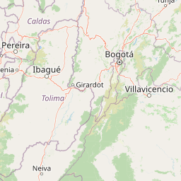
Mapping the regional boundaries across Cundinamarca and Meta
Charting the 766 square kilometer footprint and spatial coordinates
Mountain relief span from 800 meters to 4020 meters
Peaks
3,605 m
Peaks
Peaks
3,670 m
Waterfalls
Lakes
3,340 m
Rivers
Montane forest habitats, subtropical climate zones, and mountain relief profiles
Mountains · Lakes · Rivers · Wetland · Grassland · Glacier
Montane forest · Alpine meadow · Wetland · Peatland · Riverine habitat · Grassland
Map the regional spread of conserved mountain environments and high-altitude ecosystems across the Colombian Andes
West

Explore its mapped boundaries and regional geographic context.
Sumapaz National Park represents a significant protected area within the broader geographic tapestry of Colombia. As a designated national park, its mapped boundaries are central to understanding its protected landscape identity. This detail page offers focused insight into the park's role in conservation and its specific geographic setting, providing essential context for atlas and map exploration without delving into visitor logistics. Examine the terrain and regional significance of this important natural landscape.
West
Detailed map context and protected land geography.
Los Nevados National Natural Park serves as a key protected area within Colombia, offering rich opportunities for geographic discovery. This page details the park's mapped boundaries and its contribution to the broader atlas of South American protected lands. Explore the unique landscape character and regional geographic significance that define Los Nevados National Natural Park as a vital natural reserve.
North
Explore mapped boundaries and regional landscape context.
Yariguíes National Park stands as a crucial protected area within the Santander Department, offering a distinct landscape for geographic study. As a designated national park, it provides vital context for understanding Colombia's protected lands and their regional distribution. This detailed view allows for in-depth exploration of its mapped terrain and natural geography, suitable for atlas-oriented discovery.
West
Mapped boundaries and regional geography of a Colombian national park.
Tatamá National Natural Park is a protected natural area situated within the Republic of Colombia. As a designated national park, it contributes significantly to the nation's protected lands. This entry provides essential geographic context, focusing on the park's mapped outlines and its role within the broader atlas of Colombian geography. Understanding Tatamá National Natural Park involves appreciating its specific landscape features and its contribution to the country's network of protected natural areas, offering a foundation for regional geographic study.
Southwest
Understand the mapped boundaries of this Colombian national park.
Las Hermosas National Natural Park represents a vital protected landscape, offering critical insights into the geography of Colombia's Valle del Cauca Department. This entry delves into the park's specific mapped boundaries and its environmental significance, providing users with structured geographic information for detailed atlas exploration. Gain a clear understanding of the park's identity as a national natural park and its contribution to the regional natural landscape.
Northeast
Explore mapped natural features and protected area context.
Delve into the protected landscape of Tamá National Natural Park, a key national park situated in Colombia's Norte de Santander region. This resource provides an atlas-style overview of the park's geographic setting, emphasizing its mapped boundaries and its role within the broader regional geography. Understand the inherent natural context and protected status of this significant Colombian conservation area through detailed landscape information.
Northwest
Explore its unique elevational gradient and protected terrain.
Las Orquídeas National Natural Park in Colombia is renowned for its dramatic elevational range, compressing multiple distinct ecosystems into a single protected area. This national park offers an exceptional view of Andean geography and Chocó biogeographic region biodiversity, transitioning from tropical rainforest to high-altitude páramo. Investigate the mapped landscape and the conservation significance of this unique natural treasure.

West
Explore mapped boundaries and regional context.
Farallones de Cali National Park offers a distinct protected landscape within Valle del Cauca Department. This page provides atlas-level detail on its geographic scope and mapped features, crucial for understanding its regional context. Dive into the protected-area specifics to grasp the natural terrain and conservation landscape that defines this significant Colombian national park.
Deepen your understanding of Chingaza National Natural Park by exploring its specific mapped terrain and regional geography. This detailed park entry provides the foundational context for comprehending its protected landscape identity and its contribution to Colombia's natural atlas. Continue your structured discovery of Chingaza National Natural Park's unique geographic features and conservation significance.