Mori Atlas logo
National parkChingaza National Natural Park

Discover the mapped boundaries and regional terrain of this national park in Colombia.

Chingaza National Natural Park: Colombia's Protected Landscape and Geographic Atlas Entry

(Parque Nacional Natural Chingaza)

Chingaza National Natural Park stands as a significant protected area within Colombia's diverse geography. This page serves as a detailed atlas entry, illuminating the park's specific geographic scope, its mapped boundaries, and its role as a protected natural landscape. Explore the foundational elements that define Chingaza National Natural Park's unique position within the broader Colombian terrain and conservation atlas.

Páramo ecosystemGlacial lakesAndean mountainsHigh-altitude protected areaRamsar wetlandWater watershed

Chingaza National Natural Park

National park

Park overview

Structured park overview, official facts, and landscape profile for Chingaza National Natural Park

Chingaza National Natural Park park facts, protected area profile, and essential visitor context
Review the core facts for Chingaza National Natural Park, including designation, size, terrain, visitor scale, habitats, and operating context in one park-focused overview.

About Chingaza National Natural Park

Chingaza National Natural Park represents one of Colombia's most important protected areas for high-altitude Andean conservation. Located in the Eastern Ranges of the Colombian Andes northeast of Bogotá, the park encompasses a remarkable elevational span of over 3,200 meters, creating diverse habitats from premontane forest through Andean cloud forest to the unique páramo ecosystem above 3,000 meters. The park's primary significance lies in its water regulation function: the extensive glacial lake network and páramo vegetation act as a natural sponge, capturing moisture and slowly releasing it to supply approximately 80% of Bogotá's drinking water through the Chingaza System managed by the Bogotá Water Company. This critical ecosystem service, combined with exceptional biodiversity and cultural heritage value, makes Chingaza a cornerstone of Colombia's environmental protection strategy. The park spans four municipalities and represents a vital ecological corridor connecting different altitudinal zones and watersheds.

Quick facts and research context for Chingaza National Natural Park

Chingaza National Natural Park covers 766 square kilometers in the Eastern Ranges of the Colombian Andes, approximately 70 kilometers northeast of Bogotá. The park spans the boundary between Cundinamarca and Meta departments, encompassing the municipalities of La Calera, Fómeque, Guasca, and San Juanito. Elevations range from 800 meters in the lower forested zones to 4,020 meters at Cerro del Fute, with temperatures varying from 4°C to 21.5°C across this gradient. The park contains approximately 40 glacial lakes, with Lake Chingaza being the largest at 3,250 meters altitude. The park is part of the Orinoco River basin and contributes approximately 80% of Bogotá's high-quality drinking water supply through the Chingaza System managed by the Bogotá Water Company.

Park context

Deeper park guide and search-rich context for Chingaza National Natural Park

Chingaza National Natural Park history, landscape, wildlife, and travel context
Explore Chingaza National Natural Park through its history, landscape character, ecosystems, wildlife, conservation priorities, cultural context, and seasonal travel timing in a structured park guide built for atlas discovery and search intent.

Why Chingaza National Natural Park stands out

Chingaza is best known for its spectacular high-altitude páramo ecosystem, one of the most important in Colombia, featuring endemic frailejones and unique wetland vegetation. The park protects the Chingaza lake system, a Ramsar-designated wetland that serves as the primary water source for Bogotá. The dramatic landscape transitions through distinct ecological zones from Andean forest to Andean páramo, supporting exceptional biodiversity including the endangered spectacled bear, Andean condor, and numerous endemic species. The Siecha Lakes hold particular cultural significance as former sacred ceremonial sites of the Muisca civilization, which inhabited the region for over 10,000 years.

Chingaza National Natural Park history and protected-area timeline

Chingaza National Natural Park was established in 1977 as part of Colombia's expanding national protected areas network under the National System of Protected Areas (SINAP). The designation reflected growing recognition of the ecological importance of Andean páramo ecosystems and the critical watershed function these high-altitude environments provide for downstream cities including Bogotá. In 2008, the park's lake system received Ramsar Convention designation as a Wetland of International Importance, formally recognizing its global significance for water regulation and biodiversity conservation. Prior to national park designation, the region had been historically significant for thousands of years as Muisca territory, with the Siecha Lakes serving as sacred ceremonial centers for this pre-Columbian civilization. The name Chingaza derives from the Chibcha language and means "middle of the width," reflecting the park's position in the Andean landscape.

Chingaza National Natural Park landscape and geographic character

The physical landscape of Chingaza National Natural Park is defined by its dramatic elevational range and position in the Eastern Ranges of the Colombian Andes. The terrain rises from approximately 800 meters in the lower areas to 4,020 meters at Cerro del Fute, the park's highest peak. The landscape encompasses the eastern edge of the Altiplano Cundiboyacense high plateau, transitioning into the steep mountain slopes characteristic of the Andean cordillera. The park's most striking feature is its extensive glacial lake network, containing approximately 40 lakes formed by past glaciation. The largest, Lake Chingaza, sits at 3,250 meters elevation in the southwestern part of the park. The Siecha Lakes, a group of three lakes in the Guasca municipality area, are among the most representative and culturally significant bodies of water. The Chuza Reservoir, located in the Chuza Guatiquía river basin, serves as the central water storage for Bogotá's Chingaza System. Hydrographically, 99% of the park drains into the Orinoco River basin through tributaries including the Black and White rivers, Guatiquía, Guacavía, and Guavio, while only 1% drains into the Magdalena River basin through the Teusacá and Bogotá River systems.

Chingaza National Natural Park ecosystems, habitats, and plant life

The ecological character of Chingaza is defined by its exceptional elevational diversity, supporting multiple distinct life zones within a relatively compact area. The park transitions through humid premontane forest at lower elevations, ascending through Andean cloud forest characterized by dense tree cover, epiphytes, and high humidity, to reach the páramo ecosystem above approximately 3,000 meters. The páramo represents the most distinctive ecological feature, a tropical alpine ecosystem found only in the northern Andes and considered one of the world's fastest-evolving biodiversity hotspots. Vegetation in the páramo is dominated by frailejones, large rosette-forming plants that are endemic to this ecosystem. Peat moss communities are particularly important in the park, with eight species recorded that can absorb up to 40 times their weight in water, playing a crucial role in water regulation. In the vicinity of Chingaza lake alone, 383 plant species have been recorded, and estimates suggest the total flora of the park may exceed 2,000 species. The park also serves as a critical watershed, with its páramo and lake system capturing and slowly releasing water that supplies approximately 80% of Bogotá's high-quality drinking water.

Chingaza National Natural Park wildlife and species highlights

Chingaza National Natural Park supports remarkable wildlife diversity, particularly notable given its high-altitude setting. The Eastern Ranges of Colombia are recognized as one of the most important geographic regions for wildlife in the country due to the high concentration of endemic species. Large mammals inhabiting the park include the endangered spectacled bear, deer species, tapirs, pumas, and jaguars. Smaller mammals such as ocelots, woolly monkeys, and nocturnal monkeys are also present. The avifauna is particularly rich and includes the iconic Andean condor, the national bird of Colombia, as well as cock-of-the-rocks, toucans, and turkeys. The diverse habitats created by the park's elevational gradient support this variety of species, with different animals occupying forest, scrub, and páramo zones according to their ecological preferences. The presence of so many species, including significant populations of large predators and flagship species, indicates the ecological integrity of the park's ecosystems.

Chingaza National Natural Park conservation status and protection priorities

Chingaza holds significant conservation importance at both national and international levels. The designation of the Chingaza lake system as a Ramsar Wetland in 2008 formally recognizes its international importance as a wetland of significance, particularly for water regulation and biodiversity conservation. The park protects the páramo ecosystem, one of the most biodiverse and rapidly evolving environments on Earth, and serves as a critical refuge for endemic species including the frailejones that characterize this high-altitude habitat. The park's role in water regulation is perhaps its most critical conservation function, with the páramo acting as a natural water tower for Bogotá and surrounding regions. The park falls within the Tropical Andes biodiversity hotspot, one of the world's most threatened regions, making its protection particularly important for global conservation efforts. The protection of connectivity between different elevational zones allows species to move in response to climate change and maintains the ecological processes that sustain the park's exceptional biodiversity.

Chingaza National Natural Park cultural meaning and human context

The region now encompassed by Chingaza National Natural Park holds deep cultural significance rooted in thousands of years of human occupation. The area was inhabited by Muisca and pre-Muisca populations for over 10,000 years, with archaeological evidence of settlement, rock shelters, and ceremonial use of the landscape. The Siecha Lakes were particularly important as sacred places of worship and respect, forming ceremonial centers for the Muisca civilization. Recent linguistic studies suggest that Chingaza in the Chibcha language of the Muisca may have been called Chim-wa-za, meaning "God's Night Mountains," reflecting the spiritual significance of this high-altitude landscape. Today, while no indigenous groups currently reside within the park boundaries, the surrounding area maintains a rural community with distinct cultural patterns and forms of organization. The park name itself derives from the Chibcha language, meaning "middle of the width," preserving the linguistic heritage of the region's pre-Columbian inhabitants.

Top sights and standout views in Chingaza National Natural Park

Chingaza National Natural Park offers exceptional natural and cultural highlights that distinguish it within Colombia's protected areas system. The park protects one of the most extensive glacial lake networks in the Colombian Andes, with Lake Chingaza at 3,250 meters and the culturally significant Siecha Lakes representing outstanding examples of high-altitude aquatic environments. The páramo ecosystem above 3,000 meters, with its endemic frailejones and unique wetland vegetation, provides habitat for species found nowhere else on Earth. The park supports populations of the endangered spectacled bear, Colombia's only bear species, as well as Andean condors, jaguars, and numerous other wildlife species. Perhaps most significantly, the park's watersheds supply approximately 80% of Bogotá's drinking water, making it essential for the capital city's water security. The combination of ecological significance, watershed function, cultural heritage, and biodiversity makes Chingaza one of Colombia's most important protected areas.

Best time to visit Chingaza National Natural Park

The best time to visit Chingaza National Natural Park is during the dry season, which typically runs from December through March. This period offers more stable weather conditions with lower precipitation and clearer skies, allowing visitors to better appreciate the park's landscapes and views. The páramo environment can be enjoyed year-round, though visitors should be prepared for the characteristic high-altitude climate with temperatures ranging from 4°C to 21.5°C depending on elevation and time of day. The wet season from April to November brings higher rainfall and more frequent cloud cover, though the landscapes remain lush and the waterfalls and lakes can be particularly scenic during this period. Regardless of when visited, the high-altitude environment requires appropriate preparation for variable weather conditions.

Park location guide

Geography guide, regional context, and park location map for Chingaza National Natural Park

Chingaza National Natural Park park geography, regions, and map view in Colombia
Understand where Chingaza National Natural Park sits in Colombia through a broader geographic reading of the surrounding landscape, nearby location context, and its mapped position within the national park landscape.

How Chingaza National Natural Park fits into Colombia

Colombia is a presidential republic located in the northern part of South America. It spans approximately 1.14 million km² and has a population of around 52 million. The country features the Andes mountain range, extensive Amazon rainforest, and coastal regions on both the Caribbean and Pacific. Spanish is the official language, and Bogotá serves as the capital and largest city.

Wider geography shaping Chingaza National Natural Park in Colombia

Colombia is located in the northwestern part of South America, bordering the Caribbean Sea to the north and the Pacific Ocean to the west. Its mainland neighbors are Venezuela to the east, Brazil to the southeast, Peru and Ecuador to the south and southwest, and Panama to the northwest. The terrain is diverse, featuring the Andes mountain range in the west, Amazon rainforest in the south and east, and coastal plains along both oceans.

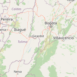
Map view of Chingaza National Natural Park

Use this park location map to pinpoint Chingaza National Natural Park in Colombia, understand its exact geographic position, and read its mapped placement within the surrounding landscape more clearly.

Pigeon | © OpenStreetMap contributors

Location context for Chingaza National Natural Park

CundinamarcaMeta
Park atlas

Map the regional spread of conserved mountain environments and high-altitude ecosystems across the Colombian Andes

Discover Nearby National Parks and Protected Areas Beyond Chingaza National Natural Park
Browse other national parks and protected areas situated within the Eastern Ranges of the Colombian Andes, extending your geographic discovery beyond Chingaza National Natural Park. Compare varied páramo ecosystems, glacial lake systems, and mountain forests to trace the regional spread of conserved landscapes in Colombia.
National parkColombia

Los Nevados National Natural Park: Colombia's National Park and Protected Landscape

Detailed map context and protected land geography.

Los Nevados National Natural Park serves as a key protected area within Colombia, offering rich opportunities for geographic discovery. This page details the park's mapped boundaries and its contribution to the broader atlas of South American protected lands. Explore the unique landscape character and regional geographic significance that define Los Nevados National Natural Park as a vital natural reserve.

Area
583 km²
Established
1973
IUCN
II
Visitors
39.9K annual
National parkSantander Department

Yariguíes National Park: National Park Geography and Protected Land Atlas

Explore mapped boundaries and regional landscape context.

Yariguíes National Park stands as a crucial protected area within the Santander Department, offering a distinct landscape for geographic study. As a designated national park, it provides vital context for understanding Colombia's protected lands and their regional distribution. This detailed view allows for in-depth exploration of its mapped terrain and natural geography, suitable for atlas-oriented discovery.

Area
788.37 km²
Established
2005
IUCN
II
Scope
Terrestrial
National parkColombia

Tatamá National Natural Park: Colombia's Protected Natural Landscape Explorer

Mapped boundaries and regional geography of a Colombian national park.

Tatamá National Natural Park is a protected natural area situated within the Republic of Colombia. As a designated national park, it contributes significantly to the nation's protected lands. This entry provides essential geographic context, focusing on the park's mapped outlines and its role within the broader atlas of Colombian geography. Understanding Tatamá National Natural Park involves appreciating its specific landscape features and its contribution to the country's network of protected natural areas, offering a foundation for regional geographic study.

Area
519 km²
Established
1987
IUCN
II
Relief
Mountain
National parkNorte de Santander

Tamá National Natural Park: Colombia's Protected Landscape and Regional Geography

Explore mapped natural features and protected area context.

Delve into the protected landscape of Tamá National Natural Park, a key national park situated in Colombia's Norte de Santander region. This resource provides an atlas-style overview of the park's geographic setting, emphasizing its mapped boundaries and its role within the broader regional geography. Understand the inherent natural context and protected status of this significant Colombian conservation area through detailed landscape information.

Area
480 km²
Established
1977
IUCN
II
Relief
Mountain
Watercolor painting of green hills, trees, and distant mountains under a light sky
National parkValle del Cauca Department

Farallones de Cali National Park: Protected Landscape and Geographic Atlas

Explore mapped boundaries and regional context.

Farallones de Cali National Park offers a distinct protected landscape within Valle del Cauca Department. This page provides atlas-level detail on its geographic scope and mapped features, crucial for understanding its regional context. Dive into the protected-area specifics to grasp the natural terrain and conservation landscape that defines this significant Colombian national park.

Area
1,500 km²
Established
1968
IUCN
II
Relief
Mountain
National parkColombia

Las Orquídeas National Natural Park: Colombia's Biodiversity Hotspot and Andean Ecosystem Atlas

Explore its unique elevational gradient and protected terrain.

Las Orquídeas National Natural Park in Colombia is renowned for its dramatic elevational range, compressing multiple distinct ecosystems into a single protected area. This national park offers an exceptional view of Andean geography and Chocó biogeographic region biodiversity, transitioning from tropical rainforest to high-altitude páramo. Investigate the mapped landscape and the conservation significance of this unique natural treasure.

Area
287.53 km²
Established
1974
IUCN
II
Relief
Mountain
National parkTáchira State

El Tamá National Park: A National Park in Venezuela's Táchira State for Geographic Discovery

Mapped protected area boundaries and regional landscape context.

El Tamá National Park serves as a primary point of interest for understanding Venezuela's protected lands. Located within Táchira State, this national park offers a distinct geographic profile for atlas exploration. Users can investigate the park's mapped features and its position within the regional natural landscape, gaining insight into its role as a conservation area and a component of Venezuela's broader geography.

Area
1,390 km²
Established
1978
IUCN
II
Relief
Mountain
National parkColombia

Chiribiquete National Park: A National Park in Colombia's Geographic Atlas

Explore protected land and mapped terrain within Colombia.

Chiribiquete National Park offers a crucial point for exploring Colombia's protected natural areas. As a national park, its geographic scope and mapped landscape provide valuable context for understanding conservation efforts and regional geography. This page serves as an atlas entry, detailing the park's boundaries and its importance within the broader South American context.

Area
43,000 km²
Established
2018
Relief
Mountain
Climate
Tropical

Common questions about visiting, size, designation, and location context for Chingaza National Natural Park

Chingaza National Natural Park FAQs for park facts, access, geography, and protected area context
Find quick answers about Chingaza National Natural Park, including protected-area facts, park geography, trail and visitor context, and how the park fits into its surrounding country and regional landscape.
MoriAtlas Explorer

Continue Your Protected Areas Search Across the Global Atlas

Deepen your exploration by continuing the structured search for national parks and protected areas worldwide. Utilize the comprehensive filtering capabilities to compare different conservation landscapes and refine your understanding of global park geography. Discover more about the distribution and characteristics of protected natural areas.

Global natural geography